We found 109182 price guide item(s) matching your search
There are 109182 lots that match your search criteria. Subscribe now to get instant access to the full price guide service.
Click here to subscribe- List
- Grid
-
109182 item(s)/page


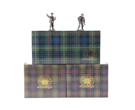
Lot 291
3 King & Country German WW2 German Forces 1944 sets. Advance To Attack (WSS48) 4 Waffen SS soldiers - with mine and rifle, signalling with Luger, crouching with rifle and crouching with Schmeisser machine gun. Plus Panzer Meyer Set (WSS173) two soldiers - Hitlerjugend 12SS Div – Officer with map and soldier with Schmeisser. Plus Volksturm Off To Battle (WSS182) soldier with hand held mortar. All boxed with packing. Contents VGC-Mint. (See inside front cover)

Lot 416
2 WWII A1 posters: “Britain’s Air Offensive: RAF Attacks on Germany” with map of Germany showing the place name and type of target (factory, railway, aerodrome, etc) and the no. of raids carried out on it; and “Coughs and Sneezes Spread Diseases” with picture on a wall of a criminal “Wanted for Sneezing to the Public Danger”. GC


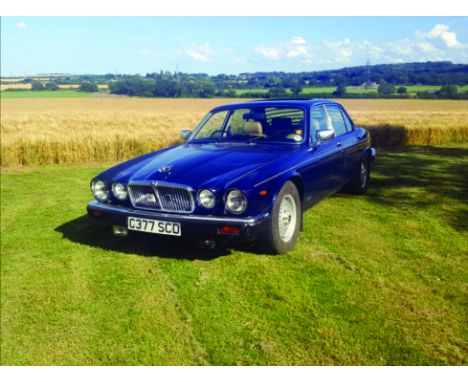
Lot 105
Yes “One owner from new” and owned by the man that bought us rear window louvres and shiny plastic hub caps, things that were the absolute “must have” back in the 70’s. Just about every one over 40 would have owned an “Autoplas” product at some point.Being an ardent lover of Jaguar cars the owner of this one, now sadly passed away, would buy a jag, keep it until he wanted another or a new model XJ came out then buy that, he never sold the old ones, just parked them up in his garages!This is what happened to this lovely XJ12 Saloon, it was driven into the garage 22 odd years ago and that was where it stayed until now. It was like a time warp, exactly as he left it!With only 64,890 miles on the clock not much will be worn out and the engine runs. The body work has survived well with very little rust just various “storage marks” Inside, apart from the drivers foot well that has its original floor mat the other 3 foot wells have expensive and very thick shag pile over mats, these have been there from new so you can imagine what the carpets are like underneath, new! The leather needs no more than a deep clean and feed. The electric windows are temperamental, sticky switches probably. In the boot is the original Jaguar tool kit in its box plus the jack and original owners book, there is even a Jaguar map showing where Jaguar dealers are round the country (For our younger visitors, a map is like a fold out Sat Nav. Sorry couldn’t resist).This is a superb opportunity for someone, yes it needs recommissioning but it’s a One Owner low mileage 1986 5.3 V12 XJ12 and even better, it still has its “Auto-plas” rear window louvre in place!!


Lot 2123
'A Narrative of Missionary Enterprises in the South Sea Islands', by John Williams, with map and engravings by G Baxter, pub London 1838, cloth gilt, 'Memoirs of The Life of the Rev. John Williams, Missionary to Polynesia' by Ebenezer Prout, pub London 1843 half calf, two vols Condition Report Click here for further images, condition, auction times & delivery costs

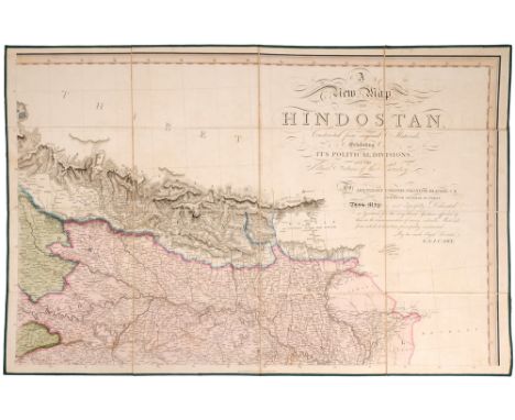
Lot 149
Cary, G & J. A Collection of 5 of 6 Maps of India / Hindoostan, 1824. London: G & J. Cary, 1824. First Edition. 96 x 52cm Approx. (38 x 21 Inches Approx.). The collection of 5 canvas backed folding maps in original green box comprise: (1) Lacks map of North West of the country; (2) A New map of Hindoostan (3) Area to the West including Bombay and areas coloured according to which Moosulam Chiefs Reign; (4) Area adjacent to the Bay of Bengal; (5) The lower portion of India with the sea and part of North Ceylon; (6) Overland Map of the countries between India and Europe. Scarce. 38 by 21in. (96.5 by 53.3cm)


Lot 138
1757 Map of part of North America, by Gilles Robert de Vaugondy. A large, hand-coloured, engraved map, Partie de l`Amerique Septentrionale, qui Comprend le Cours De l`Ohio, la Nlle. Angleterre, la Nlle. York, le New Jersey, la Pensylvanie, le Maryland la Virginie, la Caroline. Map of the colonies between the Ohio and Mississippi rivers and the Atlantic with an inset at upper left that continues the main map from Cape Fear south through the Carolinas and Georgia to F. St. Georges. 19.50 by 24.50in. (49.5 by 62.2cm) MAPS

Lot 114
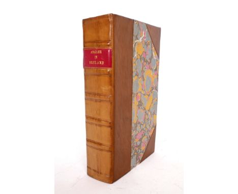
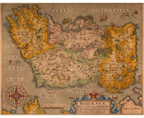
1607-1800 Collection of eight early printed maps of Ireland and the British Isles. An outline coloured, engraved map of Ireland, oriented westwards, by William Camden, Hiberniae Ireland Anglis Yverdon, 1607; an engraved map of Ireland, by Robert Morden from Camden's Britannia, 1695, with Newry spelt correctly; a coloured engraved map of Ireland by Richard Blome, A Map of the Kingdome of Ireland, c.1700; two18th century maps of Ireland by John Cary and Samuel Dunn; Britain and Ireland by Rapin and a plan of the Town of Wexford by Peter Fannin, Master in the Navy, 1800, with key showing the 'houses destroyed by the rebels in June 1798'. unframed (8) The largest sheet 25 by 18in. (63.5 by 45.7cm)

Lot 127
Circa 1760 Map of Ireland, by John Rocque The Kingdom of Ireland Divided into Provinces Counties and Baronies. Showing the Archbishopricks, Bishopricks, Cities, Boroughs, Market Towns, Villages, Barracks, Mountains, Lakes, Bogs, Rivers, Bridges, Ferries, Passes...". With large decorative title cartouche in top left corner and inset map of the sea coasts of Great Britain and Ireland bottom right. A very large engraved map, printed on 4 sheets, In two sections North & South. Colouring to the county and provincial borders. Unframed. The larger (Southern) section 25.75 by 39.50in. (65.4 by 100.3cm) MAPS

Lot 142
1808 Map of the North Eastern Seaboard of the United States. A hand-coloured engraved map, A New Map of Part of the United States of North America, containing those of New York, Vermont, New Hampshire, Massachusetts, Connecticut, Rhode Island, Pennsylvania, New Jersey, Delaware, Maryland and Virginia from the latest Authorities. by John Cary, Published by New Universal Atlas. 1808. 20.50 by 23in. (52.1 by 58.4cm) MAPS

Lot 117
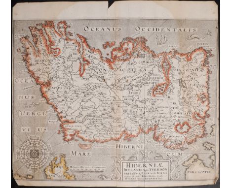
17th century, Hiberniae, Map of Ireland by William Camden Hiberniae Ireland Anglis Yvrndon Britannis Erin incolis... A hand-coloured, engraved map of Ireland, oriented to the west, strapwork cartouche and compass rose, engraved by William Hole and published in the seventh edition of Camden's 'Britannia', 1610, framed. 10.75 by 13.50in. (27.3 by 34.3cm)


Lot 133
1854 Wyld's pocket map of Ireland. Wyld (James), engraved map with contemporary outline colouring, A Map of Ireland divided into Provinces and Counties shewing the Great and the Cross Roads with the distances of the Principal Towns from Dublin. Also the Steam communications from the Out Ports and the average time of passage, the 24 sections laid on linen, in slip-case,1854. 31 by 23in. (78.7 by 58.4cm)


Lot 1187
Kingdon-Ward (Francis); 'The Mystery Rivers of Tibet', FIRST EDITION, pub., Seeley Service, London, 1923, in mustard coloured cloth boards, including fold out map, together with Kingdon-ward (Francis); 'From China to Hkamti Long', first edition, pub. Edward Arnold, London 1924, with dust jacket and fold out map, and Kingdon-ward (Francis); 'In Farthest Burma', first edition, pub., Seeley, Service & Co., London, 1921, cloth bound boards (3)


Lot 1185
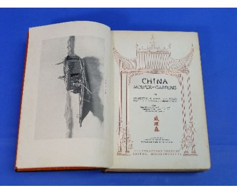
Wilson (Ernest); 'China, Mother of Gardens' FIRST EDITION, pub. The Stratford Company, Boston, 1929, signed on the half-title page by the author, in cloth boards, with fold out map at back, together with Kingdon-Ward (Francis); 'The Romance of Plant Hunting, first edition, pub. Edward Arnold, London, 1924 and two first edition copies of Kingdon-Ward (Francis); 'Plant Hunting on the edge of the World', pub Victor Gollancz, London, 1930, one copy having been rebound (4)

Lot 1167
Winston Churchill; a photograph signed ("W.S. Churchill") on the mount, showing Churchill at the Cabinet Table, half length, facing the camera, some silvering at edges, image size 7½in x 6in (19cm x 15.25cm), overmounted and framed, together with two pictures of Churchill's W.W.2 map room (3)


Lot 25
JOHN LLOYD 'The Great Forest of Brecknock', London 1905. Large 4to. Very large folding map and 9 plates, in fine publishers half-crimson Morocco binding together with Coxe's 'Tour in Monmouthshire', Brecon 1904. One volume reprint with extra materials added, large 4to in fine red half calf binding


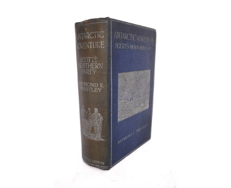
Lot 1069
CHURCHILL Winston, L.S. Sir, The Story of the Malakand Field Force, London 1898, first edition, 8vo green cloth, gilt titling, black endpapers, no errata slip before first map, 6 maps including 2 folding, no inscriptions, slight foxing to prelims (1) Condition Report / Extra Information Binding is firm.Rear endpapers good.


Lot 103
'Scarborough', 'Malton' and 'Ayton Forge', three 18th century engravings hand coloured pub.J Walker, London and 'North Riding of Yorkshire', 19th century map by J Neele pub. Fullarton max 20cm x 25cm (4) Condition Report Click here for further images, condition, auction times & delivery costs


Lot 1108
Bartholomew's Maps-Vintage Cloth-backed 'Half inch' maps- Oxford, Merseyside, Cornwall, Argyll, Kent, Herts and Bucks, Peck District, English Lakes, Warwickshire, Sussex, plus, a quarter inch map of Cork and Killarney, these maps are so attractive that they would look well framed in any office or den.
-
109182 item(s)/page