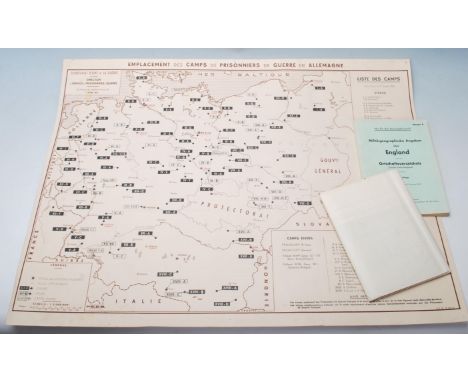

3 Original World War Two items: (1) Emplacement des Camps de Prisonniers de Guerre en Allemagne. POW (Prisoners of War) Camp Poster 1942. A French poster published by the Secretariat d’etat a la Guerre, Lyon October 1942. On stiff paper size 73 by 54 cm. Scale 1:2,000.000. With a key to Stalag, Oflag and to other types of camp; to important towns and to military headquarters. Includes a list of over 50 camps shown on the map which are divided into various categories. Remains of pin holes in the corners but otherwise in Good to VG condition. (2) Military and Geographical Details,England. German briefing material from World War Two, published by the German General Staff, Berlin in August 1941, headed "not for distribution". A gazetteer of English and Welsh towns & villages. Lists population, principal industries, railway stations and occupations plus details of location. 166pp. Size 8" by 6", VG condition. (3) A large map of Great Britain and Ireland, published by the German General Staff, Berlin August 1941. On paper which has been folded, size 147 by 92 cm. Scale 1:1,000,000. Full colour. Shows all towns, roads, rivers, heights etc. Includes an inset map of the Shetlands. Includes the instruction that this is not for public distribution. Map covers all of the British Isles and has contemporary detail on Ireland and Scotland not available in the book. VG condition.
We found 109182 price guide item(s) matching your search
There are 109182 lots that match your search criteria. Subscribe now to get instant access to the full price guide service.
Click here to subscribe- List
- Grid
-
109182 item(s)/page


A WWII four medal group awarded to Pte. TW Jones, (Liverpool) 3460729, 6th Battalion, K.O.R.R H.Q.COY, Signals to include 1939-45 Star, Burma Star, Defence Medal, War Medal 1939-45 together with a Special Forces embroidered Burma Chindits cloth badge with accompanying printed letter dated 1944, two Kings Regiment slip-on titles, a booklet titled 'History of The King's Own Royal Regiment (Lancaster) IV', a silk handkerchief printed with a central map of Burma and an ROAB medal in case. CONDITION REPORT Medals belonged to Vendors father.

Eastern Telegraph Company Limited 1889 Varnished wood Letter Opener/Page Turner. 335 x 35 mm. Maps printed on both sides, with calendar for 1889 in gold on black on both sides of the finial. "This desk accessory, designed for use as a map page turner or letter opener. The Company was based in London and were part of a network creating communication routes around the UK and across the Atlantic in the late 1800s. Some damage to the varnished map section.

Victorian 'The United Asbestos Co., Limited' 1889 Varnished wood Letter Opener/Page Turner. 335 x 35 mm. Advertising many Products such as Fibre, Yarn, Asbestos and Rubber Sheet etc., with calendar for 1889 in gold on black on both sides of the finial. "This desk accessory, designed for use as a map page turner or letter opener. The Company formed in 1880 by amalgamation. In excellent condition with no lose of the varnished wood advertising sections.


A SELECTION OF ITEMS, to include a canteen of 'Rustless Nickel Silver' cutlery such as knives, forks, tablespoons and teaspoons, a boxed set of three chrome plated fish forks and knives, a box set of three 'Sipelia Cutlery' knives, forks and teaspoons, a boxed set of six chrome plated teaspoons with figures to the handles, a cased set of EPNS pickle forks, teaspoons and sugar tongs, together with a small quantity of costume jewellery such as beaded necklaces, imitation pearl necklace and brooches, a white metal cigarette case, of engine turn design and engraved with a map of England to the front, etc
A BOX OF SUNDRY ITEMS to include a map of Russia in Turkey - The Seat of War, a French map retailed by Stanford of Charing Cross, produced by August Logerot 1854, twenty five cloth bound sheets, Whitefriars Nailhead vase in Kingfisher - chipped, Art Deco chrome table lamp, approximate height 27cm excluding bulb fitting, navigators hardwood ruler with brass fittings, woven cotton nightshirt, stamp album etc


LIVERPOOL: LARGE-SCALE MAP: BENNISON, Jonathan: A Map of the Town and Port of Liverpool, with their Environs including Seacomb, Woodside, Birkenhead, Tranmere &c., large finely hand-coloured engraved map. J. Dower after Bennison. Liverpool, J. Bennison, 1835. Four linen backed folding sections, each in 16 parts and measuring 90 x 65 cms. Cloth slipcase with Morocco label.Condition report: Foxed and discoloured. Marbled boards inscribed in pen, external case with knocks to corners and faded. Please view additional images.
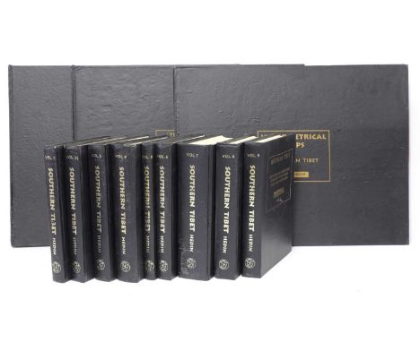
The Christopher Dyment Collection: HEDIN, Sven: Southern Tibet. Discoveries in Former Times compared with my own Researches in 1906 - 1908 (9 text volumes + 3 map volumes - complete set. Delhi, B. R. Publishing Corporation, 1991-92. Folio, original cloth; little rubbed. (12) "Christopher Dyment (1939-2016): After reading Law at Cambridge and alongside with his career at the Law Commission he spent time travelling in east Asia and the Himalayan areas, influence by Tibetan Buddhism; and also concentrating on music. Christopher wrote numerous articles about historical conductors and also one book on Felix Weingartner, one on Toscanini in Britain and one on conducting the Brahms Symphonies."


A map of Essex by Norden and Speede inscribed: 'Essex Divided into Hundreds with the Most Ancient and fayre Towne Colchester described........Anno 1610' sold by G Humble. This map dating from later in 17th century. Coloured. Plate mark obscured by mount. 39.5 x 52.2 visible imageCondition report: Central crease worn, no plate mark visible, evidence of text on back of sheet. Modern gilt frame


MAPS & ATLASES: 1- Up and Down the River. Bennet's Map & ABC Guide to the River Thames from Oxford to Gravesend with Useful Notes for Boating & Angling. no date, c1895. PP; 20, plus folding colour map (slight wear to first fold) in the original pictorial covers and adverts. 2- Gall & Inglis: Map of 60 miles west of London. nd, folding colour linen backed in original covers; 3- Walker’s map of Kent. nd, c1840 folding coloured in original covers (upper detached); 4- Harmsworth Atlas Motor Map of The British Isles and Central Europe & Algeria. nd, c1920. two folding colour maps each in an envelope & both in a slipcase; 5- Gardiner’s School Atlas of English History. 1891. Colour maps. Original cloth; VG; 6- Historic Towns, vol. 1. 1969, dw. (6)
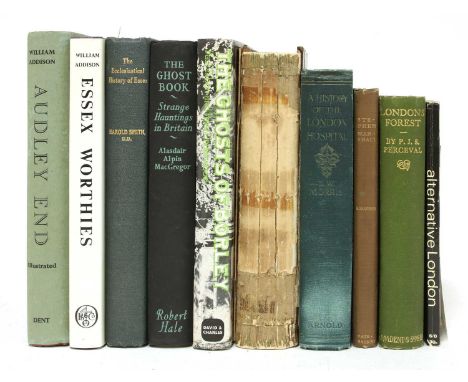
London/Essex/Haunting/Etc: 1- Grieve, H: The Great Tide. Story of the 1953 Flood Disaster in Essex. 1959, 1st. dw. 4to. ill. plus folding map in pocket; 2- Puleston, JH & JE Price: Roman Antiquities Recently Discovered on the Site of the National Safe Deposit Company s Premises, Mansion House, London. 1873, 1st. TP Inscribed: “Henry Mandley, with the Architects kind regards” (possibly John Whichcord). 4to. frontis, double page plan plus 14 plates; 3- Ferries, K G: Essex Windmills. Vol. 1-3, 1981-84, 1st. dws. 4to. Fine; 4- Thornbury, W: Haunted London. 1865, 1st. half leather; lacking spine; 5- Longe, A: The Old Night-Watchman, The Ghost of Spixworth Hall. 1950, 1st. Inscribed from the author; 6- Underwood & Tabori: Ghosts of Borley. Annals of the Haunted Rectory. 1973, 1st. dw. VG; Plus 19 others. (25)

MAP: BRYANT’S MAP of the county of HERTFORD from actual survey in the years 1820 & 1821. Published by Bryant, April 10, 1822. Two parts, North & South, each in 18 sections, linen backed and folding, 165 X 67 cms each (165 X 134cms.). Housed in a specially made clamshell box with leather label; RH Johnston’s bookplates.
![NOLLI, Giovanni Battista: NUOVA PIANTA DI ROMA DATA IL LUCE DA GIAMBATTISTA NOLLI 1748. [ROMA]. Roma, 1748. Folio, PP: 2 doub](https://cdn.globalauctionplatform.com/a23bd2a8-750c-462c-82b2-ac5c0106b0fe/7d57608c-d9c2-4e8b-a611-ac5d00be3ae1/468x382.jpg)
NOLLI, Giovanni Battista: NUOVA PIANTA DI ROMA DATA IL LUCE DA GIAMBATTISTA NOLLI 1748. [ROMA]. Roma, 1748. Folio, PP: 2 double page plans dated 1748 & 1773, followed by engraved title page, engraved "Avviso al lettore", an index on 8 engraved sheets, followed by: the Map of Rome on 12 double-page sheets including vignettes of allegorical figures after Stefano Pozzi together with Rome's monuments, and the dedication to Pope Benedetto XIV on the base of a column, the map set in an elaborate rococo border. This was the first modern map of Rome based on scientific principles. Cont. leather backed boards, rubbed and torn. Text & Maps clean. {The finest of the eighteenth-century plans of Rome and the first plan of the city based upon geodetic principles. With Rocque's plan of London and Bretez's plan of Paris, Nolli's plan ranks as one of the greatest eighteenth-century plans of any European city}. {{The double pages measure: 73 x 49cms. and the actual image on each of the 12 double page plans measure: 68 x 43cms. each}}.

Armstrong, Mostyn John: An Actual Survey of the Great Post-Roads Between London and Edinburgh. For the Author, 1776, 1st. edn. PP: Frontis General Map, Engraved title page with vignette, 8, 1-44, 44 strip maps (several hand-coloured in outline), (i)Publishers Adv. Original marbled boards with later leather spine gilt lettered. Worm damage to bottom corners; 2 bookplates.

PARK, Mungo: 1- Travels in the Interior Districts of Africa Performed under the Direction and Patronage of the African Association, in the Years 1795, 1796, and 1797. W. Bulmer, London, 1799, 1st. Edn. with list of subscribers. All plates and maps present. PP: xxviii (without half title), 372, xcii (Appendix), (vi) postscript, etc. Later half leather. Damp staining mainly affecting the first 20 pages and last 100; 2- Journal of a Mission to the Interior of Africa in the Year 1805.. John Murray, 1815, 1st. Edn. 4to. Large folding map. PP: (x), 219, (I)b, cxxx, (I). Later matching binding to above. Damp staining to first 10 pages and bottom corner of the last 18 pages. (2)

Grose, Francis: The antiquities of England and Wales, IN 8 Volumes. S. Hooper.., no date, New edition, (1787) the plates are dated 1781-1787. 4to. Illustrated with 8 Engraved titles vignettes, Large folding hand-coloured Map, 635 plates (including portrait of author and plans), Plus 56 half page county maps. Cont. full leather with gilt tooling and later raised spines with gilt lettering and labels. The armorial bookplate of Horatio Noble Pym to front pastedown ( He was a confidential solicitor, book collector and the editor of the best-selling private journal of the Quaker writer, Caroline Fox: Memories of Old Friends, published in 1881). Very clean set. (8)

ATLAS: MACREDIE, Alex (Publisher): ATLAS MINIMA: Comprehended in 30 Maps. Drawn & Engraved by W. Murphy. Edinburgh, no date (1825)- the index page with 1824 watermark. PP: Title, Index, plus 30 hand-coloured maps (except for South America, which has very faint colouring). Cont. half leather & marbled boards; rubbed; name to front pastedown and lacking the blank front endpaper; small ink stain to the last map (S. America).

Dufour, Auguste Henri: Carte Administrative, Physique et Routiere de l' Espagne et du Portugal. Paris, Bulla et Jouy, 1856. Folding, coloured linen backed in 16 sections, surrounded with 36 views; (131 x 97cms). Housed in a marbled fold-over card and matching slipcase (missing a part of one side). The linen backing a little browned, but the map is very clean.

ILLUSTRATED BOOKS, ETC: 1- Dulac, E; Poe, E A: The Bell, Hodder & Stoughton, no date, c1912. with 28 colour plates. 4to. original highly gilt decorated covers; VG; 2- Dulac, E: Rubaiyat of Omar Khayyam. Hodder & Stoughton, nd, 4to. 20 tipped-in colour plates. Orig. gilt pictorial cloth, a little warped; 3- Rackham, A: Midsummer Night's Dream. Heinemann, 1911, 2nd. impr. with tipped-in colour plates; Orig. gilt cloth, rubbed; 4- Rackham; Irving: Rip Van Winkle, 1908, repr. with tipped-in colour plates. orig. cloth. rebacked; rubbed & blotched; 5- Hopkins, E; Stern: Sentimental Journey through France & Italy. William & Norgate, 1910, De Luxe edn. Limited: #391/500 SIGNED by illustrator Orig. white cloth gilt; Plus: T E Lawrence: Seven Pillars of Wisdom, 1935, 1st. trade edn. covers stained & small stain to title; Revolt in the Desert. 1927, 3rd. impr. covers stained and map at the end torn off, but complete. (7)

ORDNANCE SURVEY MAPS: Ministry of Transport: Road Map of England & Wales. ½ inch to mile, 39 out of 40 linen backed folding coloured maps (lacking no. 26, Glamorgan). Plus two index reference books: Piggott, son, & weathers, Manchester, 1923 & 1925 editions; all housed in the original full leather case.
Keough, Pat and Rosemarie: ANTARCTICA: (Explorer Series, Volume I). Nahanni Productions, Salt Spring Island. 2002-7. Limited edition, No. 12 of 950 plus 50 proof copies, Signed by both Pat & Rosemarie, Also signed by Queen Noor of Jordan. 336 pages, introductory text, map, and 330 full-colour photographs and 15 duotones. Oblong folio, full grey blindstamped morocco; housed in custom-made clamshell box, stand and base. A FINE COPY. NOTE: (Pat and Rosemarie Keough were awarded the "Nature Photographer of the Year" and "World's Best Photography Book" by the International Photography Awards Committee. Antarctica also won the Benjamin Franklin Award).
'A New Map Of Ireland From The Latest Observations', by John Senex, inscribed to the Rt. Hon. Simon Lord Louat, 1720, with hand-coloured highlights, 59 x 48cm , framed and 'The Decendants of Cateal Crovederg O' Connor, King of Connacht', a printed family tree published by McGlashan & Gill, Dublin A.D. 1861 64 x 48cm framed (2)Condition report: Map - light foxing and discolouration. Family Tree - with creases and discolouration.
-
109182 item(s)/page