We found 109198 price guide item(s) matching your search
There are 109198 lots that match your search criteria. Subscribe now to get instant access to the full price guide service.
Click here to subscribe- List
- Grid
-
109198 item(s)/page


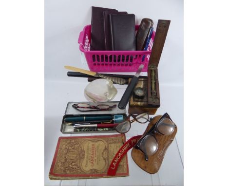
Lot 50
Gentleman's Lot, comprising rosewood and ebony rulers, ostrich skin glasses case, three pairs of tortoiseshell style glasses, compass, Coutts leatherette banking books, coin scales and Ordnance Survey map of Lancaster & District and four fountain pens and a French glass paperweight in the form of a toad.

Lot 1385
Military Interest WWII German Classified Books and Maps "Militärgeographische Einzelangaben über England" Preparing to invade Britain, the German military preparations included the production of a series of military/geographical assessments, showing what might be found by those arriving. Lot 1385 contains large scale town plans marked with strategic locations, a book of photographs and a quarter-inch map of the area, the folder titled “Militärgeographische Einzelangaben über England” (Maps of England showing features of military significance) Also four accompanying paperback publications.


Lot 405
A Complete Set of 40 x Sterling Silver Medals 'The Ancient Counties of England,' issued by the Birmingham Mint 1975 to commemorate the boundary changes to English counties 31 March 1974; the obvs depict a building or other well-known landmark associated with each county; the set also includes a reproduction map of England dated 1635 & a booklet with detailed historical notes on each county; average weight of each medal 40.6g, in fitted wooden CofI, BU''


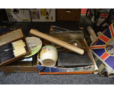
Lot 153
Advertisement - a Wills's 'Gold Flake' promotional card reward for collecting 48 sections; another; a portfolio of countryside related printers mock up copies of various artists; a Prince Charles investiture and printers catalogue; an early 20th Century ordinance survey map of a geological survey of Buxton and surrounding areas; six various glass storage jars; an Edwardian glass decanter; a Royal Doulton changing Georges decorative plates; plated ware, etc


Lot 318
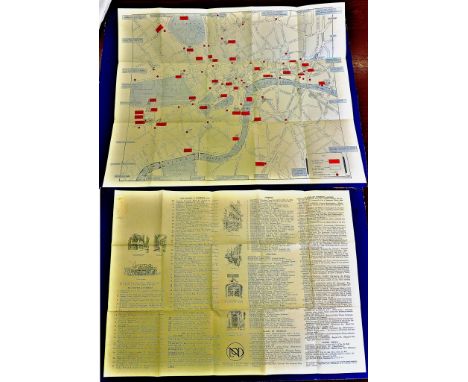
Box of assorted books etc to include; Clive Lloyd trivia match programme, pictoral map of London, Hidden towns, Mayflower construction kit, Johnsons Dictionary, Dragons dream books, The Old Vic theatre company a tour of Australia and New Zealand, various ephemera, French police programme etc. (B.P. 24% incl. VAT)


Lot 57
A sixteenth century coloured engraving map of Paris, showing the city and all its districts with the river Seine running through the middle with figures in period dress to the lower left corner and a framed description of the map to the lower right, mounted in a card frame, 33 cm high 48 cm wide


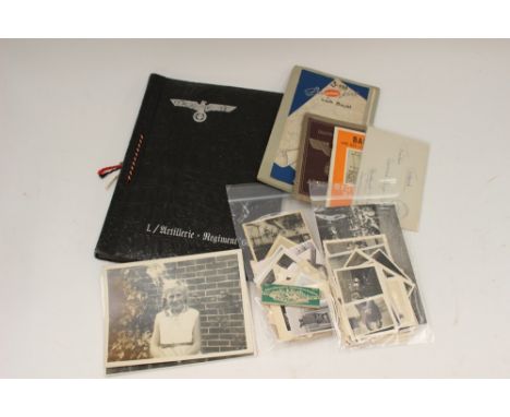
Lot 663
WW2 Third Reich paperwork and photograph collection: empty black cover photo album with eagle to cover for I/Artillery Regt 60: Map "Die Lubecker Bucht": Feldpost letter 03392: Pocket photo book of Bad Tolz: Arbeitsbuch with entries from 1944 to 1947: packet of "Efka" cigarette papers: thirty female themed photos of BDM/RADjW/DRK interest: over fifty mixed Heer/Luftwaffe photos.


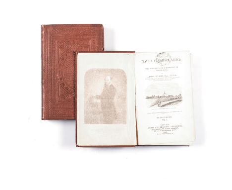
Lot 86
PHILIP, THE REV JOHN RESEARCHES IN SOUTH AFRICA: JOURNALS OF THE AUTHOR'S TRAVELS IN THE INTERIOR, 2 VOLS London: James Duncan, 1828 First edition. Information concerning the Civil, Moral and Religious Condition of the Native Tribes and the influence of Christianity in Promoting Civilization. Half leather, sellotape repair to folds of map which have not penetrated and ditto to front hinge split in both volumes. With handwritten notes of Dr Philip in italic script prepared in 1968. (2)
Lot 77
McLeod, Lyons TRAVELS IN EASTERN AFRICA WITH THE NARRATIVE OF A RESIDENCE IN MOZAMBIQUE, 2 VOLS London: Hurst and Blackett Publishers, 1860 First edition. Fold-out map and portrait of author as frontis to Vol. 1 and lithograph. View of Mozambique as frontis to Vol. 2. Blindstamped brown cloth, internal hinge split to Vol. 1. British and Foreign Anti-Slavery Society Stamp on title page. (2)


Lot 71
Le Vaillant NEW TRAVELS INTO PARTS OF AFRICA BY THE WAY OF THE CAPE OF GOOD HOPE IN THE YEARS 1783, 84 AND 85, 3 VOLS London: C. G. and J. Robinson, 1796 Second edition. 22 copper plates and map with old linen repairs to reverse of map folds. Fold-outs and maps with foxing, and very slight scattered foxing throughout, inscription on front free endpapers. Rebound in half leather, possibly 80 years ago. Viewing of this lot recommended. (3)

Lot 41
Alexander, James E. Sir AN EXPEDITION OF DISCOVERY INTO THE INTERIOR OF AFRICA THROUGH THE HITHERTO UNDESCRIBED COUNTRIES OF GREAT NAMAQUAS, BOSCHMANS AND HILL DAMARAS, 2 VOLS London: Henry Colburn Publisher, 1838 First edition. Frontis and 14 two-tone illustrations and folding map. Half leather, pebbled cloth boards, foliated highly decorated banded spine, marbled endpapers. Endpaper to Vol. 1 rubbed. A good set. (2)

Lot 57
de la Caille, M. P. Abbe JOURNAL HISTORIQUE DU VOYAGE FACT AU CAP DE BONNE-ESPERANCE Paris: Chez Guillyn Libraire, 1763 First edition. Map of the Cape of Good Hope and other engravings/decorations throughout. Marbled endpapers, full leather, the original spine - damaged, has been applied to a new leather spine, leather corners worn.

Lot 97
VOIGT, J.C. FIFTY YEARS OF THE HISTORY OF THE REPUBLIC IN SOUTH AFRICA 1795 - 1845, 2 VOLS London: T. Fisher Unwin, 1899 First edition. Folding map Vol. 1. Full navy new calf binding, new endpapers, foliated highly decorated spine with red titled sections, pre title and title page with skilfully filled wood worm holes to both volumes and discolouration. Interior good and clean. (2)

Lot 60
Fleming, Rev Francis SOUTHERN AFRICA: A GEOGRAPHY AND NATURAL HISTORY OF THE COUNTRY, COLONIES AND INHABITANTS OF THE CAPE OF GOOD HOPE TO ANGOLA London: Arthur Hall Virtue, 1856 First edition. With map. Original blindstamped pictorial cloth with gold image on front cover board, top of spine edge frittered.


-
109198 item(s)/page