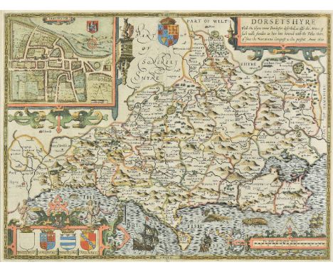
*Mercator (Gerard, and Hondius, Jodocus). Cornubia, Devonia, Somersetus, Dorcestria, Wiltonia, Glocestria..., Warwicum, Northamtonia, Huntingdonia, Cantabrigia, Suffolcia, Oxonium, Buckinghamia..., Eboracum, Lincolnia, Derbia, Staffordia, Notinghamia, Lecestria, Rutlandia et Norfolcia, Westmorlandia, Lancastria, Cestria, Caernarvan, Denbigh, Flint..., [and] Northumbria, Cumberlandia et Dunelmensis episcopatus, [1613 or later], together five hand coloured engraved regional maps of England and Wales, each with an elaborate strapwork cartouche, each approximately 375 x 475 mm, Latin text on verso, mounted, framed and double glazed, together with Morden (Robert), Nottinghamshire [and] Shropshire, [1695 or later], two uncoloured engraved maps, Shropshire toned overall, each approximately 360 x 415 mm, mounted, framed and glazed, with Van der Aa (Pieter), La France suivant las nouvelles observations, Leiden, circa 1720, uncoloured engraved map, old folds, slight overall toning, 225 x 300 mm. mounted, framed and glazed, plus a reproduction of Blaeu's map of the British isles, framed and glazed (9)


![*Flintshire. Speed (John), Flint-Shire, published Thomas Bassett & Richard Chiswell, [1676], hand coloured engraved map,](https://cdn.globalauctionplatform.com/a3ebd08e-0d61-45d7-b5d0-a9f500c017ad/fd6b5e4b-724d-4e65-b55d-a9fc00e162fc/468x382.jpg)

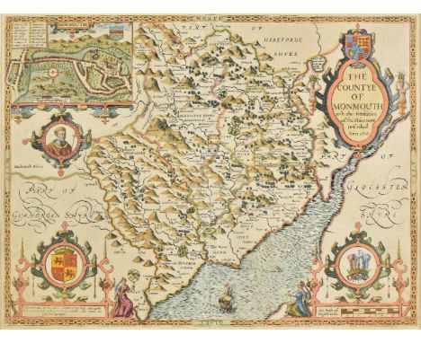
![*Hampshire. Speed (John), Hantshire described and devided, published Thomas Bassett & Richard Chiswell, [1676], hand colo](https://cdn.globalauctionplatform.com/a3ebd08e-0d61-45d7-b5d0-a9f500c017ad/f8840542-f389-41b7-a463-a9fc00e164e7/468x382.jpg)

![Holy Land. Blaeu (Willem Jans Zoon), Terra Sancta quae in sacris Terra Promissionis olim Palestina, Amsterdam 1629 [or later]](https://cdn.globalauctionplatform.com/a3ebd08e-0d61-45d7-b5d0-a9f500c017ad/d9e4a5b9-896b-4074-ac10-a9fc00e1667f/468x382.jpg)


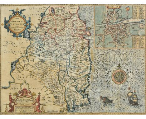
![*Ireland. Speed (John), The Province of Mounster, 1st edition, published John Sudbury & George Humble, [1611], hand colou](https://cdn.globalauctionplatform.com/a3ebd08e-0d61-45d7-b5d0-a9f500c017ad/52281b08-9384-4787-b693-a9fc00e1692a/468x382.jpg)

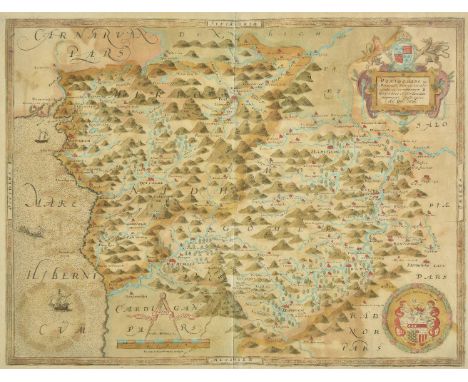
![*Lancashire. Saxton (Christopher & Hole G.), Lancastriae comitatus palatinus olim pars Brigantum, 1st edition, [1607], ha](https://cdn.globalauctionplatform.com/a3ebd08e-0d61-45d7-b5d0-a9f500c017ad/9f64529f-eb2e-4f65-a503-a9fc00e16b9f/468x382.jpg)


![Morocco. Ortelius (Abraham), Fessae et Marocchi regna Africae celeberr describebat, [1606], hand coloured engraved map, inset](https://cdn.globalauctionplatform.com/a3ebd08e-0d61-45d7-b5d0-a9f500c017ad/a0ba1270-094f-449c-beec-a9fc00e170a6/468x382.jpg)

![North Yorkshire. Hulsberg (T. & Gale Roger), Richmondiae comitatus et Alvertunae Schira, [1722], uncoloured engraved map](https://cdn.globalauctionplatform.com/a3ebd08e-0d61-45d7-b5d0-a9f500c017ad/6d072f0d-126d-4e91-ae8a-a9fc00e171b2/468x382.jpg)

![Ogilby (John). The road from Bristol com. Glos to West Chester, [1675], hand coloured engraved strip road map, 355 x 445 mm T](https://cdn.globalauctionplatform.com/a3ebd08e-0d61-45d7-b5d0-a9f500c017ad/2a8bbe06-9d6d-454b-afb2-a9fc00e172ab/468x382.jpg)
![Ogilby (John). The road from London to Holy-head co Anglesey North Wales..., [1678], uncoloured engraved strip road map, larg](https://cdn.globalauctionplatform.com/a3ebd08e-0d61-45d7-b5d0-a9f500c017ad/0167805e-b732-4461-9749-a9fc00e17332/468x382.jpg)


![Scotland. Hole (G.), Scotia regnum, [1610 or later], hand coloured engraved map, strapwork cartouche and large compass rose,](https://cdn.globalauctionplatform.com/a3ebd08e-0d61-45d7-b5d0-a9f500c017ad/e3f2d84c-2bec-4ce0-a7e8-a9fc00e175ab/468x382.jpg)


