We found 109198 price guide item(s) matching your search
There are 109198 lots that match your search criteria. Subscribe now to get instant access to the full price guide service.
Click here to subscribe- List
- Grid
-
109198 item(s)/page


Lot 109
A mid 18th century plan, coloured engravings, for the Langborn Ward and Candlewick Ward, London, with their divisions into Parishes according to a new survey inscribed to Sir Joseph Hankey and to Sir Charles Asgil, Knight, later framed and an 19th century map of the Parish of St Martin's in the Fields, framed


Lot 577
Rowe (R) Shropshire, engraving, 46 x 36cm (SH) together with a map of Shropshire bu S.Hall, a plan of the Ellesmere Canal by I Muslow, a map of Shropshire by J.Archer, a map of Shropshire by R.Ramble and a map of the stagecoach routes in Shropshire and the surrounding counties by laurie and Whittle, all unframed, various sizes (6)


Lot 702
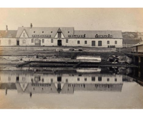
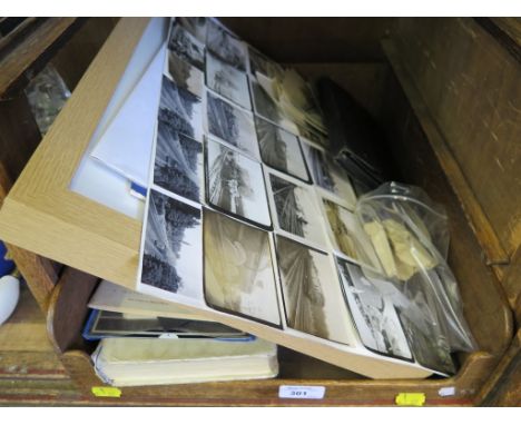
FALKLAND ISLANDS. TWO PHOTOGRAPH ALBUMS OF THE VERY REVEREND LOWTHER EDWARD BRANDON, MA (1846-1937) AND HIS WIFE JACQUELINE REBECCA CORDELIA BRANDON, NEE JAMESON (1855-1946), 1906-07 one hundred and twenty four c 7 x 10cm sepia tinted and other silver prints including Port Stanley, Government House, the Harbour, shipping, choir picnic, Sparrow Cove, cutting peat, islands, Dean Brandon on his horse on his last tour, a shepherd's family in the Camp, David Gillow at Causeway Bay Woolshed, coast scenery, Arthur Cobb shearing sheep, George Bowles rolling up wool, Jessie Phillips retirement, Mr & Mrs Jennings, Jimmy Steele and other inhabitants, shag rookery, penguin colony and other birds, the majority captioned, both albums inscribed as gifts from Arthur Frederick Cobb (1877-1973) of Port Stanley, Christmas 1906 and May 1907, MacDonald (F C), Bishop Stirling of the Falklands, L E Bradon's copy with his signature, 1929, three illustrated souvenir booklets of views, c1900-10, a folding map, new edition backed on linen published by Edward Stanford, nd, (late 19th c), an album of snapshot photographs of India and Ceylon, c1930, miscellaneous correspondence namely letters to the Misses Nora F and Maud V Jameson, including one from Florence Brandon and another from Emeline Cadbury (Westhill, Birmigham 1948) and a Victorian hand coloured photograph of a lady, framed Lowther Brandon was appointed Colonial Chaplin to the Falkland Islands in 1877, where he served for thirty years, the last ten of which as Dean of Christchurch Cathedral, Stanley. A Church of Ireland clergyman, Brandon was energetic in his ministry and founded the first savings bank, established an abstinence society and also the Falkland Islands magazine, typesetting and printing it himself. He must have cut a distinctive figure riding tirelessly around his extensive parish, followed by a packhorse that carried his magic lantern and equipment to distant settlements. He returned to Ireland in 1907. The Misses Jameson, spinster sisters born in the 1890s, were related to Brandon's wife. Prior to retirement, Miss Nora Jameson was Secretary of the College of Nursing Club, Birmingham. The Indian photographs were almost certainly taken by her or her sister. ++A most interesting selection of unpublished images of Falkland Island life and scenery in the early 20th c. Clean and in good condition

Lot 688
GREENWOOD & CO. A MAP OF THE PRINCIPALITY OF WALES COMPRISING THE COUNTIES OF GLAMORGAN BRECON & RADNOR FROM AN ACTUAL SURVEY MADE IN THE YEARS 1826 & 1827.... engraving, ¾ inch to one mile, hand coloured, backed on linen, green cotton taped edges, gilt and blind tooled olive morocco book box, aeg (2)

Lot 689
HENRY TEESDALE & CO. A MAP OF THE COUNTY PALATINE OF CHESTER DIVIDED INTO HUNDREDS & PARISHES FROM AN ACCURATE SURVEY MADE IN THE YEARS 1828 AND 1829 BY W SWIRE AND W S HUTCHINGS LONDON engraving, ¾inch to one mile, hand coloured, backed on linen with blue cotton taped edges, gilt and blind tooled scarlet morocco book box (2)

Lot 700
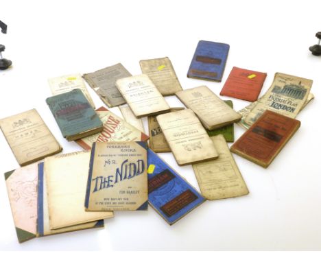
HAFOD PRESS. JOHNES (THOMAS) MEMOIRS OF JOHN LORD DE JOINVILLE GRAND SENESCHAL OF CHAMPAGNE WRITTEN BY HIMSELF.... THE WHOLE TRANSLATED BY THOMAS JOHNES ESQR 4to, two vols, engraved frontispiece, map and title vignette, half titles, original boards, 1807; Theophilus Jones, A History of the County of Brecknock, three vols, 1805 and 09, waf (5)

![FULLERTON (LIEUT COL [JA]) VIEWS IN THE HIMALAYA AND NEILGHERRY HILLS FROM DRAWINGS.... TAKEN DURING THE YEARS 1845-46-47 obl](https://cdn.globalauctionplatform.com/eb704c32-b07c-4d10-ba8c-a78a01127bc1/ee891d0a-f133-4563-87b3-c063869c8933/468x382.jpg)

Lot 228
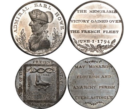
British Tokens, Eighteenth Century Tokens, Middlesex, Political and Social series, penny-sized medals in white metal (2), undated, foot trampling HONOR, serpents enclosing FR AN CE, A MAP OF THE PRESENT STATE OF FRANCE, rev. MAY MONARCHY FLOURISH etc. (DH.229); bust of Admiral Earl Howe l., rev. THE MEMORABLE VICTORY GAINED OVER THE FRENCH FLEET JUNE 1 1794 (DH. Hants. 6), first with small corrosion patch at M of MAP, and other minor imperfections, otherwise good extremely fine, struck from flawed dies, second extremely fine (2) *ex Baldwin’s vault

Lot 740
Foreign Coins and Medals, Belgian Congo, Prince Albert, his return from the Congo, bronze plaquettes, 1909 (2), by Paul Wissaert (1885-1951), naked youth greets ship, rev. map of Africa, 71.5 x 48.5mm.; by Godefroid Devreese (1861-1941), for Le Cercle Africain, naked Belgica kneels by bust of the Prince, rev. legend (in Art Nouveau lettering), 88.5 x 42mm., arched top; and a small medal, by Charles Samuel (1862-1939), 28mm. (Vancraenbroeck 95/93/94b), the first has been cleaned, generally very fine (3)
Lot 795
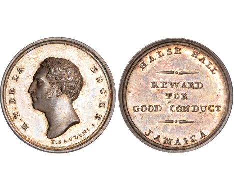
Foreign Coins and Medals, Jamaica, Clarendon, Halse Hall, Henry de la Beche, small silver Good Conduct Award, c.1823-24, by Tommaso Saulini, bust l., rev. HALSE HALL JAMAICA REWARD FOR GOOD CONDUCT, 24mm. (BDM.VI, 683; Roehrs 1554; Brandon 996), virtually mint state, extremely rare*ex Watts collection Sir Henry Thomas de la Beche, CB, FRS (1796-1855), geologist; his lifelong interest in geology was first kindled as a boy when he lived in Lyme Regis. He became a Fellow of the Geological Society of London in 1817 and was elected its president in 1847. He wrote several works on geology and was the mastermind behind the compilation of the Ordnance Survey map of Britain, begun in 1832. This medal was intended as a reward for the slaves working on the Halse Hall estate that De la Beche inherited from his father, a slave-owner. It was at Halse Hall that De La Beche wrote his geological survey of Jamaica and also published Notes on the then condition of the negroes. Neither Roehrs nor Brandon had an example of this medal in silver. See also the following lot. Whether any of these medals was actually awarded appears not to be recorded, they are nearly always found in excellent condition.


Lot 3
“The Royal Scots: On the Western Front 1917”, being No 53 of a limited edition of 1000, produced by the Regimental Museum, comprising copies of a map of the trenches, October 1917, an MID certificate signed by Churchill, and 4 other documents, well mounted and framed, 24” x 33”, with certificate on the back. VGC
Lot 116
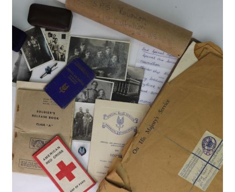
A collection of Special Air Service related material, formerly the property of Lance Corporal William James Cooke of No 1 Squadron 2nd Special Air Service Regiment, Army Number 5506493 and SAS Membership No. 1428;to include; his SAS Lapel badge, stamped to back '1428' and his SAS silver mounted brooch; medals for 1st place in Shot and 2nd place in Tug-of-War, each engraved to reverse 2nd SAS 1945 shot 1st, Tug-of-War 2nd, in their original boxes; a cross on chain Cooke was given during the War; his SAS Regimental Association Membership card with Cooke's name and number; a programme for the SAS Regiment Association Dinner, December 6th 1946 and a programme for an SAS Memorial Service December 20th 1944; W J Cooke's Soldiers Release Book, Class A; a typed letter to Next of Kin warning Mrs Cooke that her husband will not be able to write to her for some time (he was behind enemy lines); Cooke's French Resistance arm band stamped 'FF.... MEU 535'; his American Red Cross folding map of Paris; a Certificate for the Liberation of Norway, 8th May 1945, addressed to '5506493 Pte W Cooke AAC'; a quantity of black and white photographs including a group photo of No. 1 Squadron 2nd SAS Regt. Oct 1945, 2nd SAS Reunion photo, various photos taken behind enemy lines and at the front in Germany, France and Norway and time spent in the Alps training for the Liberation of Norway; also a German Identity book for a Siegfried Holzinger, who was kidnapped as part of a mission by Cooke and his fellow SAS soldiers, with approximately 16 German photographs thought to have belonged to Holzinger, many of which portray a Nazi funeral; and a Safe Conduct leaflet for a German soldier who wishes to give himself up. (qty).Illustrated

Lot 118
An Art Deco engine turned silver cigarette case, Birmingham 1933, a foliate engraved silver cigarette case, Birmingham 1918, inscribed and an Indian silver cigarette case, first half 20th century, the hinged cover engraved with a view of the Taj Mahal and the reverse with a map of India, detailed silver, 12.5 x 8.5cm, 15ozs weight combined (3).


Lot 898
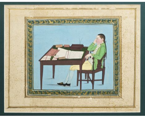
Indian School (circa 1800), gouache on paper - portrait of Jonathan Duncan (1756 - 1811), Governor of Bombay, depicted in profile, seated at his desk before a map of India, 17cm x 21cm, within foliate and gold-splash borders, framed.Provenance: From the collection of Edward Moor (1771 - 1848), British soldier and scholar. Author of 'The Hindu Pantheon' published 1810 - the first English publication detailing the Hindu gods. The original work was extensively illustrated by engravers including William Blake - the engravings taken from Indian paintings in Edward Moor's own collection. The majority of the collection was gifted to the British Museum by Mrs A. G. Moor in 1940 CONDITION REPORT Glazed frame, not examined out of the frame. Main image has some slight losses/scratches to paint surface, surface dirt and minor marks/stains. Foliate border likewise with some losses. Overlaid elements of paper in places, other line and gilt splash borders with more significant losses - possibly insect damage


Lot 663
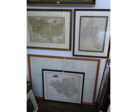
A 19th century miniature portrait of oval form, half length study of a lady in feathered hat, inscribed verso Baroness De Abercorn, 9 cm approx together with a 19th century photographic portrait of a seated lady, a small landscape etching signed M Hicks, etc., together with an acrylic painting of rocks signed Graeme Bell dated 1988, with New South Wales details verso, a signed limited edition etching of a Cornish fishing harbour by Graham Barry Cliverd and a coloured map of Hertfordshire after Robert Morden, all framed.


-
109198 item(s)/page