We found 109198 price guide item(s) matching your search

Refine your search

Year

Filter by Price Range
  • List
  • Grid
  • 109198 item(s)
    /page

Lot 2209

Wotton (H), Reliquiae Wottonianae, London 1651, printed by T Maxey for R Marriot et al and other small bindings, 17th to 19th century, including Valerii, Martialis Epigrammata, Amsterdam 1645, Joannem Janssonium, Almanac de Gotha, 1782, Debrett's, Tristram Shandy, Swift's Works, Hudibras, Candide, The Royal Kalendar 1800, etc., together with Mackenzie Wallace, Russia, 1877, Cassell, Petter & Galpin, 2 vols, folding map, tan half calf with marbled boards (37)

Lot 2246

Hartshorne (Anna C), Japan and Her People, Philadelphia 1902, Henry T Coates, 2 vols, illustrated, gilt-tooled blue cloth with flying cranes to front, Vol II with folding map, together with Wright Mabie (H), Japan Today and Tomorrow, New York, 1914, Macmillan (3)

Lot 2408

Theodorus Dankerum, coloured engraving, Map of the Turcici Imperii, 50 x 58cm

Lot 350

FRAMED & SIGNED CELTIC F.C. STRIP & A FRAMED MAP DISPLAY

Lot 227

TALISKER 10 YEAR OLD SINGLE MALT SCOTCH WHISKY, 70cl, 45% vol., OLD PRESENTATION, BOXED, TALISKER 10 YEAR OLD, MAP LABEL, 70cl, 45.8% vol. AND A TALISKER MAP LABEL, MINIATURE, 5cl [3]

Lot 138

A collection of pictures to include framed map of England, Spy print, framed La Bohene book pages and sheet music, four Peter Bates miniatures and four rugby books.

Lot 2506

Group of 4 original vintage travel posters advertising destinations in France. 1. Original vintage travel poster promoting France tourist destinations Riviera, Cote d'Azur and Menton. Photograph shows a boat in a dock with old french buildings in the background . Good condition, small tears in margin, some creeasing in margin, staining in margin.Country: France Year:1958 Designer: Ph Trubert Size(cm)99x62; 2.Original vintage travel poster promoting France, Les Échelles De Crancot, Jura. Jean Roubiers black and white photograph depicts the French Countryside, 'France' appears in big bold text below. Very good condition. minor creases in margins and small tear. Country: France Year: 1950s, Designer:Jean Roubier : Size (cm): 100x62; 3. Original vintage travel advertising poster for France, Place Vendome. Place Vendôme is a square in the 1st arrondissement of Paris, France, located to the north of the Tuileries Gardens and east of the Église de la Madeleine. It is the starting point of the rue de la Paix. Black and white photograph by Rene Jaques. Excellent condition.Country: France Year: Designer: Rene-Jaques Size (cm) 100x62; 4. Original vintage travel poster printed for and by French Railways. Featuring a map of france with rail routes as well as black and white photos of trains. Excellent condition, some creasing. Country: France Year: 1947 Designer: Size(cm)99x62

Lot 2509

Original vintage travel advertising poster for Lloyd Triestino trips to Africa and Europe. Italia Marittima S.p.A., from 1919 until 2006 called Lloyd Triestino, founded as Österreichischer Lloyd, is a shipping company with its head office in Trieste, Italy, and run by Evergreen Marine Corporation. Illustration shows two ships over a map of Africa and Europe. Fair condition, large tear, several paper losses in margins, several creases. Country: Italy, Year: 1950s, Designer: Size(cm) 100x65

Lot 2514

Original vintage poster showing an illustrated map of Holy Land, issued by the National Savings Movement for use in schools. The illustrations are based on Old and New Testament. The National Savings Movement was a British mass savings movement that operated between 1916 and 1978 and was used to finance the deficit of government spending over tax revenues. Excellent condition, light fold marks. Country:UK, Year:1950, Designer:Mahoney, Size (cm):101x75.5

Lot 3507

Original vintage Soviet poster with a slogan: Miners, practice tourism! The poster features Illustrations of outdoor activities such as hiking, skiing, cycling and camping, alongside a table outlining awards you can achieve by completing different activities. A map of USSR can be seen in the backgound. Horizontal. Good condition, folds and tears in margin.Country:Russia, Year: 1958, Designer: G. Korovin, Size (cm):90x59.5

Lot 4301

Original vintage German propaganda poster for the World Congress of International Red Aid / Weltkongress des Internationalen Roten Hilfe IRH held in Moscow in November 1932 in support of the 10 year fight against the White Terror Fascism War and to offer Red Aid to the victims of the anti-fascist liberation struggle / 10 Jahre Kampf gegen Weissen Terror Faschismus Krieg - Mit der roten Hilfe fur die Opfer des Antifaschistischen Freiheitskampfes. Great design featuring a globe with a large red flag of the IRH rising from the map marking the Soviet Union in black against windows and ruins around the earth, the stylised above and below in white, red and black letters. Fair condition, restored loss, repaired tears, creases. Country: Germany, year: 1932, artist: Pewas, size (cm): 70x50.

Lot 4400

Original vintage Soviet propaganda poster featuring the leader of the Soviet Union Josef Stalin looking over a map on his desk and strategizing. Published for an art exhibition commemorating 30 years of the Soviet armed forces. Country: Russia, Year:1948, Designer: Reshetnikov, Size (cm):36x29

Lot 4406

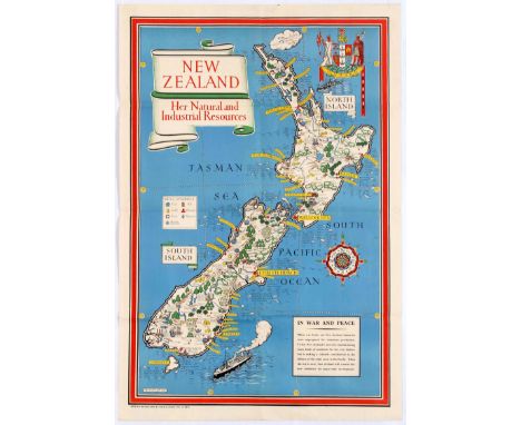
Original vintage World War Two pictorial illustrated map for New Zealand Her Natural and Industrial Resources featuring a great illustration by the notable graphic designer, cartographer and artist MacDonald Gill (Leslie MacDonald Gill aka Max Gill; 1884-1947) of a map of New Zealand depicting the country's various industrial and natural resources, including farms, mines and forests, gold, hydroelectric works, coal, timber, iron, tobacco, grain, cheese, butter, fruit, fish and sheep with the stylised title text on a scroll design, a plane and Onward coat of arms above, a compass on the side and a ship and information box below - When war broke out New Zealand industries were unprepared for munitions production. To-day New Zealand is not only manufacturing many kinds of munitions for her own defence but is making a valuable contribution to the defence of other areas in the Pacific. When the war is over, New Zealand will convert her new industries for peace time development. Very good condition, folds, minor tear on fold. Country:UK, Year:1943, Designer: Macdonald Gill, Size:79x53

Lot 1613

Original vintage pictorial map of North Africa: French Union, featuring color coded list of agencies and a coat of Arms on upper right corner - Credit Lyonnais Fonde en 1863, Afrique du Nord, Union Francaise. Shows major buildings and landmarks, parks, roads, cities and towns. Good condition, fold marks and creases. Country: France, Year: 1960, Designer: Lucien Boucher, Size (cm): 104x76

Lot 2100

Original vintage travel advertising poster for Union Line Steam Ship company of New Zealand, advertising routes fom Vancouver, Honolulu and Fiji and the all red route via San Francisco, Tahiti and Raratonga. Illustrations of a route map and a man on a boat appear. Union Line was once the biggest shipping line in the southern hemisphere and New Zealand's largest private-sector employer. It was incorporated by James Mills in Dunedin in 1875 with the backing of a Scottish shipbuilder, Peter Denny. Bought by shipping giant P & O around the time of the First World War it was sold in 1972 to an Australasian consortium and closed at the end of the twentieth century. Good condition, pin holes, small tears, staining in margin. Country: New Zealand, Year: 1910s, Size (cm): 102x63

Lot 2302

Original vintage poster showing an illustrated map of Afrique Occidentale Francaise (French West Africa.) Illustrations show people, animals, land marks and attractions that can be found in each area. Good Condition, light fold marks, tears in margin, small paper losses in margin, minor creasing, some ink marks from printing error. Country:France Year:1930s Designer:Leon Craste Size (cm):120x80cm

Lot 31

Antique framed and glazed hand coloured Map of Wiltshire by Robert Morden

Lot 566

Antique Hand Coloured Map of Dorset

Lot 580

Antique Robert Morden Hand Coloured Map of Somerset, framed and glazed

Lot 584

Menzies Map ' Persia ' hand Coloured Engraving 45 x 50cm approx. Framed and Glazed

Lot 79

John Speed framed and glazed Antique hand coloured map of "Wiltshire"

Lot 410

MAP: STANFORD'S NEW HAND-MAP OF THE UNITED STATES WITH THE RESULTS OF THE 1860 CENSUS, LONDON TOGETHER WITH JOHN ARROWSMITH'S FOLDING MAP OF SOUTH AMERICA 1839? IN ORIGINAL SLIP CASE. (2)

Lot 411

MAP: JOHN ARROWSMITH'S FOLDING MAP OF THE NORTH POLE c.1859 IN SLIPCASE AND ANOTHER OF ARCTIC DISCOVERIES c.1850 TOGETHER WITH A MAP OF THE COUNTRIES AROUND THE NORTH POLE BY EDWARD STANFORD. (3)

Lot 411A

MAP: A LARGE RUSSIAN HAND COLOURED 18th.C.FOLDING MAP ENTITLED IMPERIAL RUSSIA AND DATED 1787, LINEN BACKED. 183 x 83cms.

Lot 412

MAP: EDWARD STANFORD. A 19th.C.HAND COLOURED FOLDING MAP OF NEW ZEALAND, PUBLISHED IN 1863.

Lot 412A

MAP: G.F.CRUCHLEY. A 19th.C.FOLDING MAP OF INDIA.

Lot 413

MAP: A COLLECTION OF VINTAGE MAPS OF AFRICA TO INCLUDE A FOLDING MAP BY JAMES WYLD OF SOUTH AFRICA c.1840, AN EDWARD STANFORD MAP OF CENTRAL AFRICA AND ANOTHER OF SOUTH AFRICA TOGETHER WITH OTHER EXAMPLES OF VARIOUS AFRICAN REGIONS.

Lot 413A

MAP: A COLLECTION OF VINTAGE MAPS OF ENGLAND, IRELAND AND SCOTLAND TO INCLUDE A FOLDING MAP, JOHNSTON'S ENVIRONS OF EDINBURGH, EDWARDS STANFORD'S ENGLAND AND WALES c.1877, SEVERAL W.H.SMITH& SON'S REDUCED ORDNANCE MAPS, A HODGES & SMITH MAP OF COUNTY MAYO, VARIOUS ATLASES,ETC.

Lot 414

MAP: JOHN CAREY, 1799, A NEW MAP OF THE RUSSIAN EMPIRE, HAND COLOURED AND FRAMED AND GLAZED. 49 x 104cms.

Lot 414A

MAP: A COLLECTION OF ANTIQUE FOLDING MAPS OF VARIOUS EUROPEAN REGIONS, SOME WITH SLIP CASES TO INCLUDE G.F.CRUCHLEY EUROPE (FOUR PARTS), A FRENCH MAP OF POMPEI, AN UNUSUAL EMBOSSED PLAN OF VERSAILLES, A SWISS MAP 1820 TOGETHER WITH A BOUND GROUP OF ROMAN VIEWS, ROMA, 1819.

Lot 415

MAP: EDWARD STANFORD. MILITARY FOLDING MAP OF ZULULAND c.1879.

Lot 415A

MAP: BOWLES & CARTER. A FRAMED HAND COLOURED FOLDING MAP OF THE ROADS OF ENGLAND AND WALES, 60 x 42cms TOGETHER WITH AN EMANUEL BOWEN HAND COLOURED MOUNTED FOLDING MAP OF ESSEX.

Lot 416

MAP: ROBERT SAYER, 1791, A NEW AND ACCURATE MAP OF THE NORTH OR GREAT GERMAN SEA.....ETC,HAND COLOURED AND FRAMED AND GLAZED. 75 x 88cms.

Lot 416A

MAP: TWO EARLY ITALIAN HAND COLOURED MAPS, SOUTH AMERICA -TIERRA NOVA (Giacomo Gastaldi?) AND A SPANISH ISLAND- HISPANIOLA (ISOLA SPAGNOLA NOVA ) (Giacomo Gastaldi), 121 x 27cms TOGETHER WITH AN EARLY HAND COLOURED MAP BY RICHARD BLOME OF VARIOUS BRITISH ISLANDS. (3)

Lot 417

MAP: WILLIAM HOLE. TWO EARLY HAND COLOURED MAPS TO ILLUSTRATE A POEM POLYOLBION BY MICHAEL DRAYTON. 24 x 29cms. (2)

Lot 417A

MAP: JOHN OGILBY. A HAND COLOURED TRIP MAP OF OXFORD TO COVENTRY MOUNTED BUT UNFRAMED.

Lot 418

MAP: JOHN SPEEDE. TWO EARLY HAND COLOURED MAPS, DENBIGHSHIRE AND GLOUCESTERSHIRE, FRAMED AND GLAZED VERSO. 42 x 54cms.

Lot 603

Mapograph - 13x Different Map Rolls to include Roller

Lot 341

Nine prints, an aboriginal abstract painting and a map

Lot 765

A vintage map of Norfolk and Suffolk, Bacon's Excelsior

Lot 771

Scotia Regnum map, framed and glazed

Lot 310

John Cary, A New Map of The Russian Empire, 1799, double sheets, London published by J. Cary Engraver & Map Seller, No 181 Strand, 62cm x 53cm, (2)

Lot 311

John Cary, A New Map of Bohemia and Moravia, 1801, London published by J. Cary Engraver & Map Seller, No 181 Strand, 62cm x 53cm

Lot 312

Coloured map of Essex, vignette to the corner "Map of the County of Essex, from an actual survey made in the year 1824. By C & I Greenwood, published by the proprietors Greenwood Bros, 13, Regent St. Pall Mall. London", the lower section with map key, reference to the hundreds and depiction of Audley End House, in a gilt and ebonised frame, the map 75.5cm x 63cm

Lot 313

Map of Kent by J. & C. Walker, map of the southern part of Scotland, a double map of Devon and Cornwall, a map of Northumberland by H. Moll, four maps of Essex by Richard Blome, Fullarton and two by Thomas Moule, (8)

Lot 314

John Cary, A New Map of Spain and Portugal, 1801 London published by J. Cary Engraver & Map Seller, No 181 Strand, 62cm x 53cm

Lot 316

Three maps of Middlesex by Cole & Roper (2) and Thomas Moule, three maps of Monmouthshire by Thomas Kitchin & Thomas Moule (2), two maps of Northamptonshire by Creighton & Lewis and Thomas Kitchin, map of Somersetshire by Thomas Bowen, map Leicestershire by Thomas Kitchin, (10)

Lot 317

John Cary, A New Map of Hindoostan, 1806, London published by J. Cary Engraver & Map Seller, No 181 Strand, 62cm x 53cm

Lot 319

Two maps of South Wales and map of North Wales, map of Europe according to the treaties of Vienna and Paris 1815, map of France, map of the Netherlands, Belgium and Luxemburg (sic), map of Holland & Belgium, map of Austria, (8)

Lot 320

Map of Jersey drawn by Creighton, engraved by Walker, map of Shropshire, map of Guernsey, map of Lancashire, map of Gloucestershire, two maps of Westmorland, map of Cumberland, (8)

Lot 321

John Cary, A New Map of Italy including the islands of Sicily, Sardinia and Corsica, 1799, London published by J. Cary Engraver & Map Seller, No 181 Strand, 62cm x 53cm

Lot 322

John Cary, A New Map of Poland and the Grand Duchy of Lithuania, 1799, London published by J. Cary Engraver & Map Seller, No 181 Strand, 62cm x 53cm

Lot 323

Jan Jansson, 17th Century map, Northumbria Cumberlandia Et Dunelmensis, hand coloured map, 47cm x 35cm

Lot 325

John Cary, A New Map of The Kingdom of Portugal, 1801, London published by J. Cary Engraver & Map Seller, No 181 Strand, 62cm x 53cm

Lot 326

John Cary, A New Map of Sweden, Denmark and Norway, 1801, London published by J. Cary Engraver & Map Seller, No 181 Strand, 62cm x 53cm

Lot 328

Laurie's map of the world on Mercators projection, the folding map of book form, the interior cover with inscription dated 1857

Lot 329

Six maps of Cheshire by Creighton, Kitchin, Moule, & Oddy map of Lincolnshire by Moule, plan of Boston Lincolnshire, (8)

Lot 330

John Cary, A New Map of Ireland, 1799, London published by J. Cary Engraver & Map Seller, No 181 Strand, 62cm x 53cm

Lot 332

Jan Jansson map of Durham, circa 1641, Episcopatus Dunelmensis Vulgo The Bishoprike Of Durham, hand coloured, 51cm x 43cm

Lot 333

Map of Sussex, with details of the road from London to Arundel to the top section, three maps of Wiltshire, one with depiction of Salisbury Cathedral and Stonehenge to the lower section, map of Warwickshire, Map of Staffordshire, two maps of Yorkshire North Riding, (8)

Loading...Loading...
  • 109198 item(s)
    /page

Recently Viewed Lots