We found 109198 price guide item(s) matching your search
There are 109198 lots that match your search criteria. Subscribe now to get instant access to the full price guide service.
Click here to subscribe- List
- Grid
-
109198 item(s)/page


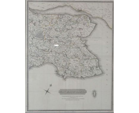


Lot 126
A Map of The Manor of Ketton in the County of RUTLAND…belonging to The Right Honourable Sir John Rushout Baronet……..taken from the survey upon the division in the year of our Lord 1768 by John Baxter, ink and colours on vellum, 112cm by 122cm Footnote: John Rushout, Ist Baron Northwick (July 23 1738 – Oct 20 1800) British Politician and a member of Parliament for Evesham. Please note this lot is subject to the Manorial Documents Rules 1959, 1963 and 1967, administered by the Historical Manuscripts Commission at the National Archives on behalf of the Master of the Rolls. Accordingly, the purchasers of the documents must notify the Secretary of the Commission of their acquisition and provide details of where they will be kept. They may in no circumstances be removed from England and Wales without the prior consent of the Master of the Rolls. Every change of ownership must be reported.

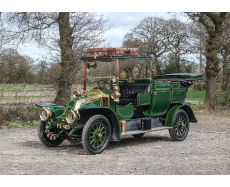
Lot 216
1908 Renault Model VI 20/30 Landaulette Transmission: manualMileage:Founded by Louis Renault and his brothers Marcel and Fernand in 1898, the company that would become France's biggest automobile manufacturer started humbly enough, with a solitary 1¾hp De Dion-engined prototype, the sprung rear axle of which would soon be copied by many contemporaries. Production at the Billancourt factory was soon under way on a large scale, demand for its products being enhanced by the performance of Renault cars in the great inter-city races so popular in France at the turn of the 19th Century.From the outset Renault engineering was of the highest quality and the arrival of multi-cylinder models really put the company on the map. By 1904 Renault was building its own engines: large-capacity fours at first, followed by the AX twin that later developed into the AG, famous for its WWI role as the 'Taxi de la Marne'. Messrs Renault and Frères exhibited five different models at Olympia in 1905, ranging from the twin-cylinder 8/12hp AX to the four-cylinder 35/45hp model. The 14/20hp was powered by a conventional, four-cylinder side valve engine of a little over three litres capacity, and featured the traditional Renault 'coal-scuttle' bonnet, rear-mounted radiator, semi-elliptic suspension, rear-wheel brakes, cone clutch and a three-speed gearbox. This model was still in the range in 1909 as the 'BX', although the days of its 'paired cylinders' engine were numbered, and by this time was being built with a four-speed gearbox.This 20/30 VB model is a very well-presented example indeed. Fitted with its original body, which was built by Stareys & Woolleys of Nottingham, the Renault looks superb and has a wonderful patina throughout. Included in the sale is a sizeable history file containing invoices going back to the 1960's. The leather at the rear is believed to be original as is the majority of the vehicle with stamps on the body dated early 1900's. In very good running condition the Renault comes from a private collection and is ready to be used immediately.
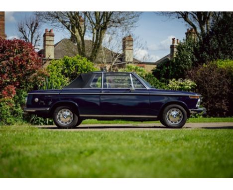
Lot 185
1973 BMW 2002 Baur Convertible Transmission: manualMileage:78805The BMW 2002 series is important in the history of BMW for several reasons; not least of which being that it brought the company out of near bankruptcy in the 1960s and put BMW on the map in the United States. It was the ancestral grandfather to the BMW 3 Series and was produced from 1968 to 1976. German BMW importer Max Hoffman is credited with the car's creation. He had suggested to BMW's engineering director that a 2.0 litre engine should be installed into the small two-door 1602 to improve performance and emissions. The resulting 2002 (named after the new motor's displacement) was popular in its first year on sale. This BMW 2002 is one of only 354 examples manufactured in right hand drive format. Conversions on these outstanding vehicles were carried out by coachbuilder Karosserie Baur in Stuttgart. Baur retained a 'T' bar in the roof design helping to dramatically reduce any scuttle shake.This stunning 2002 convertible by Baur is presented in deep Atlantic Blue with contrasting houndstooth trim and presented in excellent order. Restored in the mid-90s by specialists Jaymic with modifications including five-speed BMW 5 series gearbox, electric power steering, Weber twin-choke 34-36 carburettor conversion complete with correct electric fuel pump, a Schrick cam, engine re-build in 2016 with electronic ignition and stainless steel exhaust system, re-built centre console with new dials and a modern sound system including Apple Play and bluetooth phone system. The bodywork has been restored and repainted, a new Targa top fitted and upholstery renovated with new 'original' houndstooth check cloth and blue vinyl imported from Germany. Sitting on original steel wheels and hubcaps with a fabulous Mountney steering wheel, the car is accompanied by a history file including photo records of the restoration works, a large file of invoices going back to 1991 and MoT records back to 1984 which suggests that the mileage is correct. The vendor informs us that during the summer of 2021 the odometer stopped working, although the speedometer is working correctly and few miles have been covered since, but this would benefit from replacing or repairing. A rare and desirable 2002 for which viewing is highly recommended.


Lot 18
The Silver Map of Great Britain, Danbury Mint, 1978, etched with the boundary lines and coats of arms of the historic counties, embellished with 24 carat gold, a limited edition authorised and issued by the Council for the Protection of Rural England, 55 by 36cm, framed and glazed, 69 by 50cm, together with booklet of authenticity. (2)


Lot 506
Archer, Sir Geoffrey, The Birds of British Somaliland and the Gulf of Aden, published by Gurney and Jackson, four volumes, volumes one and two bearing library stamp for Kota Bharu, volumes three and four with presentation inscription signed by the author David Bannerman, together with a collection of bird booksVolumes I and II in poor condition, loose binding and covers missing. Volumes II and IV missing the map.


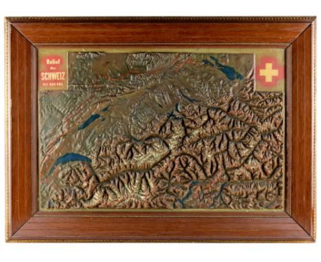
Lot 529
Globus - - Seltene Reliefkarte der Schweiz nach R. Leuzinger. Schweiz, um 1890, bezeichnet "Relief der Schweiz, M. 1:600.000", rückseitig mit handschriftlichem Papieretikett "Karte der Schweiz nach R. Leuzinger 1890", Relief in Gips modelliert und von Hand mit Ölfarben bemalt, montiert in Holzrahmen, die Reliefkarte mit Rissen. Größe mit Rahmen: Ca. 75 x 55 cm. Rudolf Leuzinger (1826-1896), Kartograph, gilt als einer der produktivsten schweizer Kartographen und besten Interpreten von Gebirgslandschaften und geologischen Formen.A Switzerland relief map after R. Leuzinger.Switzerland c. 1890, signed "Relief der Schweiz, M. 1:600.000", the plaster relief finely hand painted in oil, mounted in wooden frame, the reverse side with manuscript paper label "Karte der Schweiz nach R. Leuzinger 1890", the relief map with cracks. Size c. 75 x 55 cm.

Lot 518
Globus - - Drehbare Sternenkarte von R. Burkhardt. Genf/Schweiz, um 1900, herausgegeben von der Librairie R. Burkhardt, 2, Place du Molard à Genève, Pappe, geprägtes Leder, montiert auf schwarzem gedrechseltem Holzfuß, Rückseite mit gedruckter Gebrauchsanweisung, kleine Beschädigungen, die linke teilweise ergänzte Ecke mit Restaurierung. Höhe: Ca. 45 cm. Ein zweidimensionaler Himmelsglobus, die Universalkarte ersetzt zum Teil Himmelsglobus und Armillarsphäre. Rückseitig mit Buchhändleretikett Librairie H. Georg, 36, Passage de l'Hotel Dieu, Lyon. - Seltene französischsprachige Ausgabe der wohl in Aufmachung und Gestaltung auf A. Klippel basierenden Sternkarte, die im Verlag der Deutschen Lehrmittel-Anstalt Klodt, Frankfurt am Main erschien.A revolving celestial map by R. Burkhardt. Genève c. 1900, published by Librairie R. Burkhardt, 2, Place du Molard à Genève, embossed leather, cardboard and paper, mounted on ebonised turned wooden stand, reverse side with instructions for use, small damages, left side with restorations. Height c. 45 cm.
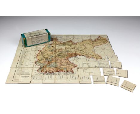
Lot 528
Globus - - Geographisches Puzzle Deutsches Reich. Dresden, um 1877, "Schulkarte vom deutschen Reiche, von Hugo Friedemann, Dresden, Verlag von Alwin Kuhle (Carl Adler's Buchhandlung) 1877", von Hand kolorierter Stahlstich, komplett in Pappschachtel mit Deckeltitel. Größe Karte: Ca. 32 x 40 cm, Größe Pappschachtel: Ca. 12 x 5 x 5 cm.A geographical puzzle. Dresden/Saxony c. 1877, "Schulkarte vom deutschen Reiche, von Hugo Friedemann, Dresden, Verlag von Alwin Kuhle (Carl Adler's Buchhandlung) 1877", hand-coloured print, complete in cardboard box. Size of the map c. 32 x 40 cm, dimensions box c. 12 x 5 x 5 cm.
Lot 140
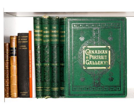
*** Please be aware the description of this lot has changed *** Gray (Hugh) Letters from Canada, first edition, folding engraved map with border hand-coloured (laid-down and mounted on stub), 3 folding tables, book-label to pastedown, some slight toning and occasional spotting, contemporary half calf, spine gilt, lightly rubbed, [Sabin 28393; Goldsmiths' 19842; Kress B.5510], 1809 § Dent (John Charles) The Canadian Portrait Gallery, 4 vol., plates, tissue-guards, scattered marginal spotting, original decorative cloth, gilt, slight bumping to corners and extremities, Toronto, 1880; and others, 8vo & 4to (9).
Lot 152
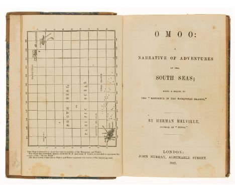
Melville (Herman) Omoo: a Narrative of Adventures on the South Seas, first English edition, second issue with "P" signature not fully printed on p.209, map frontispiece, illustrations, bound without half-title or advertisements, scattered spotting, previous owner's pencil signature, contemporary half-calf, a little rubbed, 8vo, 1874.
Lot 268
NO RESERVE Britain.- Depping (G.B.) L'Angleterre ou Description Historique et Topographique du Royaume Uni de la Grande Bretagne, 6 vol., folding engraved map of the British Isles and 55 maps only (of 58) all with hand-colouring in outline, folding index, fifteen engraved plates, original printed wrappers, uncut, some light creasing, some cracking to spines with vol. 4 upper cover working loose but a very good set generally, 8vo, Paris, Étienne Ledoux, 1824.⁂ Rare in the original wrappers.
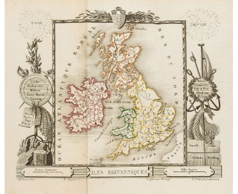
Lot 269
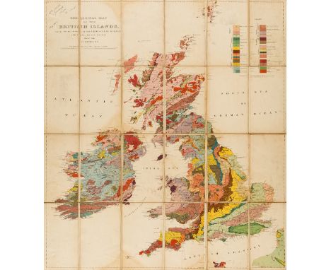
NO RESERVE British Isles.- Teall (J.J.H.) Geological Map of the British Islands, based on the work of the Geological Survey, 2nd edition, lithograph printed in colours, 815 x 320 mm (32 x 12 1/2 in), dissected and mounted on linen, collector's ink inscription in the upper left dated '1913', surface dirt, browning and handling creases, unframed, folding without slipcase, 8vo, 1912.

Lot 270
England & Wales.- Saxton (Christopher) and Abraham Ortelius. Anglia regnum si quod aliud in toto Oceano ditissimum et florentissimum, fine map with large decorative cartouche and strapwork mileage scale, additional strapwork cartouche paying tribute to Christopher Saxton and a maritime vignette commemorating the attack of the Spanish Armada, engraving with full hand-colouring, on laid paper with crossed arrows watermark, platemark 390 x 485 mm (15 1/4 x 19 1/8 in), German text verso, central vertical fold as issued with faint parallel crease, minor surface dirt, framed and glazed, [Antwerp, Vrients, 1603].

Lot 271
NO RESERVE England & Wales.- Seller (John) and Francis Grose. Collection of 56 county maps, including Guernsey, Jersey, Isle of White, and Isle of Man, each leaf approx. 340 x 230 mm (13 1/4 x 23 in), scattered spotting and surface dirt, bound in later blue cloth worn, 4to, [circa 1780]; together with Fullarton & Co.'s 'The Imperial Map of England and Wales' folding in sections into original cloth box, splitting, and with a largely disbound copy of Philip's 'The Imperial Atlas of the World', lacking covers, folio, 1914; sold not subject to return.

Lot 272
NO RESERVE Ireland.- Ortelius (Abraham) Eryn. Hibernaie, Britannicae Insuale, the first map of Ireland to include any geographic details, based on Mercator's 1564 wall map of the British Isles and is presented with west oriented to the top, large strapwork cartouche in the upper right corner, engraving with hand-colouring on laid paper with indistinct armorial watermark, platemark 350 x 475 mm (13 3/4 x 18 3/4 in), sheet 418 x 545 mm (16 1/4 x 21 1/2 in), minor splitting to foot of central fold, large old repaired tear just left of fold, other marginal tears, some repaired verso, uneven toning and surface dirt, unframed, [circa 1590].Literature:VdB 22

Lot 275
Kent.- Speed (John) Kent with Her Cities and Earles Described Observed, county map with inset maps of Rochester and Canterbury, engraving with early hand-colouring, platemark 380 x 510 mm (15 x 20 in), sheet 405 x 520 mm (16 x 20 1/2 in), English text verso with first edition woodcut initial verso but with variant intertwined border, central vertical fold with minor parallel creasing, marginal nicks and surface dirt, spotting and handling creases, unframed, [Sudbury and Humble, 1611-1623]; together with William Kip's 'Cantium quod. nunc Kent', Bowen's 'An Accurate map of the County of Kent...', and a Saxton/Kip map of Somerset, various sizes, all unframed, 17th and 18th century (4)

Lot 277
London.- Speed (John) Midle-Sex described with the most famous Cities of London and Westminster, with inset plans and views of St Paul's and Westminster Abbey, engraved map with hand-colouring, on laid paper with armorial watermark, platemark 380 x 510 mm (15 x 20 in), good margins, surface dirt and browning, handling creases, unframed, Bassett & Chiswell, [1676]; together with a hand-coloured impression of Johannes Kip's 'The House att Chelsey in the County of Middlesex one of the Seats of the Most Noble & Potent Prince Henry Duke of Beaufort...' after Knyff, unframed, [1708] (2)

Lot 280
NO RESERVE West Yorkshire.- Whitley & Booth (Halifax-based publishers) Map of Forty Miles Round Halifax, engraved map with original hand-colouring, 1310 x 1000 mm (51 3/4 x 39 1/4 in), dissected and mounted on linen, minor surface dirt, folding into contemprary boards, rebacked, very worn, 4to, [circa 1830]; together with an incomplete copy of 'Cary's New and Correct English Atlas' comprising 47 maps only, and a Midland Railway Contract Plan from the Huddersfield Line, and a copy of 'The Authentic Map Directory of South West Yorkshire', large 4to, v.d. (4)

Lot 281
Yorkshire.- Teesdale (Henry) To the Nobility, Gentry & Clergy of Yorkshire, this map of the county constructed from a survey commenced in the year 1817 & corrected in the years 1827 & 1828 is respectfully dedicated by the proprietors, large scale county map in 3 sections, engravings with original hand-colouring, each section approx. 1830 x 750 mm (72 x 29 1/2 in), each section dissected and mounted on linen and edged with green linen, some missing, scattered spotting and browning some off-setting, minor surface dirt, folding with marbled ends into green morocco slipcase, gilt, very worn, 4to, 1828.


-
109198 item(s)/page