We found 108737 price guide item(s) matching your search
There are 108737 lots that match your search criteria. Subscribe now to get instant access to the full price guide service.
Click here to subscribe- List
- Grid
-
108737 item(s)/page


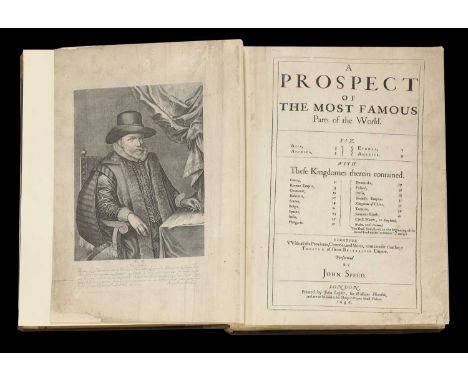
Lot 139
Speed (John) A Prospect of the Most Famous Parts of the World, Viz. Asia, Africa, Europe, America. L, printed by J Legatt, for William Humble, 1646. Folio, Frontis portrait plus 20 double-page Maps (9 with colour outline), The map of America shows California as an Island; Bound with: The Theatre of the Empire of Great Britaine, in four parts. L, 1650, full page coat of arts. PP: vii, (i)b, 146, 10 (Table). With a double-page list of the Royal Navy of Great Britain, plus 48 Maps; Wales, L, title page: 1646, plus 14 Maps; Scotland, 1646, one Map; & Ireland, 1646, plus 5 Maps. Total of 68 Maps (one more than called for!), 9 maps with colour outline. Full leather. Please Note: This copy spent months at the British Museum, being restored to a very high standard. A lot of the restoration is to the first few pages, including the right margin of the Map of America (please see the image).From the Paul Bentley collection of maps and atlases.

Lot 140
ATLASES: Speed (John) A Prospect of the Most Famous Parts of the World, Viz. Asia, Africa, Europe, America. L, M.S. For Roger Rea, 1665. PP; 206, Plus 20 Maps. Bound with: England, Wales, Scotland & the land as described.. 1666, with 63 Maps (2 with a fold). Not paginated, Later full leather, a couple of small tears and repair to text; small stain to the margin of one map. (1 x 11.5cm)From the Paul Bentley collection of maps and atlases.
Lot 141
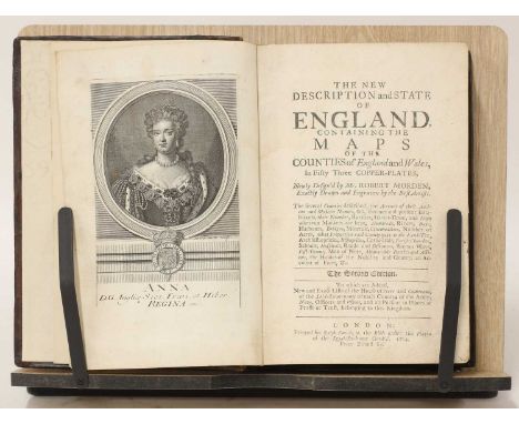
ATLAS: MORDEN, Robert: The new description and state of England, containing maps of the counties of England and Wales in 53 copper plates. R Smith, 1704, 2nd. Edn.287pp. Complete with a Frontis, Map of England, plus 53 double-page county maps. Cont. full calf, recased with new endpapers. Light damp stain to top margin of a number of pages- not affecting the maps; worm damage to the bottom margin of the last 20 leaves, affecting the bottom two lines in a few places.From the Paul Bentley collection of maps and atlases.

Lot 143
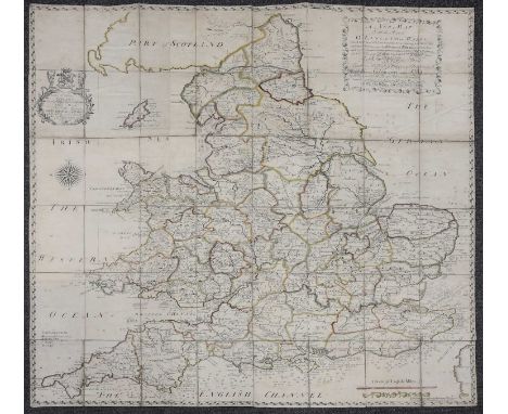
ARMSTRONG, M J: An Actual Survey of the Great Post-Roads Between London and Edinburgh. W Faden, 1783, 2nd. Edn. PP: Frontis Map, TP (with vignette), 8 + 44 Maps, each with an explanation page facing. Later half leather, marbled boards & new endpapers. VGFrom the Paul Bentley collection of maps and atlases.

Lot 144
ATLASES: STARLING, T: Geographical Annual or Family Cabinet Atlas. Bull, 1833, with 51 hand coloured maps. Full leather, rubbed. One map with a small stain; [Depping & Perret]: ATLAS, consisting of 58 hand coloured Maps from "L'Angleterre-ou description historique et topographique..". No title page, ma0s dated 1823. Maps measure 12 x 8 cm. Full leather binding; STOW, John: A school Atlas of physical Geography. Blackwood, 1861, new edn. with colour maps. Cont. half leather; rubbed & torn. (3)From the Paul Bentley collection of maps and atlases.

Lot 147
ATLAS: GREENWOOD (Charles & John): Atlas of the Counties of England, from Actual Surveys Made from the Years 1817 to 1833. C & J Greenwood, April 1st, 1834. Elephant folio (64 x 42.5 cm). Engraved double-page title with hand-coloured general map plus 46 double-page hand-coloured maps, each with a view, engraved by J. & C. Walker.Cont. Half leather, rubbed; VGFrom the Paul Bentley collection of maps and atlases.
Lot 148
CARY'S NEW AND CORRECT ENGLISH ATLAS: Being a New Set of County Maps from Actual Surveys. Printed for John Cary, 1787, first edition. Complete with engraved title, engraved dedication and 46 engraved maps on 47 sheets dated 1787, and with partial hand colouring. Descriptive text opposite each map and a six page Subscribers' List. Large 4to. Later half leather over marbled boards and new endpapers. Very good.

Lot 152
MAPS / GERMAN PLAYING CARDS: Johann Hoffmann (Publisher): Europaeisch-Geographische Spiel-Charte, 2 volumes. V.1- With 49 of 52 Map cards, lacking: 4 & 5 of Diamond & Jack of Heart. No title page to vol.1, just the map cards. All on thick cards (one a little shorter), And scattered worm damage throughout in various degrees. Ten with small holes in each, the rest much worse; Vol. 2- Engraved Frontis/ extra title & title page, Nuremberg, Johann Hoffmann, 1678. PP: 231 Plus 5 Maps: Sicilia, Malta, Sardinia, Croatia/Bossena, & Candia. Bound in matching full red morocco with gilt decoration by Townsend of Sheffield, (12.75 x 7.5 cm). (2)From the Paul Bentley collection of maps and atlases.
Lot 157
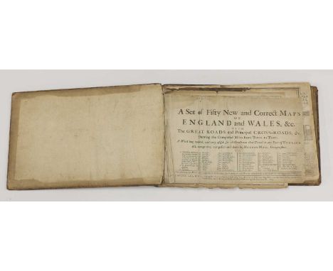
TWO ATLASES, bound in one volume: 1- A SET OF FIFTY NEW AND CORRECT MAPS OF ENGLAND AND WALES, Etc. The Great Roads and Principal Cross-Roads, Etc. Shewing the Computed Miles from Town to Town. Sold by H. Moll, et al, 1724. Lacking five maps of the fifty (1,2,8,13,14); title page detached and with tears, also two maps with tears; stain to upper margin (not affecting the image); BOUND WITH: Moll (Herman): Atlas Minor; Containing a new and curious set of Sixty-five maps in which are shewn all the Empires, Kingdoms, Countries, States in all the known parts of the Earth. Bowles, no date, 2nd. edition. c1730. With 61 of 62 maps, lacking the first map. Stain to the upper margin of the last 27 maps, just touching the image on some; and a worm hole to the blank margin of the last four maps. The two works are bound in one full leather volume; covers detached. Sold as a collection of maps, not subject to return. Moll's Atlas Minor was first issued in London in 1729 with later additions appearing as ''Bowles's Atlas Minor''.


Lot 180
AMERICANA: 1- CATLIN, George: Letters and Notes of the Manners, Customs and Condition of the North American Indians. 2 Volumes. L, Tilt & Bogue, 1842, 3rd. Edn. The number of illustrations is in dispute. The following illustrations are present: V.1- Frontis + folding map +3-114 + 3 plates (not numbered) + 1 plate (numbered 101 1/2); V.2- 2 Maps + 115-312 + 1 plate (numbered 210 1/2), BUT missing numbers: 137, 142, 149, 159, 246, & 247. The total present including three maps is 312. Original cloth, rubbed and torn; upper cover & frontis in V.1. Detached; hinges cracked in V2. It looks complete, but is sold A/F; 2- Another copy, 2 vols. In 1. Philadelphia, Bradley, 1860. Frontis and 16 plates- ONLY? (There is no list of plates), plus numerous text illustrations. 792pp. Original full embossed leather gilt; rubbed; occasional small stain and tear (well away from the text). A/F; 3- Map Showing Location of Sheridan, Wyoming and Surrounding Reservations, 1895. (41 x 32 cms). Tear to the fold; 4- Map of the United States West of the Mississippi River, 1926. (66 x 45 cms); 5- Frank Bond: Map of the Territory of Hawaii, 1905 coloured and folding (83 x 56 cms); Plus Four other US interest. (11)

Lot 183
AMERICANA: PHELPS, Humphrey: Traveller's Guide through the United States; Containing Upwards of Seven Hundred Rail-road, Canal, and Stage and Steam-boat Routes. Ensigns & Thayer, New York, 1849. PP: tp, 70 + a large hand coloured folding map loosely inserted, 251/2 x 20 inches (65 x 51 cm). Original pictorial cover gilt.From the Paul Bentley collection of maps and atlases.

Lot 199
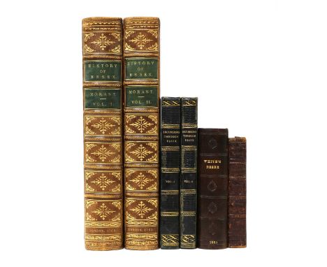
ESSEX: Morant, Philip: 1- The History And Antiquities of the County of Essex, 2 vols. T. Osborne; etc. 1768. In two volumes. Folio, PP: vi (including list of subscribers), xxviii, (iv), 195, 28, 519, (I)list of plates; Vol.2- Title page, contents, preface, another title page dated 1766, dedication page, 646. With 32 Maps and plates (some folding). Cont. full leather with later spines; upper cover of vol.1 almost detached; browning to one of the folding plates and a little frayed; the odd small tear; 2- The History and Antiquities of Colchester, in the County of Essex. In Three Books. W. Bower. 1748, 1st. Edn, PP: Title, 100, 54, 53, (v) Index, (iv) Addenda, Plus: Frontis, folding Map, And 9 Plates (one folding). Cont. full calf. Ex-Duke of Hamilton collection, with his bookplate to front pastedown. (3)

Lot 200
ESSEX: Muilman Peter (A Gentleman): A New and Complete History of Essex… in six volumes. Lionel Hassall, Chelmsford, 1770-72. With 54 of 57 plates (lacking 3 plates). Cont. full leather, rubbed; Upper cover of vo.1 detached; plus: Wright, T & Bartlett, W: History and Topography of The County of Essex comprising its Ancient and Modern History; in 2 vols. G Vertue, 1831-35, With folding colour map and 100 Plates; 4to. PP696, 834. Cont. half leather, rubbed and hinges cracked; No printed title pages, only the engraved ones with vignettes. (8)
Lot 202
The Curiosities, Natural and Artificial, of the Island of Great Britain, 6 vols, R Swagg, no date, c1780. With numerous plates. Cont. speckled calf with later spines. Ex-Libra, with the usual stamps; The Scottish Highlands: Highland Clans and Highland Regiments complete in two volumes. A Fullarton, 1877. With two maps and numerous plates, including coloured tartans. Cont. half leather; rubbed. Good+; Souvenir of Edinburgh with Twenty-Five Chromo Views. Nelson, 1892; Bacon's commercial map of Great Britain. No date, c1890. A/F. (10)

Lot 207
SOUTH AFRICA- CAMPBELL, John: Travels in South Africa, Undertaken at the Bequest of The London Missionary Society. Printed for The Society in 2 volumes. Published and Sold by Francis Westley, 1822. With a folding map plus 12 plates, all hand coloured. Cont. full leather, rubbed and hinges cracked; some offsetting; Plus: South African Butterflies. Vol. 2 only. 1887. (3)

Lot 23
Two MAPS: 1- Emanuel Bowen: An Accurate map of the County of Essex, Divided into its Hundreds. Dedicated to Benjamin Mildmay Earl Fitzwalter. C1767; 2- CHAPMAN, John & Peter ANDRE: A map of the county of Essex. (The index map for their very large map). Both Hand coloured, mounted, framed & glazed, 55 x 71cm and 46 x 60cm respectively. (2)

Lot 26
MAPS: SAXTON: A Map of Suffolk, corrected and amended with many additions… C1720, with a fold in the middle. Please find enclosed a copy of a letter from the British Museum expert about it and one other map of Suffolk and their rarity, (54 x 44 cm).From the Paul Bentley collection of maps and atlases.

Lot 27
MAP: SMITH: A new Mapp of the county of Suffolk with the post and cross roads and other remark according to the latest and best observations, Smith/Dicey & co. no date, c1707-51, Please find enclosed a copy of a letter from the British Museum expert about it and one other map of Suffolk and their rarity (54 x 44 cm)From the Paul Bentley collection of maps and atlases.


Lot 30
SUSSEX Map: FADEN, W: A topographical map of the county of SUSSEX, divided into Rapes, Deaneries & Hundreds, planned from an actual survey by a scale of one inch to a mile. Begun by W. Gardner and the late T. Yeakell, Completed by Thos. Gream, William Faden, 4 June 1795. Hand coloured, linen backed and folding, with a cont. slipcase, rubbed (195 x 92 cm)From the Paul Bentley collection of maps and atlases.

Lot 31
FADEN, William (publisher): A Plan of His Majesty's Forest, called The New Forest, in the County of Southampton laid down from Surveys taken by Thos. Richardson, Wm. King, and Abm. And Wm. Driver, [London], William Faden, 1789. Large hand coloured, linen backed and folding, together with the Index map, also dated 1789. Housed in a cont. full leather box; rubbed.


Lot 33
MAPS: COLBY, Col: Map of Cambridgeshire. Engraved by B. Baker, 1834. Linen backed, folding with marbled ends and slipcase. (150 x 140cm); COLBY, Col: Map of Northamptonshire, Bedfordshire, Hertfordshire & Buckinghamshire, 1823, this Electrotyped 1872. Hand coloured, linen backed and folding with cloth ends, (179 x 127cm); LEA, P (corrected): MAP of the county of Northamptonshire, together with ye three small counties of Bedford, Huntington & Rutland. With 5 inset plans & 2 shields, C1693. (56 x 46cm); Northamptoniae Comitatus Descriptio..… no date, c1675. Cropped, with no borders (47.5 x 36.5cm). (4)From the Paul Bentley collection of maps and atlases.


Lot 344
CARY’S New Guide for ascertaining Hackney Coach Fares. 1801. With a large folding hand-coloured Map. Later half leather, VG; Cary's new itinerary: the Great roads, both direct & cross throughout England & Wales.. 1815, 6th. Edn. With 7 folding maps (including the frontis). Later full leather; Restored copy; Pattisons Cyclists Road Maps: Nine Maps in a specially made clamshell box. Each map with pictorial verso and folds into the original covers, c1890; Lett's Cycling maps of England and Wales, 1884. Large folding map with a specially made clamshell box. Tears to the folds; Howard, C: The roads of England & Wales; an itinerary for Cyclists, tourists & travellers. Letts, Son & Co. 1884, 4th. Edn. 423pp Plus numerous illustrated adverts. Original boards gilt. Lacking the map? (5)
Lot 351
ESSEX: Morant, P: The History & Antiquities of the County of Essex, Two Volumes. T. Osborne; etc. 1768 & 1763. With numerous maps and plates, many folding. Folio, cont. full calf; Excursions in the county of Essex. In Two volumes. Longman, et al, 1818-19, 1st. Edns. Near cont. half leather. VG; White, W: History, gazetteer, & directory of the county of ESSEX. 1863, 2nd edn. As usual, Lacking the map. Cont. full leather, rebacked; County biography: or the lives of… in Essex, Suffolk & Norfolk. Witham & Maldon, for P Youngman, 1825, 1st. Edn. With 68 portraits. Cont. half leather, rubbed. (6)
Lot 354
RIVERS: Crowquill, Alfred: A Guide to the Watering Places. Harwood, no date (1839). PP: 50, (x) adverts, with a frontis plus 16 plates. Later cloth backed marbled boards; Progress and Commerce, 1894: Rivers of the North. 4to. 264pp, illustrated throughout. Original cloth gilt. Inner hinges cracked; JEFFREYS, John: A new map of all the rivers of England & Wales, traced from the springs into the sea, Sept 14, 176? Hand coloured, linen backed and folding (125 x 120 cm). Rare. (3)From the Paul Bentley collection of maps and atlases.


Lot 41
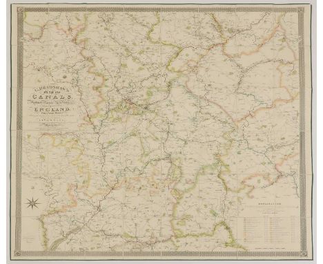
BRADSHAW, G: Map of Canals, Navigable Rivers, Railroads etc. of the Midland Counties of England from Actual Survey,.. Manchester, A Prentice, 1829, engraved and printed by W R Gardner. (132 x 129 cm). Hand coloured, linen backed and folding with silk piping trim, and a 20pp Appendix booklet in full leather, both housed in the original full calf box, VGFrom the Paul Bentley collection of maps and atlases.

Lot 45
LOADER’S Scientific & Commercial Map of England and Wales in which are delineated the canals, rail-roads & navigable rivers, the extent of the navigation of each river with the elevations of the canals, together with the geology and principal situations of mineral productions. W. Day, 1831, 1st. edn. (138 x 112 cm)From the Paul Bentley collection of maps and atlases.
Lot 46
MAPS: BARTHOLOMEW, J: The Imperial Map of England & Wales, according to the ordnance survey with the latest additions, shewing clearly every feature of roads, canals, rivers, gentlemen's seats, & c. Scale 4 miles to an inch, published by A Fullarton & Co, No date. 18 sections, 1-15 measuring 74 x 54 cm, and 16 a,b,&c 74 x 27 cm. Hand coloured, linen backed and folding; plus a folded index sheet (tears to folds). Housed in the original slipcase, rubbed and with tears. The map is clean; Blofeld & Co: Map of Great Britain, with "Continuation of Scotland". Hand coloured, linen backed & folding, with cloth ends and matching slipcase, (120 x 92 cm); MALBY'S Map of the stars visible in Great Britain and Ireland, reduced to the year 1850, compiled from the globes under superintendence of Diffusion of Useful knowledge. Hand coloured, linen backed and folding into the original fold-around boards, spine of covers torn (49 x 48 cm); SDUK MAP: Geological Map of England and Wales. Chapman & Hall, 1843 (40 x 34 cm). (4)From the Paul Bentley collection of maps and atlases.

Lot 48
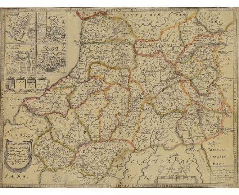
MAPS: COLTMAN, Nath: New Map of South Wales. Laurie and Whittle, 1st. Jan 1798, 4th. Edn. With considerable additions… to 1807. Linen backed, folding & with slipcase (72 x 55 cm); MAP OF Randor Brecknock, Cardigan & Carmarthen shires. Hand coloured, with repair and strengthened from the back (48 x 37 cm); WALES: Cambriae Typus Auctore Humfredo Lhuydo, with Latin text to verso, Over Cleaned! Hence hard to tell the age! With a middle fold (54 x 44 cm); & Oliver & Boyd's Travelling Map of Scotland, with the distances on the great road.. Edinburgh, no date (1821). PP: (iv), 56 (made up of double and single page hand coloured maps), (I) blank, 10 (principal roads), (I) Table, (I) blank. Cont. leather backed boards. Rare. (4)From the Paul Bentley collection of maps and atlases.


Lot 54
The THAMES: 1- Taunt, H W: A new map of the River Thames from Oxford to London. No date, 5th. Edn. With a photographic frontis, 2 plates, a folding table, plus 33 double page maps with 101 Albumen photos. 215pp. Original brown pictorial cloth gilt; covers torn and almost detached; 2- FEARNSIDE, W G: Eighty picturesque views on the Thames and Medway, engraved on steel. Black & Armstrong, no date, C1834 (Price Two Guineas). (2)From the Paul Bentley collection of maps and atlases.

Lot 55
Taunt, H W: A new map of the River Thames from Oxford to London. No date, 3rd. Edn. (1879). With a frontis, general map of the Thames, plus 33 double page maps with 100 Albumen photos. 215pp. Original pictorial cloth gilt; rubbed and hinges cracked.From the Paul Bentley collection of maps and atlases.

Lot 56
Taunt, H W: A new map of the River Thames from Oxford to London. Oxford, (1872) preface dated, 1st. edn. With 24 colour maps and 79 small albumen photographs of the Thames (Although the title calls for 80, it is issued with space for only 79), hence complete. 66pp (including index & adverts). Oblong 8vo. Original green cloth gilt. Recased with new endpapers.From the Paul Bentley collection of maps and atlases.
Lot 57
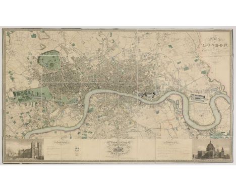
LONDON MAP: GREENWOOD, John & Christopher: Map of London from Actual Survey Made in the Years 1824, 1825 & 1826. Published August 21. 1827, first edition. Contemporary hand colouring, linen-backed with silk pipe trim and folding. 185 x 147cm, with inset views of Westminster Abbey and St Paul's Cathedral. Housed in the original full tree calf box, VGFrom the Paul Bentley collection of maps and atlases.
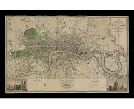
Lot 58
LONDON MAP: GREENWOOD, John & Christopher: Map of London from Actual Survey Made in the Years 1824, 1825 & 1826. Published August 21. 1827, first edition. Contemporary hand colouring, linen backed with silk pipe trim and folding. 185 x 147 cm, with inset views of Westminster Abbey and St. Paul's Cathedral. Housed in the original full leather box, VGFrom the Paul Bentley collection of maps and atlases.

Lot 59
Cary's Survey of the High Roads from London to Hampton Court... With the number of inns & turnpikes. J Cary, July 1st, 1790. 1st. Edn. With a double-page hand-coloured general map, hand-coloured general Plan, Plus 80 hand-coloured numbered routes, on 40 pages. Later half leather over marbled boards; John Towneley's Armorial bookplate to front pastedown, VGFrom the Paul Bentley collection of maps and atlases.


Lot 61
LONDON MAP: Cary's New and Accurate Plan of London and Westminster, the Borough of Southwark and parts adjacent: viz. Kensington, Chelsea, Islington, Hackney, Walworth, Newington &c with an Alphabetical list of upwards of 500 of the most principal streets with references to their situation, Jan 1, 1806, Linen backed, folding & with some hand colouring. tears to folds (125 x 82 cm).From the Paul Bentley collection of maps and atlases.


Lot 67
WYLD, James: An Atlas of London and its Environs. No date, c1849, Elephant folio (43.5 x 31 cm). Title page (with an index map), plus 9 double-page Plans with contemporary hand-colouring, 5 & 6 are joined together to make a full plan of London, measuring: 80 x 42 cm. Original cloth with leather label to upper cover. Later spine and new endpapers; covers a little smudged, internally very clean. A rare survivor!From the Paul Bentley collection of maps and atlases.

Lot 72
LONDON: MAITLAND, William: The History of London from its Foundation to the Present Time, two volumes of text plus an Atlas volume. T Osborne & J Shipton, 1756. Folio, PP: V1- Frontis, viii, 712; V2- Title page, 713-1410, followed by: Contents, Appendix & Subscribers' list; V3- 122 Plates, map & plans (many folding), (ii) direction to binder). Later half leather with cont. marbled boards (3)From the Paul Bentley collection of maps and atlases.


Lot 77
LONDON MAP: MOGG, Edward: An Entire New Plan of the Cities of London & Westminster with the Borough of Southwark, Comprehending the New Buildings and other Alterations, to the time, 1814. Hand coloured, linen backed, folding & with the original slipcase, rubbed. (90 x 48 cm).From the Paul Bentley collection of maps and atlases.


Lot 85
LONDON Map: Faden (William): A New Topographical Map of the Country in the Vicinity of London, Describing all the New Improvements, Metropolitan Boroughs And Parish Boundaries.. Published By James Wyld, Successor To Mr. Faden, 1840. Hand coloured, linen backed and folding with endpaper adverts and the original slipcase, with label to upper cover, VG (82 x 82 cm).From the Paul Bentley collection of maps and atlases.
-
108737 item(s)/page