We found 109198 price guide item(s) matching your search

Refine your search

Year

Filter by Price Range
  • List
  • Grid
  • 109198 item(s)
    /page

Lot 175

After John Norden- A framed and glazed 17th century hand coloured engraved map of Sussex by William Kip 'SUSSEXIA'. Label verso. H.43 W.59cm.

Lot 3233

Pictures, to include: two nineteenth-century prints in colours, 'The New Steam Carriage' and 'The Enterprise Steam Omnibus', framed and glazed, image size 29 x 44cm and 32 x 42cm; original 1990s pen newspaper cartoon, framed and glazed, image size 29 x 60cm; Sundat Express 1969 cartoon print, framed and glazed, image size 25 x 35cm; reproduction 'Teviot' map, framed and glazed, map size 40 x 51cm. (5)

Lot 409

Military General Service 1793-1814, 4 clasps, Busaco, Albuhera, Badajoz, St. Sebastian (J. Ferrier, Serjt. R. Arty. Drivers.) medal removed from a mount and with reconstituted suspension with copy clasps, much pitting and some weakness to name, therefore fair £200-£300 --- John Ferrier was born in the Parish of Liberton, Edinburgh, and enlisted at Musselburgh for unlimited service in the Royal Artillery, aged 17 years 133 days. He was promoted to Corporal and Bombardier in September 1805, to Sergeant in August 1820, and to Quarter Maser Sergeant in August 1823. He was discharged at Woolwich on 31 October 1826, in consequence of ‘having obtained the situation of Clerk in the Ordnance Map Office at the Tower.’ Sold with copied discharge papers.

Lot 641

An early map of the Isle of Mull, framed and glazed, 45 x 56cm and a framed plan of Glasgow (2) Condition Report:Available upon request

Lot 1145

A Robert Morden hand coloured 17th Century map of Shropshire showing part of Montgomeryshire, Denbighshire, Radnor, Herefordshire and Worcestershire . The being the 1695 published edition. Framed and glazed  

Lot 1146

An early 17th century John Speede map of the Countie of Radnor described and the Shyretownes Sittuatione (Sic), Anno 1610, an engraved and coloured map being double glazed front and verso.

Lot 1546

A vintage 20th century Zoffoli Italian17th century style globe in the manner of P Duval D'Abbeuille. The map having longtitude and latitude with nautical / maritime detailing raised on a circular wooden base. Measures 45cm high

Lot 620

A Maps International world map, framed.

Lot 215

HAND COLOURED MAP OF BRITISH ISLES 53CMS (H) X 62CMS (W) APPROX

Lot 315

John Cary, 18th century engraved and hand coloured map of Yorkshire, dated 1787.

Lot 330

A quantity of pictures. Including three framed watercolours on silk depicting oriental scene, Map of Derbyshire, etc.

Lot 65

After John Speede, A map of The West Ridinge of Yorkshyre, dated 1610 0n vellum. Tears around edges

Lot 1080

A 1790 John Cary Antique Road Map of London to Hertford. In frame - 24 x 29cm. A/F

Lot 200

A vintage map print ordnance survey of county Westmorland

Lot 116

British Rail Eastern Region carriage line map showing routes from Liverpool Street and Fenchurch Street. The blue line shows the route to Hertford East and Bishops Stortford, the red line to Clacton and the green line to Shoeburyness. Melamine on aluminium (melaminium) measuring 29.5in x 7.5in. Extremely good condition.

Lot 134

London Underground tube stock map of the Metropolitan Line showing all stops between Aldgate to Amersham, Uxbridge and Chesham. Totally original, unused peel-back map measuring 58in x 8.5in.

Lot 232

Posters quantity 2 double royal 24in x 40in comprising: British Railways (WR) Holiday Runabout Tickets Cornish Riviera Area. Shows a 15/- 3rd class fare to various Cornish and Devon destinations including the Withered Arm route; British Railways Map of the System. Both have folds and are in reasonable condition. (2 items)

Lot 310

Oil Painting on canvas depicting A3 Pacific 60056 Centenary alongside A1 No 60115 on Copley Hill Shed Leeds by Steve Wise. Unframed measuring 30in x 24in. Together with a cardboard advertising Racing Calendar for 1912, listing all racing fixtures for that year highlighting Lingfield Park Race Course. Shows an outline Railway Map of South/Mid UK and Horse Racing Centres. Measures approximately 20in x 15in and although damaged it is a considerable rarity. (2 items)

Lot 312

BR Intercity Map of the System issued 1989, Black on White Melamine measuring 23.5in x 16.5in together with 2 brass plates signifying coach repair and painting by Vic Berry Railway Vehicle Division Leicester. (3 items)

Lot 398

A pair of rolled Maps on wooden batons, both printed by George Philip & Son comprising: LNER Collieries of Yorkshire, Nottinghamshire, Derbyshire, Lancashire, Cheshire & North Wales and their Railway Connections - measuring 24in x 37.5in; B.R.S British Road Services map of UK with area offices shown, dated 1967 - measuring 47in x 36in. (2 items)

Lot 242

* GRAYSON PERRY RA (BRITISH b. 1960),A MAP OF DAYS PLATE - PUBLIC RELATIONSfine china plate, with artist's seal printed to base, produced for the National Portrait Galleryimage size 21cm diameter, overall size 38cm x 38cm Mounted, framed and under glass.

Lot 102

Framed Map of Cambridgeshire sold by Abel Swal. 37 x 43cm

Lot 408

Assorted watercolours, prints and a map of Stockholm

Lot 1149

A British War Cemeteries 1914-1919 map**PLEASE NOTE THIS LOT IS NOT ELIGIBLE FOR POSTING AND PACKING**

Lot 1169

An early 20th Century wall map of Nottingham, a booklet relating to Fleet Street Press Club, 1903 and other prints, etc.**PLEASE NOTE THIS LOT IS NOT ELIGIBLE FOR POSTING AND PACKING**

Lot 104

CLASSIC MALTS MINIATURE COLLECTIONSingle malts.Cragganmore 12 Year Old - 40% ABV / 5clDalwhinnie 15 Year Old - 43% ABV / 5clGlenkinchie 10 Year Old - 43% ABV / 5clOban 14 Year Old - 43% ABV / 5clTalisker 10 Year Old Map Label - 45.8% ABV / 5clLagavulin 16 Year Old White Horse - 43% ABV / 5cl

Lot 27

TALISKER 10 YEAR OLD MAP LABELSingle malt.This older style Talisker is becoming increasingly sought after.45.8% ABV / 70cl

Lot 338

HIGHLAND PARK 12 YEAR OLDSingle malt.40% ABV / 70clTALISKER 10 YEAR OLD MAP LABELSingle malt.45.8% ABV / 20cl

Lot 41

CLASSIC MALTS MINIATURE COLLECTIONSingle malts.Cragganmore 12 Year Old - 40% ABV / 5clDalwhinnie 15 Year Old - 43% ABV / 5clGlenkinchie 10 Year Old - 43% ABV / 5clOban 14 Year Old - 43% ABV / 5clTalisker 10 Year Old Map Label - 45.8% ABV 5clLagavulin 16 Year Old White Horse - 43% ABV / 5clCondition report: Sticker residue on box window.

Lot 75

CLASSIC MALTS MINIATURE COLLECTIONSingle malts.Cragganmore 12 Year Old - 40% ABV / 5clDalwhinnie 15 Year Old - 43% ABV / 5clGlenkinchie 10 Year Old - 43% ABV / 5clOban 14 Year Old - 43% ABV / 5clTalisker 10 Year Old Map Label - 45.8% ABV 5clLagavulin 16 Year Old White Horse - 43% ABV / 5cl

Lot 170

Book: Kelly's 1939 directory to Devon & Cornwall, map has tear

Lot 192

Book: A quantity of books relating to mostly various English counties including a vintage motoring map

Lot 518

Royal Wedding Collection to Celebrate the Wedding of Princess Eugenie Of York to Mr Jack Brooksbank at St George's Chapel, Windsor Castle on Friday 12th October 2018 at 11:00am. Included in this lot are items from the wedding. Items include The Wedding Day Programme, Unopened Can of Natural Spring Water, Traditional Chocolate Chip Shortbread in a Personalised tube box, Admittance Wristband No 235, Royal Biodegradable Rain Poncho, a Cloth Shopping Bag, Royal Wedding Commemorative Magnet, Windsor Castle Large One Penny Chocolate Coin and a Map of Windsor Castle. Brilliant Collection of items from a royal wedding. Good Condition. Est.
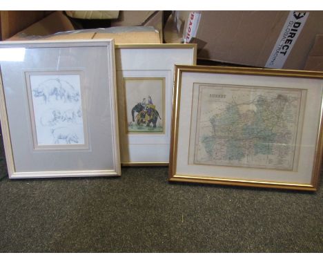
Lot 307

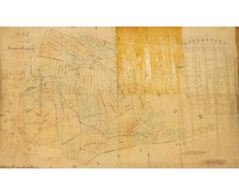
A MAP OF THE LORDSHIP OF SMEETON WESTERBY, 1850, by Wm. Buzzard, Surveyor, Kibworth, in pen and coloured ink, on canvas backing, the fields named and numbered with corresponding proprietors, in a tin metal storage tube. Tin case 134cm longFootnote: it is known that in 1846 (until c.1876) H.H.H. Hungerford was Lord of Smeeton Westerby Manor.  The village is in the parish of Kibworth, Leicestershire

Lot 308

SAXTON (CHRISTOPHER), ENGLAND AND WALES, 1579, a hand-coloured engraved map, framed. Plate 38.5cm by 49cmCONDITION REPORTMount torn, needs re-framing, signs of damp damage

Lot 154

Box - WWII RAF medals (possibly replicas), loose ribbons, German medals, buttons and badges, signed Douglas Bader small card, Picture Post magazines, Leonard Cheshire autograph, US Army cloth insignia badges (possibly replicas), photocopy flying logs, ARP regulations notice, other printed matter including Bacon's London map c.1930, Speedway brochures, American GI sweetheart letters, and other loose items

Lot 298

John Ward Dunsmore (American 1856-1945, exh. 1884-1888) "A Lady with Fan" , signed, grisaille heightened with pen and ink, 36cm x 25.5cmtogether with 2 prints after Aubrey Beardsley a small map of Waradin and one other

Lot 1097

A map of the 'Hundreds of Westgate, Whitstable, Blengate and Preston' hand coloured, framed and glazed, 36cm x 47.5cm

Lot 1137

A French reproduction map of France "Fromaiges Et Vignobles... Pais de Cocagne", framed and glazed, 34cm x 47cm

Lot 1140

A reproduction map of England after Blaeu, framed and glazed, 45cm x 55cm

Lot 1230

A box of maps and topographical books to include Jackson's map of Middleton Hunt, map of the General Omnibus routes no.6 1928 etc

Lot 1280

Three pictures and prints including Indian watercolour, pencil drawing of pigs and a map of Surrey

Lot 1329

Two vintage items - Edward VIII 1937 coronation serviettes and a folding map of London

Lot 1468

A collection of small map prints, William Piers Bristol to Weymouth by Thos Gardner, a map of Somerset by T. Kitching, a map of Leicestershire, The Road from London to Harwich. All framed and glazed (one glass broken) (4)

Lot 1324

A mid century reproduction of a 17th century John Speed map of Suffolk. Framed & glazed, frame size approx. 47.5cm x 60cm.

Lot 206

Connoisseur steel reproduction hand produced copy of Robert Morden's Map of Cumberland, 30 cm x 35 cm (Ref 1056)

Lot 285

A relief map of The Lake District, 79 cm x 70 cm

Lot 662

Vintage 2 tier occasional table with North England map design

Lot 338

MITCHELL, A Road Map of Scotland, complete, large numerals, VG to EX, 50

Lot 349

OGDENS, Sectional Cycling Map, complete, G to VG, 50

Lot 400

The Drake silver medal map, Michael Mercador 1589, a limited edition National Maritime Museum medallion, cased

Lot 436

A Tombleson's map of the Thames and seven colour prints, Thames scenes, in gilt strip frames

Lot 1678

A FRAMED MAP OF WESTMORLAND

Lot 1833

AN ASSORTMENT OF HOUSEHOLD CLEARANCE ITEMS TO INCLUDE CERAMICS AND A MAP ETC

Lot 456

A VINTAGE WAR MAP NO.2 OF THE WESTERN FRONT PUBLISHED BY DAILY TELEGRAPH 1939 - 1945 WORLD WAR II

Lot 57

A pair of Keanes Jewellery map cuff links, with chain and bar link, yellow metal, stamped 585, 8.8g all in, boxed.

Lot 667

After Robert Morden. Huntingdonshire framed map, 32cm x 36cm, framed and glazed.

Lot 255

Framed map of Merionethshire (Mervinia) and Montgomery (mid Wales), by P Schenk and G Valk, 49 x 35 cm. P&P Group 3 (£25+VAT for the first lot and £5+VAT for subsequent lots)

Lot 256

Framed map of Devonshire by J Archer Pentonville, London, 23 x 18.5 cm. Not available for in-house P&P, contact Paul O'Hea at Mailboxes on 01925 659133

Lot 257

Framed map of the East Indes, signed I Bell, 28 x 17.5 cm. Not available for in-house P&P, contact Paul O'Hea at Mailboxes on 01925 659133

Loading...Loading...
  • 109198 item(s)
    /page

Recently Viewed Lots