We found 109182 price guide item(s) matching your search
There are 109182 lots that match your search criteria. Subscribe now to get instant access to the full price guide service.
Click here to subscribe- List
- Grid
-
109182 item(s)/page


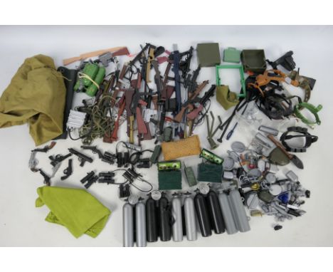
Lot 401
Palitoy - Hasbro - Action Man - GI Joe - Others - A loose collection of predominately vintage Action Man weapons and accessories. Lot includes Lewis machine gun; field radios; mess tins; primus stove; map canisters; colt .45 pistol; tent; chair; Luger; flare gun; flamethrower, binoculars; entrenching tools; jungle knife; grenades; paddles and similar. Items show age and play related wear ranging Fair - Very Good overall, some broken or with missing parts and are unchecked for completeness. (This does not constitute a guarantee)


Lot 373
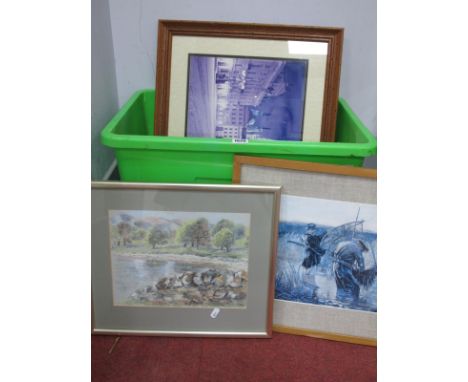
TWO BOXES OF CERAMICS, SUNDRIES AND BRASSWARE, to include a Tunbridge Ware box, a bur walnut music box (mechanism not working), an Italian shoe horn with a faux ivory stretching cat, a hand painted box decorated with a continental lake scene, a vintage Cadbury, Bournville cocoa tin in the form of a wooden chest, a similar tin, brass horse ornaments, a silverplate chamber stick, brass candlesticks, green glass solitaire pieces, two large vases and two large jugs, two late 19th century porcelain plates decorated with blue floral swags on a white ground marked B.L on the back (chips and marks) a Royal Doulton Coaching Days Blue Sky variation Pekoe covered sugar bowl (small crack and chip near the rim), a Smiths wooden cased mantel clock, a boxed set of vintage Merit 'Solitaire', Collins linen Standard map of London, together with a linen map of Gloucester & the Cotswolds, embroidered table linen, etc. (s.d) (2 boxes + loose)

Lot 683
A FRENCH SEQUINNED EVENING BAG, probably 1920s/30s, the front having flowers and scrolling borders, the rear decorated with a map of France, all in sequins outlined with seed beads, metal clasp and chain handle, 'Made in France' label sewn in interior, width 16cm (1) (Condition Report: appears in generally good condition, some missing sequins and beads, especially to upper front)


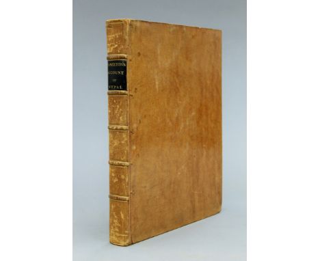
Lot 43
Hamilton (Francis), An Account of the Kingdom of Nepal and of the Territories Annexed to this Dominion by the House of Gorkha, Archibald Constable, 1819, first edition, 4to, folding map and 7 plates, five folding, contemporary calf, label, some foxing. One of the earliest comprehensive accounts of Nepal.
Lot 55
Joutel (Henry), A Journal of the Last Voyage Perform'd by Monsr de la Sale to the Gulph of Mexico, to find out the Mouth of the Missisipi River, printed by A Bell, 1714, first English edition, folding map, contemporary calf, worn, front cover detached. Sabin 36762, Church 859. 'First accurate delineation of the river', Howes.
Lot 63
Lumsden (Lieut Thomas), A Journey From Merut in India to London Through Arabia, Persia, Armenia, Georgia, Russia, Austria, Switzerland and France during the years 1819 and 1820, Black, Parbury et al, 1822, first edition, with coloured folding map and plate, VII, 272 and 12pp, full contemporary calf, little rubbed.
Lot 84
Peter (John), A Relation or Diary of the Siege of Vienna, William Nott, 1684, 2 folding maps, 4to, later boards, cropped, worn, pp 112, pages 61-64 skipped in pagination; together with Grimston (E), Translator A True Historie of the Memorable Siege of Ostend and What Passed on Either Side, Edward Blount, 1604, 4to, contemporary calf, worn, lacks map and plates.

Lot 85
Pitman (Robert Birks), A Succint View and Analysis of Authentic Information Extant in Original Works on the Practicability of Joining the Atlantic and Pacific Oceans by a Ship Canal Across the Isthmus of America, J M Richardson, J Hatchard, 1825, 8vo, folding map, contemporary calf by Henington, label, little rubbed. Sabin 63055.
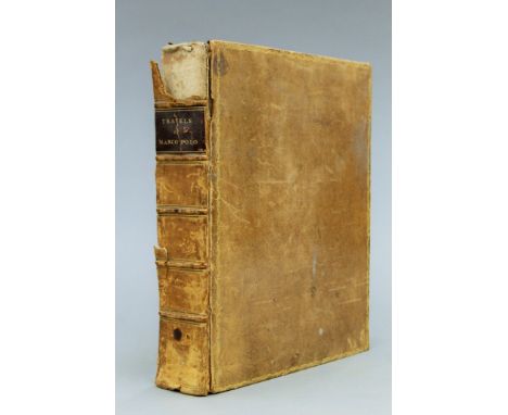
Lot 86
Polo (Marco), The Travels of Marco Polo, A Venetian in the thirteenth century, being a description of that early traveller of remarkable places and things in the eastern parts of the world, translated from the Italian, with notes by William Marsden, printed for the author, 1818, first English edition, 4to, pp LXXX and 782 and (iii), map, contemporary calf, spine partly detached and defective.
Lot 110
Taylor (Thomas), England Exactly Described or a Guide to Travellers in a Compleat Sett of Most Correct Mapps of Counties in England... According to Mr Ogilby's Survey, Theo Bakewell, n.d., with folding title, 4 folding tables, 40 country maps (on 39 plates), with extra map of Ireland not list in Chubb, all folding, contemporary calf, rubbed. A scarce issue.


Lot 311
A good selection of pictures and prints to include:a mid-19th century pastoral watercolour;Gillean Whitaker R.A. -'Bullfinch', watercolour, oval glazed gilt frame;a set of five etchings to include 'Buckingham Palace';an early 18th century hand-coloured map engraving of Warwick, glazed Hogarth frame;a 19th century shoulder-length portrait of a girl wearing pearls and lace dress, monogrammed KC lower left, later gilt frame;a still-life study of a bird's nest with eggs and pansies surrounding, signed indistinctly lower right, glazed gilt frame.


Lot 178
λ MARY ADSHEAD (BRITISH 1904-1995)A CULINARY MAP OF GREAT BRITAIN (DESIGN FOR GLASS MAP OF PARIS EXHIBITION, 1937)Bodycolour and pencil Annotated to the margins78 x 60cm (30½ x 23½ in.)Unframed Provenance:Liss Llewelyn Fine Art, London Condition Report: Unframed. This work is annotated on the reverse 'damaged in transit'. The work has losses to the edges and corners. There are a number of tears to the sheet, most notable to the lower left quadrant. There is some evidence of water damage scattered throughout the sheet and evidence of paint splashes from the upper edge travelling down the sheet passing through 'scones'. Would suggest viewing the work in person before bidding. Condition Report Disclaimer

Lot 175
JOHNNIE WALKER 500 YEARS SPECIAL COLLECTION AND THE CLASSIC MALTS 2 MINIATURE SETS JOHNNIE WALKER 500 YEARS SPECIAL COLLECTION MINIATURE SETBlended whisky.Red Label - 43% ABV / 5cl12 Year Old Black label - 43% ABV / 5cl15 Year Old Gold Label - 43% ABV / 5clCardhu 12 Year Old - 40% ABV / 5clLiqueur - 40% ABV / 5clCLASSIC MALTS MINIATURE COLLECTIONSingle malts.Cragganmore 12 Year Old - 40% ABV / 5clDalwhinnie 15 Year Old - 43% ABV / 5clGlenkinchie 10 Year Old - 43% ABV / 5clOban 14 Year Old - 43% ABV / 5clTalisker 10 Year Old Map Label - 45.8% ABV 5clLagavulin 16 Year Old White Horse - 43% ABV / 5clQty: 2

Lot 188
JOHNNIE WALKER 500 YEARS SPECIAL COLLECTION AND THE CLASSIC MALTS 2 MINIATURE SETS JOHNNIE WALKER 500 YEARS SPECIAL COLLECTION MINIATURE SETBlended whisky.Red Label - 43% ABV / 5cl12 Year Old Black label - 43% ABV / 5cl15 Year Old Gold Label - 43% ABV / 5clCardhu 12 Year Old - 40% ABV / 5clLiqueur - 40% ABV / 5clCLASSIC MALTS MINIATURE COLLECTIONSingle malts.Cragganmore 12 Year Old - 40% ABV / 5clDalwhinnie 15 Year Old - 43% ABV / 5clGlenkinchie 10 Year Old - 43% ABV / 5clOban 14 Year Old - 43% ABV / 5clTalisker 10 Year Old Map Label - 45.8% ABV 5clLagavulin 16 Year Old White Horse - 43% ABV / 5clQty: 2Low fill levels in Classic malt set.

Lot 82
30 ASSORTED WHISKY MINIATURES INCLUDING LAGAVULIN 16 YEAR OLD WHITE HORSE 30 ASSORTED WHISKY MINIATURESThis lot includes: Dalmore 12 Year Old, Highland Park 12 Year Old 1990s, Lagavulin 16 Year Old White Horse, Littlemill 8 Year Old and a Talisker 10 Year Old Map Label.Various ABVs / Each approximately 5clQty: 30Various fill levels.


Lot 181
COLLECTION OF 17TH CENTURY & LATER COUNTY MAPS, to include “Suffolke described and divided into hundreds” by John Speede, “Glamorgan Comitatus Qui Olim Pars Silvrvm”, “Cardiganshyre described with the due forme of the shiretown as it was surveyed by I.S. Anno, 1610” by John Speede, “Comitatus BrechiniÆ, Breknoke”, “Brecknock Comitatus Pars Olim Silvrvm”, “An Accurate Map of Devonshire Divided into its Hundreds” by Eman. Bowen, “An Accurate Map of Glamorganshire” by Thomas Kitchin

Lot 6
LLOYD (JOHN). Old South Wales Iron Works 1906; Historical Memoranda of Breconshire Vol.I 1903; Historical Memoranda of Breconshire Vol. II 1904; Historical Memoranda of Breconshire Vol.II 1904 (4)Comments: spine on Old South Wales Iron Works badly faded, spine buffed, small hole in spine, fold out map included in this edition partially ripped, spine on green edn. of Memoranda of Breconshire Vol.II 1904 badly faded and beginning to fray, map included in this volume is worn and partially torn where folded which has been fixed with sellotape, scratches and marks to outer cover, some page corners in of Historical Memoranda of Breconshire Vol.I 1903 with minor scuffing and rips, binding is partially coming away from spine on Historical Memoranda of Breconshire Vol.II 1904, spine on Memoranda of Breconshire Vol.II 1904 badly faded and beginning to fray, map included in this volume is worn and partially torn where folded which has been fixed with sellotape, scratches and marks to outer cover

Lot 176
MURCHISON (RODERICK IMPEY). The Silurian System Founded on Geological Reasearches in the Counties of Salop... two vols, 1st edition, John Murray, 1839, complete apart from the large hand coloured map, a seminal work on geology, half Morocco, marbled covers, inscribed 'Hereford' in ink to flyleaf (2)Comments: some water-staining to vol. I upper margin and water staining to some plates in vol. II


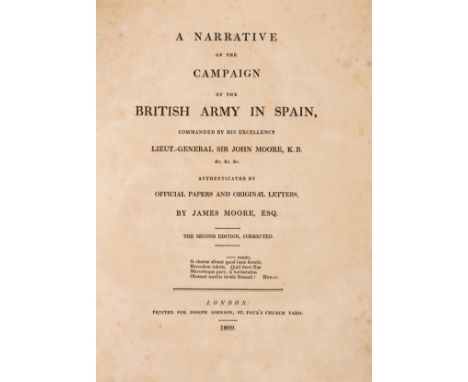
Lot 102
Military.- Spain.- Moore (James) A Narrative of the British Army in Spain, second edition, engraved portrait frontispiece, 2 folding engraved maps, 1 with hand-colouring and a few paper repairs to verso, some light spotting, nineteenth-century half calf, for Joseph Johnson, 1809 § Neale (Adam) Letters from Portugal and Spain, comprising an account of the operations of the armies..., first edition, engraved map frontispiece, several engraved plates, bookplate, some foxing, nineteenth-century half calf, for Richard Phillips, 1809 § Stothert (Capt. William) A Narrative of the Principal Events of the Campaigns of 1809, 1810 & 1811 in Spain and Portugal, first edition, engraved folding map frontispiece (light off-setting), single leaf publisher's advertisement at front, original boards with paper label to spine, joints cracked but firm, rubbed, for P. Martin, 1812 § [Daniel (John E.)] Journal of an Officer in the Commissariat Department of the Army: comprising a narrative of the campaigns under His Grace the Duke of Wellington, in Portugal, Spain..., first edition, list of subscribers, errata leaf, original boards, spine worn with chip to foot, stain to upper cover, 1820, 4to & 8vo (4)

Lot 99
France.- Girard (Xavier) Plan de la Ville de Paris, Divise en 12 Arrondissemens, en 48 Quartiers..., large folding plan of pre-Haussmann Paris, with alphabetical index to left and right margins, engraving with original hand-colouring, sheet 590 x 985 mm (23 1/4 x 38 3/4 in), dissected and mounted on linen, some folds splitting, surface dirt and minor browning, folding with publisher's printed label to end, lacking slipcase, 8vo, J. Goujon, 1826; together with E. Cottin's Tableaux itinéraires des distances de Paris aux principales villes de France, et à toutes les capitales d'Europe. Présentant sous, title, folding map of France, paper covered boards, spine splitting, very worn, 8vo, 1821 (2)
Lot 258
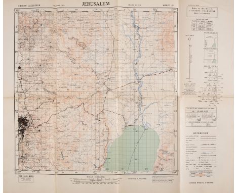
NO RESERVE Holy Land.- Survey of Palestine.- Collection of 20 maps from various editions, including map sheets 2, 3, 5, 7, 9, 10, 11, 12, 13 from a series of 16 on a scale of 1:100,000 revised and published in 1944-45, and 9 further map sheets from earlier editions on scales of both 1:100,000 and 1:20,000, some bearing 'Not to be published' in the header, and 2 separate maps sheets from the 3-part Trans-Jordan survey, zincographs printed in colours, various sizes, between 490 x 590 mm (19 1/4 x 23 1/4 in) and 1100 x 650 mm (43 1/4 x 25 1/2 in), some mounted on cloth supports, surface dirt and browning, signs of use, all folding, 8vo, mainly circa 1939-1945.

Lot 271
NO RESERVE Mining.- Mining Leases. Kalgoorlie (Hannan's Find) East Coolgardie Goldfield Western Australia, folding lithographed map, small tear along fold, 1020 x 730mm., 1901; and 10 others printed ephemeral relating to mining etc., including a "Map of the Gold Coast Issued by the Financier & Bullionist", and a South Africa Cape Colony Handbook, 1900, v.s., v.d. (11).
Lot 251
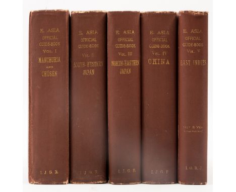
*** Please note, the description of this lot has changed ***Asia.- Official Guide to Eastern Asia (An), 5 vol., first edition, maps, most folding, photographic plates, illustrations, map of Shanghai detached from vol.4, map of Singapore in vol. 5 with large tear from gutter into the sea, light marginal toning but a very crisp set overall, original cloth, gilt, t.e.g., light rubbing and fraying to spine ends, 8vo, Tokyo, 1913-17.⁂ Scarce to find in a complete set. A series of thorough guide books in English printed at the Tokyo Tsukiji Type Foundry for travellers from Europe and America, tourists as well as "business men and capitalists" (Preface).
Lot 273
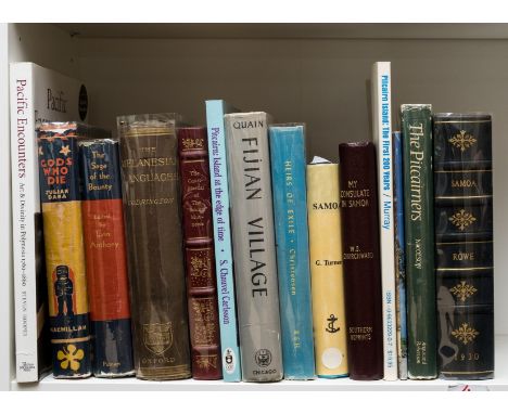
Pacific Islands.- Mutiny on the Bounty.- Codrington (Robert) The Melanesian Languages, first edition, folding map frontispiece, ex-library copy with stamps and markings, original cloth, a little scuffed and frayed at spine ends, Oxford, Clarendon Press, 1885 § Anthony (Irvin) The Saga of the Bounty, third impression, map endpapers, original cloth, dust-jacket, corner to upper flap torn away, some nicks and tears to upper edge and spine, joints a little rubbed, New York, 1936 § Rutter (Owen) The Court-Martial of the "Bounty" Mutineers, original morocco-backed cloth, privately printed for members of The Notable Trials Library, Alabama, 1989; and 11 others, similar, v.s. (14)
Lot 111
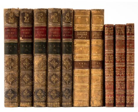
Spain.- Laborde (Alexandre de) A View of Spain; comprising a descriptive itinerary of each province, 5 vol., 29 engraved maps and tables, many double page or folding, spotting throughout, later half calf with morocco labels to spine, vol. 1 upper cover detached, a little scuffed, 1809 § Dunlop (John) Memoirs of Spain, 2 vol., endpapers (and preliminaries to vol. 2) with some light spots, contemporary calf, gilt with morocco labels, a little scuffed, 1834 § Semple (Robert) Observations on A Journey through Spain and Italy to Naples, 2 vol., folding engraved map, a few spots, 1808; A Second Journey in Spain, several engraved plates, 1812, together 2 works in 3 vol., both second editions, ink ownership inscriptions, occasional light spotting, uniformly bound in red half morocco with original boards, spines gilt, a little sunned, 8vo (10)
Lot 115
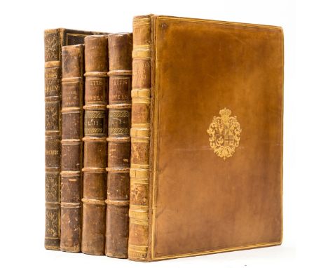
Spain.- Swinburne (Henry) Travels Through Spain in the years 1775 and 1776, folding engraved map (paper repair to fold on verso), 13 engraved plates (as called for) and 4 additional plates, some light off-setting, initial ff. with some very faint spots, contemporary calf with gilt crest to upper cover, rebacked with original back-strip laid down, P. Elmsly, 1779 § Jacob (William) Travels in the South of Spain, folding frontispiece, 12 plain aquatint plates, bookplate, occasional spotting and off-setting, a very very small worm holes to top edge (affecting blank margins only), contemporary calf, a little worn at joints and extremities, for J. Johnson, 1811 § Locker (Edward Hawke) Views in Spain, half-title, 60 lithographed plates, light foxing, upper hinge broken, contemporary morocco, gilt, spine rubbed, [Abbey Travel 147], John Murray, 1824 § Baretti (Joseph) A Journey from London to Genoa, 2 vol., half-titles, vol. 1 with small worm holes to lower blank margin first half (not affecting text), contemporary calf with morocco labels to spine, for T. Davies and L. Davis, 1770, all first or first English editions, 4to (5)
-
109182 item(s)/page