We found 109182 price guide item(s) matching your search
There are 109182 lots that match your search criteria. Subscribe now to get instant access to the full price guide service.
Click here to subscribe- List
- Grid
-
109182 item(s)/page


![[MAPS] Blome, Richard (1635-1705), 'A Mapp of... Rutland', engraved county map, hand-coloured, 23cm x 29.5cm.](https://cdn.globalauctionplatform.com/43456175-3a8b-463d-b868-a7ba00a6a9a6/d0f28151-bac7-4f8a-a1b8-c931ed4d54b1/468x382.jpg)

![[Drayton (Michael)] Glamorganshyre and Monmouthshyre, nd. (1612-22), hand-coloured map, 240mm x 313mm, mounted, framed and gl](https://cdn.globalauctionplatform.com/b2b13407-ec39-4ad3-86c9-a7b5011196d5/fe3647c4-5a1e-4f0e-e836-2ffdc8f7afe6/468x382.jpg)
![GEOLOGICAL MAPS No.XLIV [44, Worcestershire/Gloucestershire]; No.LV [55, Herefordshire/Worcestershire]; No.LXXIV [74, Llangol](https://cdn.globalauctionplatform.com/b2b13407-ec39-4ad3-86c9-a7b5011196d5/ce0da89d-7702-4b3a-907b-f456973cff43/468x382.jpg)
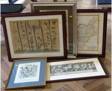
Lot 86
GEOLOGICAL MAPS No.XLIV [44, Worcestershire/Gloucestershire]; No.LV [55, Herefordshire/Worcestershire]; No.LXXIV [74, Llangollen/North Wales]; No.LXXXII [82, Nottinghamshire/Derbyshire/South Yorkshire], 1860s, Geological Survey of Great Britain; four hand-coloured engraved geological maps, sectionalized and mounted on linen (folding); nos. 44 and 82 printed borders 630 x 730mm, nos. 55 and 74 in frames 730 x 1030mm. Early issues in original colour, fault lines highlighted in white, based on the Ordnance Survey one inch to one mile map. Sheet 82 with (part of) official blindstamp for January 1863, three sheets with 'Price 2s' upper right, keys in the margins (4)

Lot 75
Nicolson (Joseph) and Burn (Richard) The History and Antiquities of the Counties of Westmorland and Cumberland, 1777, two volumes, quarto, two folding maps, contemporary calf gilt (board detached) Hutchinson (William), The History of the County of Cumberland, and some Places Adjacent .., 1794, two volumes, quarto, folding maps (taped repairs, tears), plates, contemporary calf (worn); Lysons (Daniel & Samuel), Magna Britannia ... Vol 4: Cumberland, 1816, quarto, map, plates, diced calf with functional re-back (5)


Lot 95
Horwood (R.) Plan of the Cities of London and Westminster, the Borough of Southwark, and Parts adjoining, Shewing every House, 1792-9, first edition, folio, thirty-two single page engraved sheets, 705mm x 555mm, A1 and B1 are full map plates, G4 issued without subscribers lists, (see Howgego 200-1), some foxing and dust soiling to sheets, particularly to margins, one corner torn outside of impression, well worn half calf, lacking backstrip, boards detached
![Speed (John) and Norden (John) Midle-Sex, described with the most Famous Cities of London and Westminster, nd. [c1676] Basset](https://cdn.globalauctionplatform.com/b2b13407-ec39-4ad3-86c9-a7b5011196d5/8f2c8d80-f3f1-4c19-8824-ec94dfe7baa5/468x382.jpg)


![Ogilby [John] The Traveller's Guide: or, A Most Exact Description of the Roads of England. Being Mr. Ogilby's Actual Survey,](https://cdn.globalauctionplatform.com/b2b13407-ec39-4ad3-86c9-a7b5011196d5/a68263a4-6462-4180-b501-330a482958c3/468x382.jpg)
Lot 99
Ogilby [John] The Traveller's Guide: or, A Most Exact Description of the Roads of England. Being Mr. Ogilby's Actual Survey, and Mensuration by the Wheel ...., 1699, Abell Swall, folding map, seperate title to tables (1699), pages tanned with some foxing, small abrasion to p. 91, minor early annotation, later calf gilt


Lot 101
Bell (John Thomas William) Plan of the Hartlepool Coal District in the County of Durham. Including part of the Wear District in the same County being the First of a Series of Plans of the Great Northern Coalfield ..., 1843, large hand-coloured printed map, image 800mm x 1045mm, linen-backed, some outline colouring appears a later addition, rolled

Lot 97
Greenwood (C. and J.) Map of London, from An Actual Survey made in the Years 1824, 1825 & 1826, August 1827, Greenwood Pringle, first edition, large engraved map on six sheets, each circa 660mm x 750mm, central vertical fold to each, one sheet split into two, edges torn and frayed with loss to margins, dust soiled [Howgego 309 (1)]

Lot 72
Hudson & Nicholson (edit.) A Complete Guide to the Lakes, Comprising Minute Directions for the Tourist with Mr. Wordsworth's Description of the Scenery of the Country ...., 1842, frontis, hand-coloured folding map, plates, original cloth; Kelly's Directory of Cumberland and Westmorland, 1910, two folding colour maps, original cloth; Edmonds (Harfield H.) & Lee (Norman N.), Brook and River Trouting, nd. [1916], plates present as called for, original cloth; with one other (4)

![[Hondius] Hondii (Henrici) Territorio Perugino, nd., Amsterdam, hand-coloured engraved map, impression 378mm x 495mm, some ta](https://cdn.globalauctionplatform.com/b2b13407-ec39-4ad3-86c9-a7b5011196d5/b0d2e7f8-52fc-409e-9f91-3a6603438282/468x382.jpg)

![Saxton (Christophorus) and Hole (Gulielmus) Eboracensis Comitatus pars Occidentalis vulgo West Riding, nd. [1607], uncoloured](https://cdn.globalauctionplatform.com/b2b13407-ec39-4ad3-86c9-a7b5011196d5/b0dde4e6-fd19-481a-a591-99f98a2b2113/468x382.jpg)
Lot 98
Saxton (Christophorus) and Hole (Gulielmus) Eboracensis Comitatus pars Occidentalis vulgo West Riding, nd. [1607], uncoloured engraved map, impression 268mm x 323mm, verso Latin text, page 562 and blank [559], signature Kkkk3 on blank page, mounted, framed, glazed front and rear [Whitaker 10, 'the earliest individual map of the Riding']
![Speed [John] & Saxton (Christopher) Norfolk, A Countie Florishing & Populous, Described and Devided with the Armes of such No](https://cdn.globalauctionplatform.com/b2b13407-ec39-4ad3-86c9-a7b5011196d5/1003b559-2e93-470a-f4d4-051b15f63bb3/468x382.jpg)
Lot 107
Speed [John] & Saxton (Christopher) Norfolk, A Countie Florishing & Populous, Described and Devided with the Armes of such Noble Familes as have Borne the Titles Therof, nd [c1611], J.S. & S.H. [Sudbury and Humble], hand-coloured engraved map, impression, 382mm x 510mm, English text verso, pages 36/35, signature Y, initial of saint with animal, framed, glazed front and rear


![17th Century French School. "Piemonte et Monferrato [sic]", Map, Unframed, 16.5" x 20.5".](https://cdn.globalauctionplatform.com/775cc218-deec-4b90-955c-a7b40101ee21/bc6a077f-3c4d-4c48-a039-af518f988706/468x382.jpg)

Lot 280
Golf Club and Course Guide Books from 1938 onwards to include "50 Miles of Golf London" 2nd edition 1938 complete with fold out map to the rear, original decorative boards together with numerous advertisements to the front and rear, "Links Along The Line-The Story of the Development of Golf Between Liverpool and Southport" by Harry Foster 1st edition 1996 c/w (G), "By Yon Bonnie Links!" by Sam Morley 1st ed 1990 c/w dust jacket and "Scotland's Golf In Days of Steam" 1st edition 2000 in the original wrappers (G) (4)

Lot 367
Macdonald, Charles Blair -"Scotland's Gift Golf - Reminiscences 1872-1927" 1st ed 1928 published Charles Scribner's Sons, NY in the original red and gilt cloth boards and spine (very faded, stained in places and worn) c/w the original frontis tissue guards together with various other colour plates and photo lithographs and fold out map of the National Golf Links of America to the rear. Owners name hand written to front end plate and some scoring to the lower left hand corner) internally generally clean (A/F)


Lot 25
A set of forty Elizabeth II silver circular medallions - "The Ancient Counties of England", each 1.75ins diameter, issued by The Birmingham Mint to commemorate the Boundary Changes to the Ancient Counties of England on 31st March 1974 (weight 56ozs), complete with reproduction map and contained in stained wood fitted case, 18.5ins x 12.5ins x 4ins high


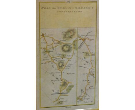
Lot 98
A PAIR OF ATTRACTIVE HAND COLOURED MAPS, 19th century, one showing the Road from Dublin to Kildare and Portarlington, and a further map verso, with details of the above; and another hand coloured map, uniformly framed, the Road from Limerick to Ennis, continued from Six-Mile Bridge, and verso with a map of the Road from Limerick to Galway, each 9" (23cm) x 5" (12cm). (2)

-
109182 item(s)/page