We found 109198 price guide item(s) matching your search
There are 109198 lots that match your search criteria. Subscribe now to get instant access to the full price guide service.
Click here to subscribe- List
- Grid
-
109198 item(s)/page


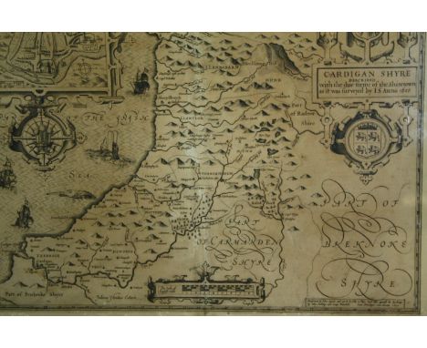
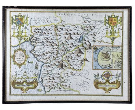
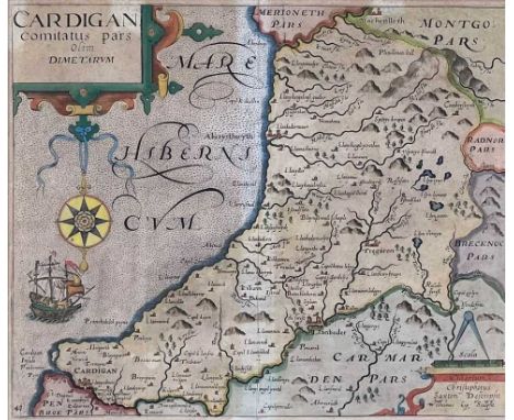
Lot 88
Cardiganshire. Speed (John), Cardigan Shyre Described with the due forme of the Shire Town as it was Surveyed by J. S. Anno 1610, John Sudbury & George Humble, circa 1611, uncoloured engraved map, inset town plan of Cardigan, large strapwork cartouche, mileage scale and compass rose. Framed and glazed. H.51 W.63cm.


Lot 9167
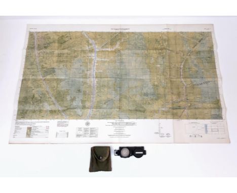
WW2 British Paperwork collection comprising of: US Army Short Guide to Great Britain Booklet: British Army Welfare Services Map of Paris printed on back of a German Map: Urdu Companion 1941: Vauxhall Motors "For B.F.s" vehicl handbook 1944: Control Commision German NAAFI Operated Clubs Guide: Book "Technical Instruction for Marine Radio Officers" 1950: Pre WW1 RGA Paperwork: Map of Bremen April 1945, etc.


Lot 281
King and Country - Three boxed figures from the King and Country WWII 'Air Force' series. Lot consists of AF02 USAAF Pilot with Map; RAF04 RAF Sgt Pilot Ginger Lacey; and RAF24 RAF Policeman. Figures appear to be in Mint condition in Excellent - Near Mint boxes with some minor storage wear. (This does not constitute a guarantee) (K)


Lot 423
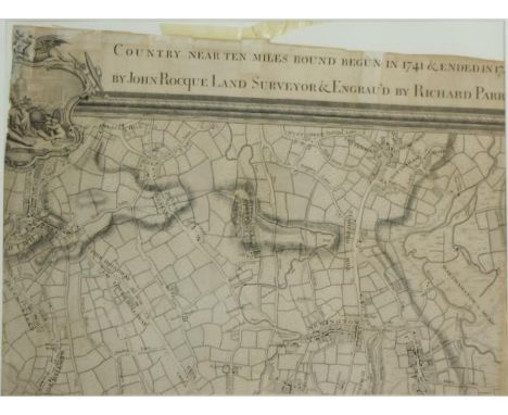
THREE BOXES OF MISCELLANEOUS SUNDRIES, to include eight framed pictures, seventeen 1970's Mr. Men books by Roger Hargreaves, children's annuals, walking sticks, empty perfume bottles, three Folio Society books, comprising 100 Greatest Paintings, Kidnapped, Revolt in The Desert, six Cassell volumes of The Second World War by Winston Churchill, 'The Times' linen backed Sheet 6 Motoring Map of England, etc. (s.d) (3 boxes)


Lot 36
Excellent volume from Hetzel's Au Steamer (Red macaron) French edition of the Voyages Extraordinaires by writer Jules Verne. It includes the novel L'Etoile du Sud (The Vanished Diamond, or The Southern Star) with 60 illustrations and a map by Leon Benett. Collection Hetzel, Bibliotheque d'Education et de Recreation, published by Pierre Jules Hetzel et Cie, Paris. Artist: Jules Verne (French 1828-1905)Issued: c. 1895Dimensions: 7.25"W x 10.75"H x 0.60"DManufacturer: HetzelCountry of Origin: FranceCondition: Age related wear. Some gild loss on the macaron.

Lot 31
Outstanding volume from Hetzel's Au Steamer (Red macaron) French edition of the Voyages Extraordinaires by writer Jules Verne published between 1892 and 1905. It includes the novel De la terre a la Lune. Trajet direct en 97 heures 20 minutes (From the Earth to the Moon) with illustrations and one map by Montaut. Includes the new catalogue for 1895. Collection Hetzel, Bibliotheque d'Education et de Recreation, published by Pierre Jules Hetzel et Cie, Paris. Artist: Jules Verne (French 1828-1905)Issued: 1895Dimensions: 7.40"W x 10.60"H x 0.50"DManufacturer: HetzelCountry of Origin: FranceCondition: Very good. Minor foxing. Minor paint loss on the steamer hull.

Lot 29
Single volume from Les Mondes Connus et Inconnus published by edition house Hachette et Cie from Hetzel's Les Voyages Extraordinaires by Jules Verne. It includes the novel L'Etoile du Sud (The Vanished Diamond, or The Southern Star) with 60 illustrations and one map by Benett. Ink signature on first page: L. Dumont. Artist: Jules Verne (French 1828-1905)Issued: 1922Dimensions: 7.25"W x 10.75"H x 0.80"DCountry of Origin: FranceCondition: Good. Gild and color loss. Browning of pages.


Lot 176
Vintage Railway Posters Collection: Loch Lomond, British Rail Safety, Pullman Diesel Services.The collection features an original Loch Lomond Railway Poster Map by Jordison & Co for British Railways (Scottish Region) B-32654, a British Rail safety poster (P.2063) cautioning Train Spotters, and a Pullman Diesel Services on the Western Region Original Poster by British Railways (Western Region) PR.232/61 stamped "Vincent Power"


Lot 108
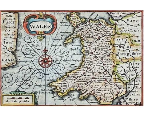
PIETER VAN DEN KEERE coloured antiquarian map entitled in cartouche 'Wales', showing the whole of Wales and a small section of Ireland, with inset scale of miles, compass and other illustrations, circa 1620s, 8 x 12cmsProvenance: the Welsh art collection of award-winning television producer, the late Pat Llewellyn (1962-2017), by descentComments: framed and glazed, ready to hang

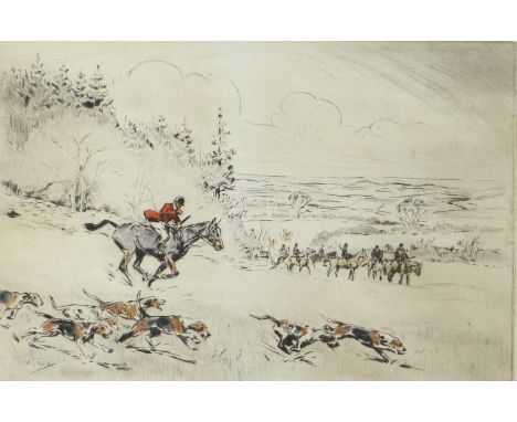
Lot 1143
Tom Carr (1912-1977)''Breaking Cover''Signed, inscribed and numbered 65/75, etching, together with a collection of hunting themed prints to include "Meynell Hunt" after Lionel Edwards, "Sandown / Asking 'em the question" after Charles Johnson Payne "Snaffles", a map of the "Foxhunts of Great Britain", etc... 26cm by 36cm and various other sizes (6)
-
109198 item(s)/page