We found 109182 price guide item(s) matching your search

Refine your search

Year

Filter by Price Range
  • List
  • Grid
  • 109182 item(s)
    /page

Lot 369

An 18thC map of Venice and other parts of Italy, after Matthew Seutter, Augsburg Circa 1730, 48cm x 58cm, and map of Italy, after Johann Homann. (2)

Lot 762

A nest of three teak retro G-Plan style tables, each with a hammered copper top, 53cm W, and a nest of three retro style tables, each with brass mounts, the tops decorated with brass and a central printed map, 63cm W.

Lot 1019

Games. Two games, comprising Touring Europe, A fascinating and instructive map game by Geographia (playing pieces boxed); & Victory Constructional Dog Show (boxed)

Lot 1177

Pickwick Papers. A hand drawn map, titled 'A Series of Maps, Drawn to Illustrate the Pickwick Papers', signed C.M.N.' & dated July 1908, depicting London, Suburbs, Kent, Bury St Edmunds & England, image size 44cm x 61cm, mounted on board

Lot 1332

Map/Plan Stowmarket, Great Finborough Hall Estate by R.C Knight and Sons with estate boundaries in colour, minor holes in some of the creases, 1930's estate sale. 

Lot 1338

Sampson Low, Marston & Company (publisher). The District Map of Greater London and Environs, 1st edition, 1902, folding colour map, 66.5cm x 106cm approx., original cloth backed decorative boards

Lot 1341

Robertson (William). The History of America, volume 1 only, 4th edition, 1783, folding engraved South America map frontispiece, folding engraved map of the Gulf of Mexico, contemporary tree calf gilt, 8vo

Lot 1346

Suffolk map, hand coloured c1787 details of script includes history, twenty two hundreds and thirty market towns, viz. Ipfwich, Aldborough, Leotoff, Bilfton, Halefworth, Neyland inc Frame.

Lot 1396

Saxton (Christopher & Lea, Philip). Denbigh & Flintsh [Flintshire], Described by C.S., Corrected & amended with many additions by P. Lea, engraved hand coloured map, circa 1690, framed & glazed, image size 42cm x 56cm approx.

Lot 1397

Saxton (Christopher & Lea, Philip). Merioneth and Montgomery, Described by C.S., Corrected & amended by P. Lea, engraved hand coloured map, circa 1693, mounted, framed & glazed, image size 39cm x 52cm approx.

Lot 1400

Speed (John, 1552-1629). Flintshire, engraved hand coloured map, circa 17th Century, framed & glazed to both sides, image size 41.5cm x 53cm approx.

Lot 1401

Thomson (John). A Map of Europe with the Political Divisions After the Peace of Paris and Congress of Vienna, Drawn & Engraved for Thomson's New General Atlas, 1816, on two sheets, hand coloured folding map, total size 126cm x 109cm approx.

Lot 1402

Saxton (Christopher & Kip, William). Denbigh Comitatus pars olim Ordovicum, engraved hand coloured map, circa 17th century, mounted, framed & glazed, image size 28cm x 33cm approx., together with Kip (William). Flint, Comitatus quem Ordovices olim Incoluerunt, circa 17th century, mounted & framed (glass missing), image size 28cm x 33.5cm approx.

Lot 1403

Yorkshire. Speed (John, 1552-1629). York Shire, published John Sudbury and G. Humble, dated 1610, engraved map, glazed to both sides, framed, image size 40cm x 53cm approx.

Lot 1404

Speed (John, 1552-1629). Denbighshire, engraved hand coloured map, circa 1610, framed & glazed to both sides, image size 41cm x 54cm approx.

Lot 1405

Norfolk. Speed (John & Saxton, Christopher). A Countie florishing & populous. Described and devided, with the armes of such noble families as have borne the titles thereof, published by John Sudbury & George Humble, circa 1627, engraved hand coloured map, framed, glazed to both sides (crack to rear pane of glass), image size 40cm x 51cm approx.

Lot 1406

Nottingham. Speed (John). The Countie of Nottingham described, the shire townes situation and the Earls there of observed, sold by John Thomas Bassett & Richard Chiswell, circa 17th Century, engraved hand coloured map, framed & glazed, image size 39cm x 52cm approx.

Lot 1407

Ioannis Ianbonii (publisher). A general plot and description of the Fennes and surrounded grounds in the six counties of Norfolke, Suffolke, Cambridge, with in the Isle of Ely, Huntingdon, Northampton and Lincolne, etc., circa 17th Century, engraved hand coloured map, framed, glazed to both sides, image size 45cm x 55cm approx.

Lot 1408

Blaeu (Jahannes, 1596-1673). Comitatus Brechiniae, Breknoke, engraved hand coloured map, circa 17th Century, framed & glazed to both sides, image size 52cm x 62cm approx.

Lot 1409

Blaeu (Jahannes, 1596-1673). Radnoria Comitatus, Radnorshire, engraved hand coloured map, circa 17th Century, framed & glazed to both sides, image size 51.5cm x 62cm approx.

Lot 1411

Jefferys (Thomas). The World Agreable to the latest Discoveries, circa late 18th Century, engraved hand coloured twin-hemisphere map, 20cm x 39cm approx., mounted, framed & glazed

Lot 1412

Morden (Robert). Somersetshire, hand coloured engraved map, circa late 17th century, framed & glazed, image size 37.5cm x 44cm approx.

Lot 1413

Folding hand coloured map 'London & Suburbs Main Line Railway', dated 1935, some tears to folds, 102cm x 127cm approx.

Lot 1414

Lincolnshire. Hondius (Jodocus, 1563-1612), The Countie and Citie of Lyncolne described with the armes of them that have bene Earles thereof since the conquest, dated 1610, engraved hand coloured map, framed, glazed to both sides, image size 38cm x 51cm approx.

Lot 977

Map jigsaw puzzles. A large collection of map jigsaw puzzles, circa 19th century & later, including England & Wales, America, France etc., mostly incomplete, varying sizes largest 70cm x 55cm approx. together with a quantity of original wooden jigsaw boxes

Lot 19

Stanyan (Temple), The Grecian History, 2 vols, engr frontis, fldg map, cf gt, 8vo, 1774; Smith (William), The History of the Peloponnesian War, 2 vols, 4th Edn, engr frontis, 2 fldg maps, cf gt, 8vo, 1805, (4).

Lot 21

Robertson (Joseph, transl.), The Adventures of Telemachus, the Son of Ulysses, 2 vols, fldg map, cf gt, 18mo, 1795; Shakespeare (William), Works, Vol VI only, Romeo and Juliet, cf gt, 18mo, 1714 and other volumes.

Lot 311

MORDEN map of North Wales and a later North Wales map

Lot 425

Box of books and a modern wall map for P&O Shipping

Lot 579

H. MOLL; A MAP OF DORSETSHIRE 18th century

Lot 580

T KITCHIN; A MAP OF DORSETSHIRE mounted and framed

Lot 319

A framed hand coloured vintage map of Suffolk, together with a brass hanging plate, (2)

Lot 408

John Cary, A New Map of South America, 1807, London published by J. Cary Engraver & Map Seller, No 181 Strand, 62cm x 53cm, together with John Cary, A New Map of Piedmont the Duchies of Savoy and Milan; and the Republic of Genoa, 1799, London published by J. Cary Engraver & Map Seller, No 181 Strand, 62cm x 53cm, (2)

Lot 579

Prints to include map of Yorkshire, Broadstairs etching, map of Westmoreland etc. (qty)

Lot 236

A small hand coloured 19th century engraved map, 'Norfolk', in Hogarth frame

Lot 292

A New map of the Isles of Guernsey Jersey &c' map of Channel Islands (12cm x 7.7cm)

Lot 294

Garnsey ot Sarina' and 'Alderney' hand coloured map of Guernsey, Sark and Alderney (18.5cm x 15.5cm)

Lot 416

4 19th century maps of Lincolnshire inc road map of Market Rasen (Rasin) to Grimsby

Lot 431

Framed 2 sided Lincolnshire map 60.5 cm x 48 cm

Lot 450

Framed map of Lincolnshire 23 cm x 28 cm (size including frame)

Lot 309

A GEORGE III CROSS STITCH MAP SAMPLER depicting England and Wales, worked by Elizabeth Legg and dated 1801, 38.5cm wide x 39.5cm high

Lot 281

A large vintage Campaign style map low table with brass fittings,

Lot 207

A selection of vintage local interest ordnance survey map prints

Lot 327

A selection of vintage map prints including Yorkshire and North Riding

Lot 194

MAP OF LONDON, vintage reproduction, framed and glazed, 91cm x 133cm.

Lot 2240

A Robert Morden antique (c1700) hand coloured Map of Warwickshire and surrounding counties (c1700).

Lot 562

An 18th century map of Cornwall: 'Cornwall from the Best Surveys 1748, from the Universal Magazine, printed for J. Hinton at The King's Arms in St. Paul's Churchyard, dated 1748, with cartouches, coats of arms and two sailing ships, uncoloured, 21 by 26cm.

Lot 564

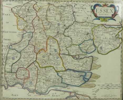
After Robert Morden (British,1650-1703): a late 17th century 1st edition map of Essex, copper plate, later hand-coloured, engraved by Sutton Nicholls, for Camden's Britannia (Swale and Churchill, London), circa 1695, with label verso for Frost and Reed Framers, dated 1946, 35 by 43cm, framed 38 by 45cm.Identified as first edition as Inworth, has been mis-spelt Inford.

Lot 565

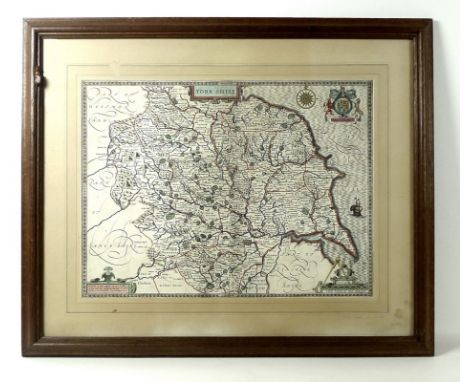
A Robert 'Mouseman' Thompson of Kilburn oak picture frame, carved with a mouse to top left side, 62 by 73cm, framing a map of Yorkshire after John Speed (British,1542-1629), with coat of arms cartouche, later hand-coloured, published by John Sudbury and George Humble, dated in the plate 1610, 39 by 52cm.
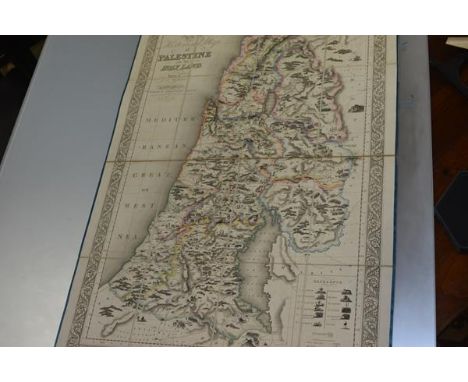
Lot 566

J. Duncan (British, 19th century): a map of Northamptonshire, hand-coloured, dated 1838, 36 by 46cm, framed 52 by 62cm, together with two modern reproductions of early maps of Yorkshire, hand-coloured with text verso, 40 by 50cm, framed 65 by 75cm. (3)

Lot 238

PALESTINE - ASSHETON, J.T., An Historical Map of Palestine or the Holy Land, Drawn by J.T. Assheton, London, Published by Samuel Leigh. Strand. Engraved by Sidney Hall, Bury Street, Bloomsbury, 1820, outline colouring, dissected and laid on linen, as issued, illustrated with vignettes of biblical events including battle scenes, the regions of the Twelve Tribes are delineated with colour, some soiling and light uniform browning, edged in silk ribbon (frayed), folding to original blue boards, total 110cm x 75.5cm, in original slip-case, extremities rubbed, corners bumped

Lot 87

Carington Bowles, Bowles's New Medium Map of Dorset Shire, engraved map with some hand colouring, published London 1785, framed. 24cm by 32.5cm

Lot 106

Talisker 10 year old single malt Scotch Whisky, designed with a map of the Isle of Skye on bottle and box, (full, sealed and boxed)

Lot 488

Original pen and watercolour "Fishermans map of salmon pools on the River Dee" Revised 1959 by I.Scott.

Lot 273

Set of early 20th century travelling beam scales, chemist bottles, books incl. Sea Charts of the British Isles & Charts of War, by John Blake, other map related books, 19th century Bay of Honduras 1871 map, Joseph Rodgers & Sons cut throat razor in case, Timpo, Britains and other plastic soldiers etc in two boxes Condition Report Click here for further images, condition, auction times & delivery costs

Lot 679

A military NATO folding map table.

Lot 689

A metal Michelin British Isles map.

Lot 1158

A framed limited edition Map of Herefordshire and a similar one of Shropshire, both signed Alan, along with a framed and mounted limited edition Print no. 75/850 'Images of Shropshire' by Penny Veys.

Lot 1235

An 1829 Virtues New Map of Kent, with slip case together with a collection of theatrical and sporting programmes, an alum of postcards and a stamp album, see images for details and condition

Loading...Loading...
  • 109182 item(s)
    /page

Recently Viewed Lots