We found 109198 price guide item(s) matching your search
There are 109198 lots that match your search criteria. Subscribe now to get instant access to the full price guide service.
Click here to subscribe- List
- Grid
-
109198 item(s)/page


![Bible [English]. The Holy Bible Containing the Old and New Testament. Newly translated out of the Originall tongues and with](https://cdn.globalauctionplatform.com/e6986aac-6ee6-4136-8dcf-a56700bd94e2/6a718921-bf86-455d-d430-53b754315eb2/468x382.jpg)
Lot 299
Bible [English]. The Holy Bible Containing the Old and New Testament. Newly translated out of the Originall tongues and with former translations diligently compared and revised by his Majesties speciall command..., [Amsterdam]: Printed in the Year 1672, additional engraved title (detached & frayed to edges), four double page engraved maps including double hemisphere map of the world showing California as an island (the map is sometimes attributed to Cornelius Danckerts or Jacob Savry and bears similarities to various maps issued by Visscher) and maps of the Holy Land, Extra Illustrated with 113 contemporary double-page engraved plates by Visscher after Bloemaert, d'Hondecoeter, de Vos, Rubens, van Heemskerck, de Brun, de Bruyn, van Winghe etc. (few torn mostly to central fold), engraved plate of Christ on the cross to upper pastedown (wormed & some manuscript inscription, each leaf of text neatly guarded to extended gutter margin, some closed tears and marginal fraying, some browning & spotting, few worm holes, near contemporary blind stamped calf, decorative brass corner pieces, lacking clasps, rebacked, boards rubbed and scuffed, folio Herbert 708 & Darlow & Moule 557, which calls for map of the World and two other maps (by Jacob Savry). (1)
Lot 3
Astley (Thomas). A New General Collection of Voyages and Travels consisting of the most Esteemed Relations which have been hitherto published in any Language, comprehending every thing remarkable in its kind in Europe, Asia, Africa and America..., 3 volumes (of four) only (lacking volume one), printed for Thomas Astley, 1745-1747, three engraved frontispieces, 201 engraved plates and maps (including many folding), plus three plates and one map in volume three supplied in facsimile, otherwise complete, occasional light offsetting, armorial bookplates removed from pastedowns, contemporary calf, gilt decorated spines, 4to (3)
Lot 368
Wyss (Johann David). The Swiss Family Robinson; Or, Adventures of a Father and Mother and Four Sons in a Desert Island, 2 vols., 3rd ed. English ed., M.J. Godwin, 1820, three engraved plates, including hand-coloured frontispiece to vol. I, folding map frontispiece to vol. II, some light spotting and offsetting, contemporary and later presentation inscriptions at front, contemporary half calf, vol. I lower cover detached and lacking most of spine, rubbed, 8vo, together with Lord Byron's Childe Harold's Pilgrimage, Canto III & IV (& others), 2 vols. 1816-1818 (4)
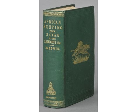
Lot 4
Baldwin (William Charles). African Hunting and Adventure from Natal to the Zambesi, Including Lake Ngami, the Kalahari Desert &c from 1852 to 1860, 2nd ed., 1863, portrait frontispiece, folding map, four tinted lithographed plates (one or two marginal repairs to verso), wood-engravings, 32 pp. catalogue at end, scattered light spotting, bookplate, original green cloth gilt, a trifle rubbed at spine ends, 8vo Czech p.16 (for the first edition). (1)
Lot 41
Hodges (William). Travels in India, during the years 1780, 1781, 1782, and 1783, 2nd edition, 1794, folding engraved map, fourteen engraved plates (complete), title torn with loss to lower outer corner, some spotting and light waterstaining, fore-edges with some browning and a few leaves with consequent short closed tears, contemporary calf backed marbled boards, rubbed and some wear, together with Robertson (William), An Historical Disposition concerning the knowledge which the Ancients had of India; and the progress of trade with that country prior to the discovery of the passage to it by the Cape of Good Hope, 1791, two folding engraved maps, a few minor marks, contemporary mottled full calf gilt, rubbed and some wear to extremities, with joints cracked, both 4to (2)
Lot 413
Guidott (Thomas). A Discourse of Bathe, and the Hot Waters There. Also, Some Enquiries into the nature of Water of St. Vincent's Rock, near Bristol; and that of Castle-Cary..., 1676, engraved frontispiece with explanation leaf facing, three engraved plates only (lacks map), one woodcut illustration (torn), near contemporary speckled & mottled calf, gilt decorated spine, joints cracked and upper board loose, 8vo, together with Allen (Benjamin), The Natural History of the Chalybeat and Purging Waters of England, with their particular Essays and Uses among which are treated at large the Apoplexy & Hypochondriacism, To which are added, some Observations on the Bath Waters in Somerset, 1699, bound without final four leaves (p.185, followed by "A Table of the Waters Examined" and "An Index of the Virtues and Properties of the Waters"), contemporary marginalia to E8 & F1 with some show through, some dampstaining, browning and spotting, hinges repaired, modern calf, morocco title label to spine, 8vo, plus two other incomplete related works (4)
Lot 42
Hohnel (Lieut. Ludwig von ). Discovery of Lakes Rudolf and Stefanie. A Narrative of Count Samuel Teleki's Exploring & Hunting Expedition in Eastern Equatorial Africa in 1887 & 1888, Translated by Nancy Bell (N. D'Anvers), 2 vols., 1st English ed., 1894, two large folding maps (reinforced to verso), single-page map frontispiece to volume II, illustrations, some spotting, bookplates (with residue opposite), original blue cloth gilt, spines rubbed with tears at ends, one or two small splits, a few stains, 8vo (2)
Lot 444
Philadelphia International Exhibition 1876. Official Catalogue of the British Section. Part I [& II], George E. Eyre and William Spottiswoode, 1876, 2 parts in one volume, 418 + 424 pages respectively, double-page chromolithograph frontispiece, showing the British Commission Staff Quarters, Fairmount Park, Philadelphia, folding geological map of Queensland, original gilt decorated green cloth, rubbed and some marks, minor fraying to extreme corners, large square 8vo Contains a history of exhibitions by Hugh Willoughby Sweny, and detailed descriptions of objects loaned to the exhibition by British manufacturers, including Appleby cranes, Elkington silverware, Minton tiles, Marcus Ward printing and stationery. The second part consists of an 'Exhibitors' Commercial Guide, containing, among other papers, the United States tariff of import duties upon articles of produce and manufacturers, in English currency; together with an epitomy of the American laws relating to patents and trade marks'. This copy contains a printed presentation slip from the Lord President of the Council to Viscount Gough, Downing Street, April 1877, loosely inserted. (1)
Lot 472
Golf. Golfer's Guide Vol. IV, Edinburgh & London, 1897, black and white plates from photographs (several more than listed), golf course map illustrations to text, commercial adverts (15 pages in total) at front and rear including endpapers, contemporary ownership inscription to upper margin of page ix 'Ludlow Golf Club from WHHG', some spotting, old water stain to lower margins of leaves at rear, inner hinges weak and contents shaken, lacks folding map of British Isles with golf courses marked in red, original red cloth gilt with pictorial design in black to upper cover and golf ball advert to rear board, spine faded and frayed, a little rubbed and marked, 8vo The directory entries include name, location, offices, number of members, year of founding and other information regarding the golf course. Very rare, with only one other copy located at Trinity College Library, Dublin. Donovan & Murdoch 1440: 'Fourth ed. not located'. (1)
Lot 490
Walker (George). The Battle of Waterloo. A Poem, 1st edition, G. Walker, 1815, 77pp., adverts to final leaf verso, title and final leaf chipped at edges with loss not affecting text, some browning and finger soiling throughout, lacks final advert leaf, modern marbled boards with manuscript paper label to spine, small 8vo (A rare copy of a poem written soon after the event, to commemorate the victory at the Battle of Waterloo, and preceded by a short description of the battle itself. WorldCat locates 7 copies, 3 in the UK and 4 in the USA), together with Houssaye (Henry), 1815 Waterloo, Translated... by Arthur Emile Mann and edited by A. Euan-Smith, A. & C. Black, 1900, extra-illustrated with 23 early 19th-century prints and engravings and one hand-coloured battlefield map, including a finely hand-coloured frontispiece of Napoleon plus folding print of Duke of Wellington, etc., top edge gilt, modern three-quarter brown morocco gilt by Bayntun, 8vo (2)
Lot 526
Baker (Samuel White). The Albert N'Yanza, Great Basin of the Nile and explorations of the Nile sources, volumes 1 & 2 bound in one, 1866, 37 illustrations and maps including frontispiece folding map, some light spotting and marks, contemporary green half calf, spine slightly faded and rubbed to head and foot, 8vo, together with Bovill (E.W.), Missions to the Niger, volumes 1-4 (complete), all 1st editions, The Hakluyt Society, 1964-66, numerous black and white illustrations and maps, volumes 3 & 4 ex-library with associated stamps, all original blue cloth in dust jackets, covers slightly spotted and marked, 8vo, plus Stanley (Henry M.), In Darkest Africa, volumes 1 & 2 (complete), 1890, 150 black and white illustrations and maps including frontispiece with tissue guards, some light spotting, original gilt-decorated red cloth, spines slightly rubbed to head and foot, 8vo, plus other 19th and 20th-century African historical and travel reference and related, all hardback publications, many original cloth in dust jackets, generally in good condition, 8vo (3 shelves)
Lot 529
MacDonald (George). The Roman Wall in Scotland, 1st edition, Glasgow, 1911, 55 black and white plates including frontispiece plus folding map to rear, bookplate to front pastedown, some light toning and spotting, original gilt-decorated blue cloth, spine slightly faded and rubbed to head and foot, 8vo, together with Humboldt (Alexander von), Letters of, 1860, some light spotting, contemporary decorated blue cloth, boards and spine slightly rubbed, 8vo, and Hamilton (Anthony), Memoirs of Count Grammont, limited edition 168/780 copies, 1889, black and white portrait frontispiece with tissue guard plus 33 black and white etchings, some light spotting, original gilt-decorated red cloth, boards and spine slightly marked and rubbed to head and foot, large 8vo, plus other 19th and early 20th-century historical and biographical reference and related, mostly hardback publications, some original cloth in dust jackets, G/VG, 8vo/4to (6 shelves)
Lot 53
Livingstone (David & Charles). Narrative of an Expedition to the Zambesi and its Tributaries; and of the Discovery of the Lakes Shirwa and Nyassa. 1858-1864, 1st ed., 1865, folding frontispiece, folding map, wood-engraved illustrations, publisher's catalogue at end, title and dedication leaves repaired at lower margin, scattered light spotting, original cloth gilt, rebacked with original spine relaid, some fading, 8vo, together with The Anglo-Egyptian Sudan: A Compendium Prepared by Officers of the Sudan Government, ed. Lieut.-Colonel Count Gleichen, 2 vols., 1905 (3)
Lot 533
Mollien (Gaspard). Travels in the Interior of Africa, to the Sources of the Senegal and Gambia; Performed by Command of the French Government, in the Year 1818, ed. T.E. Bowdich, 1st English ed., 1820, folding engraved map (small repair to verso), seven uncoloured aquatint plates, some light damp stains and toning, recent calf-backed boards, 4to, together with Younghusband (Captain Frank E.), The Heart of a Continent: A Narrative of Travels in Manchuria, across the Gobi Desert, through the Himalayas, the Pamirs, and Chitral, 1884-1894, 2nd edition, 1896, black and white plates and maps, folding map in rear pocket, blindstamp to title, slight spotting to endpapers, original publisher's cloth gilt, 8vo, plus Forbes (Henry O.), A Naturalist's Wanderings in the Eastern Archipelago, a narrative of travel and exploration from 1878 to 1883, 1st edition, 1885, numerous black and white illustrations plus colour frontispiece with tissue guard, 6 black and white folding maps, ex-library copy with associated stamps, some light spotting, new endpapers, original gilt-decorated cloth, boards and spine slightly rubbed, 8vo, plus other 19th and 20th-century travel reference and related including Baedeker Travel Guides, all hardback publications, some original cloth in dust jackets, G/VG, 8vo/4to (3 shelves)
Lot 549
Davis (John). The History of The Second Queen's Royal Regiment, now the Queen's (Royal West Surrey) Regiment, volumes 1-3 (complete), 1887, numerous black and white illustrations and map, ex-libris bookplates to front pastedowns, some loose pages, original gilt-decorated blue cloth, boards and spines worn to head and foot, 8vo, together with other late 19th and early 20th-century military and regimental history and reference, mostly hardback publications, G/VG, 8vo (6 shelves)
Lot 55
Ludolphus (Job). A New History of Ethiopia. Being a Full and Accurate Description of the Kingdom of Abessinia, Vulgarly, though Erroneously Called the Empire of Prester John, 1st ed., 1682, eight copper engraved plates (seven folding, lacking map?), Ethiopic alphabet leaf and folding genealogical table (table and one or two other plates cropped touching imprint or images, occasional small handling tear repaired), appears complete though erratic pagination pp.370-375, a few light spots and occasional small stain, title repaired, contemporary calf, rebacked and repaired, folio Wing L3468. (1)
Lot 553
Freshfield (Douglas W.). Italian Alps, Sketches in the Mountains of Ticino, Lombardy, The Trentino, and Venetia, 1st edition, 1875, 10 black and white wood-engravings and 5 black and white maps, contemporary inscription and book stamp to front endpaper, half-title portrait detached, some light spotting, original gilt-decorated green cloth, boards slightly marked, spine rubbed to head and foot, 8vo, together with Young (Geoffrey Winthrop), Mountain Craft, 3rd edition, 1934, 15 black and white illustrations including frontispiece, some minor spotting, original blue cloth in dust jacket, spine slightly faded and rubbed to head, 8vo, plus Dutton (E.A.T.), Kenya Mountain, 1st edition, 1929, 55 black and white illustrations including frontispiece, folding map to rear, minor spotting, original blue cloth, boards and spine slightly faded, 8vo, plus other late 19th and early 20th-century mountaineering and alpine reference and related, all original cloth, G/VG (3 shelves)
Lot 556
Fermor (Patrick Leigh). The Traveller's Tree, A Journey through the Caribbean Islands, 1st edition, 1950, numerous black and white illustrations and map, contemporary inscription to front endpaper, some loss to head of dust jacket, Mani, Travels in the Southern Peloponnese, 1958, ex-libris bookplate to front pastedown, both original cloth in dust jackets, covers slightly rubbed to head and foot, 8vo, together with Thesiger (Wilfred), Arabian Sands, 1st edition, 1959, 69 black and white plates including frontispiece, 9 black and white maps including one contained in rear pocket, original cream cloth in dust jacket, covers slightly rubbed, 8vo, plus Lewis (Norman), A Dragon Apparent, Travels in Indo-China, 1st edition, 1951, 27 illustrations including colour frontispiece, black and white folding map, original red cloth in dust jacket, spine slightly worn to head and foot, 8vo, and other 20th-century travel writing and reference including Freya Stark, Peter Fleming, Laurence Durrell, H.V. Morten, T.E. Lawrence, all hardback publications, many original cloth in dust jackets, G/VG, 8vo (6 shelves)
Lot 557
Grimble (Arthur). A Pattern of Islands, 1st edition, 1952, b & w illustrations and map, minor spotting, original decorated green cloth in dust jacket, covers slightly rubbed to head and foot with minor loss to head of front cover, 8vo, together with Huxley (Elspeth), Their Shining Eldorado, a journey through Australia, 1st edition, 1967, 20 black and white illustrations, 7 maps including folding map to rear, original blue cloth in price-clipped dust jacket, covers slightly rubbed with minor loss to head and foot, 8vo, and other modern Australian travel writing and historical reference, mostly hardback publications, many original cloth in dust jackets, G/VG, 8vo/folio (3 shelves)
Lot 565
Royal Commission Historical Monuments (Publisher). An Inventory of the Historical Monuments in the City of Cambridge, parts 1 & 2 plus maps, 1st editions, Royal Commission on Historical Monuments, 1959, numerous black and white illustrations and maps, original gilt-decorated cloth in dust jackets, covers slightly toned and marked, spines slightly rubbed to head and foot, large 4to, (3 volumes in total), together with Dearn (T.D.W.), An Historical Topographical and Descriptive Account of the Weald of Kent, 1814, black and white map, lacks 8 sepia engravings, slightly spotted, contemporary inscription to bookplate to front endpaper, contemporary boards, boards rubbed, hinges and spine cracked with loss, 8vo, and Kingsley (David), Printed Maps of Sussex 1575-1900, Sussex Record Society volume 72, 1982, black and white illustrations, original brown cloth in dust jacket, 4to, plus other 19th and 20th-century British topographical reference, including publications by Sutton, David & Charles, Philimore, Breedon Books, mostly original cloth in dust jackets, G/VG, 8vo/folio (6 shelves)
Lot 60
Mitchell (Lieutenant Colonel Sir T.L.). Journal of an Expedition into the Interior of Tropical Australia, in Search of a Route from Sidney to the Gulf of Carpentaria, 1st ed., 1848, eleven tinted lithographed plates (one trimmed with frayed foredge), seven maps (one folding map repaired and laid down), wood-engraved plate, some light soiling and waterstains, later half calf, a little rubbed, 8vo, (Ferguson 4828), together with Mudie (James). The Felonry of New South Wales: Being a Faithful Picture of the Real Romance of Life in Botany Bay, 1st edition, 1837, folding lithographed plan (sellotape reinforcement of folds to verso), light spotting, previous owner signature to title, bookplate, later morocco-backed boards, a little rubbed, 8vo, plus A Statistical, Historical, and Political Description of the Colony of New South Wales, and its Dependent Settlements in Van Diemen's Land: With a Particular Enumeration of the Advantages which these Colonies offer for Emigration, and their Superiority in many Respects over those Possessed by the United States of America, by W.C. Wentworth, 1st edition, 1819, extra folding engraved plate of the Inhabitants of New Caledonia, 1784 bound-in, title soiled with crude repairs to verso and following leaf, scattered spotting, front hinge breaking, contemporary boards, rubbed with cracks to spine, 8vo, and Stoney (H. Butler, Captain). A Residence in Tasmania: with a Descriptive Tour through the Island, from Macquarie Harbour to Circular Head, 1st UK edition, 1856, double-page map, 8 tinted lithographed plates, 16 pp. publisher's catalogue at end, frontispiece repaired and detached, previous owner signature to title, all edges stained red, later mottled calf, rebacked, spine gilt with red and green labels, 8vo, (Ferguson 16295), plus other 19th century Australian travel, including Wentworth, A Statistical, Historical, and Political Description of the Colony of New South Wales, 1820, John West, The History of Tasmania, 2 volumes, Tasmania, 1852, Sir William Denison, Varieties of Vice-Regal Life, 2 volumes, 1870, & a defective copy of Philipps's Voyage to New South Wales, 1789, all 8vo (10)
Lot 61
Mitra (Rajendralala). The Antiquities of Orissa, volume one (of two) only, Calcutta: Wyman & Co., 1875, lithographed map frontispiece, thirty-five lithographed plates, few black and white illustrations to text, light scattered spotting, original publisher's cloth gilt, a little rubbed and scuffed with loss to foot of spine, folio (1)
Lot 63
Nansen (Fridtjof). Farthest North. Being a Record of a Voyage of Exploration of the Ship Fram 1893-96 and of a Fifteen Months' Sleigh Journey by Dr. Nansen and Lieut. Johansen, with an Appendix by Otto Sverdrup, Captain of the Fram, 2 vols., 1st ed., 1898, folding map, black & white plates and illustrations, original pictorial cloth blocked in gold and silver, in bright condition, edges a trifle rubbed, 8vo, together with Scott (Robert Falcon), Scott's Last Expedition, 4th edition, 2 vols., 1914, colour and black & white plates, folding maps, occasional spotting, top edge gilt, remainder untrimmed, original cloth gilt, damp mottling to lower outer corners of boards, large 8vo, with Cherry-Garrard (Apsley), The Worst Journey in the World, Antarctic 1910-1913, reprinted, 1939, original cloth in d.j., 8vo, plus other polar exploration related (17)

Lot 646
*Embroidered Map. Europe, published by Laurie & Whittle, Jan, 1797, printed map on silk, outline and text embroidered by hand in coloured silks, 44 x 38cm (17 x 15ins), framed and glazed, together with a similar embroidered map showing Scotland and two embroidered ovals of pastoral scenes (4)
Lot 65
Nieuhof (Johannes). Die Gesantschaft der Ost-Indischen Geselschaft in den Vereinigten Niederl„ndern, an den Tartarischen Cham und nunmehr auch Sinischenkeyser, edited by Peter de Gojern and Jacob Keisern, first German edition, Amsterdam: Jacob van Meurs, 1669, title in red and black twenty-nine (of 34) double-page or folding plates, one-hundred and six engraved illustrations to text, lacking additional engraved title and portrait of the author, folding engraved map torn with substantial loss, some short closed handling tears to margins (rarely affecting text, few repaired), few plates with repaired tears, illustration on p.72 pasted over another (as usual), some scattered dust-soiling and few minor marks, endpapers renewed, contemporary vellum , repaired, soiled and a little marked, folio (1)
Lot 68
Priestley (Raymond E.). Antarctic Adventure, Scott's Northern Party, 1st edition, 1914, folding map and black and white plates, original cloth gilt, spine faded, slightly rubbed, split at head of spine and some markings and wear to upper and lower covers, together with Osborn (Sherard), The Discovery of the North-West Passage by HMS Investigator... , 3rd edition, 1859, portrait frontispiece, folding map (linen backed), 4 lithographed plates, some soiling, marginal repair to 1 plate not affecting image, circulating library label to front pastedown and upper cover, original cloth gilt, a little wear at head and foot of spine, plus Richardson (John), Arctic Searching Expedition: A Journal of a Boat-Voyage Through Rupert's Land and the Arctic Sea, In Search of the Discovery Ships Under the Command of Sir John Franklin, 2 volumes, 1st edition, 1851, 10 hand-coloured lithographed plates, woodcuts and diagrams to text, folding coloured map, some heavy spotting and offsetting, ownership name excised from top corner of both title-pages not affecting text, original cloth, some soiling and wear, spines strengthened, all 8vo, plus others related (13)
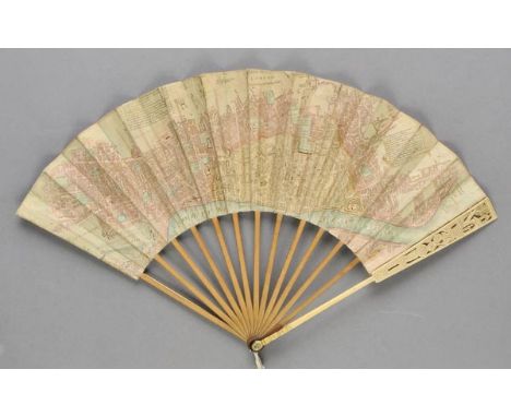
Lot 688
*Map fan. A New and Correct Plan of London, including all ye New Buildings &c., n.p., circa 1760, folding paper fan, the hand-coloured leaf engraved by Richard Bennett with a plan of London, and insets showing the Rates of Hackney Coaches, toned and with splits to a number of folds (old paper and vellum repairs on verso and evidence of earlier stitching), mounted on wooden sticks, with ivory guard sticks carved with chinoiserie decoration (lower guard stick with old 2" repair just above pivot), 30cm (12ins) Rare. Not in the Schreiber Collection. (1)

Lot 689
*Map fan. Plan of Bath from an Actual Survey with the Improvements to the present Year 1793, [Cock and Crowder, Jany 1st, 1793], folding paper fan, the leaf with a map of Bath, a detail of Lansdown Place, two circular views after Malton, and gazetteer including inns etc., later impression(?) with imprint obliterated by thick printed line, spotted, split at some fold edges and with slight loss to lower edge of leaf, mounted on wooden sticks, 25.5cm (10ins), contained in a cardboard fan box (defective) Scarce. Not in the Schreiber Collection. (1)
Lot 69
Roberts (Robert). Diary of a Voyage to Australia, New Zealand and other Lands, Covering the Twelve Months Lying Between 21st August, 1895, and 19th August, 1896, 1st edition, Birmingham, 1896, [4], 202 pp, title-page and text-block edges dust-soiled, modern plain wrappers with manuscript title, remains of original wrappers retained, the upper pictorial wrapper (with ownership signature of V.W. Reynolds) partly chipped, trimmed and laid down, the lower wrapper chipped at corners and somewhat dust-soiled, 8vo, together with Mines and Minerals. Annual Report of the Department of Mines, New South Wales, for the Year 1879, 2 volumes, text/maps, Sydney, 1880, folding maps and plates, a little light spotting, original wrapper and cloth-backed boards, inkstamps and light soiling, 4to, plus New South Wales in 1881: Being a Brief Statistical and Descriptive Account of the Colony up to the End of the Year Extracted from Official Records, Thomas Richards, 2nd issue, Sydney, 1882, folding colour map, folding tables, inkstamp at foot of title, original wrappers, a few chips and tears, 8vo, and three others including two Imperial Institute monographs: Coal, by J.H. Ronaldson, 1920 and Petroleum, 1921, and House of Commons Acts and Reports. A group of printed government reports and acts relating to Australia, circa 1834-77, including Copies or Extracts of any Correspondence Between the Secretary of State and the Governor of Van Diemen's Land on the Subject of Convict Discipline, HMSO, 1845; Report from Select Committee on the Colonial Military Expenditure: With the Minutes of Evidence, Appendix, and Index, Ordered to be Printed 7 August 1834; Report from the Select Committee on Colonial Military Expenditure; together with Minutes of Evidence, and Appendix and Index, 4 August 1835; Report from the Select Committee on the Accounts of Colonial Receipt and Expenditures, with the Minutes of Evidence, Appendix and Index, 13 July 1837; Thirteenth Report of the Board for the Protection of the Aborigines in the Colony of Victoria, [1877], plus one further report, a printed letter (Islanders of the Pacific) and a bill concerning convict prisons (1859), plus 27 extracted Acts of Parliament relating to Australia with no duplicates (George III x 1, George IV x 12 and Queen Victoria x 27), all disbound, folio (a carton)
Lot 70
S.D.U.K. Maps of The Society for the Diffusion of Useful Knowledge, 2 volumes, published Chapman & Hall, 1844, 161 engraved maps, including some folding and double page, the map of Africa with later ink manuscript annotations one comparison plate of the rivers of the world, forty-seven town plans and six celestial star charts, complete as lists, occasional marginal fraying, very slight spotting, a.e.g., contemporary half morocco gilt, folio (2)
Lot 71
Savory (Isabel). A Sportswoman in India, 1st ed., 1900, portrait frontispiece, black and white illustrations, a couple of leaves at front with marginal repairs (rough opening), scattered spotting, top edge gilt, original red cloth gilt, spine ends a little rubbed, 8vo, together with Forty (Lieut.-Col. C.H.), Bangkok: Its Life and Sport. With some Account of Siam's Coastal and Island Game Areas, 1st ed., 1929, half-tone illustrations, publisher's list at end, light spotting, original orange cloth, spine a little faded, 8vo, plus Millett (Marcus W.), Jungle Sport in Ceylon. From Elephant to Snipe, 1st ed., 1914, map and illustrations, publisher's catalogue at end, some light spotting, original green cloth, slight fading to spine, 8vo, with five others including A.E. Leatham's Sport in Five Continents, 1912, Theodore & Kermit Roosevelt's Trailing the Giant Panda, 1929 and Claude H.B. Grant's The Shikari. A Hunter's Guide, 1914 (8)
Lot 72
Selous (Frederick Courteney). Sport and Travel East and West, 1st ed., 1900, half-tone illustrations, publisher's catalogue at end, a few minor spots, original green cloth gilt, 8vo, together with A Hunter's Wanderings in Africa, Being a Narrative of Nine Years Spent Amongst the Game of the Far Interior of South Africa, 4th ed., 1895, folding map, plates and illustrations, blindstamp to half title, bookplate and ownership inscription at front, original green cloth gilt, one or two light marks, 8vo (2)

Lot 730
Grahame (Kenneth). The Wind in the Willows, 1st illustrated edition, 1931, illustrations by E.H. Shepard, folding map, edges untrimmed, original cloth-backed boards (slight soiling and edgewear, spine label worn with slight loss), 4to Limited edition, 127/200, signed by Kenneth Grahame and Ernest H. Shepard. (1)
Lot 74
Storey (Harry). Hunting & Shooting in Ceylon, 1st ed., 1907, portrait frontispiece, folding map at end (repairs to verso), half-tone illustrations, scattered spotting, presentation inscription from Frank Storey to front endpaper, original blue cloth gilt, spine ends a trifle rubbed, 8vo, together with Pitman (Captain C.R.S.), A Game Warden Among his Charges, 1st ed., 1931, folding map, illustrations, light spotting, previous owner signature, original cloth, faded with some spotting, 8vo, plus Major P.M. Stewart's Round the World with Rod and Rifle, 1st ed., 1924, inscribed by the author (3)
Lot 77
Thunberg (Charles Peter). Travels in Europe, Africa, and Asia, Performed Between the Years 1770 and 1779, 4 vols., 3rd ed., [1795]-96, half titles for vols. I-III, eleven engraved plates (a couple close-trimmed at lower margin, some light spotting, waterstains, bookplates and previous owner signatures, contemporary calf, vols. II-IV rebacked with original spines relaid, vol. I upper joint split, a little rubbed with mottled dampstains and small shelf numbers taped to covers, 8vo, together with Spenser St. John's Life in the Forests of the Far East; Or Travels in Northern Borneo, 2 vols, 2nd revised edition, 1863 (lacking vol. 2 map) First work: Cox I, 343: "These travels relating to Japan are exceedingly valuable with respect to the natural history." (6)
Lot 772
Rackham (Arthur, illustrator). The Chimes, by Charles Dickens, Introduction by Edward Wagenknecht, printed in London by George W. Jones for the members of The Limited Editions Club, 1931, twenty black & white letterpress illustrations, six full-page, pictorial endpapers, bookplate of Jonas Bikoff on verso of front free endpaper, top edges gilt, original bevel-edged tan cloth, spine darkened, in original card slipcase, somewhat worn and soiled, small folio, (limited edition, 45/1500 copies, signed by Arthur Rackham. Riall, p.173), together with Peter Pan in Kensington Gardens, by J.M. Barrie, Hodder & Stoughton, circa 1920s, sixteen tipped-in colour plates, with captioned tissue guards, map front endpapers, original gilt and blindstamped red cloth, spine slightly faded, small 4to, plus two others illustrated by Rackham (Some British Ballads, [1919], original cloth, and a rebound copy of Undine, new impression, June 1919), plus Quality Street and She Stoops to Conquer, illustrated by Hugh Thomson, both volumes in original cloth (spines faded, latter with nick at head), plus Wild Pilgrimage, by Lynd Ward, 1932, original cloth, 4to (7)
Lot 78
Townsend (Joseph). A Journey through Spain in the Years 1786 and 1787, with Particular Attention to the Agriculture, Manufactures, Commerce, Population, Taxes, and Revenue of that Country; and Remarks in Passing through a Part of France, engraved map frontispiece to vol. 1, seven engraved plates, some dampstaining and few marks, slight wear to volume 3 fore-edges, endpapers renewed, contemporary marbled boards with recent calf spines, 8vo (3)
Lot 81
Walsh (Thomas). Journal of the Late Campaign in Egypt. Including Descriptions of that Country, and of Gibraltar, Minorca, Malta, Marmorice, and Macri; with an Appendix..., 2nd edition, 1803, folding engraved map frontispiece, fifty engraved maps and plans on forty sheets (including some folding, some with hand colouring), list of subscribers, some damp staining, spotting and dust-soiling, edges untrimmed, original boards, rebacked, rubbed and worn, spine deficient, upper board detached, 4to, together with Watt (W. Montgomery), Muhammad at Mecca, Oxford: Clarendon Press, 1953, half-title, endpapers toned, original publisher's cloth, 8vo, plus Seabrook (W. B.), Adventures in Arabia, Among the Beduins Druses Whirling Dervishes and Yezidee Devil-worshippers, George Harrap & Co., 1928, half-title, black and white frontispiece, numerous black and white plates and illustrations to text, some scattered spotting, original decorative cloth, a little rubbed and lightly scuffed, 8vo, plus other travel books, relating to Egypt and Arabia, including some in Arabic (15)
Lot 83
Bell (James). A New and Comprehensive Gazetteer of England and Wales, 8 vols., Glasgow, 1838, folding coloured map of England and Wales, 44 folding engraved county maps, many with topographical vignettes, manuscript list at front of first volume, some light spotting and offsetting, small previous owner inkstamps to front pastedowns, original cloth, brown labels to spines, a little rubbed and faded, 8vo (1)
Lot 84
Brettingham (Matthew). The Plans, Elevations and Sections, of Holkham in Norfolk, the Seat of the Late Earl of Leicester, 1st ed., 1761, 23 sepia-engraved plates and plans only (of 28), lacking dedication and preface leaves, folding plate with small marginal loss and reinforcements, some scattered spotting, near contemporary half sheep, rubbed, folio, (Harris 46. Provenance: The Earl of Leicester, presentation inscription (and later inscription) to title),together with Ainsworth (William), Researches in Assyria, Babylonia, and Chaldaea; Forming Part of the Labours of the Euphrates Expedition, 1st ed., 1838, tinted lithographed frontispiece (with blindstamp), title with wood-engraved vignette, folding map, three hand-coloured folding geological sections at end, publisher's catalogue, scattered light spotting, endpapers renewed, original green blindstamped cloth, spine darkened and re-adhered with old shelf numbers, small splits and chips, 8vo, plus Macdonald (Capt. R.J.), The History of the Dress of the Royal Regiment of Artillery, 1625-1897, Sotheran, 1899,25 colour plates, scattered light spotting, original cloth-backed boards, edges a little rubbed, a few light marks, 4to Limited edition, 67/300 signed by the author. (3)
Lot 87
Cary (John). Cary's Survey of the High Roads from London to Hampton Court, Ware, Bagshot..., Richmond, On a Scale of one Inch to a Mile; wherein Every Gentleman's Seat, situate on, or seen from the Road, (however distant) are laid down, with the name of the Possessor; to which is added, the Number of Inns on each separte Route; also, The different Turnpike Gates shewing the Connection which one trust has with another, 1st edition, 1st July, 1790, title page and table of explanation, folding engraved general map of the environs of London showing the turnpike roads with sparse contemporary outline colouring, another map showing the turnpike gates with contemporary wash colour and eighty double page engraved strip road maps (complete) on forty sheets, all with contemporary hand colouring, some staining throughout, contemporary sheep 'envelope style' binding, worn and frayed, 8vo (1)
Lot 89
Cooke (William). A New Picture of the Isle of Wight, Illustrated..., to which is prefixed, an Introductory Account of the Island, and a Voyage Round its Coast, 1808, Extra Illustrated containing engraved frontispiece and fifty-four engraved & uncoloured aquatint plates (36 plates called for), hand-coloured engraved map, plus five others loosely inserted, occasional spotting, contemporary calf gilt, upper joint and spine torn at head, rubbed, 4to, together with Britton (J., & Brayley, E.W.), Devonshire & Cornwall Illustrated, from the Original Drawings by Thomas Allom, WH. Bartlett..., with Historical and Topographical Descriptions, 1832, two engraved maps and two engraved titles, 138 engraved views on 69 plates, some spotting, all edges gilt, contemporary half morocco, covers detached and spine torn with loss, worn, 4to, plus two other Isle of Wight related (4)

Lot 91
Coxe (William). An Historical Tour in Monmouthshire; Illustrated with Views by Sir R. C. Hoare, Bart. A New Map of the County, and Other Engravings, 2 vols., 1st ed., Printed for T. Cadell, Jun. and W. Davies, 1801, half-titles present, Extra Illustrated containing a total of 221 plates, plans & maps, mostly 18th/19th century (some window mounted), comprising 10 maps (3 folding) including the Countye of Monmouth by John Speed [1627], County of Monmouth by Robert Morden [1695] and Monmouthshire by N. Coltman, one pencil drawing, 17 double-page & two folding plates & plans, numerous engraved illustrations to text, occasional spotting, top edge gilt, cloth hinge repairs, later 19th century panelled calf, gilt decoration, contrasting morocco labels to spines, neatly rebacked, 4to Upcott, pp.933-939. (2)
Lot 914
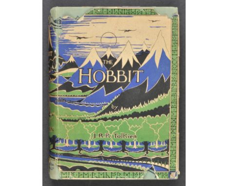
Tolkien (J.R.R.). The Hobbit or There and Back Again, 1st ed., 2nd impression, 1937, four colour plates by the author, black and white illustrations, advertisement leaf at end, map endpapers, neat presentation inscription to front endpaper, original green pictorial cloth, small lightly faded patch at foot of spine, d.j., vertical split along upper joint (just attaching), some chips and losses, spine and flaps a little toned, 8vo The second impression, published in the same year as the first and is the first edition with the colour plates. (1)
Lot 918
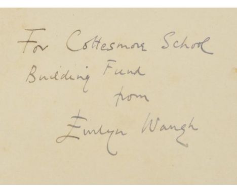
Waugh (Evelyn). When the Going Was Good, 1st ed., 1946, colour frontispiece, folding map, light spotting front and rear, original yellow cloth, price-clipped d.j. (spine ends and folds strengthened with white tape to verso), 8vo Presentation copy, inscribed to front endpaper: "For Cottesmore School Building Fund, from Evelyn Waugh". (1)
Lot 919
Waugh (Evelyn). Labels. A Mediterranean Journal, 1st ed., 1930, half-tone illustrations, one or two spots, original cloth, spine faded, d.j. tears and losses, mainly to spine, 8vo, together with When the Going Was Good, 1st ed., 1946, colour frontispiece, folding map, original yellow cloth, d.j., a few chips and tears to spine and front panel, 8vo, plus A Tourist in Africa, 1st ed., 1960, illustrations, original cloth, d.j., spine and rear panel a little toned, 8vo, with three others: Remote People, 1931, Waugh in Abyssinia, 1936, and Wine in Peace and War [1947], all lacking d.j.s (6)
Lot 925
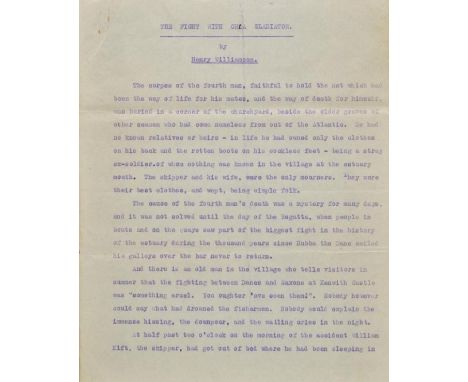
*Williamson (Henry, 1895-1977 ). The Fight with Orca Gladiator, unpublished typescript short story, circa 1930s, 18 leaves of single-sided cyclostyled typewritten text, tear with some text loss to left margin of page 4, final leaf chipped and frayed without loss of text but with some toning and lightening of two lines of text, two small manuscript corrections (? by Williamson) to last page, 4to, together with On Foot in Devon or Guidance and Gossip, Being a Monologue in Two Reels, 1st edition, 1933, 8 photographic plates, map endpapers, author's signed presentation inscription to front free endpaper, inscribed for Betty Radford and dated at Lydford, 18 September 1933, written on cloth in dust jacket, spine browned and split at foot of upper joint, 8vo The climax of this short story concerns a dramatic sea battle between a killer whale and four sea lions named Princess, Berserk, Daggoo and Ra. (2)
Lot 95
Moule (Thomas). The English Counties Delineated; or a Topographical Description of England..., 2 volumes, published George Virtue, 1837, additional decorative title, portrait frontispiece of William IV, folding decorative engraved map of England & Wales, trimmed with slight loss, four sheet map of England & Wales, a 'comparison' plate, one engraved plate of Canterbury Cathedral and forty-nine decorative engraved maps, several trimmed with slight loss, slight spotting throughout, near contemporary half calf, re-backed but retaining original spines, marbled sidings a little rubbed, 4to, together with, Aikin (John), England Delineated; or a Geographical Description of every County in England and Wales..., 3rd edition, 1795, folding engraved map of England & Wales and forty-two uncoloured engraved county maps, occasional pencil annotations to text, some staining to rear of atlas affecting maps and text, modern half calf gilt, 8vo (3)
Lot 97
Pennant (Thomas). A Journey from London to the Isle of Wight, 2 vols. in one, 1801, hand-coloured engraved folding map frontispiece to each volume, 47 engraved plates (of 48, lacking plate of St. Augustin's Monastery, one plate folding), occasional minor spotting, dampstain to fore-edge margins, together with Some Account of London, 4th edition, 1805, additional engraved title, 15 engraved plates including 3 folding (of 16), one plate repaired to fore-edge margin, some dampstaining, offsetting & spotting, plus A Tour from Downing to Alston-Moor, 1801, half-title, 27 engraved plates, bound with A Tour from Alston-Moor to Harrowgate, and Brimham Crags, 1804, 9 engraved plates, some dampstaining mostly to margins, uniform contemporary tree calf, each volume neatly rebacked, Alston Moor volume with some staining at foot of boards, 4to Provenance: From the library of Frederick Morrell, Black Hall, St. Giles, Oxford, with his bookplate. (3)
Lot 98
Prout (John Skinner). The Castles and Abbeys of Monmouthshire, 1838, tinted lithograph title, lithograph dedication and 29 tinted lithograph plates, spotting throughout (particularly to title), contemporary red half morocco gilt, spine and extremities rubbed, damp mottling to lower board, large folio, (56.7 x 38cm), together with a folding engraved map of Gloucestershire by Saxton Kip [c.1637] with relevant text leaves from Camden's Britannia, repair to central fold with slight loss, few closed tears and fraying, engraved map of Monmouthshire by Pigot & Co. (hand-coloured in outline) Abbey Scenery 538. (1)
Lot 101
Skelton (Joseph). Engraved Illustrations of the Principal Antiquities of Oxfordshire from Original Drawings by F.Mackenzie, published J.Skelton, 1823, decorative calligraphic title, uncoloured engraved map, fifty uncoloured engraved plates, numerous engraved chapter headings, some spotting throughout, near contemporary half morocco gilt, rubbed and worn at extremities, large 4to, together with, Westall (William), Great Britain Illustrated, A Series of Original Views, published Charles Tilt, 1830, additional decorative title, 118 uncoloured engraved views on fifty-nine sheets, some spotting throughout, contemporary gilt decorated calf, upper board detached, worn and frayed, 4to, with, Allom (Thomas, Noble T. & Rose T.), The Counties of Chester, Derby, Leicester, Lincoln and Rutland, published Fisher Son & Co., circa 1850, additional decorative title with contemporary dated ownership signature, seventy-two engraved plates on thirty-six sheets, slight spotting, a.e.g., publisher's cloth gilt, spine near detached and partially lacking, worn and frayed, 4to, plus, Jaffray (James), Graphic Illustrations of Warwickshire, published Birmingham, 1862, thirty-two uncoloured engraved plates, very slight spotting, a.e.g., contemporary half morocco gilt, worn at extremities, 4to, and Dugdale (William), Curiosities of Great Britain. England & Wales Delineated..., 3 volumes, published J.Tallis, circa 1845, decorative title, engraved frontispiece to each volume, a few of the front leaves detached, 225 engraved topographical views, eighteen portraits and fifty-eight double page engraved maps, some offsetting to maps, slight spotting thoughout, hinges and joints weak, contemporary marbled calf, gilt decorated spines, spine on volume two split, spines faded, worn, 8vo (7)
Lot 107
Abbot (Charles). Flora Bedfordiensis, Comprehending such Plants as Grow Wild in the County of Bedford, According to the System of Linnaeus with Occasional Remarks..., published Bedford by W.Smith, 1798, title page with author's manuscript presentation inscription, six uncoloured engraved plates, indexes bound at rear, ownership signature to front endpaper, 19th-century half calf gilt, a little bumped, 8vo, together with Druce (George Claridge), The Flora of Berkshire... , Oxford, 1897, later inscription to front endpaper, The Flora of Buckinghamshire... , 1926, black and white frontispiece, both original cloth, boards slightly marked, spines lightly rubbed to head and foot, 8vo, (2 volumes in total), plus Mansel-Pleydell (John Clavell), The Flora of Dorsetshire..., 2nd edition, 1895, 1 colour folding map frontispiece, 1 colour folding map to p. 1, 1 extra colour folding map disbound to rear, some light spotting, contemporary inscription to front endpaper, original gilt-decorated red cloth, boards and spine slightly marked, 8vo, and Jones (J.P. & Kingston, J.F.), Flora Devoniensis..., 1829, contemporary inscription to half-title, worming to top right corners from front pastedown to p. 16 of 'Part II. Arrangement of The Plants According to the Natural Method', some light spotting, contemporary half calf boards and spine rubbed, hinges cracked, 8vo, plus other county flora reference, generally in good condition, 8vo/4to (approx. 70)
Lot 12
Burton (Richard F.). The Lake Regions of Central Africa. A Picture of Exploration, 2 vols., 1st ed., 1860, twelve chromoxylographed plates, folding map, wood-engraved illustrations, advertisement leaf at end of volume 2, a few minor spots, bookplate and previous owner inscription to front pastedowns, original violet blindstamped cloth, rebacked with original spines relaid (faded), 8vo Penzer pp. 65-66. A classic work on East Africa, in which Burton describes his journey from Pemba and Zanzibar to the western shore of Lake Tanganyika. Amongst his party was John Hanning Speke who Burton attempts to discredit from the outset, by stating in the Preface that he was no more than a subordinate. (2)
Lot 122
Holt (John). General View of the Agriculture in the County of Lancaster: with Observations on the means of its Improvement. Drawn up for the Consideration of the Board of Agriculture and Internal Improvement from the Communications of Mr John Holt of Walton, near Liverpool; and the additional Remarks of several respectable Gentlemen and Farmers in the County, 1795, folding engraved county map, five engraved plates (one folding), two folding tables, and few wood engraved illustrations, bookplate of North of Thurland Castle, contemporary half calf, lower board detached and upper board loose & near detached, spine and extremities worn, 8vo, together with The Commercial and Agricultural Magazine, vols. 1-10, pub. 1799-1804, few engraved plates and maps (some folding), volume 1 title with short tear & printing fault to imprint, contemporary half calf, lacking title labels, worn with some leather lifting, marbled sidings torn with loss and some lifting or lacking, 8vo Sold with all faults, not subject to return. (11)
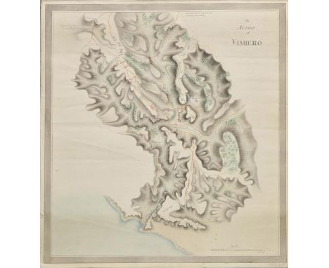
Lot 152
Battle plans. Smith (Malcolm), The Action of Vimiero, circa 1808, pen and watercolour manuscript battle plan of the battle of Vimeiro, occasional marginal closed tears, 540 x 510 mm The battle of Vimeiro was a resounding victory for General Arthur Wellesley (later the Duke of Wellington) against the French during the Peninsular war; fought in Portugal near Lisbon. Its significance was that it effectively ended the first French invasion of Portugal. Captain Malcolm Smith of the 83rd (County of Dublin) regiment whose signature appears lower right, appears to be the author of the map but it is an historical observation as his regiment did not arrive in Portugal until April 1809, some seven months after the battle. (1)
Lot 153
Bedfordshire. Speed (John), Bedford Shire and the Situation of Bedford described with the Armes of thos Honorable Familyes that have borne ye titles of Dukes and Earls thereof, published Roger Rea, [1662], uncoloured engraved map, inset plan of Bedford, small library blindstamp to margin, slight staining largely confined to margin, 380 x 510 mm, English text on verso (1)
![Berkshire. Speed (John), Barkshire Described, published Roger Rea, [1662], uncoloured engraved map, large engraved panorama o](https://cdn.globalauctionplatform.com/e6986aac-6ee6-4136-8dcf-a56700bd94e2/a4b737ca-6848-4e5c-dd25-00ff176b6397/468x382.jpg)

Lot 155
Bohemia. Speed (John), Bohemia Newly Described, published George Humble, circa 1627, uncoloured engraved 'carte a figures' map, ten costumed figures to vertical margins and seven oval vignettes along upper horizontal margins, lower margin trimmed to neatline with slight fraying, 410 x 525 mm, English text on verso (1)
-
109198 item(s)/page