We found 109182 price guide item(s) matching your search
There are 109182 lots that match your search criteria. Subscribe now to get instant access to the full price guide service.
Click here to subscribe- List
- Grid
-
109182 item(s)/page


Lot 493
Benjamin Rees Davies (19th Century) - Engraving - "Davies's Map of the Environs of London", folding map of London and surrounding counties, thirty-six sheets laid onto cloth, published by Edward Stamford, 6 Charing Cross, London 1868 and sold by Letts Son & Co., 8 Royal Exchange, 29ins x 41.5ins, within case, and Benjamin Baker (1766-1841) - Engraving - Folding map of East Kent, twenty-four sheets laid onto cloth, published 1st of January 1819 by Col. Mudge and sold by Letts Son & Co., 8 Royal Exchange, 37ins x 24.5ins, contained in blue slip case

Lot 361
John Ogilby (1600-1676), a copper engraving of 'The Road from Oxford to Coventry continued to Derby' strip map, circa 1675, later hand coloured, the back stating that the piece was authenticated by the British Library in 1987 although this is unproven, framed, 35 cm x 45 cm, together with a watercolour of the Doge's palace Venice, unsigned, framed and glazed, 18 cm x 32 cm (2)
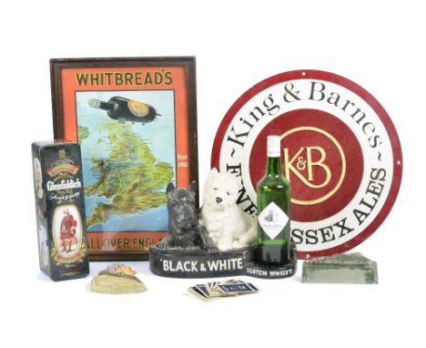
Lot 80
A selection of 20th Century alcohol related memorabilia, including a 1950s Whitbread's advertising poster, featuring a bottle of wine flying over a map of the UK titled 'All Over England', framed, height 45 cm, a reproduction King & Barnes circular enamel advertising sign, diameter 46 cm, a bottle and figurine of Black & White Scotch Whiskey and more (parcel)


Lot 546
THREE SUSAN HOWELLS (BRITISH 1948) limited edition prints, mounted, framed and glazed, approximate size 7cm x 7cm, together with a large coastal landscape, indistinctly signed, framed, approximate size 61cm x 122cm, modern abstract on canvas, unsigned, 1805 map of Gloucester, engraving print of Chale Church and aluminium map of Great britain


Lot 791
A BOX OF BOOKS, to include Blackie, W.G 'The Comprehensive Atlas & Geography of The World, comprising an extensive series of maps...., 1st Edition, 1882, Keltie, J. Scott, 'The World-Wide Atlas of Modern Geography', 7th Edition, Johnston, 1906 and The Map Collectors Circle Magazine, four bound volumes, (1960's), plus many other individual issues (1963-1975)


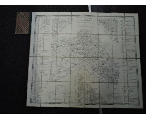
Lot 1020
Map. Kashmir Route Map - Compiled by Capt. T. G. Montgomerie, Engineers, F. R. G. S. Fifth edition, 1867. Comprising 32 folding sections. Cloth backed. Measures: 68.5cm x 79.5cm. Bound in a contemporary green cloth, spine worn. Marbled end papers bearing stamp for 'National Army Museum'. Uncommon.
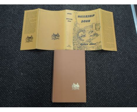
Lot 1032
Modern Fiction. Adams, Richard - Watership Down. London: Rex Collings, 1972. First Edition. Publisher's cloth, in dust wrapper. Price of '£3.50 net' on dust wrapper. Folding map at rear. Corners of wrapper spine having tape repairs on reverse. VG copy.Condition Report - No names inscriptions or bookplates, light spotting to front end papersno ripped or loose pagesspotting to the end paperslight rubbing to tail of the spine.Map in good condition


Lot 1092
Antiquarian Map. 'Noord-Holland': Le Comté de Hollande / dressé sur les memoires les plus nouveaux par le Sr. Sanson, geographe ordinaire du roy ; presenté à ... le Dauphin ... par ... Alexis Hubert Jaillot. Dated 1696, likely a mid-18th century copy published in Amsterdam. Later colouring.

Lot 2310
Set of parts for an original vintage travel poster advertising trips from Southampton in the UK to Le Havre in France issued by French Railways. Great design shows the Route from London to Paris on a map with images of a ferry and a sleeping cabin. Stylised text above reads - Partez et Dormez - An English translation of this is included on another separate sheet reading - Travel While Sleeping. Text on a separate sheet reads - You follow the quotation in liner at stopovers of Brest and Lorient you excursion by bus and you sleep at the hotel / Vous suivez la cote en paquebot au escales de Brest et de Lorient vous excursionnez en autocar et vous couchez a l'hotel. Blue border with text. Poor condition, main poster is missing part at the middle, there are 5 part in total, two pars from the top of the same poster in English and once part from a different poster. Bottom creases, folds, tears, paper losses. Country: France, year of printing: 1930s, designer: Unknown, size (cm): 78x61.5cm/ 61x9.5cm/ 61.5x9cm/61.5x11cm/61.5x15cm
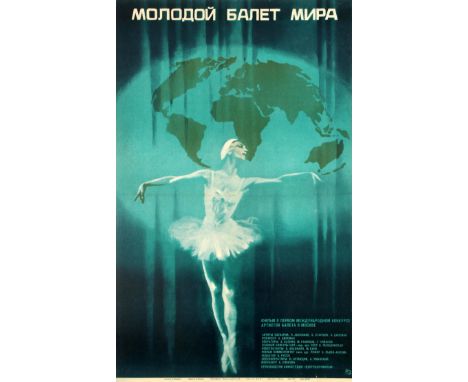
Lot 5718
Original vintage Soviet film poster for a feature on the first International Ballet Competition for young ballet dancers held in Moscow - showing a ballerina (possibly the prima ballerina Ludmila Semenyaka b. 1952) in an elegant pose in front of a world map shaded like a theatre curtain with the title above and the credits below. Now a firm tradition in the ballet world, this ballet competition was founded in 1969 by the legends of the Russian Ballet - Igor Moiseyev (1906-2007), Olga Lepeshinskaya (1916-2008) and Galina Ulanova (1910-1998) - held every four years and judged by an international jury; this first competition in 1969 was won by the renowned ballet dancer and choreographer Mikhail Baryshnikov (b. 1948). Artwork by the notable poster artist and Member of the Union of Cinematographers of the USSR Sergei Datskevich (1919-1977). Good condition, folded as issued, tears in top and bottom margins. Country: Russia, year of printing: 1970, designer: S. Daskevich, size (cm): 86x53
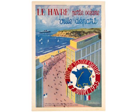
Lot 3501
Original vintage sport advertising poster for the Tour of France cycling race of 1955 and its departure city of Le Havre: Le Havre, porte oceane, ville depart - Tour de France cycliste, July 7, 1955. Great artwork by French artist Melis Seul depicting the riders racing along the Channel coast and a map showing the route of the 1955 race. The Tour de France is an annual men's multiple stage bicycle race primarily held in France, while also occasionally passing through nearby countries. Like the other Grand Tours (the Giro d'Italia and the Vuelta a España), it consists of 21 day-long stages over the course of 23 days. The race was first organized in 1903 to increase sales for the newspaper L'Auto and is currently run by the Amaury Sport Organisation. The race has been held annually since its first edition in 1903 except when it was stopped for the two World Wars. As the Tour gained prominence and popularity, the race was lengthened and its reach began to extend around the globe. Participation expanded from a primarily French field, as riders from all over the world began to participate in the race each year. The Tour is a UCI World Tour event, which means that the teams that compete in the race are mostly UCI WorldTeams, with the exception of the teams that the organizers invite. Good condition, faint creases, staining and foxing in margins. Country: France, year of printing: 1955, designer: Melis Seul, size (cm): 59.5x40

Lot 2600
Original vintage British Rail travel poster advertising the Isle of Man - So easy to reach by rail and sea. Published by British Railways, the poster depicts a map of the island showing roads and railways and is surrounded by 8 photographic images of places of interest. Very good condition, folded as issued, faint creases. Country: UK, year of printing: 1960s, designer: Unknown, size (cm): 101x126.5

Lot 4804
Original vintage Soviet propaganda poster Europe - Nuke Free Zone! Featuring a great image of a woman shouting with a map of Europe in the background. The word STOP uses an anti-bomb sign in place of the 'O'. The Cold War was a period of geopolitical tension between the Soviet Union with its satellite states (the Eastern Bloc), and the United States with its allies (the Western Bloc) after World War II. A common historiography of the conflict begins between 1946, the year U.S. diplomat George F. Kennan's "Long Telegram" from Moscow cemented a U.S. foreign policy of containment of Soviet expansionism threatening strategically vital regions, and the Truman Doctrine of 1947, and ending between the Revolutions of 1989, which ended communism in Eastern Europe as well as in other areas, and the 1991 collapse of the USSR, when nations of the Soviet Union abolished communism and restored their independence. The term "cold" is used because there was no large-scale fighting directly between the two sides, but they each supported major regional conflicts known as proxy wars. The conflict split the temporary wartime alliance against Nazi Germany and its allies, leaving the USSR and the US as two superpowers with profound economic and political differences. Very good condition, small tear. Country: Russia, year of printing: 1983, designer: M. Hetman, size (cm): 66x49
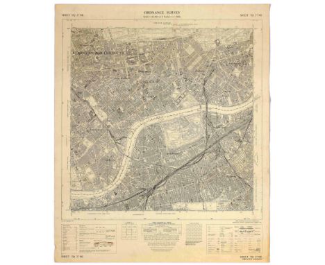
Lot 2622
Original vintage ordnance survey map for Chelsea and Kensington in Greater London - Sheet TQ 27 NE Greayer London. Key below with information on how to read boundaries, roads buildings and travel routes. Good condition, creasing, staining, small tears in margin. Country: UK, year of printing: 1967, designer: Unknown, size (cm): 67x56
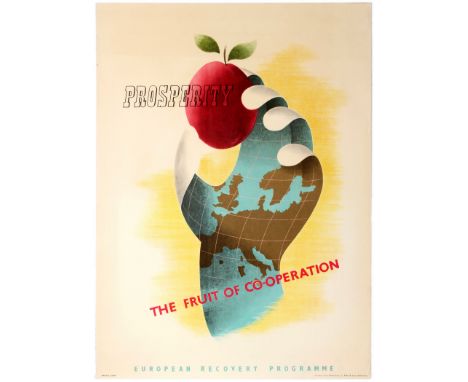
Lot 4511
Original vintage propaganda poster for the post-war US sponsored European Recovery Program (1948) known as the Marshall plan - ERP, Prosperity The Fruit of Co-operation. Great design by Brian E. Dear depicting a stylised hand covered with the map of Europe holding a red fruit. This design was submitted to the Intra-European Cooperation for a Better Standard of Living poster competition on the theme of cooperation and economic recovery that was held by NATO in Europe for the Marshall Plan. The Marshall Plan (officially the European Recovery Program, ERP) was an American initiative passed in 1948 to aid Western Europe, in which the United States gave over $12 billion (nearly $100 billion in 2018 US dollars) in economic assistance to help rebuild Western European economies after the end of World War II. Replacing the previous Morgenthau Plan, it operated for four years beginning on April 3, 1948. The goals of the United States were to rebuild war-torn regions, remove trade barriers, modernize industry, improve European prosperity, and prevent the spread of Communism. The Marshall Plan required a reduction of interstate barriers, a dropping of many regulations, and encouraged an increase in productivity, as well as the adoption of modern business procedures. Very good condition, faint staining and slight creases in margins. Country: Netherlands, year of printing: 1950s, designer: Brian E. Dear, size (cm): 74.5x54.5

Lot 3302
Original vintage advertising for a Chess tournament held by the Moscow Regional Council of Physical Education in Kaluga. Separate events for male and female players. Great typographic design with an illustration of a chess board. Map on reverse. Good condition, folds, tears, small paper losses, browning. Country: Russia, year of printing: 1934, designer: Unknown, size (cm): 74x52

Lot 2501
Original vintage British Rail travel poster promoting rail travel to The Clyde Coast and Loch Lomond - For pleasures sailings in glorious scenery. Published by British Railways and The Caledonian Steam Packet Company Limited, the poster shows a relief map of the area complete with railway route, illustrated by artist W. C. Nicolson. Loch Lomond is a freshwater Scottish loch which crosses the Highland Boundary Fault, often considered the boundary between the lowlands of Central Scotland and the Highlands. Traditionally forming part of the boundary between the counties of Stirlingshire and Dunbartonshire, Loch Lomond is split between the council areas of Stirling, Argyll and Bute and West Dunbartonshire. Its southern shores are about 23 kilometres (14 mi) northwest of the centre of Glasgow, Scotland's largest city. The Loch forms part of the Loch Lomond and The Trossachs National Park which was established in 2002. Very good condition, folded as issued, faint creases. Country: UK, year of printing: 1950s, designer: W. C. Nicolson, size (cm): 101x127

Lot 3304
Original vintage advertising for a Chess and Checkers tournament held by the Kaluga Regional Council of Physical Education. Match between Moscow and Kaluga. Great typographic design with an illustration of a chess board. Map on reverse. Good condition, folds, tears, small paper losses, browning, creasing, staining. Country: Russia, year of printing: 1930s, designer: Unknown, size (cm): 78x55
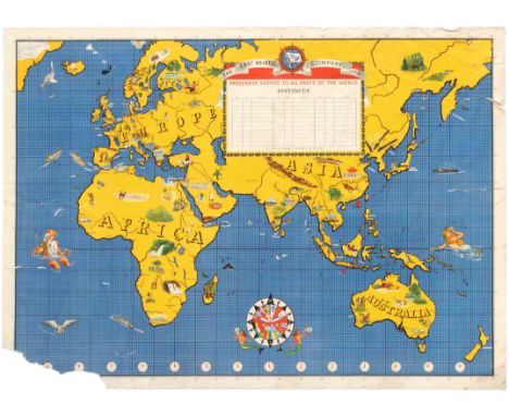
Lot 1314
Original vintage advertising poster for The East Asiatic Company Ltd featuring a great illustrated map including landmarks, people and nature from Africa, Europe, Australia and Asia. Mythical beings and a compass decorate the sea. Blank table for dates and distances to be written appears in the centre. Compass at the bottom of the map shows flags of the countries in which the company operated, including one for Nazi Germany. The East Asiatic Company was founded by Hans Niels Andersen in Copenhagen in 1897. Service which would eventually include both passenger and freight lines between the Danish capital, Bangkok and the far east was the initial objective. Routes to include the Baltic and Black Seas were established when in 1899, the subsidiary Russian East Asiatic Steamship Co. of St. Petersburg was formed. Europe-Asia operations widened when the firm, Est Asiatique Francais of Paris, followed in 1902, the new Danish West India Company, in 1905 and the Siam Steam Navigation Company, in 1908. The second of these was eventually renamed Thai Navigation Co. after the Thai government took it over in 1941. For trade in the South of Africa, the Swedish East Asiatic Company later began regular trips. The subsidiary Russian American Line began sailing to North America in 1916, continuing until 1917. Another, the Baltic American Line, continued the service under the Danish flag from 1921 to 1930. EAC was also involved in shipping for hire with tramp operations beginning in 1915 under the subsidiary D/S A/S Orient of Copenhagen. The company was a pioneer in development of large, commercial motorships with President Andersen placing an order with Burmeister & Wain, headed by the engineer and diesel marine engine pioneer, Ivar Knudsen, for two motorships, MS Selandia and MS Fionia, to be built by that firm. Selandia began operation in 1912 after maiden voyage with the Danish crown prince and princess aboard followed by a visit to London where the ship created great interest with visits by Winston Churchill, admirals and influential shipping figures who then remained aboard for a voyage to Antwerp.[2] A third contracted ship, Jutlandia, was built in Scotland by Barclay, Curle & Company and became the second large motorship in commercial service with any company. By 1935 the company was operating twenty-seven motorships, including a new MS Jutlandia. In these middle years, business grew considerably. The United Baltic Corporation was formed as a partnership with Andrew Weir & Co. in 1919. The early 1920s saw services extend from Copenhagen to South Africa, Cuba, Australia, Mexico and North Pacific ports. New York and, later, Philadelphia, Baltimore or Norfolk, Virginia were among the ports of call added for ships on the north Pacific route in 1940. Connections between Vancouver and the far east were handled by Johnson Walton Steamships Ltd of Vancouver, when they were acquired in 1949. Poor condition, creasing, tears, paper losses, stains. Country: Denmark, year of printing: 1930s, designer: Unknown, size (cm): 94x68cm

Lot 2304
Original vintage pictorial map of Sweden / Sverige published by The Swedish Traffic Association. Great illustration depicting annotated illustrations of Swedish locations, landmarks, animals, people, attractions, boats, trees, and jobs. Red sun in the corner named the midnight sun with ferry routes from Oslo, Gothenburg and Stockholm to Hamburg and Berlin. Printed in Sweden by A.B. Kartografiska Institutet. The Cartographic Institute AB was a Swedish company for the production of maps. The company was founded in 1915 by Magnus Lundqvist under the name Cartographic Office . From 1922, they were subsidiaries of Sweden's lithographic printing companies (later Esselte) and were merged with the Central Printing House. The Cartographic Institute later renamed the Esselte Map Service , and was sold by 1990. Fair condition, creasing, backed on ripped black paper, tears, punched holes. Country: Sweden, year of printing: 1931, designer: Unknown, size (cm): 90.5x58


Lot 2404
Original vintage travel poster featuring an illustrated map of Cambridge, "This immense & glorious work of fine intelligence...". Published by Pictorial Maps Ltd for the Travel Association of Great Britain and Northern Ireland, this colourful pictorial map by artist Kerry Lee depicts historical and contemporary Cambridge in a whimsical, humourous manner which recalls the work of MacDonald Gill, creator of the 1913 "Wonderground Map of London." Tthis poster was part of a series of posters designed by Kerry Lee, also including maps of London, Oxford and Stratford-upon-Avon. Good condition, fold and small tear in left margin, faint foxing and staining. Country: UK , year of printing: 1948, designer: Kerry Lee, size (cm): 56.5x68.5 (Horizontal)


Lot 133
A map by Abraham ORTELIUS: Daniae Regni Typus. Cornelius Antoniades Descripsit: together with (on same sheet), Cimbricae Chersonesi nunc Ivtiae descriptio, auctore Marco Iordana. each map 34cm x 24cm within mount, hand-coloured, strapwork titles, galleon and monster at sea. (Antwerp), 1595 (or later), framed and glazed.


Lot 157
A large 18th century map of Northamptonshire, Eyre (Thomas & Jefferys Thomas), The county of Northampton as surveyed and planned..., 2nd edition, published William Faden, 1791, uncoloured large scale map, engraved by William Faden on four sheets framed as one, two engraved vignettes of Queen's and Geddington Cross, glazed and framed, 133 by 130cm.


-
109182 item(s)/page