We found 109198 price guide item(s) matching your search
There are 109198 lots that match your search criteria. Subscribe now to get instant access to the full price guide service.
Click here to subscribe- List
- Grid
-
109198 item(s)/page


Lot 14
Burton (Richard F.). The Lake Regions of Central Africa. A Picture of Exploration, 1st edition, 2 volumes, 1860, 12 chromoxylograph plates, folding map (torn without loss), wood-engraved illustrations, a couple of leaves with marginal tears from rough opening, a few leaves at front of volume 2 detaching, some water stains and light spotting, contemporary previous owner signature at head of volume 1 title, original brown blindstamped cloth, spines and extremities faded, water stain to volume 2 lower cover, 8vo Penzer pages 65-66. John Hanning Speke accompanied Burton on the expedition, and due to their mutual animosity is described by Burton in the Preface as "unfit for any other but a subordinate capacity." (2)

Lot 101
Asia. To the Right Honourable William Lord Cowper, Lord High Chancellor of Great Britian. This map of Asia according to ye newest and most exact observations is most humbly dedicated..., published D. Midwinter, Thos. Bowles and Philip Overton, circa 1732, engraved map with contemporary outline colouring, inset maps of Nova Zembla, British factories in Chusan and Amoy, The Hellespont, Bombay, The Gulf of Smyrna and The Hugli River, occasional marginal closed tears, slight creasing, 580 x 950 mm (1)

Lot 109
British Isles Speed (John), Britain as it was devided in the tyme of the Englishe Saxons especially during the Heptarchy, published John Sudbury & George Humble, [1627], hand coloured engraved map, ornate strapwork cartouche, compass rose and numerous rhumb lines, the vertical margins decorated with fourteen vignettes of Saxon kings and historical scenes, small closed tear skillfully repaired on veso, very slight staining, 380 x 510 mm, English text to verso (1)
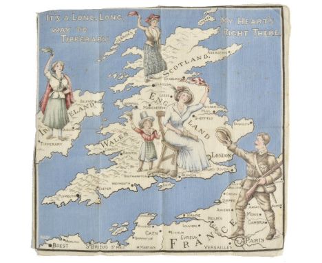
Lot 161
Propaganda map handkerchiefs. It's a Long, Long way to Tipperary - My Heart's right there, circa 1915, colour printed cotton handkerchief, showing a British Tommy heading for the Western front, waving to his imagined wife or sweetheart personified by each of the four home nations, 320 x 330 mm, together with Nippon Times - Unconditional Surrender by Japs completed at 20 minute ceremony. The end of the long road back, [1945], printed in green on silk, showing a map of Japan with the flags of the allied nations, blossom carrying doves and boughs of cherry blossom, 420 x 410 mm The second described item was an American produced commemorative silk souvenir for the US Army publication 'The Nippon Times'. It appeared in a number of different colours and formats and proved a popular gift amongst American GIs & servicemen returning to the United States. (2)
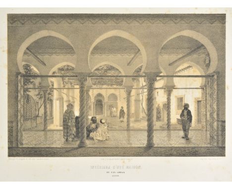
Lot 8
Berbrugger (Louis Adrien). Algerie Historique, Pittoresque et Monumentale, (plates only), Paris, 1843, one lithograph map hand-coloured in outline, 58 lithograph plates, mostly tinted, some marginal tears & fraying, dust-soiling, spotting and browning, disbound folio Sold as a collection of plates. (1)
Lot 213
*Prints & engravings. A mixed collection of approximately 500 prints and engravings, mostly 19th century, including topographical views, military, natural history, architecture and antiquities, various sizes and condition, together with the map volume of A. C. Smiths 'British and Roman Antiquities of Wiltshire, subtitled A Hundred Square Miles Round Abury, 1884, publisher's cloth gilt, waterstained and frayed, folio (approx.500)

Lot 22
Dunne (John Hart). From Calcutta to Pekin; Being Notes taken from the Journal of an Officer Between those Places, 1st edition, Sampson Lowe, 1861, engraved portrait frontispiece and folding map, publisher's advert leaf at front and 16 pp. catalogue at rear, original blind-stamped red cloth gilt, a few minor marks, 8vo Uncommon. (1)
Lot 62
Yorkshire. A collection of thirty-four volumes relating to Yorkshire topography, history and natural history, mostly 19th & early 20th century, including Phillips (John), The Rivers, Mountains and Sea-coast of Yorkshire, subscribers' edition, published John Murray, 1853, frontispiece of the elevations in the county of Yorkshire, numerous lithographic illustrations, index and advertisements bound at rear, later endpapers, modern cloth gilt, 8vo, together with White (William), History, Gazetteer and Directory of the East and North Ridings of Yorkshire..., published Robert Leader, Sheffield, 1840, frontispiece of a large folding engraved map by J. H. Franks with contemporary outline colouring, advertisements bound at rear, slight spotting throughout, contemporary cloth with printed label to spine, 8vo, with Hargrove (E.), The Yorkshire Gazetteer or a Dictionary of the Towns, Villages and Hamlets, Monasteries and Castles, Principal Mountains, Rivers, &c...., 2nd edition, Knaresborough: Hargrove and Sons, 1812, additional half title, frontispiece of a folding engraved map by John Cary with contemporary outline colouring, index and publisher's advertisements bound at rear, contemporary boards with printed title to upper siding and advertisements to rear, untrimmed, frayed and stained, spine partially lacking, 8vo, plus Parsons (Edward), The Civil, Ecclesiastical, Literary, Commercial and Miscellaneous History of Leeds, Halifax, Huddersfield, Bradford, Wakefield, Dewsbury, Otley and the Manufacturing District of Yorkshire, 2 volumes, published Frederick Hobson, Leeds, 1834, frontispiece of a large folding engraved map of the plan and section of the Railway from Leeds to Selby by G. Cruchley, hinges and joints weak and cracked, publishers green cloth with printed paper labels to spines, frayed with spines near detached, 8vo, and Tuke (T.), General View of the Agriculture of the North Riding of Yorkshire with observations on the means of improvement, published W. Bulmer, 1794, additional half title, engraved map with contemporary hand colouring, later endpapers, modern card boards, slim 8vo, and Langdale (Thomas), A Topographical Dictionary of Yorkshire containing the names of all the Towns, Villages, Hamlets, Gentlemen's Seats &c. in the county of York..., 2nd edition, Northallerton: J. Langdale and others, 1822, folding engraved map with contemporary outline colouring by T. Langdale, folding table of distances, tipped in errata slip, index and folding summary and printed errata at rear, later endpapers, contemporary half calf, rebacked retaining part of original spine, worn and rubbed, 8vo, plus The Universal Magazine, Volume 99, 1796, engraved allegorical frontispiece, title with near contemporary ownership signature, four engraved plates and four uncoloured folding engraved maps by B. Baker, occasional spotting, contemporary half calf, worn and rubbed, 8vo, with Dodsley (R. & Kitchin T.), [England Illustrated..., Yorkshire section only], circa 1765, lacking title, containing three uncoloured engraved maps by T. Kitchin and one engraved view, later endpapers, adhesion scars to front pastedown from removal of bookplate, 20th century cloth gilt, faded and sunned, slim 4to, plus Cox (Thomas & Hall Anthony), Magna Britannia et Hibernia Antiqua et Nova, (Yorkshire portion only) circa 1730, two uncoloured engraved folding maps by Robert Morden, bookplate of Edmund Camplin, modern green leatherette gilt, a little worn, 8vo, together with another twenty-four volumes and pamphlets similar, various sizes and condition (34)

Lot 143
Map game. Wallis (Edward), Wallis's Picturesque Round Game of the Produce and Manufactures of the Counties of England & Wales, circa 1830, aquatint map with contemporary hand colouring, sectionalised and laid on linen, 645 x 500 mm, bound in contemporary cloth with gilt title to upper board, boards a little faded and with slight wear to extremities Supplied with photocopy of the original book of rules and explanation. (1)
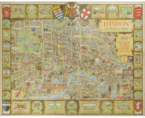
Lot 138
London. Lee (Kerry), London. The Bastion of Liberty, circa 1950, large colour lithograph pictorial map of London, slight staining and fraying to margins, laid on card, 990 x 1230 mm A charming portrait of the artist Kerry Lee (1902 - 1988) can be seen in the lower right corner, his name signed on an easel with his faithful dog Jim sitting by his side. Kerry Lee produced two colour pictorial maps for British Railways in the 1930s which were revised up until the 1950s. These railway posters are very much in the style of Macdonald Gill. (1)

Lot 179
World. Speed (John), A new and accurat Map of the World. Drawne according to ye truest Descriptions, latest Discoveries & best Observations yt have beene made by English or Strangers, published Thomas Bassett & Richard Chiswell, [1676], hand coloured engraved map of the world on a hemispheral projection, insular California, decorated with engraved vignettes of the four elements, portraits of eminent explorers and celestial diagrams, central fold partially strengthened on verso, 400 x 525 mm, English text to verso R. W. Shirley. The Mapping of the World, 317. (1)
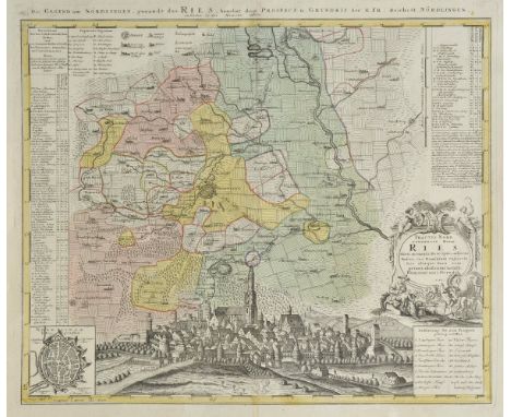
Lot 132
Germany. Homann (Johann Baptist, heirs of), Tractus Nordlingensis Germ. Ries dicti accurata descriptio..., 1738, engraved map with contemporary hand colouring, numbered key, inset town plan of Nordlingen, 495 x 590 mm, together with Wyld (James), The Prussian Government of Stralsund (formerly Swedish Pomerania), circa 1850, engraved map with contemporary outline colouring, inset plan of Stralsund, slight offfsetting, 570 x 570 mm The first described map depicts the area surrounding Nordlingen, in the northern portion of Swabia in Bavaria. Towns of various sizes, castles, mills, roads, and even fields are graphically illustrated. At bottom is a large view of the city, dominated by the Gothic church of St. George with its bell-tower named "Daniel." A numbered key identifies seventeen important locations on the map. Nordlingen was the site of two battles during the Thirty Year's War, and remains one of the few cities in Germany that maintains a fully preserved wall surrounding the city. (2)

Lot 96
Africa. Speed (John), Africae described, the manners of their habits and buildings newly done into English, Published Thomas Bassett & Richard Chiswell, [1676], hand coloured engraved 'carte-a-figures' map, costumed figures to vertical margins, eight oval vignettes of principal cities along upper margin, central fold partially repaired on verso, 395 x 515 mm, English text on verso (1)

Lot 33
Pardoe (Julia). The Beauties of the Bosphorus, Illustrated in a Series of Views of Constantinople and its Environs, circa 1840, two engraved portrait frontispieces, additional engraved title, map and 84 engraved plates after William Bartlett, occasional light offsetting and spotting, small previous owner ink stamp, contemporary half calf, rubbed with some wear to spine ends, 4to, together with The Oriental Annual, or Scenes in India; Comprising Twenty-Five Engravings from Original Drawings by William Daniell, and a Descriptive Account by the Rev. Hobart Caunter, 1834, engraved frontispiece, additional title and 23 engraved plates (two detached), some light spotting, contemporary presentation inscription, all edges gilt, contemporary morocco gilt, spine and edges a little rubbed, 8vo, plus Footsteps of Our Lord and His Apostles in Syria, Greece and Italy... by W.H. Bartlett, 3rd edition, 1852, engraved map, frontispiece, additional title, 20 engraved plates, advertisements at end, first few leaves detaching, light spotting, previous owner inscription, original blindstamped cloth gilt, joints splitting, small stains, 8vo (3)
Lot 76
Mawe (John). The Mineralogy of Derbyshire: With a Description of the Most Interesting Mines in the North of England, in Scotland, and in Wales; and an Analysis of Mr. Williams's Work, Intitled "The Mineral KIngdom." Subjoined is a Glossary of Terms and Phrases used by Miners in Derbyshire, 1st edition, 1802, engraved frontispiece, single-page map and 2 plates (complete), 16 page publisher's list at rear, contemporary marginal notes, light toning and occasional spotting, first & last few leaves with small dampstain to lower margin at gutter, edges untrimmed, hinges repaired, original boards, rebacked, wear to board edges, 8vo Upcott p.143 (1)
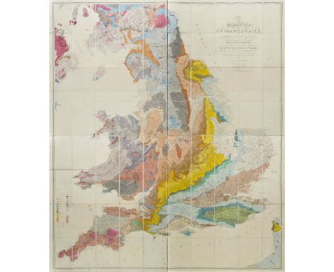
Lot 70
Greenough (George Bellus). A Physical and Geological Map of England & Wales... (on the basis of the original Map of Wm. Smith 1815), Revised and Improved under the Superintendence of a Committee of the Geological Society of London, from the Maps of the Geological Survey of Great Britain, 1836-63 and Maps and Documents contributed by Sir R.J. Murchison, Professor Phillips, Joseph Prestwich, R. Godwin Austen, and others, Published by the Geological Society, July 1865 [but circa 1877], comprising four hand-coloured engraved sheets (on J. Whatman watermarked paper dated 1877) each sectionalised on linen, calligraphic title and table of explanation, few minor spots but generally very clean, marbled endpapers, sheet size of each approximately 975 x 850mm, total size approximately 1950 x 1700mm Scarce. This is the third state of Grennough's map and the first to acknowledge William Smith. Greenough was one of the founding members of the Geological Society of London, and it's first president until 1811. 'In 1808 he first sketched the boundary-lines of the various strata in England and Wales, and in 1810 he travelled over a great part of the country for the purpose of mapping it. At the request of the Geological Society he then, with the help of Conybeare, Buckland, and Henry Warburton, coloured a large scale-map drawn by Webster, and in 1820 published it in six sheets' (DNB). It is understood that Greenough reproduced William Smith's geological map of 1815, and this possibly drove Smith into debtors' prison as a consequence. Published a decade after Greenough's death, this edition was produced by the Geological Society under a committee that included William Smith's nephew, the Professor of Geology in Oxford, John Phillips. This particular edition of the map was the first to acknowledge its connection with Smith in its title. (4)
Lot 156
Nottinghamshire. Speed (John), The Countie of Nottingham described, The Shire townes situation and the earls thereof observed, published Thomas Bassett & Richard Chiswell, [1676], uncoloured engraved map, inset town plan of Nottingham, slight creasing, 385 x 510 mm, no text to verso, together with Bell (Thomas & Son, publisher), Plan of the Borough of Nottingham shewing surface levels by contour lines and geological formation, circa 1870, lithograph with contemporary hand colouring, slight dust soiling and marginal creasing, 620 x 450 mm, with several black & white facsimile maps, various sizes and condition (approx.26)
Lot 312
Pope (Alexander). Iliad/Odyssey of Homer, 9 volumes, 1771, two engraved portrait, folding map, four engraved plates (two folding), occasional light toning, previous owner signature to title, contemporary calf, spines with red and green labels, volume 5 spine torn at foot and small loss to first compartment, edges rubbed, 8vo (9)
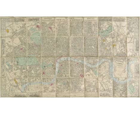
Lot 140
London. Wyld (James), Wyld's New Plan of London, published June 1866, folding lithograph map with sparse contemporary hand colouring, laid on linen, titles repeated in French & German, uncoloured vignette views of London landmarks in the margins, 555 x 950 mm, publisher's boards with red and grey printed wrappers, worn (1)
Lot 286
Fuller (Thomas). The Historie of the Holy Warre, third edition, Cambridge, printed by Roger Daniel, 1647, additional engraved title (some soiling and fraying to margins), Declaration of the Frontispice present but loose and soiled with fraying, folding map of the Holy Land present (also frayed and soiled with closed tears), wood engraved head- and tail-pieces and initials, occasional soiling elsewhere, early ownership inscriptions and doodles to front and rear endpapers, including one inscription dated 1660 to front endpaper, contemporary calf, rubbed and somewhat worn, with upper cover detached, folio, together with Commines (Philip de), The History of Philip de Commines, Knight, Lord of Argenton, Fourth Edition, Corrected, with Annotations, printed for Samuel Mearne, John Martyn, and Henry Herringman, 1674, woodcut initials, contemporary mottled calf, rubbed and joints cracked with some wear, folio, plus other antiquarian interest, various, including Walter Raleigh, History of the World, 7th edition..., to which is added, The Life of the Author, newly compil'd, 1733, etc (9)

Lot 97
Africa. Moll (Herman), To the Right Honourable Charles Earl of Peterborow and Monmouth &c. This map of Africa, according to ye newest and most exact observations is most humble dedicated..., published D. Midwinter, Thos. Bowles and Philip Overton, circa 1732, engraved map with contemporary outline colouring, inset view of the Cape of Good Hope, and three vignettes of forts at St. Helena, Good Hope and Guinea, occasional marginal closed tears, some dust soiling to left hand vertical margin, slight creasing, 590 x 970 mm (1)

Lot 173
South America. Moll (Herman), To the Right Honourable Charles Earl of Sunderland and Baron Spencer of Wormleighton, one of Her Majesty's Principal Secretaries of State &c. This Map of South America, according to the newest and most exact observations is most humbly dedicated..., published J. & T. Bowles, P. Overton and John King, circa 1735, engraved map with contemporary outline colouring, inset view of Potosi, old folds, very slight abrasion to printed surface, 575 x 975 mm, with another copy similar (2)

Lot 159
Palestine. Assheton (J. T.), An Historical Map of Palestine or the Holy Land, published Samuel Leigh, 1825, decorative map, engraved by Sidney Hall, sparse contemporary outline colouring, laid on linen, some abrasion to printed surface, some fraying to margins, toned overall, near contemporary battens, upper batten detached, 990 x 690 mm (1)

Lot 164
Railway map. Bradshaw (George), Map & Sections of the Railways of Great Britain. Dedicated by Permission to James Walker F.R.S. L & E President of the Institution of Civil Engineers, published Manchester, G. Bradshaw, 1839, large map of the British Isles, engraved by J. Dower, contemporary outline colouring, sectionalised and laid on linen, inset map of London, calligraphic cartouche, compass rose and thirty-three sectional profiles of the various railways of the British Isles, some off setting to cartouche, slight staining, 1630 x 1020 mm, marbled endpapers, bound with Tables of the Gradients to Bradshaw's Map of the Railways of Great Britain, Containing Particulars of Lengths, Levels and Gradients of all the Principal Railways in the Kingdom, 1839, 30 page pamphlet of tables of gradients, bound in contemporary blindstamped morocco boards with gilt title to upper siding, re-backed but retaining original spine, bumped and with slight wear to extremities The first complete railway map. (1)
Lot 71
Headrick (James). View of the Mineralogy, Agriculture, Manufactures and Fisheries of the Island of Arran. With Notices of Antquities, and Suggestions for Improving the Agriculture and Fisheries of the Highland and Isles of Scotland, 1st edition, Edinburgh, 1807, folding engraved map, light offsetting to title, bookplate of Archibald Earl of Eglinton, contemporary half calf gilt, extremities rubbed, 8vo (1)
Lot 65
Darwin (Charles). Geological Observations on the Volcanic Islands and Parts of South America visited during the Voyage of H.M.S. 'Beagle', 2nd edition, 1876, folding engraved map, folding hand-coloured lithograph cross section plan, four folding plates, illustrations & diagrams to text, occasional scattered spotting, contemporary half calf, gilt decorated spine with contrasting morocco labels, extremities slightly rubbed, 8vo (1)


Lot 99
Americas. Speed (John), America with those known parts in that unknowne worlde both people and manner of buidings, published Thomas Bassett & Richard Chiswell, [1676], hand coloured engraved 'carte-a-figures' map with costumed figures to the vertical margins amd eight oval vignettes of principal cities to upper margin, insular California, one marginal repaired closed tear, 400 x 515 mm, English text to verso (1)

Lot 168
Satirical map. Lehmann-Dumont (Karl), Humoristische Karte von Europa im Jahre 1914, published Dresden, 1914, colour printed photolithograph allegorical map, inset map of Japan, old folds with small holes where folds cross, some marginal closed tears and slight fraying, 350 x 490 mm An allegorical depiction of Europe, with the bias on Germany and Prussia. Undoubtedly published for amusement it concentrates on the national characteristics and the foibles of each nation, but there is also a more disturbing element of propoganda. The date of publication and the depiction of national stereotypes will prove to be highly prophetic of the carnage that was shortly to engulf the continent. (1)

Lot 191
Yorkshire. Saxton (Christopher & Webb William), Untitled map of Yorkshire, circa 1645, uncoloured map engraved by Augustus Ryther on two conjoined sheets, inset town plan of York (replacing the coat of arms on the 1579 edition) and a vignette panorama of Hull (replacing the title cartouche of the 1579 edition), trimmed to neatline with very slight loss to strapwork margins, occasional repaired marginal closed tears, one horizontal fold as well as the vertical, slight creasing, 520 x 725 mm Published in 'The Maps of all the Shires of England and Wales'. Scarce. (1)

Lot 177
World. Cellarius (Christoph), Veteris Orbis Climata ex Strabone, circa 1710, uncoloured engraved map with a ribbon cartouche, surrounded by seven windheads, old folds, right hand vertical margin extended, 210 x 310 mm, together with another five uncoloured engraved maps of the world including four hemispheral maps by Thomas Bowen, various sizes and condition The Cellarius (aka Christopher Keller) map is dominated by an allegorical vignette of the mythological wind god Aiolos whose floating prison island of Aiolia constrained the storm sprits Anemoi Thuellai and Aellai. Aiolos is shown restraining the North Wind, depicted as a winged dog. (6)
![London. Braun (Georg & Hogenberg Frans), Londinum Feracissimi Angliae Regni Metropolis, published Cologne, [1572 - 1574], ha](https://cdn.globalauctionplatform.com/4e304000-5d76-46f9-99b3-a83c00ab795a/110f63cc-bde3-4e23-be0e-0e1c11e78a13/468x382.jpg)
Lot 141
London. Braun (Georg & Hogenberg Frans), Londinum Feracissimi Angliae Regni Metropolis, published Cologne, [1572 - 1574], hand coloured engraved city plan, two printers folds, slight staining to margins but not affecting image, 330 x 490 mm, French text to verso J. Howgego. Printed Maps of London 1553 - 1850. No. 2. Intermediary state between states 1 and 2. The spelling of 'Westmester' has been changed to 'Westmuster', as in state 2 but the Royal Exchange is not shown, as in state 1. A seminal map published as the first plate in the first volume of the first systematic town atlas 'Civitates Orbis Terrarum'. (1)
Lot 55
Nash (Thomas). Collections for the History of Worcestershire, 2 volumes, 1st edition, 1781-1782, folding engraved map frontispiece to volume 1, engraved vignette title to each volume, 83engraved plates & plans, numerous engraved illustrations to text and 20 folding pedigrees, supplement bound in at rear of volume 2, repaired horizontal closed tear to plate of "Monument of Rowland Berkeley", armorial bookplate of Richard Barton Dadgson, all edges gilt, contemporary calf gilt, joints to volume 1 split and lower board loose, volume 2 with detached boards, rubbed and worn, folio (2)

Lot 105
British Isles. Jansson (Jan), Britannia prout divisa suit temporibus Anglo-Saxonum praesertim durante illorum Heptarchia, circa 1646, hand coloured engraved map, ornate cartouche, compass rose and numerous rhumb lines, the vertical margins decorated with fourteen historical scenes and portraits, 420 x 520 mm, no text to verso (1)
Lot 27
Keppel (Captain the Hon. George). Personal Narrative of a Journey from India to England, by Bussorah, Bagdad, the Ruins of Babylon, Curdistan, the Court of Persia, the Western Shore of the Caspian Sea, Astrakhan, Nishney Novogorod, Moscow, and St. Petersburgh, in the Year 1824, 2 volumes, 2nd edition, Henry Colburn, 1827, hand-coloured lithograph frontispiece to each, tinted lithograph plate, and folding linen-backed engraved map, few vignette illustrations to text, without 10 page publisher's catalogue at rear of volume 2, contemporary half calf gilt, extremities rubbed, 8vo Atabey 631. Three editions of Keppel's account of his return from India to England were published in 1827, the third with the title Personal Narrative of Travels in Babylonia and with an additional plate. The journey, which began in January of 1824, took him through Iraq, Kurdistan, and into Russia. (2)
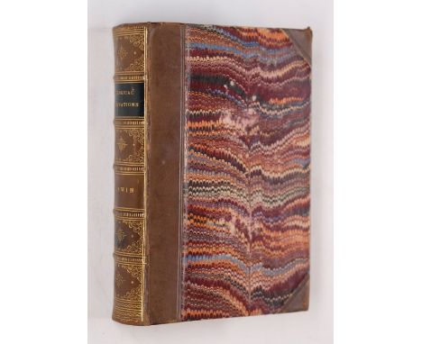
Lot 51
Lewis (Samuel, & Co., publishers). Atlas to the Topographical Dictionaries of England and Wales, 1848, frontispiece of a folding engraved map of England & Wales with contemporary outline colouring, folding engraved map of London, one closed tear running along an old fold, and 51 engraved maps (including 12 folding) all with contemporary outline colouring, slight spotting and dust soiling, hinges and joints cracked and weak, publisher's cloth gilt, spine partially lacking, worn and rubbed, slim 4to (1)
![Scotland. Speed (John), The Kingdome of Scotland, published John Sudbury & George Humble, [1627], hand coloured engraved map,](https://cdn.globalauctionplatform.com/4e304000-5d76-46f9-99b3-a83c00ab795a/77823a9f-fefe-4e83-bd45-67ab71d1e9f5/468x382.jpg)
Lot 170
Scotland. Speed (John), The Kingdome of Scotland, published John Sudbury & George Humble, [1627], hand coloured engraved map, inset map of the Orkney Islands, four costumed figures to vertical margins, thread margins but extended with later paper, central fold strengthened on verso, 385 x 515 mm, English text on verso (1)
Lot 48
Green (Valentine). The History and Antiquities of the City and Suburbs of Worcester, 2 volumes in one, 1796, engraved portrait frontispiece, folding plan (closed tear repaired to verso) and 23 engraved plates (one double-page & one folding), some light spotting, contemporary marbled calf, gilt decorated spine with morocco title label, upper board detached, lower joint cracked, extremities rubbed, 4to, contained in modern archival box, together with [Rudder, Samuel], The History and Antiquities of Cirencester. Including the Civil and Military Affairs of that Antient Town..., Cirencester: S. Rudder, 1780, manuscript annotation to title, two folding engraved plates, contemporary gilt decorated red morocco, gilt armorial of Lord Stuart de Rothesay to centre of each board, title label deficient, upper board detached, some wear, 8vo, plus Collinson (Rev. John), The History and Antiquities of the County of Somerset, Collected from Authentick Records..., 3 volumes, Bath: R. Cruttwell, 1791, half-titles to volumes 1 & 2 only, folding engraved map frontispiece to volume 1 (detached & with tape repairs to verso), 40 engraved plates, without 'directions to the binder', a few with small repaired tears, modern cloth-backed boards, 4to (Upcott 1146-47) (5)


Lot 169
Scandinavia. Moll (Herman), A New Map of Denmark and Sweden according to ye newest and most exact obervations..., published D.Midwinter. Thos. Bowles and Philip Overton, circa 1732, engraved map with contemporary outline colouring, inset map of the Northern part of Norway, Lapland and Greenland, four inset vignettes of Laplanders, occasional marginal closed tears, 605 x 1100 mm, together with To His most Serene and August Majesty Peter Alexovitz absolute Lord of Russia &c. This map of Moscovy, Poland, Little Tartary and the Black Sea is most humbly dedicated..., published D. Midwinter, P. Overton & Thos. Bowles, circa 1732, engraved map with contemporary outline colouring, inset map of the North part of Russia, slight marginal creasing, 615 x 985 mm (2)
Lot 135
Jigsaw Maps. Humorous Jig-saw puzzle map of London, published 'Geographia' Ltd., circa 1935, 600 piece wooden jigsaw puzzle, lacking key map, approximately 510 x 760 mm (when completed), contained in maker's card box with printed label to upper cover, worn at extremities, together with The World, Exhibition Puzzle of the British Empire, circa 1924, fifty piece wooden jigsaw puzzle contained in maker's cased box with printed label to upper cover, worn at extremities, with England & Wales, New Jig-saw puzzle 'Pictorial map of England', published 'Geographia' Ltd., circa 1935, 600 piece wooden jigsaw puzzle, lacking key map, contained in maker's card box with printed label to upper cover, box damaged, plus The World, World Communication by Cable and Wireless, made by Chad Valley, circa 1930, 150 piece wooden jigsaw puzzle, retaining promotional leaflet, contained in maker's card box with printed label to upper cover, box worn and with some damage Puzzles have not been 'made' but the vendor assures that all are complete. (4)
-
109198 item(s)/page