We found 109182 price guide item(s) matching your search

Refine your search

Year

Filter by Price Range
  • List
  • Grid
  • 109182 item(s)
    /page

Lot 1

Bowen (E.) An Accurate Map Of Devonshire etc, large handcoloured map, inset plan of Plymouth, 580mm x 525mm, n.d., Circa 1760's, framed and glazed.

Lot 1

Greenville Collins (C.) Plymouth (Sound), uncoloured map with decorative cartouche, 570mm x 440mm, n.d., Circa 1693-(Circa 1758), framed and glazed.

Lot 1

(Hondious, J) (after) ....South West England, map with outline handcolouring, 470mm x 370mm, n.d. Circa 1630's, framed and glazed.

Lot 1

Hubner (Mr) A New And Easy Introduction To The Study Of Geography... in two parts, 4th edition, 22 folding maps (some torn), 10 maps, lacks map of North America, Sheep, 8vo 1753.

Lot 1

Jaillot (H.) Le Royaume De France, map with original outline, hand colouring, 600mm x 470mm, 1696, framed and glazed.

Lot 1

Kitchin (T.) An Accurate Map Of Warwickshire, handcoloured, 405mm x 510mm, 1777, framed and glazed.

Lot 1

Morden (Robert) Devonshire, handcoloured map with decorative title cartouche, 415mm x 360m, n.d., Circa 1695, framed and glazed.

Lot 1

Ogilby (John) The Road Map From Exeter To Barnstaple... Devon, 555mm x 430mm, Circa 1675.

Lot 1

Ortelius (after Humphrey Lluyd) *** Cambri Ae Typus, uncoloured map 500mm x 370mm, n.d., Circa 1570's, framed and glazed, together with Kip (W.) (after C. Saxton) Anglesey Comitatus...etc, uncoloured map, 190mm x 260mm, n.d. (1607), framed and glazed (2).

Lot 1

Reduced Ordnance Survey Around Ringwood, scale 2 miles to an inch, a folding linen backed map in cloth covers, published by George Richmond.

Lot 1

Speed (John) Caermaden Both Shyre And Towne Described, uncoloured map, 510mmx 380mm, Bassett & Chiswell, 1662, (loose); Kitchin (T.) An Accurate Map Of Glamorganshire, uncoloured map, 525mm x 350mm, Bowles, Bowles & Sayer, no date, Circa 1760's?, trimmed in top margin, framed and glazed.

Lot 1

Back (Captain) Narrative Of The Arctic Land Expedition, later calf boards, detached, folding map, lithograph and steel plates, 8vo, 1836.

Lot 1

Collinson (Rev. John) The History Of Somersetshire, 3 volumes, folding map, folding plan, map, 43 plates, tooled leather, gilt, 4to, 1791 (3).

Lot 1

Cooke (G. A.) A Topographical And Statistical Description Of The County Of Devon, New edition, frontispiece, folding map, 4 engraved plates, half calf, 12mo, n.d.; Britton (John) And Brayley (Edward Wedlake) Description Of Devonshire, Vol 4 only, frontispiece, title vignette, half calf, binding defective, 8vo, 1810 (2).

Lot 1

Cross's New Plan Of London, a folding linen backed map, card covers, n.d.

Lot 1

Kelly (E. R.) editor, Directory Of Devonshire, map, cloth, defective gilt, 4to, 1883.

Lot 1

Lengths And Levels To Bradshaws Maps Of The Canals, Navigable Rivers And Railways, 1 folding map, cloth, 8vo, 1833.

Lot 1

Merryweather (F. Somner) Half A Century Of Kingston History, half calf, worn, 8vo, 1887; Excursions In The County Of Surrey, folding map, plates throughout, morocco, gilt, 8vo, 1821; a folding linen backed map of The Official Railway Map Of The South Of England, calf, 8vo, n.d. (3).

Lot 1

Moore (Rev. Thomas) The History And Topography Of Devonshire, 2 volumes, 2 frontispieces, 1 title vignette, folding map, 91 engraved plates, re-bound in cloth, 8vo, 1829 (2).

Lot 1

Ordnance Survey Map Of Devon....by Lt. Col. Mudge, scale one inch to one mile, un-coloured, on 8 folding sheets and titled sheet, in original calf covered box, rubbed, 1809. * The First ordnance survey of Devon.

Lot 1

Phillips (M.) The Grand Southern Tour Of England..., a large linen backed folding map, 1821; contained in a slip case.

Lot 1

Smith, C. - English Atlas, 1804, containing general map of England and Wales, County maps divided into hundreds, and an Index, original leather binding, worn, some damage.

Lot 1

OLD HAND COLOURED MAP "NEW MAP OF GLOCESTERSHIRE" DRAWN FROM THE LATEST AUTHORITIES, FRAMED AND GLAZED, Coloured Print after Durer and another colour Print "River and Ducks with Figures"

Lot 1

OLD HAND COLOURED MAP BY CHRISTOPHER SAXON "THE COUNTIE OF RADNAL" FRAMED AND GLAZED

Lot 1

SIGNED PRINT OF DARTMOUTH - FRAMED and a MAP OF DEVON - framed

Lot 1

COOKE, GEORGE ALEXANDER "TOPOGRAPHICAL AND STATISTICAL DESCRIPTION OF THE COUNTY OF HERTFORD..." a copious travelling guide with an illustrated map of thecounty. Printed for C Cooke, a slip pasted onto back endpaper inscribed "C. Cooke's compliments to Mr Bowles and begs his acceptance of these two volumes, September 1814". A book plate of H C Bowles pasted on inside front endpaper. Full calf one vol only

Lot 1

'The Merce or Shirrefdom of Berwick' Handcoloured map of Berwickshire by Timothy Pont

Lot 1

11 Chad Valley GWR jigsaw puzzles, a twin puzzle The Railway Station in partitioned box, Paddington Station, Swansea Docks, A Cornish Fishing Village, Anne Hathaway's Cottage, the Cathedral; Caerphilly Castle, King George V and Speed Locomotives; the St Julien Ferry Boat, all boxed, mostly minor wear for age; plus GW The Freight Train, unboxed and GWR rail route map of the era. All puzzles made up. Puzzle pieces GC to VGC (St Julien missing 3 pieces)

Lot 1

After John Speed - 17th Century hand coloured map of Suffolk with inset town plan for Ipswich and coat of arms (with tear), 39cm x 52cm

Lot 1

After Saxton - 17th Century hand coloured map of Suffolk (with losses), 34cm x 38cm

Lot 1

A 17th Century hand coloured map of Suffolk with coat of arms (minor tear at 6 o'clock), 46cm x 54cm

Lot 1

A 17th Century hand coloured map of Norfolk with coat of arms, 46cm x 54cm

Lot 1

A 17th Century hand coloured map of Essex with coat of arms, 46cm x 54cm

Lot 1

Emanuel Bowen 1714-1767 - An accurate map of the county of Suffolk divided into its hundreds, circa 1755, engraved map hand coloured in outline, ornamental titled cartouche and historical information (some discolouration), 53cm x 71cm

Lot 1

Old Two Sided Puzzle With Map Detail, Decorated Caddy, Pot Carved Figure Etc.

Lot 1

A 19th Century Sampler Map by Agnes Dale, 1848 "The Railways in Great Britain" in later mahogany frame, 56cm x 59cm

Lot 1

Early Victorian rosewood and inlaid wheel barometer, circa 1840, 10ins silvered dial centred with a map of Europe and Asia, with thermometer to the neck, case profusely inlaid with brass and mother of pearl featuring scrolling foliage and birds, height 40ins

Lot 1

YOUNG, GEORGE Rev. A Geological Survey of the Yorkshire Coast: Describing the Strata and Fossils Occurring between the Humber and the Tees, from the German Ocean to the Plain of York. Whitby, 1822, 1/2 calf, slightly rubbed, engraved frontis, 17 hand -coloured engraved plates, hand-coloured double page map, hand coloured double page sections of Strata

Lot 1

CARY, JOHN Cary's New Map of England and Wales with Part of Scotland...London, 1794, half calf, eng title and dedication, 77 numbered hand coloured sections, numbered to 81.

Lot 1

John Ogilby (1600 - 1676), an engraved map, The Continuation Of The Road From York To Chester, section from Warrington with additional route from Manchester to Derby, lightly coloured, 35cm x 45cm

Lot 1

Wellem Blau of Amsterdam, a two page hand coloured map, Derbyshire from twelve volumes of an atlas which included the English counties re-engraved from those of John Speed from 1635, German text to verso, 38cm x 49cm

Lot 1

John Ogilby (1600 - 1676), an engraved map, London to Derby, lightly coloured, 34cm x 46cm

Lot 1

John Speed (c.1552 - 1629), a hand coloured two page map, Nottinghamshire, engraved by Jacobus Hondius from Speed's The Theatre of the Empire of Great Britain from 1611, 39cm x 52xm framed

Lot 1

Robert Morden (died 1703), a hand coloured two page map, Herefordshire, one of a series of fifty of English Counties for a new addition of William Camdens 1610 Britannia published in 1695, 37cm x 44cm

Lot 1

A colour reproduction: After John Speede 15 1/4in. x 20 1/4in. (38.5 x 51.4cm) Map of Northumberland.

Lot 1

A colour reproduction: After John Speede 15in. x 19 3/4in. (38 x 50cm) Map of the Bishoprick and City of Durham.

Lot 1

An antique engraving by: Thomas Kitchin 27in. x 20in. (68.5 x 51cm) A map of Northumberland, with hand colouring, published by R. Sayer, etc., c.1750.

Lot 1

Robert, publ. 1753 - 'Le Royaume d'Angleterre..'; hand-coloured engraved map, 49x52.7cm: Robert, publ. 1754- 'Les Isles Britanniques...'; hand-coloured engraved map, 49.5 x 61cm: together with a lithograph by Daumier titled: 'Voila le moment (passe minuit), ou le calme et la paix regnent veritablement dans les heureux menages..', from Moeurs Conjugales', publ. by Aubert & Cie., Paris, and five reproduction prints after different hands, (8), (unframed).

Lot 1

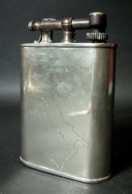
A large plated brass flip-top table lighter, with engraved map of Italy and various inscriptions including 'Al Nostro Capitano Forster, Dai Rastrellateri Mine Del Veneto Natale 1945', 15cm.

Lot 1

IRELAND (W H) - New and Complete History of the County of Kent, 4 vols, 1828-1830, folding map and engraved plates, half-calf; FURLEY (Robert) - History of the Weald of Kent, 2 vols in 3, 1874, cloth; and 7 other topographical works, some bindings a.f (14 vols).

Lot 1

HOLY BIBLE, 2 vols, 1811, Sussex Press, Lewes, printed by John Baxter, map, coloured-in outline, illustrations; Cassell's Illustrated Family Bible, full blind-stamped and gilt calf, brass edges and clasps; and two other editions of the Bible (5 vols).

Lot 1

After Dennis Griffiths Black and white engraving - uncoloured 'A Map of the State of Maryland' Published June 1795 by J Wallace 75cm x 131cm Glazed frame

Lot 1

A facsimile copy of Andrews map of Kent published by H. H. Margary, Lympne Castle Kent, and a small quantity of books relating to famous artists

Lot 1

A map of the Isle of Thanet Published by J Hall bookseller at Margate 16 3/4 x 21 1/4 inches

Lot 1

EDMONDS & LEE (HH & NN) - Brook and River Trouting, first edition 1916, published by the authors, brown cloth (good); PRYCE-TANNATT (TE) - How to Dress Salmon Flies, first edition? 1914, published by A & C Black, green cloth with pictorial decoration to front and spine (very good); RIGHYNI (RV) - Grayling, first edition 1968, signed copy, published Macdonald & Co., brown cloth with pictorial dust wrapper (very Good); TURING (HD) - Where to Fish, 1931, with map, published by The Field, red cloth (good) (4)

Lot 1

BRADLEY (TOM) - Yorkshire Rivers:- The Wharfe, The Nidd, The Ure, The Swale, The Ouse, The Derwent, The Rye, The Esk, and The Aire 1 & 2, each with bird's eye view map of the river and roads adjoining, reproduced from The Yorkshire Weekly Post, first editions from 1890-93 (good, tape on spines) (10)

Lot 1

WALTON (IZAAK) - The Complete Angler, second edition 1854, publ.by Nathaniel Cooke, embossed brown cloth (rubbed); STODDART (THOMAS TOD) - The Anglers Companion to the Rivers and Lochs of Scotland, second edition 1853, with map, publ. by William Blackwood & Son, black cloth (rubbed); BRADLEY (TOM) - The Yorkshire Anglers Guide, first edition 1893, publ. by the author, pictorial cloth (rubbed); ANON - The Art of angling, facsimile of 1577, 1956, publ. by Princetown University Library, marbled boards (very good) (4)

Lot 1

1878 H.M. Stanley and Dr. Ermin Bey: an octagonal pottery plate printed in black with named portraits, a map and views, gilt lined border

Lot 1

Robert Morden coloured engraving Map of Durham 14in. x 16.5in.

Lot 1

Robert Morden engraving Map of Durham 6in. x 8in., a T. Kitchin map of Durham, 6in. x 8.5in. and another coloured map of Durham, 7in. x 4.5in.

Loading...Loading...
  • 109182 item(s)
    /page

Recently Viewed Lots