We found 109198 price guide item(s) matching your search

Refine your search

Year

Filter by Price Range
  • List
  • Grid
  • 109198 item(s)
    /page

Lot 313

Southern Regiments Mockler-Ferryman (A.F.), The Oxfordshire and Buckinghamshire Light Infantry (in the Great War) Chronicle, nd., vols. 1 to 5, (lacking vol 3), cloth; Wheeler (C.), Memorial Record of the Seventh (Service) Battalion, The O.&B.L.I., 1921, cloth; Wright (P.L.), The First Buckinghamshire Battalion, 1914-19, 1920, cloth; Southern (L.J.C.), The Bedfordshire Yeomanry in the Great War, nd., [c1935], folding map, cloth; with thirteen others (20)

Lot 314

South Western and Midlands Regiments Wyrall (Everard), The History of the Duke of Cornwall's Light Infantry, 1914-19, 1932, cloth (re-backed); id., The Gloucester Regiment In the War, 1914-18, 1931, dust wrapper; Wood (W. de B.), The History of the King's Shropshire Light Infantry in the Great War, 1914-18, 1925, cloth; The Northamptonshire Regiment, 1914-1918, nd., lacking map, cloth; Priestley (R.E.), Breaking the Hindenburg Line, The Story of the 46th (North Midland) Division, 1919, cloth; with a quantity of others (qty)

Lot 321

First World War Montgomery (A.), The Story of the Fourth Army in the Battle of the Hundred Days ... 1918, nd., [c1919], 2 vols. incl. map case with 19 folding maps and 5 folding panoramas, 4to., cloth; Sir Archibald Murray's Despatches (June 1916-June 1917), 1920, 2 vols. including portfolio of 4 folding maps, dust wrapper; Gough (H.), The Fifth Army, 1931, cloth; Doyle (Arthur Conan), The British Campaign in France and Flanders 1914-18, 1916-19, 6 vols, 4 in cloth, 2 in half morocco; with three others (14)

Lot 561

[MAP] MORDEN (Robert) Comitatus Rotelandiae Tabula Nova …, [London ca. 1695] engraved map with good margins, uncoloured, title cartouche lower right corner, scale lower left, legend upr. right, original central fold, 11.5 x 14.5 inches [P], f. & g.; and another map (2)

Lot 11

ROBERT DIGHTON (1752-1814) 'Geography Bewitched' coloured print 16cm x 20cm Titled to mount 'a Droll Caricature Map of England & Wales', notes on Robert Dighton to verso.

Lot 3

Rev. Kenneth Macaulay, "History of St. Kilda", printed for T. Becket and P. A. de Hondt 1764, with map, rebound.

Lot 79

J. Wallis, "A New and Improved County Atlas -Wallis's New British Atlas, containing complete set of County Maps divided into hundreds in which are carefully delineated all direct and cross roads, cities, towns, villages, parks, seats, rivers and navigable canals and a general map of England and Wales. The whole engraved in the most accurate manner from the latest survey". London, published circa 1812, folio,frontispiece missing with 41 hand coloured maps, rebound.

Lot 83

Folding Map of Great Britain "With the Situations of the Various Railroads, Mineral Productions from Actual Surveys", by Priestley & Walker, published Nichols 1830, contained within a tooled leather-bound outer cover.

Lot 86

Bacon's New Large Scale Ordnance Map of the British Isles,in one Volume circa 1881; The Ordnance Survey Atlas of England and Wales, 1922, (2).

Lot 88

Daniel Paterson, "A New and Accurate Description of all the Direct and Principal Cross Roads in England and Wales", in one Volume, with map, Ninth Edition, printed 1792, rebound.

Lot 91

John Aikin, "England Delineated - or a Geographical Description of Every County in England and Wales", in one Volume, complete with map of England and forty-two county maps, printed Bensley for Johnson 1790, rebound: "A Topographical Description of England", in one Volume, frontispiece missing, circa 1790, (2).

Lot 102

William Burton, "The Description of Leicestershire....", in one Volume, with map, printed and sold by W. Whittingham; Lynn, Second Edition, 1777.

Lot 247

Samuel Sidney, "Gauge Evidence - The History and Prospects of the Railway System", in one Volume, with folding map, published Edmonds 1846.

Lot 279

The City of London Directory for 1905, with accompanying Collingridge's City of London Directory Map, coloured.

Lot 1

A Third Reich Model 1940 Steel Helmet, in excavated condition, lacking liner; a Third Reich M31 Field Canteen, (Feldflasche 31), the aluminium screw top stamped CFL 39, felt covered with all black carrying straps and alloy spring clip; a black leather Map Case, the reverse stamped L.G.06., the inside flap inscribed in ink, May 7th 1942; a Third Reich Kar 98 Ammunition Pouch, (Patronentaschen), the reverse stamped 0/0396/0027; a Third Reich M38 Gas Mask Canister, retaining much of its original paint finish, lacking mask

Lot 165

A Second World War Silk Escape Map, K3/H2 North Africa, containing Morocco, Algeria, Tunisia, Italian Libya and Spanish Rio De Oro, framed and glazed, 60cm x 50cm.

Lot 212

Peel, George. On Gallipoli, privately printed, [circa 1920]. Blue pebble-grained cloth gilt, folding map, octavo.

Lot 222

The Book of Trades; or, Familiar Descriptions of the Most Useful Trades, Manufactures, and Arts, Dean & Munday, London no date. Quarter leather, eighteen wood-engraved illustrations, duodecimo; Taylor, Rev. Isaac. Scenes in Asia, for the Amusement and Instruction of Little Tarry-at-Home Travellers, for Harris & Son, London 1819. Quarter leather, folding map, fourteen hand-coloured double spread vignette illustrations, octavo; another book; and an album of crests and monograms, (4).

Lot 229

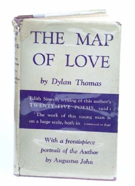
Thomas, Dylan. The Map of Love, first edition, Dent, London 1939. Purple cloth, dustjacket, portrait frontispiece, octavo.

Lot 727

Official Railway Map of London and its Environs - Railway Clearing House, London 1935 (1)

Lot 250

Local Interest: Derek Abel: a signed watercolour of Red Lion Square, Stamford plus a map of Rutland Water (2)

Lot 877

A hand-coloured map of the River Thames, in ebonised frame, together with a gilt framed rectangular wall mirror

Lot 882

Three engravings, views of St Pauls, a coloured map of Lancashire and two other pictures

Lot 352

Le Cours Du Po, a five section map engraved cartouche with figures, flags and armorial trophies by N. Overard, cartographer P. Placide, 1734, 45x245cm.

Lot 110

EARLY FRAMED MAP OF NORFOLK WITH INSET DETAIL OF NORWICH

Lot 90F

Map of Leicestershire, old book of portrait engravings, oval mirror, binoculars, horse brasses etc

Lot 337

A First World War Leather Sam Browne, with pouch stamped Leatheries Ltd, 1917, and a 455 Webley holster, stamped Finnigans Ltd, 1916; a Pair of Steel Rowel Spurs, stamped Birch 1914, with leather straps; a First World War Canvas Map Case, with unusual inverted V shaped leather suspension strap; a Pace Stick, Dress Belt and Stable Belt, to Regimental Sergeant Major Frank Smith of the 15/19 Hussars (7)

Lot 205

One Volume: Two Hundred and Fifty Years of Map Making in the County of Hampshire, 1575-1826, published by Harry Margary, and dated 1976

Lot 209

A MAP OF GLOUCESTERSHIRE, two 'Cries of London', a watercolour of the Park and an oval print

Lot 369

MALTON, James, 'A Picturesque & Descriptive View of the City of Dublin', London, 1794. Cold. Frontis (creased), 19 plates. separate map of Dublin, lge, fo. pp. det. bds worn. Defective (see part illustration)

Lot 382

Berry, William The History of the Island of Guernsey, published London 1815, bound in calf with gilt tooled title to spine, with folding map and 29 plates.

Lot 401

Plees, W. An Account of the Island of Jersey; containing a compendium of it's Ecclesiastical, Civil and Military History: etc. printed by T.Baker 1817, with folding map (torn to edge) and plates (foxing).

Lot 410

Clarke, Louisa Lane Redstone's Royal Guide to Guernsey and Jersey; Or, The Stranger's Companion for the Islands of Guernsey and Jersey, and adjacent Islands, fourth edition, published 1852 by Henry Redstone, Arcade Library, Guernsey and Redstone, 12 Halkett Place, Jersey, with folding map, together with Folk-lore of Guernsey and Sark, by L. Lane-Clarke 1880 with Armorial bookplate for Seymour M.H.Le Marchant, together with a pamphlet Anglo Norman Legends; Or Tales of The Channel Islands (3).

Lot 417

Berry, William The History of the Island of Guernsey, published 1815, with map and plates, original cover with crude repair to spine.

Lot 418

Berry, William The History of the Island of Guernsey, published 1815, rebound copy with gilt title to spine, map absent, plates intact.

Lot 420

Berry, William The History of The Island of Guernsey, published London 1815, bound in calf with gilt tooled title to spine, complete with one hand-coloured map and 29 hand coloured aquatints.

Lot 432

John Speede (1552-1629) A map of Holy Iland, Garnsey, Farne Iland and Jarsey with hand colouring circa 1676. 15 x 20in (38 x 51cm).

Lot 433

A map of The British Channel from Thomson's New General Atlas, 1814. with hand colouring to coastlines, unframed 20 x 25in (51 x 63.5cm).

Lot 434

A William Gardner Guernsey Map surveyed by order of The Duke of Richmond in 1787, in two folding parts, North and South, with original green cardboard slip case, with paper label for James Wild, Geographer to Her Majesty and ink inscription ' Lt. Seymour Le Marchant, 1st Royal Guernsey Militia, November 1872.

Lot 435

John Speede (1552-1629) A map of Holy Iland, Garnsey, Farne Iland and Jarsey with hand colouring circa 1676, glazed to both sides 15 x 20in (38 x 51cm).

Lot 420

After Laurie & Whittle, a map of Roads from Tyburn Turnpike to Tewkesbury, 31cm x 25cm

Lot 432

A 19th Century coloured map, after Bowen of the County of Lancashire, divided into hundreds, 71cm x 54cm

Lot 1806

A group of assorted prints and maps, including A New Map of Hertofrdshire by John Carey 1801, with hand colouring, an etching of Tourelle, another of Old Houses and Stocks, Aldbury by Albany Howarth, a map of the North part of the West Riding of Yorkshire by John Carey and a pair of marine engravings, (6).

Lot 1873

Robert Morden, Map of Hampshire, engraving with hand colouring, 37cm x 42cm.

Lot 1875

Robert Morden, Map of Buckinghamshire, engraving with hand colouring, 42cm x 35cm.; together with maps of West Riding; North Riding and East Riding, Yorkshire. (4)

Lot 1880

Emanuel Bowen, Map of Surrey divided into its hundreds, engraving with hand colouring, 54cm x 72cm.

Lot 430

After H. Moll. Map of Barbados and two other maps of St Lucia and the Gulf of Mexico. Framed.

Lot 1647

John Speed coloured engraving Map of Dorsetshyre 1662 15.5 x 20.5in.

Lot 1648

John Speed (1542-1629) coloured engraving Map of Ilands; Holy, Garnsey, Farne & Iarsey 1662 15 x 20in.

Lot 1665

Johannes Blaeu unframed coloured engraving Map of the South East of England 14.5 x 18in. a Neele map of the Aegean Islands and a Ludovici map Orbis Romani.

Lot 189

A selection of framed and glazed 18th and 19th century coloured engravings depicting views of Surrey, along with a later coloured map of Surrey (9)

Lot 318

SHOBERL, A TOPOGRAPHICAL AND HISTORICAL DESCRIPTION OF THE COUNTY OF SUFFOLK, 1820, half leather bound with marbled boards, Bacon's County MAP OF SUFFOLK and six others. (8).

Lot 431

EMANUEL BOWEN, West Riding of Yorkshire, engraved map with pictorial title panel, View of Leeds and Dedication Cartouche, hand coloured, 22 1/2" x 29", gilt frame.

Lot 432

JOHN OGILSBY, The Road from York to Lancaster, engraved route map with pictorial title panel, hand coloured, 13 3/4" x 17 1/2", oak frame.

Lot 433

JOHN BLAEU, Ila Insula or the Isle of Ila, engraved map with title cartouche, hand coloured, 16" x 20 3/4", Hogarth frame.

Lot 434

JOHN BLAEU, "The North Ridinge of Yorkshire", with figural title cartouche, scale cartouche, and fourteen coats of arms embellished with putti, hand coloured, description of county verso, 14 3/4" x 19 1/4", and a similar map The West Riding or Yorkshire, 16 1/4" x 19 3/4", Hogarth frames (2).

Lot 435

ROBERT MORDEN, The Smaller Islands of the British Ocean, hand coloured map with title cartouche and scale, 14" x 16 1/4", ebonised frame.

Lot 436

EMMANUEL BOWEN, West Riding of Yorkshire, engraved map, hand coloured with pictorial title cartouche, dedication cartouche with coat of arms and scrolls, and View of Leeds, 21" x 28", gilt frame.

Lot 438

JOHN SPEED, Italia, hand coloured map with title cartouche and scale cartouche, border showing vignettes of various Italian cities and costumes, script verso, 15 3/4" x 20 1/2", framed.

Lot 439

JOHN SPEED, Greece, hand coloured map with title cartouche and scale cartouche, inscribed "to be sold by George Humble 1626, script verso, 16" x 21".

Loading...Loading...
  • 109198 item(s)
    /page

Recently Viewed Lots