We found 109198 price guide item(s) matching your search

Refine your search

Year

Filter by Price Range
  • List
  • Grid
  • 109198 item(s)
    /page

Lot 19

JOLLIE F. & SONS. (Pubs).  Cumberland Guide & Directory. 2 vols. in one. 3 fldg. eng. maps & plans & a fldg. eng. plate. Qtr. calf, top brd. det. but present. Carlisle, 1811.Condition report:Whitehaven - Printing crisp, some staining, rips to bottom left hand side and edge folds.Workington - Printing crisp. brown foxing to centre of map. Teat on right hand side.Carlisle - Light staining to bottom right hand corner. Small tear at bottom neat yard scale.Cumberland - Colours crisp and not tears or edge folds. Slight foxing to top.

Lot 230

Plymouth.  Early 19th cent. eng. 1 inch:mile map of the coastal area around Plymouth. (Engraved at the Drawing Room in the Tower by Benj. Baker & assistants); also C. Smith, A New Map of the County of Surrey, col. eng. map (torn at folds), 1808.  (2).

Lot 240

Astronomy.  Pen & ink manuscript map of The Galaxies by Arthur Lang, Planetreeyetts, 21st February 1851. 7½" x 9". Framed. 

Lot 247

PEACOCK E. H.  A Game-Book for Burma & Adjoining Territories. Illus. & fldg. map. Orig. cloth, nice cond. 1st ed., 1933; also Frank N. Streatfeild, Sporting Recollections of an Old'un, illus., orig. cloth, 1913.  (2).

Lot 27

NEWTE THOMAS.  Prospects & Observations on a Tour in England & Scotland, Natural, Oeconomical & Literary. Fldg. eng. map & 23 eng. plates (one noteD as torn). Quarto. Calf, neatly rebacked. Bookplate of Mary Rose Fitzgibbon. 1791.

Lot 37

GREEN WILLIAM.  The Tourist`s New Guide Containing a Description of the Lakes, Mountains and Scenery. 2 vols. Fldg. eng. map, 6 aquatint plates & 8 etched plates. Half calf. Kendal, 1819.

Lot 38

WHELLAN WILLIAM.  The History & Topography of the Counties of Cumberland & Westmorland. Fldg. map. Quarto. Half green morocco, worn internally. Pontefract, 1860; also William Hodgson, Flora Of Cumberland, 1898 & various others, Cumbrian & Northern interest.

Lot 40

CAINE CAESAR.  Capella de Gerardegile or The Story of a Cumberland Chapelry (Garrigill). No. 32 of a small edition. Map, plates & illus. Orig. dark cloth, rather worn. Haltwhistle,1908.

Lot 53

HOUSMAN JOHN.  A Descriptive Tour & Guide to the Lakes, Caves, Mountains ... in Cumberland, Westmorland ... & a Part of the West Riding of Yorkshire. Fldg. eng. frontis, fldg. eng. map, plan of Kendal, plans of the Lakes & 5 other fldg. eng. plates. Paper covered brds. Carlisle, 1814.

Lot 54

BAINES EDWARD.  A Companion to the Lakes. Fldg. eng map, hand col. in outline. Orig. cloth, some mkg. & wear. 1830; also Cooke's Topographical & Statistical Description of the County of Cumberland, fldg. eng. map, 24mo, n.d.  (2).

Lot 55

WORDSWORTH WILLIAM.  A Guide Through the District of the Lakes in the North of England. Fldg. eng. map. Orig. cloth. Inscription of Rev. Austin of Keswick & bookplate of General Aylmer. Kendal, 1835.

Lot 56

(WEST THOMAS).  A Guide to the Lakes in Cumberland, Westmorland & Lancashire. Eng. frontis & eng. fldg. map (poss. added from another ed.). Calf, 1780.

Lot 58

OTLEY JONATHAN.  A Concise Description of the English Lakes & Mountains. Fldg. eng. map & other illus. Orig. green cloth. Keswick, 1834; also Hudson Scott, A Guide to the Lakes ... with a Sketch of Carlisle, double page map, Carlisle, n.d.  (2).

Lot 62

(WEST THOMAS).  A Guide to the Lakes in Cumberland, Westmorland & Lancashire. Eng. frontis, eng. fldg. map & eng. plate. Qtr. calf, some wear & splitting. 1793; also Tattersall, The Lakes of England, fldg. map & plates, green cloth, c.1836.  (2).

Lot 64

LEIGH & SON. (Pubs).  Guides to the Lakes & Mountains of Cumberland, Westmorland & Lancashire. With a loose fldg. eng. map & other maps bound in, all hand coloured. Orig. cloth with label, tending to split. 1835; also Ford's Guide to the Lakes, Carlisle, 1840.  (2).

Lot 787

John Speed - County map of Staffordshire, Sudbury and Humble, hand-coloured, 38.5cm x 51cm, framed

Lot 245

A WW2 silk escape map of France. Provenance: Submitted by Mrs. Lauraine Sadleir MBE & the late Mr. Michael R. Sadleir

Lot 299

A WW2 US army metal water bottle, a British army tent oil lamp, a ministry of fuel & power aluminium hand torch & an early 20thC. cigarette case in Indian silver depicting engraved map of India one side & Taj Mahal on other. Provenance: Submitted by Mrs. Lauraine Sadleir MBE & the late Mr. Michael R. Sadleir

Lot 1424

SAXTON (CHRISTOPHER) AND SPEEDE (JOHN), WORCESTERSHIRE, hand-coloured engraved map, framed. 39.5cm by 52cm

Lot 1425

SPEEDE (JOHN), NORTHAMTONSHIRE, hand-coloured engraved map, framed. 41.5cm by 53.5cm

Lot 423

Maps and other War Office issue British Expeditionary Force documents issued to Lt.-Col C.W. Tribe. Four linen-backed maps in good condition: Belgium - Antwerp Sheet 3 (1:100,000) Belgium - Brussels Sheet 6 (1:100,000) France  - Montreuil Sheet 6 (1:80,000) N.W. Europe - Sheet 1 (1:250,000)Together with:Another, smaller, paper War Office map of Dunkirk: France - Dunkerque - Sheet 2 (1:80,000) marked in crayon 'Tribe'Standing Orders for the Expeditionary Force by Field Marshall French (Southampton 9th August 1914)Composition of Army Corps and Cavalry Divisions of the French Active Army (1914)The Egyptian State Railways (Nov. 1 1915 - April 30 1916) Horaire de Poche (pocket timetable) with pull-out maps of Upper and Lower Egypt annotated in pencil with embarkation notes and Mrs C. F. Nixon's address at 62 St. Michaels Road, Bedford ( both her husband, Capt. Nixon, and Col. Tribe were severely wounded, almost simultaneously, in the Dogras' assault on the German trenches at La Tourelle on May 9th 1915. Nixon was severely wounded again in Mesopotamia on Jan 13th 1916 and Colonel Tribe killed two hours later whilst 'as at Shikh Saad ... leading the advance with great dash, exposing himself in the most gallant manner' ). (The corner of p9 folded to bookmark the Dogra's journey from Port Said to Kantara.)

Lot 506

A framed and glazed hand-coloured map engraving FifAE Vicecomitatvs (the Sherifdome of Fife) probably 17th/18th century (39cm x 49.5cm)

Lot 556

An early 19th century Newton's Pocket Terrestrial Globe (marked 'Newton's New & Improved Terrestrial Pocket Globe No 66 Chancery Lane, London') with incremented brass axis, the 7.5cm diameter globe also marked 'NB. the improved Analemma is intended to supersede the necessity the ecliptic line hitherto unnecessarily drawn upon the Terrestrial Globe PUB. JA.1.1. 1817', with an original fitted shagreen spherical case revealing 12 hand-coloured engraving gores to papier-mâché sphere displaying celestial map to the top half (the shagreen case 9.25cm diameter)The condition is very good both inside and the exterior.

Lot 764

A late 19th century hardbound hand-coloured Atlas, 'Walker's British Atlas, To Her Most Excellent Majesty Queen Victoria and to Her Royal Highness the Duchess of Kent,  this British Atlas comprising separate maps of every county in Scotland and Riding in Yorkshire and North and South Wales showing the roads, railways, canals, parks, boundaries of Boroughs and compiled with the maps of the Board of Ordinance and other Trigonometrical surveys is, with their gracious permission most respectfully dedicated by a very humble and devoted servants J & C Walker', Published by Longman 1874 and with a multitude of coloured map plates etc. within (37.75cm high)

Lot 7015

Theodore Roosevelt: 'African Game Trails: An Account of the African Wanderings of an American Hunter-Naturalist', London, John Murray, November 1910 reprint, 49 plates (mainly from photographs) + map as called for, handsomely rebound half burgundy morocco gilt, spine gilt in compartments

Lot 7043

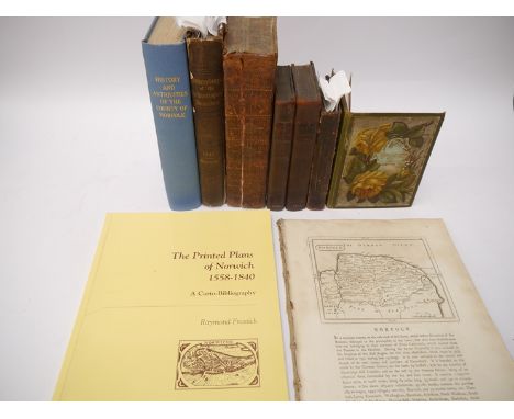
A collection of Nineteen Norfolk Broads and Norfolk/North Suffolk related titles, including Arthur Henry Patterson: 'Man and Nature on the Broads', [1895], 1st edition, illustrated throughout, 143pp, 4to, original pictorial cloth gilt and silvered; plus Payne Jennings: 'Sun Pictures of the Norfolk Broads', 1892, 2nd edition, illustrations from photographs throughout, original pictorial cloth gilt; plus Ernest Suffling: 'The Land of the Broads', circa 1887, 20th thousand, folding map (with tear i.e. in two parts, but complete), illustrations throughout, original pictorial cloth gilt; plus facsimiles of Blake's Yachting List catalogues 1908 and 1916, each limited editions (numbered 556 & 479 of 2000 respectively), each oblong, original wraps, in original card slipcases; plus 'Twelve Colour Pictures of Lowestoft', souvenir view album circa 1900 published by Jarrold and Sons, 12 coloured plates as called for, oblong 4to, original cloth backed boards; plus Longe: 'Lowestoft in Olden Times', Lowestoft, McGregor & Fraser, 1905, 2nd edition, frontis, original pictorial wraps; plus Eric Pursehouse: 'Waveney Valley Studies', Diss, Diss Publishing Co, circa 1965, original printed wraps; plus Chambers: 'A Corner of Suffolk', Lowestoft, Flood & Son, 1926, frontis, original printed paper covered boards; plus 10 others including Dutt, M.R. James, Fendall 'A Norfolk Anthology' 1972 1st; 'The Norfolk Broads Holiday Book and Pocket Pilot' 1952 1st, plus a 19th Century souvenir view album 'The Royal Cabinet Album of Sea Side', London, Rock & Co., 24 humourous views on 12 folding concertina leaves, original decoraive cloth gilt, etc. (19)

Lot 7049

William White: 'History, Gazetteer and Directory of Norfolk', Sheffield, 1836, 1st edition, map not present as usual, comptemporaary calf board,s later sympathetically rebacked calf gilt

Lot 7055

Joannis Battely [John Battely]: 'pera posthuma : Viz : Antiquitates Rutupinae et Antiquitates S. Edmundi Burgi, ad annum 1272 perductae', Oxoniae, 1745, 2nd edition, 2 works bound in 1, 16 engraved plates + 4 vignettes as called for, 4to, contemporary calf, later rebacked; plus Samuel Tymms, 2 titles: 'An Architectural & Historical Account of the Church of St. Mary, Bury St Edmunds', 1854, 1st edition, 20 illustrations as called for, old calf worn, 'Tymms handbook of Bury St Edmunds', 1885, 5th edition, a/f, lacks map + index pages 121/122, original cloth gilt (worn, inner joints split); plus 'A concise description of Bury St. Edmund's : and its environs, within the distance of ten miles / illustrated by engravings and woodcuts of upwards of forty churches', London, 1827, 25 full page engraved plates (many with 2 engraved ills to a page), old cloth backed boards; plus Edmund Gillingwater: 'An Historical Account of St Edmund's Bury', 1804, no title page, pp163-311, old half calf gilt, ex library, bookplate and ownership signature/inscription of Thomas Tindal Methold; plus 1 other Bury St Edmunds related (6)

Lot 7065

Edmund Bartell: 'Cromer, considered as a watering place : with observations on the picturesque scenery in its neighbourhood', London, 1806, 2nd edition much enlarged, hand coloured engraved folding map + 2 aquatint plates as called for, contemporary half calf gilt, spine gilt in compartments

Lot 7089

Major J.H. Leslie: 'The History of Landguard Fort, in Suffolk', London, 1898, 1st edition, map frontis + 25 plates as called for, original cloth gilt; plus '32 views of Felixstowe and District', published Callcut & Beavis, circa 1900, view album, 32 views on folding concertina leaves, oblong (17 x 24cm), original cloth gilt (2)

Lot 7090

Thomas Gardner: 'An Historical Account of Dunwich, Antiently a City, now a Borough; Blithburgh, formerly a Town of Note, now a Village; Southwold, once a Village, now a Town-Corporate', London, 1754, 1st edition, 3 engraved plates (lacks the prosepct and map), 4to, contemporary half calf, later calf rebacked retaining contemporary leather gilt title label, Claude Morley (1874-1951, antiquary of Monk Soham House, Woodbridge) pencil ownership signature verso FFEP; plus [Edward Clodd]: 'A Guide to Aldeburgh', ALdeburgh, J. Buck, 1861, lacks the plates by Rock Brothers but scarce nonetheless, v,114,[1]pp, original cloth gilt (worn), end papers replenished; plus A.E. Murton: 'Gillingwater's History of Lowestoft', 1897, original cloth gilt; plus 'Orford Ness. A Selection of Maps mainly by John Norden', Cambridge, Heffer, 1966, 1st edition, 22 maps as called for, original two tone cloth gilt (4)

Lot 7125

John Speed, engraved hand coloured map of Suffolk, [1611], "George Huble [Humble]", inset town plan of Ipswich, trimmed to strapwork margins on verical borders, central fold strengthened verso, residue to central fold recto, approx 38 x 51cm, English text verso, unframed/unmounted

Lot 7131

A packet of 5 Norfolk sale particulars, including Ludham, Potter Heigham and Catfield large booklet of 3 sale particulars in 1, 1914, comprising "High House", Ludham, "Bower Farm", Potter Heigham & "Walton Hall Farm", Catfield, 2 plans + 1 plate from a photograph, original printed wraps; plus Plumstead and Salhouse, 1899, with large folding map, original printed wraps; East Bradenham, Scarning & Shipdham, 1920; Dickleburgh, 1963; 17 Rampant Horse Street, Norwich, 1938 (5)

Lot 7139

Frank Brown: 'Frost's Drawings of Ipswich and Sketches in Suffolk', Ipswich, published by the author, 1895, limited edition signed and numbered (50/105), frontis + map + 26 plates as called for, folio, original cloth backed decorative woven silk covered boards (very worn and frayed), surplus quantity of original decorative woven green silk loosely inserted

Lot 7146

Ten Suffolk related titles including JJ Raven: 'The Church Bells of Suffolk', 1890, limited edition (106/500), numbered, copy given by JJR to William and Edith Raven-Hart and ex-libris bookplate of Stephen Govier [working copy], original cloth gilt (worn), crudely rabacked; plus Hill: 'Echoes from the past life of Burgate'; 'Suffolk in the XVIIth Century. The Breviary of Suffolk by Robert Reyce 1618. Notes by Lord Francis Hervey', 1902, original quarter vellum; plus Vincent B. Redstone: 'Memorials of Old Suffolk', 1908, original cloth gilt, top edge gilt; Powell: 'A Suffolk Hundred in the Year 1283', 1910; plus 2 bound 17th and 18th Century extracts on Suffolk including Suffolk text from Blome's map, 1673, each rebound cloth; plus Saward 'Firefighting in Suffolk', 2 volumes; plus ne other similar (10)

Lot 7148

Nine Norwich and Norfolk related titles, including 'Recollections of Norwich', Rock & company, circa 1864, 24 photo-litho views on folding concertina leaves, including Burnham Thorpe Rectory and Blickling Hall etc, original cloth with pictorial title label gilt to top board (15 x 12cm); plus Francis Grose: 'Antiquities of England and Wales', circa 1784, Norfolk extract from volume IV, [4],26pp, engraved map + 13 engraved plates including Castleacre, Caister Castle, Norwich Castle, Thetford Priory etc; plus Raymond Frostick: 'The Printed Plans of Norwich 1558-1840', original wraps; plus G.A. Cooke: 'A Topographical and Statistical Description of the County of Norfolk...Suffolk', 1822, 2 volumes in 1, with engraved views of Norwich, Yarmouth, Thetford, Wolterton Hall, Castle Rising Castle and a hand coloured map of Norfolk. Suffolk an engraved view of Wolsey's Gate Ipswich, Framlingham Castle, Woodbridge, Blythburgh Church and Mettingham Castle, contemporary half calf (worn); plus 'History of Norfolk, or Excursions in the County', 1825, 2 volumes, with upwards of 100 engravings by John Sell Cotman and others, contemporary calf, rebacked (not recent); plus Evans & Britton: 'The Beauties of England and Wales Volume XI Norfolk, Northamptonshire, Monmouthshire', 1810, numerous engraved plates including several various Norfolk Halls, Churches etc, contemporary calf gilt worn, backstrip/textblock split; plus [Mostyn John Armstrong]: 'History and Antiquities of the County of Norfolk Vol VII - Happing, Henstead, Holt, Humbleyard and Loddon', 1781, rebound cloth gilt; plus 1 other similar (9)

Lot 7149

Six Norfolk interest titles including Martin: 'The History of Thetford', 1779, lacks title page and port frontis, 9 other engraved plates present, copy of R. Manby of Thetford, 4to, contemporary calf worn, top board detached but present, "R. Manby" in gilt to top board; Lubbock: 'Observations on the Fauna of Norfolk', 1879, new edition, large folding map, original cloth gilt; Bloom: 'Notices of the Castle and Priory at Castleacre', 1843, as found working copy; Walter Rye: 'Cromer Past and Present', 1889, limited edition (12/500), numbered, crown 4to, original half calf gilt, top board/spine crudely reinforced with tape externally; plus Wortley: 'Downham Market', original cloth gilt; plus Steers: 'Scolt Head Island', 1934, large folding map + numerous other folding plates etc, original cloth gilt (VGC), scarce in good condition (6)

Lot 7156

C. & J. Greenwood: 'Map of the County of Essex, from an Actual Survey Made in the Year 1824', London, Greenwood, Pringle & Co., 1825, large engraved hand coloured folding map, dissected and backed onto linen, large engraved vignette of Audley End House, 42 sections, approx size 132 x 157cm, generally clean and VGC

Lot 7157

Michael Drayton: 'Parte of Suffolk. Essex', scarce engraved map, [1622], professionally repaired/restored at centrefold, approx. 25 x 32cm

Lot 7160

John Speed: 'Norfolk', engraved hand coloured map, circa 1631, trimmed at margins (close trimmed at left hand margin), hand colouring dark, repaired at centrefold verso

Lot 7161

Gerard Mercator: 'Eboracum, Lincolnia, Derbia, Staffordia, Nottinghamia, Lecestria, Rutlandia et Norfolcia', engraved hand coloured map depicting East England from Yorkshire to Norfolk, circa 1595

Lot 7162

London. John Rocque. [An Exact Survey of the citys of London Westminster ye Borough of Southwark and the Country near ten miles round, begun in 1741 & ended in 1745 by John Rocque Land Surveyor ; & Engrav'd by Richard Parr.], circa 1746, one map sheet (only) from Rocque's multi sheet large scale map of London, this sheet depicting Walthamstow, Wanstead, Leyton, Hackney Marsh area. VGC, good margins

Lot 7163

Henricus Hondius: 'A General Plott of the Fennes and Surounded grounds in the sixe counties of Norfolke, Suffolke, Cambridge, with in the Isle of Ely, Huntington, Northampton and Lincolne etc.', Amsterdam, 1632 [or later],engraved map of The Fens, Latin text verso

Lot 7164

Emanuel Bowen: 'An Accurate Map of the East Riding of York Shire divided into its Wapontakes &c...', engraved map, circa 1765, published C & J Bowles and Robt. Sayer; plus Richard Blome: 'A Mapp of East Rideing of Yorkshire', engraved hand coloured map, circa 1673; plus small format maps 'Map of the East Riding of Yorkshire', by T. Osborne, 1748 and 'Yorkshire', by John Seller, circa 1703 (4)

Lot 7165

John Chapman & Peter Andre: 'A map of the county of Essex, From an Actual Survey made in MDCCLXXII, MDCCLXXIII & MDCCLXXIV', engraved hand coloured map, circa 1777, sheet XVI only, showing area of Woodford, Loughton, Theydon, Waltham Forest, Hainault Forest, Walthamstow, Waltham Holy Cross, Ongar Park Wood, Romford etc, printed area approx. 48 x 58cm; plus Robert Whitworth: 'Plan of the Intended Navigable Canal from Moor Fields into the River Lee at Waltham Abbey', circa 1773, app size 13.5 x 51cm (2)

Lot 7166

Robert Morden: 'Norfolk', engraved hand coloured map, circa 1695, close trimmed at margins; plus Haywood/Sudlow 'A Map of Norfolk', engraved map, 1789; plus smaller format Morden map of Norfolk and smaller format Kitchin map of Norfolk 1748, plus 19th Century Moule map of Norfolk (5)

Lot 7168

Haywood/Sudlow: 'A New Accurate & Correct Map of Essex', engraved hand coloured map, 1787; plus Owen/Bowen early 19th Century hand coloured small format map of Essex; plus one other similar (3)

Lot 7169

John Stockdale: 'Great Britain and Ireland with ye Judges Circuits', engraved map, 1805, inset maps of the Shetland Islands and The Hebrides. Large triangular distance chart titled "Distances of the Cities & Shire Towns in England & Wales"; Paul de Rapin-Thoyras: 'A Correct Chart of the Geman Ocean', engraved hand coloured map/chart, circa 1744; plus 17th/18th Century chart of River Severn/Mouth of River Avon; plus Edwards: 'Map of the Island of St Vincent', 1794 (4)

Lot 7170

Johannes Blaeu: 'Bedfordshire and Buckinghamshire', engraved hand coloured map, circa 1650

Lot 7171

John Speed: 'Essex', engraved map, [1611], "solde by G. Humble", inset town plan of Colchester

Lot 7172

Johannes Blaeu: 'Cornwall', engraved hand coloured map, circa 1645, plus H. Moll: 'Somerset', ngraved map, circa 1720 (2)

Lot 7173

Johannes Blaeu: 'The Bishoprike of Durham', engraved hand coloured map, circa 1645

Lot 7175

Johannes Blaeu: 'Berkshire', engraved hand coloured map, circa 1645

Lot 7176

Johannes Blaeu: 'Cambridgeshire', engraved hand coloured map, circa 1645

Lot 7177

Johannes Blaeu: 'Oxfordshire', engraved hand coloured map, circa 1645

Lot 7178

John Speed: 'Europ, and the cheife Cities contaned therin, described; with the habits of most Kingdoms now in use [Europe]', engraved map, circa 1626, "Are to be sould in popes-ead alley, against the Exchange, by George Humble", borders with figures in national costume and city views, English text verso

Lot 7179

John Speed: 'Barkshire Described [Berkshire]', engraved map, circa 1611, "I. Sud and Georg Humble", panorama of Windsor Castle, English text verso

Lot 7180

Christopher Saxton/William Hole: 'Buckinghamshire', engraved map, circa 1610

Lot 7181

John Speed: 'Bedfordshire and the situation of Bedford described', engraved map, circa 1611, "George Humbel", inset town plan of Bedford, English text verso

Lot 7182

Philip Lea: 'Oxford, Buckingham and Berkshire', engraved hand coloured map, circa 1720, inset plan of Oxford

Loading...Loading...
  • 109198 item(s)
    /page

Recently Viewed Lots