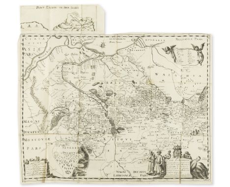

Ukraine.- Beauplan (Guillaume Levasseur, Sieur de) Description d'Ukranie, qui sont plusieurs provinces du Royaume de Pologne. Contenuës depuis les confins de la Moscovie, jusques aux limites de la Transilvanie, small woodcut ornament to title, large folding engraved map with extension piece at head, 2 woodcut plates, woodcut illustrations in text, woodcut head-pieces and decorative initials, some pencil underlining and passage marking, map with a few small splits at folds, and some light staining and creasing, occasional spotting, contemporary limp vellum, spine with later gilt, stamped black foliage decoration and a black morocco label, nick to spine near head, lightly soiled, edges stained red, small 4to, Rouen, Jacques Cailloüé, 1660.⁂ Rare. Beauplan was a French-Polish cartographer, engineer and architect. In 1639 he created the first descriptive map of Ukraine. The present work, first published under the title Description des contrés du Royaume de Pologne in 1651, gives a geographical, economic, and demographic description of Ukraine.
We found 109198 price guide item(s) matching your search
There are 109198 lots that match your search criteria. Subscribe now to get instant access to the full price guide service.
Click here to subscribe- List
- Grid
-
109198 item(s)/page
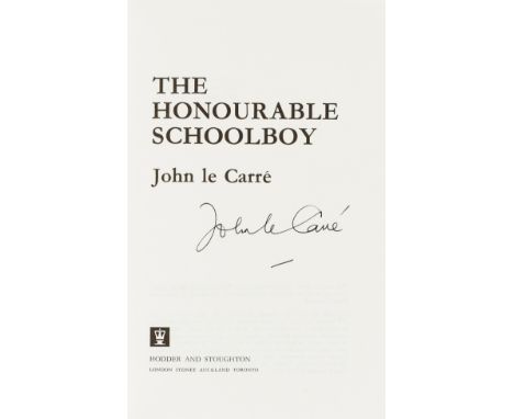
Le Carré (John) The Honourable Schoolboy, first edition, signed by the author on title, plain endpapers, original boards, light bumping to spine ends, dust-jacket, price-clipped, some rubbing and light creasing to head and foot, near-fine otherwise, 8vo, 1977.⁂ The second title in the Karla trilogy. There are two issues with either map or plain endpapers, seemingly without any established primacy.

Bible, Dutch.- Biblia, Dat is De gantsche H. Schrifture vervattende alle de Canonijcke Boecken des Ouden en des Nieuwen Testaments, 4 parts in 1, engraved pictorial title, double-page world map by N. Visscher and 5 double-page maps and plans of the Holy Land, woodcut historiated and decorative initials, engraved title trimmed to border and laid down, maps and plans lightly browned and with a little staining, marginal water-staining at head, occasional spotting and staining, lightly browned, late 18th / early 19th century green morocco-backed burgundy morocco, ?later metal centre- and corner-pieces, rubbed, a solid copy, folio, Dordrecht, [Printed by Jacob Braat] for Ian Barentsen Smient & Helmich van Cappel, 1662.
![[Hanway (Jonas)] A Journal of Eight Days Journey from Portsmouth to Kingston upon Thames; through Southampton, Wiltshire, &am](https://cdn.globalauctionplatform.com/a0988b56-ce15-46f3-a774-ad9e00bb6358/158f162e-84ca-4d7a-a1cd-ad9e00dbdf47/468x382.jpg)
[Hanway (Jonas)] A Journal of Eight Days Journey from Portsmouth to Kingston upon Thames; through Southampton, Wiltshire, &c...To which is added, An Essay on Tea, 2 vol., second edition, engraved folding frontispieces, occasional foxing or light soiling, modern crushed morocco, H. Woodfall & C. Henderson, 1757 § Pugh (John) Remarkable Occurrences in the Life of Jonas Hanway, first edition, folding engraved map, occasional spotting, modern calf, for the Author, 1787; and 4 others, 8vo (7)
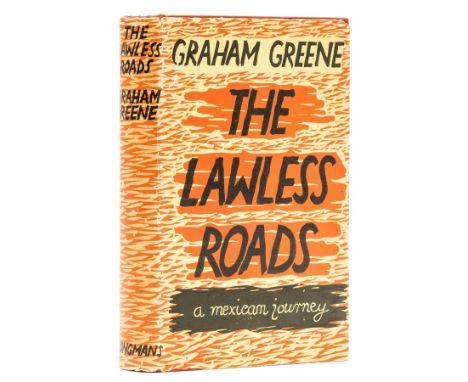
Greene (Graham) The Lawless Roads, first edition, first issue with yellow map endpapers, photographic illustrations tinted blue, the spine lettered in gilt and top edge stained yellow, photographic plates, neat contemporary ink ownership inscription to endpaper, original cloth, spine a little darkened, light surface soiling to covers, spine ends a little bumped, dust-jacket, price-clipped, light toning to spine, 2 small puncture marks, spine ends and corners a little chipped, some splitting to upper fore-edge, a few small surface abrasions, but a very good example overall, preserved in custom slip-case, 8vo, 1939.⁂ The rare first issue with a number of differences in the production between this and the second issue (see next lot). The Lawless Roads is Greene's account of his 1938 trip to Mexico, a visit that would also provide the basis for The Power and the Glory.
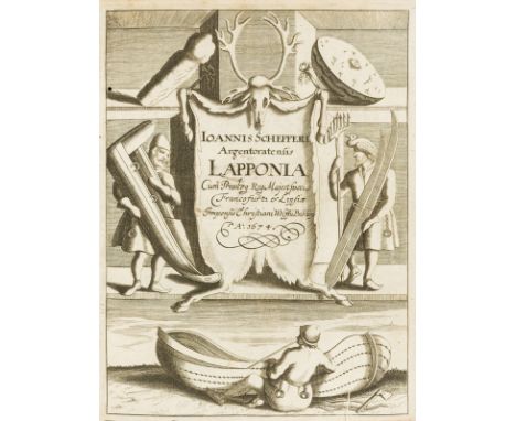
Lapland.- Schefferus (Joannes) Lapponia id est regionis Lapponum et gentis nova et verissima descriptio, first edition, engraved additional pictorial title (dated 1674), printed title in red and black and with woodcut vignette, folding engraved map, woodcut illustrations in text, some full-page, errata f. at end, some underlining and passage marking in brown or ordinary pencil, single small wormhole to inner gutter of around first half of the work, little offsetting to map, foxing, occasional staining, lightly browned, later vellum, flat gilt spine in compartments and with black stamped floral motifs and a black leather label, yapp edges, little marked and stained, small 4to, Frankfurt, Johann Andreae for Christian Wolff, 1673.⁂ First edition of the first comprehensive study of the Sami people, and for long the most important source of information on Lapland and its inhabitants.
![Classics.- Caesar (Gaius Julius) [Opera] quae exstant, engraved pictorial title, folding map and full-page illustrations, som](https://cdn.globalauctionplatform.com/a0988b56-ce15-46f3-a774-ad9e00bb6358/66c2ae77-9e09-4875-b374-ad9e00dada2f/468x382.jpg)
Classics.- Caesar (Gaius Julius) [Opera] quae exstant, engraved pictorial title, folding map and full-page illustrations, some ink staining, occasional spotting, Amsterdam, House of Elzevier, 1670 § Plinius Secundus (Gaius) Epistolæ et Panegyricus, engraved vignette to title, lacking initial and final blanks, occasional spotting and light staining, [Wing P2578], Oxford, Sheldonian, 1687, contemporary calf, the first mentioned armorial, rebacked in later red morocco, gilt, spines in compartments, some with floral motif, some fading, rubbed; and 15 others, Classics, similarly bound, 8vo (17)
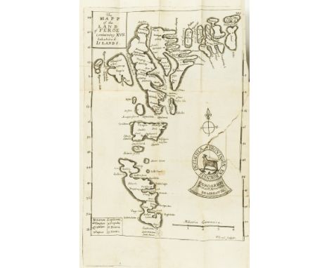
Faroe Islands.- Debes (Lucas Jacobsen) Faeroae, & Foeroareserata: that is A Description of the Islands & Inhabitants of Foeroe, translated by John Sterpin, first edition in English, folding map (torn), lacks folding plate of whirlpool, contemporary gilt panelled morocco, rebacked in later calf, gilt, g.e., [Wing D511], 12mo, printed by F.L. for William Iles, at the Flower-de-Luce in Little-Brittain, over against St. Bartholomews Gate, 1676; sold not subject to return.


18th Century Tokens, LONDON, Cheapside, John Ching, Halfpenny, 9.11g/6h (DH 282), Chiswell Street, Robert Heslop, Halfpenny, 7.65g/5h (DH 336b), Finsbury Square, Lackington, Allen & Co, Halfpenny, 8.94g/6h (DH 356), Newgate Street, Daniel Eaton, Halfpenny, 1795, 9.46g/6h (DH 301), Russell Court, Sim, Halfpenny, 9.66g/6h (DH 478a); SURREY, Croydon, Daniel Garraway, Halfpenny, 1797, 7.19g/12h (DH 8); Mainwaring’s ‘Map of France’ Halfpenny, 1794, 10.97g/6h (DH 1017f); Uncertain manufacturers, Tom Tackle Halfpenny, 7.49g/12h (DH 1048) [8]. DH 301 extremely fine, others very fine and better £120-£150


Banksy (British 1974-), 'Pieces of mixed ephemera from Dismaland': 1 Banksy official Cinderella Blank in genuine Dismaland gold holder with Castle logo 1 Dismaland Souvenir Book 1 Dismaland program / map 1 Dismaland poster 1 James Cauty Model Village program 1 banksy bling- Black Cross necklace 1 banksy cardboard fish finger in bag 1 Shrigley ping pong ball with good luck written by artist 1 shrigley wrist band 1 shrigley badge - strive for excellence 1 I am an imbecile balloon with black string 1 wsm local paper from opening day 1 official mini Mercury front page poster 1 official large format Mercury front page poster 1 banksy Napalm postcard 1 banksy Wsm postcard 2 ear buds from St Joan's Ambulance (unused) 1 Banksy Dismaland Rat Juxtapose Magazine 1 palestinian artist postcard sized sticker - signed Various business cards and flyers including pocket money loans, adspace hackpack flyers & legal advice cards 1 bored of art balloon with white ribbon ARR


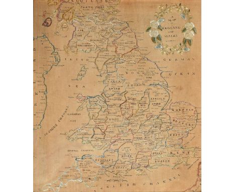
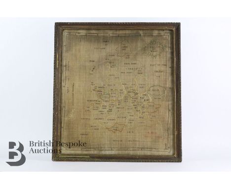
A Regency linen map sampler of England and Wales, c1800, with islands and many of the principal towns identified in black silk, the title framed by a garland of roses, morning glory and other flowers, 50 x 44cm, mahogany frame Provenance: Heathcote Ball & Co, October 19, 1995, £201 Slightly stained and browned but not frayed or holed

Throsby (John) - The Memoirs of the Town and County of Leicester Displayed under an Epitome of the Reign of each Sovereign’, 6 vols in 3, 16mo, map and plates, several folding, later half calf with red labels by Raithby, Lawrence & Co Ltd, first few leaves of vol 1 soiled and stained, title p with loss at top, teg, 1777 (3)


A rare map sampler made to teach writing, needlework and basic geography of counties of England, c1780-1820. This example was made by M. G. Lee of Sutton Coldfield. The map has grid references for longitude and latitude. Usually cross stitch and rectangular as they were made to put on display and were made with silk thread on linen. Approx. h59cm x w54cm.

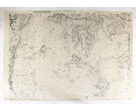
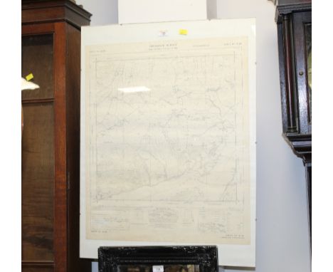
ORDNANCE SURVEY MAP. An Ordnance Survey Map of Trethosa Downs showing extensive mining activities. This map is the 1932 revision, printed at the Ordnance Survey Office, Southampton 1934. 101 x 68cm. Please note that all items in this auction are previously owned & are offered on behalf of private vendors. If detail on condition is required on any lot(s) PLEASE ASK FOR A CONDITION REPORT BEFORE BIDDING. The absence of a condition report does not imply the lot is perfect.WE CAN SHIP THIS LOT, but NOT if part of a large, multiple lots purchase

ANTIQUE MAP. An antique map of the Isles of Scilly c.1700, 'Humbly dedicated and presented by Capt. Greenvile Collins Hydrographer to the King, 1686'. In the top corner, the coastline of Cornwall showing the Lizard, Market Jew, Land's End & Cape Cornwall. Please note that all items in this auction are previously owned & are offered on behalf of private vendors. If detail on condition is required on any lot(s) PLEASE ASK FOR A CONDITION REPORT BEFORE BIDDING. The absence of a condition report does not imply the lot is perfect.WE CAN SHIP THIS LOT, but NOT if part of a large, multiple lots purchase.
PRINTS & ENGRAVINGS ETC. Various engravings of Penzance & other Cornish locations, mostly book plates etc. one framed. Also, a hand coloured print after Kate Greenaway, 'Preparing for Christmas' & two 19th century Geography Bewitched!, Map of England & Wales & Map of Scotland printed for Bowles & Carver 1797. Please note that all items in this auction are previously owned & are offered on behalf of private vendors. If detail on condition is required on any lot(s) PLEASE ASK FOR A CONDITION REPORT BEFORE BIDDING. The absence of a condition report does not imply the lot is perfect.WE CAN SHIP THIS LOT, but NOT if part of a large, multiple lots purchase
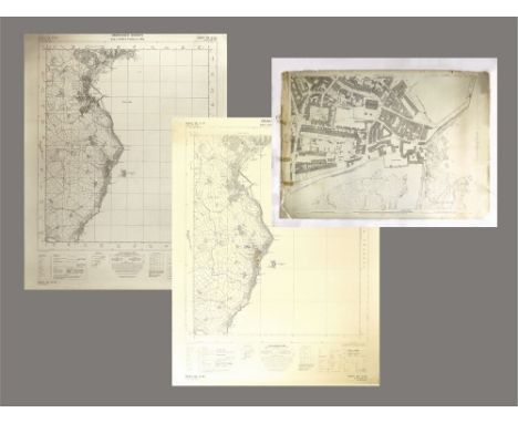
PENZANCE MAP ETC. An Ordnance Survey Map of Penzance Harbour & its surroundings, showing many buildings & numerous courts that have disappeared or been infilled. Surveyed in 1877. 107 x 71cm. Also, two copies of a 1931 map of Penzance Bay showing the coast from Marazion to Lamorna Cove. (one copy stained & torn) Please note that all items in this auction are previously owned & are offered on behalf of private vendors. If detail on condition is required on any lot(s) PLEASE ASK FOR A CONDITION REPORT BEFORE BIDDING. The absence of a condition report does not imply the lot is perfect.WE CAN SHIP THIS LOT, but NOT if part of a large, multiple lots purchase

KELLY'S DIRECTORY. A 1928 Kelly's Directory of Cheshire, complete with folding map. (Fair condition. Map dog-eared, cloth on spine beginning to wear). Please note that all items in this auction are previously owned & are offered on behalf of private vendors. If detail on condition is required on any lot(s) PLEASE ASK FOR A CONDITION REPORT BEFORE BIDDING. The absence of a condition report does not imply the lot is perfect.WE CAN SHIP THIS LOT, but NOT if part of a large, multiple lots purchase.

ENGRAVING & MAP. An engraving of St. Michael's Mount, 19 x 30cm. Also, a John Speede map of 'The Countye of Monmouth', c.1610. 39 x 52cm. (map with discolouration & some staining) Please note that all items in this auction are previously owned & are offered on behalf of private vendors. If detail on condition is required on any lot(s) PLEASE ASK FOR A CONDITION REPORT BEFORE BIDDING. The absence of a condition report does not imply the lot is perfect.WE CANNOT SHIP THIS LOT due to fragility, size or weight. Our recommended carrier is MBE Plymouth on +44 (0) 1752 257224 or info@mbeplymouth.co.uk

MAP OF DEVON. An original 17th century framed 'Mapp (sic) of Devon Shire' by Richard Blome. 25.5 x 31.5cm. Please note that all items in this auction are previously owned & are offered on behalf of private vendors. If detail on condition is required on any lot(s) PLEASE ASK FOR A CONDITION REPORT BEFORE BIDDING. The absence of a condition report does not imply the lot is perfect.WE CAN SHIP THIS LOT, but NOT if part of a large, multiple lots purchase.

MAP PRINTS. Ten printed copies of a fantasy map created & drawn by Roland Morris 'A Mapp of the Cornish Island of W. Penwith'. Unframed. Provenance: Ex-Roland Morris collection, purchased at the clearance auction of Roland Morris Museum of Nautical Art', Penzance. Please note that all items in this auction are previously owned & are offered on behalf of private vendors. If detail on condition is required on any lot(s) PLEASE ASK FOR A CONDITION REPORT BEFORE BIDDING. The absence of a condition report does not imply the lot is perfect.WE CAN SHIP THIS LOT, but NOT if part of a large, multiple lots purchase

BOTALLACK MINE. A 19th century hand drawn & coloured map of Botallack Mine workings. 57 x 75cm. Please note that all items in this auction are previously owned & are offered on behalf of private vendors. If detail on condition is required on any lot(s) PLEASE ASK FOR A CONDITION REPORT BEFORE BIDDING. The absence of a condition report does not imply the lot is perfect.WE CAN SHIP THIS LOT, but NOT if part of a large, multiple lots purchase

ORDNANCE SURVEY MAPS. An Ordnance Survey map of the Truro area, Revision dated 1933. 57 x 42cm. Also, two other maps, one of Penzance dated 1982, the other of Truro & Falmouth dated 1984. Please note that all items in this auction are previously owned & are offered on behalf of private vendors. If detail on condition is required on any lot(s) PLEASE ASK FOR A CONDITION REPORT BEFORE BIDDING. The absence of a condition report does not imply the lot is perfect.WE CAN SHIP THIS LOT, but NOT if part of a large, multiple lots purchase


-
109198 item(s)/page