We found 109182 price guide item(s) matching your search
There are 109182 lots that match your search criteria. Subscribe now to get instant access to the full price guide service.
Click here to subscribe- List
- Grid
-
109182 item(s)/page


Lot 283
King & Country “Club Special” soldiers. 1998 issue – Seaforth Drummer (98SD). 2x 1999 issue - Seaforth Piper (PD SFP). 1999 issue 7 – Victorian Sailor with Tankard (VS1). 2x 2000 issue – Seaforth Drum Major (PD SFDM). Plus a 2001 issue- Afrika Korps Officer (01MIL) with Luger and map. All boxed, with packing, minor wear. Contents Mint. See internet


Lot 342
King & Country Montgomery’s 8th Army “Matilda Tank” (EA07). A heavy British tank in sand, olive green and pale blue camouflage livery, with two man crew, driver and commander with mike in hand, plus standing Sergeant holding map. Boxed, some wear to outer and inner packing. Contents Mint. Plate 3

Lot 346
2 King & Country “8th Army” sets. The Mine Sweepers (EA13). Comprising Officer with map and machine gun, soldier minesweeping and soldier crouching down holding mine. Plus 2 German Minefield signs. Plus 8th Army Tank Riders (EA30). 3 soldiers in seated/kneeling positions with rifle and machine gun. Both boxed with packing. Contents Mint.(8) Plate 3
Lot 649
An altimeter, in the form of a large pocket watch, 2¾” diameter, by J Hicks, 8, 9 & 10 Hatton Garden, London, the lacquered brass case bearing broad arrow mark, contained in 1917 dated leather compass case; a 1917 dated military stop watch, by Mayer & Weill (not working); a 1915 dated compass in pocket watch type case, bearing broad arrow, by Short & Mason Ltd, London; a 1916 dated prismatic marching compass, by Gruchon & Emons, London; a Gamage pocket watch type Voltmeter; a small velvet lined pocket watch type container; and a Universal Map Measurer, in original box (worn). Average GC (7)


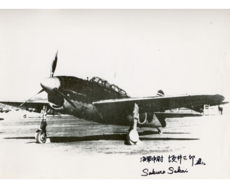
Lot 1018
KAMIKAZES: Small selection of signed documents by few of the most famous Japanese kamikazes, comprising Mitsuo Fuchida (1902-1976) Captain of the Japanese Navy, and bomber Aviator during WWII. Best known for leading the first air wave attacks on Pearl Harbour on 7 December 1941. Signed 12 x 8.5 copy of a map showing the Kamikazes route to Pearl Harbour. Signed twice, in bold blue ink, in occidental and Japanese characters, to a clear area of the image; Saburo Sakai (1916-2000) Japanese naval Aviator and flying ace of the Imperial Japanese Navy during World War II . Signed 12 x 11 photograph by Sakai, the image depicting an aircraft fighter. Signed twice, in bold black ink, in occidental and Japanese characters, to a clear area of the image; and Ryuji Nagatsuka (1924- ) Japanese Kamikaze survivor. Professor at Tokyo University and Author of the work `I was a Kamikaze. The Knights of the Divine Wind´ (1973). Signed 8 x 12 image showing a reproduction of the Nakajima Ki-44-I, a Japanese aircraft fighter. Signed in bold red ink, in Japanese characters, to a clear area of the image. EX, 3 £150-200


![FORBES, J.D. The Tour of Mont Blanc and of Monte Rosa. [Folding map.] Black, Edinburgh, 1855, 1st edn., cloth gilt. ROSE, W.](https://cdn.globalauctionplatform.com/88fa6989-0903-4346-ab15-a51700ad7780/e44817fc-a61f-4dec-93ce-6d5fb6efbfb1/468x382.jpg)
Lot 138
GEORGE, H.B. The Oberland and its Glaciers: explored and illustrated with Ice-Axe and Camera. [Map, 28 original mounted photographs.] Bennett, 1866, 4to, cloth gilt. WHYMPER, E. Swiss Pictures drawn with Pen and Pencil. RTS, [ca. 1870], 4to, cloth gilt. TURNER, D. Account of a Tour in Normandy. Engravings. Arch, 1820, 2 vols., pink calf gilt. (4)
![BARBER. Barber's Picturesque Illustrations of the Isle of Wight. [Steel engravings.] Simpkin & Marshall, [ca. 1835], contemp.](https://cdn.globalauctionplatform.com/88fa6989-0903-4346-ab15-a51700ad7780/2c41e745-3e71-4a52-ba07-4fc2ce5ae5dd/468x382.jpg)
Lot 141
BARBER. Barber's Picturesque Illustrations of the Isle of Wight. [Steel engravings.] Simpkin & Marshall, [ca. 1835], contemp. green morocco, a.e.g. ANON. A New, Correct, and much-improved History of the Isle of Wight. [Engraved folding map.] J. Albin, Newport, 1795, contemp. russia; and Vol. I (only) of Tomkins' Tour of the Isle of Wight, 1796, with sepia aquatint plates. (3)
![ROBERTS, George. The History and Antiquities of the Borough of Lyme Regis. [Coloured map frontis.] Bagster, 1834, cloth. WARN](https://cdn.globalauctionplatform.com/88fa6989-0903-4346-ab15-a51700ad7780/a6e01287-6bb1-40cf-8906-82c4425e59ad/468x382.jpg)
Lot 153
ROBERTS, George. The History and Antiquities of the Borough of Lyme Regis. [Coloured map frontis.] Bagster, 1834, cloth. WARNE, C. Dorsetshire: Its Vestiges, Celtic, Roman, Saxon, and Danish. Map frontis. Sydenham, 1865, cloth gilt. BOND, T. History and Description of Corfe Castle, in the Isle of Purbeck. Illus. Stanford, 1883, cloth. BANKES, G. The Story of Corfe Castle. Frontis. Murray, 1853; and two copies of a pamphlet on the Dorset militia. (6)

![SAVAGE, James. History of the Hundred of Carhampton, in the County of Somerset. [Frontis., folding map.] Strong, Bristol, 183](https://cdn.globalauctionplatform.com/88fa6989-0903-4346-ab15-a51700ad7780/3abfc67a-cd72-45d8-bf61-9aa42d416094/468x382.jpg)
Lot 158
SAVAGE, James. History of the Hundred of Carhampton, in the County of Somerset. [Frontis., folding map.] Strong, Bristol, 1830, half calf. BRITTON, J. The History and Antiquities of Bath Abbey Church. [Engravings.] For the Author, 1825, roan-backed boards, label. LYTE, H.M. A History of Dunster. Illus. St Catherine Press, 1909, 2 vols, buckram; and others on Somerset. (7)


Lot 166
GREENWOOD, C. & J. Map of the county of Essex from an actual Survey made in the Year 1824. Greenwood Pringle & Co., 1825, folio, six double-page engraved maps, contemp. roan-backed boards. CARY, J. Cary's New and Correct English Atlas: being a New Set of County Maps. Cary, 1787, 4to, half calf worn; and two atlases and 2 vols. maps. (6)
![COLLINSON, John. The History and Antiquities of the County of Somerset. [Engravings.] Cruttwell. Bath, 1791, 3 vols. 4to, lat](https://cdn.globalauctionplatform.com/88fa6989-0903-4346-ab15-a51700ad7780/077001c5-090e-47cf-9e45-f35f3237d8a8/468x382.jpg)
Lot 173
COLLINSON, John. The History and Antiquities of the County of Somerset. [Engravings.] Cruttwell. Bath, 1791, 3 vols. 4to, later panelled calf, lacks map but generously extra-illustrated throughout with engravings, documents, annotations &c. WEAVER, F.W. Index to Collinson's History of Somerset. Taunton, 1898, 4to, uniform with the main work. LOCKE, R. Supplement to Collinson's History of Somerset. Taunton, 1939, 4to, cloth, two copies; together with a folder of ms notes on Somerset antiquities and genealogy, mostly late 19th. c. but with two original documents, 1720s. (7)
Lot 174
STUCKY, John. A Compleat History of Somersetshire . . . To which is added, A Scheme of all the Market-Towns, &c. Sherborne, 1742, folio, calf, old restorations to title. WARNER, Richard. The History of Bath. [Portrait, map, plates.] Cruttwell, Bath, 1801, 4to, half morocco; and another on Somerset. (3)

Lot 179
BRITTON, J. A Topographical and Historical Description of the County of Wilts. Illustrated with engravings. Sherwood, 1814, extra-illustrated and with type-facsimile title-pages extended to 2 vols., half morocco. COX, Thomas. Dorset. [Pages and map extracted from Magna Britannia, or A Topographical, Ecclesiastical and Natural History, ca. 1700, with specially printed title-page of ca. 1880]; and similar extracts, all with maps, for Somerset (2 copies) and Hampshire, 4to, half roan. (6)
![POPE, Alfred. The Old Stone Crosses of Dorset. [Plates, map.] Ling, Dorchester, 1906, 4to, cloth. ABBOTT. Abbott's Illustrate](https://cdn.globalauctionplatform.com/88fa6989-0903-4346-ab15-a51700ad7780/84d50c46-5202-4819-8006-9d3c31bf779a/468x382.jpg)
Lot 180
POPE, Alfred. The Old Stone Crosses of Dorset. [Plates, map.] Ling, Dorchester, 1906, 4to, cloth. ABBOTT. Abbott's Illustrated Counties. Dorsetshire. [Map, illus.] Guide Printing Co., 1896, 4to, cloth. NIGHTINGALE, J. The Church Plate of the County of Dorset. [Illus.] Bennett, Salisbury, 1889, cloth, presentation from author. OSWALD, A. Country Houses of Dorset. With 200 illustrations and a map. Country Life, 1935, 4to, cloth worn; and others on Dorset including a quantity of Notes & Queries for Somerset and Dorset, Sherborne, ca. 1906-14. (45)

![LYSONS, Daniel and Samuel. Magna Britannia . . . Volume the Sixth, containing Devonshire. [Map, plates.] Cadell, 1822, 4to, c](https://cdn.globalauctionplatform.com/88fa6989-0903-4346-ab15-a51700ad7780/0d966c43-3d62-43b5-9ed8-332afa4c990b/468x382.jpg)
Lot 185
LYSONS, Daniel and Samuel. Magna Britannia . . . Volume the Sixth, containing Devonshire. [Map, plates.] Cadell, 1822, 4to, calf. DAVIDSON, J. The British and Roman Remains in the vicinity of Axminster. [Frontis.] Nichols, 1833, cloth-backed boards, label. BARING-GOULD, S., and R. Twigge. An Armory of the Western Counties. Commin, Exeter, 1898, cloth. (3)

Lot 193
HUISH, Richard. The Charity of Richard Huish Esq. in Taunton, containing copies of his will and the Decree in Chancery respecting the same. Pool, Taunton, 1823, half calf, relevant letters and printed ephemera bound in or inserted. YEOVIL. Reports of the Commissioners for Enquiry concerning Charities . . . relating to Yeovil. Ca. 1830, other similar ms or printed documents bound in or inserted. YEOVIL. Reference to the Map of the Town of Yeovil. Thomas Ham, Yeovil, 1833, half calf, worn; and another of Yeovil interest. (4)

-
109182 item(s)/page