We found 109198 price guide item(s) matching your search
There are 109198 lots that match your search criteria. Subscribe now to get instant access to the full price guide service.
Click here to subscribe- List
- Grid
-
109198 item(s)/page


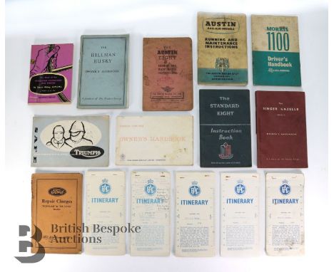
Lot 336
Collection of vintage car handbooks and instruction manuals, including Ford Consul Cortina Owner's Handbook 1964, The Standard Eight Instruction Book with fold out to bak, The Singer Gazelle series VI Owner's Handbook, Morris 1100 Driver's Handbook, Austin A40/50 Models Running and Maintenance Instructions June 1955, Austin Eight Running and Maintenance Instructions Sept 1946, The Hillman Husky Owner's Handbook Issued 1955 with fold out to back, The Book of the Standard Vanguard and Ensign - all models up to 1961, plus Safe Motorcycling with Triumph 1957, Ford Repair Charges 'Popular' & 'De Luxe' models April 1937 with paper insert. Together with five RAC itinerary map route booklets, including Birmingham to Sussex (through Coventry, London, Surrey and another through Stratford Upon Avon, Oxford, Henley-on-Thames)and Birmingham to Exeter (through Cheltenham, Tewkesbury, Bristol). (15)Condition ReportSome annotations, split bindings, and some signs of water damage, please see images for details.

Lot 463
Trade Cards - Drapkin 'Austrian and English Test Cricketers (40), Barratt's ' Famous Footballers (50), Cadet Sweets 'Footballers' (50), Carreras 'Popular Footballers' (48) plus 'Famous Footballers' (48), Church Map 'Association Footballers' (50) x 2, Players Association Cup Winners (50) Sinclair English and Scottish Football stars (5)) and others


Lot 480
Jacques Callot (French, 1592-1635) with Abraham Bosse (French, 1604-1676) and Michel Lasne (French, 1590-1667). Large etching titled "Obsidio Rupellae" depicting the siege of La Rochelle, ca. 1628-1631. Complete set of sixteen plates framed together to depict a battle scene bordered with cartouches. The central scene depicts an aerial or bird's eye view of the battle framed by panels bearing descriptions, additional scenes in cartouches, and portraits. Callot etched the central scene and two of the smaller scenes in the border while Lasne and Bosse, and possibly Israel Henriet (French, 1590-1661), etched the portraits and the remaining border.Unframed; height: 56 1/2 in x width: 65 in. Framed; height: 58 in x width: 66 1/4 in x depth: 1 1/4 in.Condition: There is heavy toning and uneven discoloration throughout all the prints. Areas of foxing and small stains throughout. There is undulation to the sheets. The sheets have been framed together to form one large map. There are creases throughout. Wear to the frame, framed under plexiglass. Due to the nature of the framing, this has not been inspected out of frame.

Lot 481
Jacques Callot (French, 1592-1635) with Abraham Bosse (French, 1604-1676) and Michel Lasne (French, 1590-1667). Large etching titled "Obsidio Arcis Sammartianianae" depicting the naval siege of the island of Re, ca. 1628-1631. Complete set of sixteen plates framed to depict the seige bordered with cartouches. The central scene depicts an aerial or bird's eye view of the island framed by panels bearing descriptions, additional scenes in cartouches, and portraits. Callot etched the central scene while Lasne and Bosse etched the bordersUnframed; height: 57 1/2 in x width: 64 3/4 in. Framed; height: 58 1/2 x width: 65 3/4 in x depth: 1 1/4 in.Condition: There is heavy toning and uneven discoloration throughout all the prints. Areas of foxing and small stains throughout. There is undulation to the sheets. The sheets have been framed together to form one large map. There are creases throughout. Wear to the frame, framed under plexiglass. Due to the nature of the framing, this has not been inspected out of frame.

Lot 485
Group of two antique map engravings including:Johannes Kip (Dutch, 1653-1722) after a painting by Leonard Knyff (Dutch 1650-1722). Etching on paper titled "Badminton in the County of Gloucester" depicting a bird's eye view map. Published in London in 1705.Olfert (Olivier) Dapper (Dutch, 1636-1689). Engraving on paper titled "Nagapatam (Rynlandsche Roeden)" depicting a bird's eye view map, published in 1672.Provenance: From the Estate of C. Curtis "Curt" Dunnavan, Long Lake, Minnesota.C. Curtis "Curt" Dunnavan (1926-2022) was a passionate world traveler and avid collector. It was through his travels that he was inspired to begin a lifelong relationship with the Minneapolis Institute of Art (Mia), becoming a major sponsor of the institute and facilitating the growth of their Asian art department, which is now one of the best in the country. His generous donations to Mia allowed them to establish a fund for the Deputy Director and Chief Operating Officer, one of the few endowed positions of this type in the museum field. He additionally served as a trustee of the institute, advocating for its operational growth. In its turn, the museum established a gallery named in his honor in recognition for his endowment fund and numerous contributions to their collection. The selections here showcase his talent and breadth of collecting, ranging from ancient statues to 19th-century woodblock prints. His appreciation for art persisted throughout his life and we are honored to offer items from his collection in this auction.Nagapatam; sight; height: 14 1/2 in x width: 11 1/2 in. Framed; height: 23 in x width: 20 in. Gloucester; sight: height: 14 1/2 in x width: 19 1/2 in. Framed; height: 24 in x width: 29 in.Condition: Nagapatam: there are no major visible rips, tears, losses, or restorations. There is a horizontal crease through the center of the sheet. There is light undulation to the sheet throughout. Some light soiling, located primarily along the margins. There is a light discoloration along the right upper quadrant. Light wear to the frame. Framed under glass. Not inspected out of frame.Gloucester: no major visible rips, tears, losses, or restorations. There is a vertical crease through the center of the print. Toning to the sheet. Foxing and light discoloration to the sheet throughout. Light wear to the frame. Framed under glass. Not inspected out of frame.

Lot 483
Engraving depicting a map of Colombo Fort as an octagon in Colombo, Sri Lanka. From Awnsham and John Churchill's "A Collection of Voyages and Travels" published in 1744 in London by Henry Lintot and John Osborne. Originally published in Philippus Baldaeus', also known as Philips Baelde, "The True Exact Description of the East Indian Countries of Malabar, Coromandel, Ceylon," ca. late 17th century.Provenance: From the Estate of C. Curtis "Curt" Dunnavan, Long Lake, Minnesota.C. Curtis "Curt" Dunnavan (1926-2022) was a passionate world traveler and avid collector. It was through his travels that he was inspired to begin a lifelong relationship with the Minneapolis Institute of Art (Mia), becoming a major sponsor of the institute and facilitating the growth of their Asian art department, which is now one of the best in the country. His generous donations to Mia allowed them to establish a fund for the Deputy Director and Chief Operating Officer, one of the few endowed positions of this type in the museum field. He additionally served as a trustee of the institute, advocating for its operational growth. In its turn, the museum established a gallery named in his honor in recognition for his endowment fund and numerous contributions to their collection. The selections here showcase his talent and breadth of collecting, ranging from ancient statues to 19th-century woodblock prints. His appreciation for art persisted throughout his life and we are honored to offer items from his collection in this auction.Sight; height: 12 in x width: 14 1/4 in. Framed; height: 20 in x width: 23 in.Condition: Overall no major visible losses, tears or restoration. There is a vertical crease through the center of the sheet. There is discoloration particularly along the lower right quadrant. There is slight foxing throughout, particularly in the center of the sheet. Light wear throughout the sheet. Light wear to the frame. Framed under glass. Not inspected out of frame.

Lot 698
Clapham (A.R) Tuting (T. G.) and Warburgh (E.S), Flora of the British Isles, 2 vols., 4to, cloth, illus. by Sybil J. Roles, Cambridge 1957 and 1960; Strasburger (Dr. Eduard), Noll (Dr. Fritz) and others, A Text-book of Botany, 8vo, illus., third edition, 1908; Furneaux (W.), British Butterflies and Moths, 8vo, cloth, illus., 1897; Wells (H.G), Huxley (Julian) and Wells (G.P.), The Science of Life, 4to, cloth, illus., first edition 1931; Pennant (Thomas), Some Account of London, 8vo, cloth, illus. with fold-out map and engraved title page, 1813; A catalogue of the Sale By Auction of the Haskell F. Morman Library of Science and Medicine, 3 vols, 4to, cloth, illus., Christie's New York 1998; and 3 Natural History books. (12)


Lot 674
Hutchinson (William), The History of the County of Cumberland, and Some Places Adjacent, two vols., 4to, calf, illus. with engravings and fold-out map and plates, Carlisle 1794; and Lysons (The Rev Daniel and Samuel) Magna Britannia, vol 4 - Cumberland, 4to, half calf and marbled board, illus. with engraving map and fold-out plates, 1816.

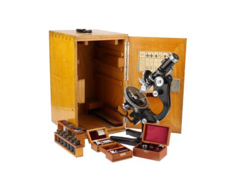
Lot 305
An Important Leitz AM Petrological Microscope From the Geological Survey, With Provenance, German, c.1936, engraved to the front of the body tube 'Ernst Leitz Wetzlar' and 'GS 280' (Geological Society) and engraved on most parts, objectives and eyepieces 'GS280', numbered on the card in the door 323053 the microscope standing on a large and heavy black enameled base, with locking adjustment to the incline, with plano-concave mirror focusing substage condenser with polariser, focusing stage to be used in conjunction with the vertical illuminator so as not to displace the position of the illuminator in relation to an external light source, stage with large removable central section so the microscope can be used with a Universal Stage, body tube with Bertrand lens (along with a hand-drawn chart ) with rack and pinion focusing, analyser with adjustment and scale, in a large wooden case with 7 Leitz objectives 6 of which are engraved GS280, a Berek Compensator engraved GS280 and engraved 1914 along with a hand-drawn chart (damaged), a cased mechanical stage, another Berek compensator engraved GS619 The microscope was sold by the Geological Society back in 1984 to Peter Aubry Sabine for £115.00 and comes with all of the paperwork relating to the sale. According to the records held by the British Geological Society the microscope was bought in 1936 presumably for Dr Phemister, who was recorded as having it in 1937. Dr. Phemister was appointed Official Petrographer in 1935, a post he held until he became Assistant Director in 1946. Dr James Phemister was a renowned geologist whose contributions to the field of earth sciences were significant. He was born in Scotland in 1903 and spent most of his life working as a geologist in the UK. Dr Phemister's expertise in the field of geology earned him a high reputation among his peers and the scientific community. Dr Phemister's career began at the University of Edinburgh, where he earned a degree in geology. He then went on to study at the University of Cambridge, where he obtained a PhD in 1928. After completing his studies, Dr Phemister joined the British Geological Survey, where he worked for over 30 years. During this time, he made significant contributions to the study of geology in the UK. Dr Phemister's work was not limited to the UK, however. He also worked on geological surveys in Africa and South America. In Africa, he worked on a geological mapping project in the Congo, where he discovered the presence of copper deposits. In South America, he worked on a project to map the geology of the Andes mountains, which helped to improve our understanding of the tectonic processes that shape mountain ranges. Dr Phemister was also an active member of the Geological Society of London, where he played an important role in the development of the society. He was elected a Fellow of the society in 1939 and served as its President from 1953 to 1955. During his tenure as President, Dr Phemister worked to increase the society's membership and promote the study of geology. Apart from his work with the Geological Society, Dr Phemister was also an accomplished author. He published several books on geology, including "The Geology of Central England" and "The Geology of the South Wales Coalfield." These books were instrumental in advancing our understanding of the geological history of these regions. Dr Phemister's contributions to geology and earth sciences were recognized by many scientific societies in his lifetime. He was awarded the Wollaston Medal by the Geological Society of London in 1956 for his contributions to the study of geology. He was also awarded the Lyell Medal by the same society in 1966 for his contributions to geological mapping. In conclusion, Dr James Phemister was a pioneering geologist whose contributions to the field of earth sciences were immense. His work on geological mapping and his involvement in geological surveys in Africa and South America helped to improve our understanding of the geology of these regions. His tenure as President of the Geological Society of London was marked by his efforts to promote the study of geology and increase the society's membership. Dr Phemister's legacy lives on through his numerous publications and his lasting impact on the field of geology. Peter Aubrey Sabine, (b.1924 - d.2022) was as a prominent British petrologist and mineralogist born in London in 1924. He graduated with a geology degree from Imperial College London in 1945 and joined the Geological Survey and Museum (GSM) as a Geologist. Early in his career, he helped to reorganize the Geological Museum's specimens and showcases, sparking his interest in igneous petrology. In 1951, he received his PhD for investigating the minor intrusions of the Assynt district in N.W. Highlands. He was later promoted to Chief Petrographer and set about modernizing the Petrographical Department. He realized that the polarizing microscope for the optical characterization of rocks and minerals had been overtaken by more rapid and versatile techniques. He acquired the first X-ray diffraction (XRD) equipment by the late 1950s, followed by X-ray fluorescence (XRF) and differential thermal analysis (DTA) equipment. By the mid-1960s, modern X-ray diffractometer and image analysis equipment were installed, making the Petrographical Department the best equipped and staffed laboratory in the GSM. Sabine conducted various petrological studies, including contact metamorphism of chalk by Tertiary dolerite intrusions, resulting in several seminal publications. He provided the first detailed petrographical description of the granite found on Rockall, a tiny Atlantic island, after the first landing by the Royal Navy in 1955. Sabine was the longest-standing member of the Mineralogical Society at the time of his death, having joined in 1945 and becoming Vice President of the Geological Society in 1966. In 1977, he became Chief Geochemist at the Gray's Inn Road office of the renamed British Geological Survey (BGS) and later returned to the Exhibition Road as Deputy Director. However, he retired at the end of 1984 when the BGS relocated its headquarters to a site near Nottingham. Sabine's legacy includes groundbreaking research and modernization in petrology and mineralogy.


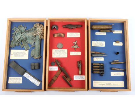
Lot 376
Grouping of Artifacts Picked Up as Souvenirs From Gravesend Kent and the Surrounding Areas During WW2, mostly been nicely framed with labels, one frame with a locally made wooden model of a V1 flying bomb, pieces of shrapnel, round cases, piece of parachute rigging from a dropped mine picked up at Callender’s Cable Works Erith, some radar jamming foil paper, anti-aircraft shell head, etc. Also a street plan map of Gravesend detailing bomb drops in 1944. Interesting grouping. Please note all items are inert and legal to own. Due to the nature of this lot, we are not able to offer postage. Personal collection only.

Lot 930
Grouping of Documents and Awards Relating to Pahl Family and Two Sons, Both Who Were Killed During WW2, the grouping relates to the service of Edmund Pahl and Otto Pahl. Consisting of 1939 Iron Cross 2nd class with its original citation awarded to Gefreiten Pahl 6./ Inf Rgt 55, which was awarded on 9th November 1939 and is signed by Knights Cross winner and commander of the 17th Infantry division Generalmajor Herbert Loch. Also accompanying these items is a typed document sent to the family on 10th December 1939 which translates as, ‘The company is sending you the award certificate for the Iron Cross II class, which your son Edmund, who unfortunately died so young, earned through his brave behaviour in the campaign against Poland’, and also a handwritten letter dated 27th November 1939 assuming from his commanding officer, possibly describing the action in which their son was killed. Black wound badge and award certificate also awarded to Edmund Pahl for a wound on 12th September 1939, presented in the field 11th January 1940, obviously posthumously, as it would appear he was killed or died in 1939. Small photograph believed to be Edmund Pahl in uniform and two other documents sent to the father, Albert Pahl; Grouping of documents of Otto Pahl, who served in 8./Inf Rgt 186, including preliminary award document for the Krim shield (Krimschild) award with signature of Generalfeldmarschall von Manstein, printed document relating to Obergefreiter Otto Pahl and the forwarding of a photograph of his grave dated 6. November 1944. Another typed document relating to the death of Otto Pahl and his grave. Hand drawn map on tracing style paper, typed document in relation to a wound and another typed document in two. These are accompanied by a reproduction Krim shield. An interesting family group.

Lot 38
MAP OF THE HIGHWAYS OF EMPIRE ISSUED BY EMPIRE MARKETING BOARD, CIRCA 1927 a large illustrated map, printed for H.M. Stationary Offcie, by Waterlow & Sons, London, with an illustration by Macdonald Gill, linen backed101cm x 150cmLower text appears varnished, map itself isn't.Number of vertical creases. Further creases, tears and areas of discolour as per additional images.
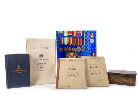
Lot 30
MEDAL GROUP AND ARCHIVE RELATING WILLIAM ARTHUR ROSVEARE WWII-PERIOD the medal group comprising the 1939-45 Star, the Atlantic Star, the Africa Star, the War Medal, and the Naval Long Service and Good Conduct Medal (this inscribed to K. 65708 ... S.P.O. H.M.S. Curlew), along with two further commemorative medals, exercise books and manuals including two S.O. Books 135 - Engineering Lectures and Sketches (these circa 1930s), a Stokers' Manual 1927, photographs and service documents, Survey Dept. quarter inch map of Ceylon, a double sided cloth map of Borneo, Sumatra and Java, and other effects
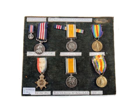
Lot 56
TWO SERVICE MEDAL GROUPS, AWARDED TO BROTHERS SGT. J.H. DOWNEY AND BMBR. W.A. DOWNEY WWI the first comprising the War Medal, Victory Medal and Military Medal (BUFFED & RE-INSCRIBED) (w/miniature), these inscribed for 58613 A.C. SJT... M.G.C., presented alongside M.M. Citation, Record of the act for M.M., letter to Downey from E.T.A. Heep, Machine Gun Corps Christmas 1918 Greetings Card, a trench map - Field Survey Co., R.E. (2578) 15.9.17 Edition 1, a handwritten booklet on the Third Battle of Ypres, a Baptisimal certificate dated 1891, for St. Anne's Soho School Attendance silver medals circa 1900-04, a small album of sketches and writings, four photographs (two early, two later), and a lap desk awarded to him in 1908; the second compising the 1914-15 Star, War Medal, Victory Medal and Death Penny Memorial Plaque, these inscribed for 85104 A. BMBR. W.A. DOWNEY, R.F.A., presented alongside Death Scroll, a photograph of him in uniform, three St. Anne's Soho School Attendance silver medals circa 1901-04, and a pocket worship bookNote: The citation of award for gallantry, 'For great initiative and courage displayed by him in the neighbourhood of St. Julien on the 26th September. At the commencement of operations this N.C.O. was in charge of 2 guns. He successfully led these guns forward to their objective. WHen he found that a section that had advanced on his left had lost all Officers and N.C.O.'s and had become disorganised, he went forward to them in spite of heavy sniping and re-established them in their positions in the front line. By his courage and initiative he averted what might have been a disaster.'As per letter from E.T.A. Heep, 'Thanks awfully for your kind letter. I am glad you got through safely and trust your good luck will continue. I hear from Capt. Drew that he has recommended you for a medal. I hope you get it as I always said you were the best sergeant in the Company and No.4 was the best section. Extraordinary, wasn't it, how we always got all the work to do. I hope you don't keep up that tradition. ...'PLEASE NOTE, THE MILITARY MEDAL HAS BEEN BUFFED AND RE-INSCRIBEDPHOTO UPLOADED


Lot 37
MAP OF AUSTRALIA ISSUED BY EMPIRE MARKETING BOARD, CIRCA 1930 a large illustrated map, printed for H.M. Stationary for Eyre & Spottiswoode Ltd., London, with an illustration by Macdonald Gill, titled Map of Australia portraying her agricultural products and fisheries, linen backed102cm x 150cmMap not laminated or varnished.Tear to lower right within plate. Areas of staining to lower and upper sections. Other minor tears, creasing, stains as per additional images.


Lot 36
MAP OF THE IRISH FREE STATE AND NORTHERN IRELAND ISSUED BY EMPIRE MARKETING BOARD, CIRCA 1929 a large illustrated map, printed for H.M. Stationary for Eyre & Spottiswoode Ltd., London, with an illustration by Macdonald Gill, titled Irish Free State & Northern Ireland portraying their agricultural products and fisheries, linen backed101cm x 150cmMap is not laminated or varnished.Condition good to fair. Crease running length of left hand side. Two stains to lower edge. Further creases, wear, stains and tears as per additional images.

Lot 316
Collection of British First World War Trench Maps, the maps are attributed to Brigadier General Herbert Cecil Potter (10/10/1875-11/6/1964) Officer Commanding the 9th Infantry Brigade, 3rd Division, during the Battle of the Somme and 3rd Battle of Ypres, the maps, detailed below, are of areas in which Potter served throughout the war from 1914 and include detailed information of enemy trenches marked in red on each map, some are particularly evocative, the map of Hebuterne containing the village of Serre with 'Matthew', 'Mark', 'Luke', 'John' Copses, all clearly marked and bring to mind the tragic first day of the Battle of the Somme, a map of Delville Wood is annotated in pencil with 'Delville Wood and Guillemont, 9 Bde attack 16/8/1916' , another map gives the 'German Order of Battle, Cambrai 1 Dec 1917', a map of the 'Seine, Meuse, and Rhine Basins Showing Areas of Occupation of the Allied Armies Jan 1919' is marked with the ink stamp of 'HQ 9th Infantry Brigade', the maps were given to the vendor when a young man by General Potter's son Major Cecil Potter, a family friend in Somerset, some are heavily used and stained with the mud of the front line, many of the annotations on the maps are believed to have been made by General Potter contemperaneously, while some, particularly on the French made maps, are believed to have been done by Major Cecil Potter post warBrigadier General Herbert Cecil Potter CB, CMG, DSO was born in Nagasaki, Japan, educated at Bedford Modern School and Sandhurst, joined the Kings (Liverpool) Regiment as 2nd Lieutenant 29/2/1896, promoted Lieutenant, March 1899, then Captain, December 1900, seconded to a Mounted Infantry Column in South Africa 1901-02 (2nd Boer War) served in the Sudan in 1908 and the Western Front throughout the First World War, wounded through both legs in August 1914, he returned to the front line and given command of 9th Infantry Brigade in April 1916, during the Battle of the Somme General Potters recce of High Wood with two other officers, and the realisation that it was clear of Germans and could be occupied easily is detailed on Page 137/138 of 'Somme' by Lyn MacDonald, '...There was not a German to be seen. The commanders decided to look for themselves. General Potter of the 9th Brigade of the 3rd Division, with Lieutenant Colonel Elliot and Major General Watts Commander of the 7th Division were not so foolhardy as to expose themselves by walking along the track at the top of the slope but, hugging the the shelter immediatley below, clambered along to the ruined windmill, a hundred yards or so to the right.... looking across the gentlest of valleys, where the ridge on which they stood sloped down to a hollow and rose almost imperceptibly to the dark mass of High Wood itself,...Nothing stirred in the cornfields. High Wood was silent...Then they crossed the cornfield almost to the edge of High Wood. Not a shot was fired. High Wood was empty. Jubilant, excited, and anxious to push ahead, they almost ran back to the line. The troops were fresh and ready to go...', tragically, the information was not acted on in time, the Germans reoccupied the wood and High Wood was not taken until September after heavy fighting and many casualties, Potter was twice wounded at the Somme in August 1916, the second time by a 'large shell which sat down beside me and made me stone deaf for some days', Potter also served at the Battle of Arras April-May 1917, and the 3rd Battle of Ypres (Passchendaele) July-November 1917, as well as the Queens South Africa Medal with three clasps Potter was awarded a medal and clasp, 4th Class Osmanieh, 3rd Class Mejidieh in Sudan (1908),mentioned in depatches in WW1, decorated with the Legion of Honour by Sir Douglas Haig in November 1915, made DSO in 1917 and CMG in 1918, he retired from the army in 1927, the maps included in the lot are;Delville Wood Map, large scale, trench lines/road names marked in red (Fleet Street, High Holborn, Bond Street, Regents Street, etc) with reverse marked in pencil (believed by Major Cecil Potter) 'Delville wood and Guillemont, 9 Bde attack 16/8/1916'Trench Map - Hebuterne, Ordnance Survey 1916, scale 1:10,000 , 'Trenches corrected to 19:8:16', trench lines printed in red, additional markings in pencil (Bounderies, Pendant Alley, etc),'Matthew Copse', 'Mark Copse', 'Luke Copse', 'John Copse', which formed part of the British front line and forming up points for some of the Pals battalions are clearly marked, front of map marked 'Brigadier, Serre, Aug 1916''Seine, Meuse, and Rhine Basin Showing Areas of Occupation of the Allied Armies Jan. 1919', 1:1,000,000 scale map, showing Belgian, British, American, and French zones outlined in red, marked in pencil 'Occupation zones of the Rhineland 1919' bears stamps of 'HQ 9th Infantry Brigade' and 'General Staff 3rd Division' dated 7th February 1919French issue map of Melun, 1:80,000 scale, bottom left corner marked 'Revisee 1888', marked in pencil 'France, 1/80,000 map of Melun area (SE of Paris) probably issued in case of further retreat by BEF in August 1914'Map of Cambrai, 1:100,000 scale, British intelligence map showing German Order of Battle, Army Groups, Armies, Corps, Divisions, down to Regiments, including rest billets, all printed in red, marked to reverse 'German Order of Battle, Cambrai, 1 Dec 1917'Trench map, Ordnance Survey 1915, sheet 36c N.W. 3 and part of 1, scale 1:10,000, shows town of Loos, trench lines in red including 'Loos Road Redoubt', marked to the front in pen '**** 1915'Trench Map, scale 1:10,000, France, La Bassee, trenches marked in red including Holenzollern Redoubt, units marked in pen (19th Bde, Kings, 2nd South Staffords), marked to the front in pencil '1915'Trench Map, France, Sheet 57c S.W., scale 1:20,000, trench lines marked in red, Bazentin, Longueville, Guillemont, High Wood, Delville Wood, Flatiron Copse, Sabot Copse, Arrow Head copse, etc all shown, mud stained, marked in pencil to front 'Bazentin/High Wood'French issue map, Provins, marked bottom left corner 'Revisee 1888', marked in pencil 'Large scale map of Provins area (SE of Paris) probably issued in case of further retreat by BEF in August 1914', (qty)
Lot 317
First World War group of items to Lieutenant F.R. Bullard 2/1st Derbyshire Yeomanry, including, Yeomanry Pocket Book marked to the front 'F.R. Bullard 2/1 Derbyshire Yeomanry', Instruction to the Machine Gun booklet dated 1915, marked inside to 'F.R. Bullard 2/1 Derbyshire Yeomanry', Army Book 136 (Notebook) marked to the inside to 'F.R. Bullard, 2nd Lt., Transport Officer, 14 D.L.I.' which contains nominal roll of members of the Transport Section and their jobs, Vet, Drivers, Breakers, Farrier, etc, assorted ephemera including list of officers chargers with names and colours of each horse, C2121 Forms (Messages & Signals) with detailed notes and diagrams written on the back regarding the placement of barbed wire obstacles including man-loaded equipment scales, note from Brigade Transport Officer, 18th Infantry Brigade to Transport Officer 14 D.L.I. regarding detailing 4 men with horses or mules for transport duties in the Loos area, notes of field punishment awarded to 'Pte Fellows, H, 14488, 14 D.L.I. A Coy', (3 days C.B for disobeying G.R.O. 1032), letter to Bullard from a fellow officer dated 21/06/1917, includes some details of a trench raid, '...our last little stunt which was a complete success - Some Batt. this! Fifty Boches were killed and eight taken prisoner. Moffitt was in charge of the party, Rothfield, Bruce and an old officer Lasalles went over. Rothfield did extremely well and captured one Boche sentry at a house who he was obliged to pop in the neck before he could get him over the parapit. You must have laughed to see him roll down to our support line, Roth running like hell! I was with the M.O. but fortunately had little to do as we had but seven wounded, mostly slightly, including Bruce, and one killed...', pair of woolen puttees attributed to Bullard, Trench Map, Sheet 62c NW, River Somme, Peronne 'Trenches correct 8/1/17', scale 1:20,000, trenches marked in red including Mannheim Trench, Johannes Trench, Brasso Redoubt, Oder Trench, Koros Alley, etc, records show Lt. Frederick Ringer Bullard of 2/1st Derbyshire Yeomanry entered France on 18th October 1916 and entitled to the 1914-1918 British War Medal and Victory Medal which he applied for 25/08/1921, 2/1st Derbyshire Yeomanry was formed in 1914 and was part of 9th Mounted Brigade, 3rd Mounted Division in the U.K., in October 1916 4 Officers and 165 O/Rs from the regiment were drafted to France as reinforcements to the 14th Battalion Durham Light Infantry, including presumably Lt Bullard, Private Harry Fellows entered France on 11th September 1915 and is shown as entitled to the 1914/15 Star, BWM and Victory Medal, demobilised to Class Z, vendor states he was gifted the items by Bullards niece in the late 1990s
Lot 146
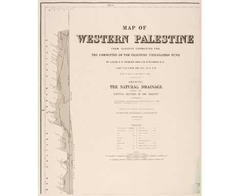
Palestine. Conder (Lieuts. C. R. & Kitchener H. H.), Map of Western Palestine from Surveys Conducted for the Committee of the Palestine Explorations Fund..., Reduced from the One Inch Map..., Shewing the Natural Drainage together with the Vertical Sections of the Country, Stanford's Geographical Establishment, 1884, engraved map, printed in colours on 6 (complete) sheets, lacking boards, oblong folio, overall size 495 x 615 mm, together with Map of Western Palestine Surveys Conducted for the Committee of the Palestine Explorations Fund..., Reduced from the One Inch Map..., Stanford's Geographical Establishment, 1881, engraved map, printed in colours on 6 (complete) sheets, sectionalised and laid on linen, slight spotting, each sheet approximately 505 x 420 mm, contained in a contemporary cloth slipcaseQTY: (2)
Lot 162
The Stock Exchange. Whistler (Reginald John, 'Rex'), The Stock Exchange London 1933, London: The Financial News, 1933, colour photolithograph, additional cartouche with the title 'The Financial News map of the Stock Exchange' with a table of explanation below, numerous allegorical symbols and figures surrounding the map, slight spotting, very slight surface abrasion, laid on later card, 390 x 535 mmQTY: (1)NOTE:A scarce map crammed with allegorical symbolism. The cartouche is supported by a bear and a bull, the classic representations of a sellers and buyers market, and both are shown in morning dress. The secondary cartouche is flanked by King Midas who has coins spilling from his waist and Dame Fortune who is blindfolded and holding a pair of scissors and whose arm rests on the 'rota fortunae' or wheel of fortune, a symbol of the capricious nature of fate. In the upper corners of the map are representations of Mercury carrying an elaborate compass and the goddess Demeter spilling her cornucopia into the market. The stock exchange itself is shown as a castellated courtyard within whose walls commodities, gilts and bonds are depicted being traded by a variety of humorous vignettes.

Lot 153
Quebec. Jefferys (Thomas), An Authentic Plan of the River St. Laurence from Sillery to the fall of Montmorenci with the Operations of the Siege of Quebec under the Command of Vice-Adml. Saunders & Major Genl. Wolfe down to the 5th Sepr. 1759, Drawn by a Captain in His Majesties Navy, 1759, uncoloured engraved map, inset maps of the 'Action gained by the English Sepr. 13 1759 near Quebec' and the 'Port of the Upper River of St. Laurence', slight creasing and dust soiling, one short split at the base of the central fold, occasional marginal closed tears, 335 x 485 mmQTY: (1)NOTE:The first state which lacks Jeffeys's imprint before the price in the lower right corner.

Lot 93
Cooke (John). [A New Universal Atlas; Intended as a Companion to the Geography for Children and Other Introductory Works on that Subject, printed for J. Harris, 1804], lacking title page, 28 (complete) double-page engraved circular maps with contemporary outline colouring (the map of the solar system printed in aquatint with green ink) maps of Spain & Portugal and England & Wales with a split along the central fold, Spain & Portugal with a short closed tear, some offsetting and slight staining throughout, two maps with juvenile pencil scribblings to the verso, occasional finger soiling, hinges and joints weak, upper board near detached, contemporary half morocco with publisher's printed label to the upper siding, heavily rubbed and worn, 8voQTY: (1)NOTE:A scarce miniature atlas, not recorded in Philips Atlases or Geoffrey King's Miniature Maps. Sold as a collection of maps, not subject to return.

Lot 46
Simons (Mathew). A Book of the Names of all Parishes, Market Towns, Villages, Hamlets, and Smallest Places, in England and Wales. Alphabetically set down...a Work Very Necessary for Travellers, Quartermasters, Gatherers of Breefs, Strangers, Carriers, and Messengers with Letters..., London: Printed by M. S. for Tho: Jenner, 1657, original 1643 title page not retained in this copy (only additional title page present), folding engraved map of England & Wales (repaired closed tear and folds strengthened to verso), and thirty-eight engraved county maps (including folding map of Yorkshire), each map with triangular distance table, folding engraved table, lacking folding map of Wales (supplied in facsimile), some browning and scattered spotting, modern calf gilt, small 4to QTY: (1)NOTE:Chubb XLIX; Wing B3717.A greatly expanded version of "A Direction for the English Traviller", 1643 (Chubb XLIV), with letterpress text added to the engraved tables and maps. Page numbers 100 and 104 are omitted in the pagination.
Lot 38
Depping (George Bernhard). L' Angleterre, ou Description Historique et Topographique du Royaume Uni de la Grande-Bretagne, 6 volumes in 3, 1st edition, Paris: Etienne Ledoux, 1824, half-titles present, folding general map of England & Wales to volume 1 and fifty-nine engraved maps with original outline colouring, sixteen aquatint and engraved plates, folding table, bookplate of Cardinal Pietro Ciriaci to each volume, spotting, preliminary leaves of volume 1 with light damp-stain to gutter, contemporary sheep, morocco labels lettered in gilt, rubbed, 12moQTY: (3)
Lot 33
Camden (William). Camden's Britannia, Newly Translated into English: with large Additions and Improvements. published by Edmund Gibson of Queens College in Oxford..., London: Printed by F. Collins for A. Swale and A. & J. Churchill, 1695, engraved portrait frontispiece, 49 (of 50) uncoloured engraved double-page maps (including three folding Kent, Hertfordshire & Norfolk, bound without map 50 'The Smaller Islands in the British Ocean'), 8 plates of coins and one full-page engraving of antiquities, few woodcut illustrations and two engraved illustrations (Stonehenge & Rollright stones), without final leaf at rear of Index, light damp stain mostly to foot of gutter margins of some leaves at front of volume, occasional toning and minor spotting to few leaves, endpapers renewed, contemporary panelled speckled calf, modern rebacked with black calf title label, board corners repaired, light wear to boards, folio (38.8 x 23.5 cm)QTY: (1)NOTE:Chubb CXIII.
Lot 120
London & its Environs. A Collection of 30 maps, 18th - early 20th century, including Sayer (J. P.). Five (only) pictorial maps of London districts, originally published in 'Original Lithographic Prints Comprising the First Twelve up to October 1947, of the Series of Picture Maps of London...,' first published in the Strand Magazine, George Newnes Ltd. circa 1948, five colour lithographic pictorial maps of districts within London, A Map of the Strand, A Map of Blackfriars and New Bridge Street, A Birds-eye View of Hyde Park Corner, A Map of the Zoological Society's Gardens in Regents Park commonly called the Zoo [and] The Tower of London) each with an illustrated description to the verso, publisher's printed paper wrappers, each approximately 190 x 260 mm, together with Basire (J.). Plan of the River Thames with the Proposed Docks at Rotherhithe and in the Isle of Dogs for 814 Ships with Room for Shifting & Lighters,, Luke Hansard & Sons, 1803, engraved map with contemporary hand-colouring, old folds, some off-setting, 400 x 325 mm, with Seale (R. W.). A New Map of the Countries Ten Miles round the Cities of London & Westminster & Borough of Southwark, circa 1780, uncoloured engraved map, slight tape staining, 215 x 305 mm, plus three uncoloured engraved 18th-century ward plans from Noorthouck's 'History of London', each approximately 190 x 245 mm, with two county maps of Middlesex by Thomas Moule and J. Archer, plus other maps and plans including folding maps, with examples by or after Ordnance Survey, George Philip & Son, Imray Laurie Norie & Wilson, Beck and 'The Gentleman's Magazine', various sizes and conditionQTY: (30)

Lot 174
World. Troy (André), Les Ailes Françaises à Travers le Monde, 1943, large colour lithographic map of the world on a Mercator projection, old folds and closed tears, including retouching along old folds, skillfully repaired. laid on later linen, 685 x 1510 mmQTY: (1)NOTE:The poster, very much in the manner of Lucien Boucher, shows French air routes around the world. Curiously the poster appears to have been produced at the height of WW 2, after the surrender of France and the subsequent German invasion of the Vichy zone in November 1942. André Troy was a little-known French artist and illustrator who produced at least one poster for Air France (in 1936) and illustrated two or three of their promotional brochures during the late 1940s and early 1950s.
Lot 524
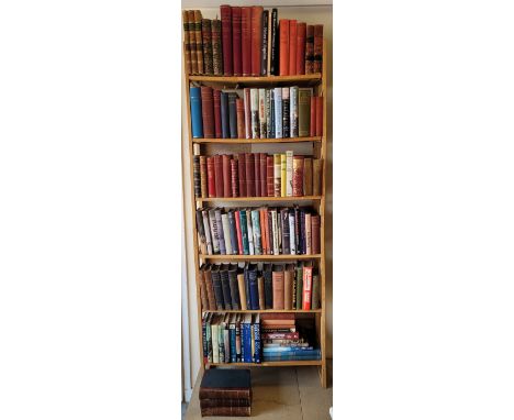
Napoleonic. A large collection of 19th-century & modern Napoleonic reference & related, including Life of Field Marshal, His Grace the Duke of Wellington, 2 volumes, by Alexander, London: Henry Colburn,1839, monochrome plates, some light spotting, volume 1 lacking the map, original half calf, slightly rubbed to head & foot, 8voThe Life of Wellington, 3 volumes, by Williams, London: Printing Co., original half calf, 8voThe Life of Napoleon Bonaparte, 4 volumes, by Sloane, The Century Co., 1906, monochrome plates, original bindings, some fading to the spine and boards of volume 4, 8vo, together with other 19th-century & modern Napoleonic reference & related, mostly original cloth, some leather bindings, some paperbacks, G/VG, 8voApproximately 110 volumesQTY: (6 shelves)
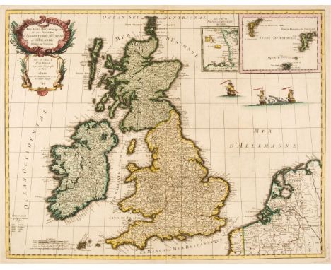
![British Isles. Mercator (Gerard & Hondius Henricus), Anglia, Scotia et Hibernia, [1628], hand-coloured engraved map, lar](https://cdn.globalauctionplatform.com/06960e46-dc7c-49b2-836c-b03600e595e8/855a9686-2e49-4828-ba5c-b037011fc5cf/468x382.jpg)
Lot 89
British Isles. Mercator (Gerard & Hondius Henricus), Anglia, Scotia et Hibernia, [1628], hand-coloured engraved map, large margins, 335 x 415 mm, French text on verso, together with Anglia Regnum [1613], uncoloured engraved map, large strapwork cartouche, slight creasing, 355 x 465 mm, Latin text on versoQTY: (2)NOTE:R. W. Shirley. Early Printed Maps of the British Isles 1477 - 1650, numbers 180 & 181.
Lot 87
British Isles. Le Rouge (George Louis), Les Isles Britanniques ou les Royaumes D'Angleterre, D'Ecosse, et D'Irlande; Divisées par Provinces, Paris, 1744, engraved map with contemporary wash colouring, two inset maps of the Channel Islands and of the Faroe and Shetland Islands, 500 x 640 mm, together with Le Royaume D'Angleterre Divisé en Comtez et Baronies..., Paris, 1745, engraved map with contemporary outline colouring, 575 x 490 mmQTY: (2)NOTE:R. W. Shirley. Printed Maps of the British Isles 1650 - 1750. Le Rouge 1 & Le Rouge 2. Both maps were published in the 'Atlas Général'.

Lot 117
Leicestershire & Rutland. Jansson (Jan), Leicestrensis Comitatus cum Rutlandiae vulgo Leicester & Rutlandshire, Amsterdam, circa 1650, engraved map with contemporary outline colouring, decorative cartouche and mileage scale, slight staining, 440 x 550 mm, together with Blaeu (Johannes). Leicestrensis Comitatus Leicester Shire, Amsterdam, circa 1660, engraved map with contemporary outline colouring, decorative mileage scale, 385 x 500 mm, Spanish text on versoQTY: (2)

Lot 106
* Ireland. Price (Charles), A Correct Map of Ireland, Divided into its Provinces, Counties, and Baronies shewing the roads and the distances of places in computed miles by Inspection, where Barraques are Erected &c, by Cha. Price. J. Senex and J. Maxwell, 1711, engraved map with contemporary outline colouring and some later enhancement, additional cartouche containing a dedication to Sir William Robinson, 960 x 670 mm, mounted, framed and glazedQTY: (1)NOTE:A. Bonar Law. The Printed Maps of Ireland, number 54 (i). The first state of three.
Lot 139
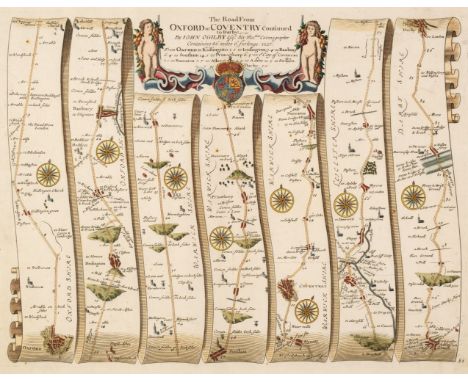
Ogilby (John). The Road from Oxford to Coventry Continued to Darby, circa 1676, hand-coloured engraved strip road map, 340 x 450 mm, together with The Road from Herford to Leicester, circa 1676, hand-coloured engraved strip road map, 345 x 450 mm, with an uncoloured duplicate and supplied with a page of contemporary explanatory text, plus The Road from London to Darby, circa 1676, hand-coloured engraved strip road map, 345 x 450 mm, supplied with a page of contemporary explanatory text, and The Road from London to Oakham in com. Rutland, circa 1676, hand-coloured engraved strip road map, trimmed to the plate mark and with its margins extended, toned overall, backed with later paper, 325 x 435 mm, with The Extended Road from Oakham to Richmond in Yorkshire, circa 1676, hand-coloured engraved strip road map, 335 x 435 mmQTY: (6)NOTE:Sheet numbers 82, 72 (2 copies), 40, 47 & 48.
Lot 4
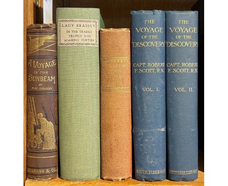
Brassey (Anne). A Voyage in the 'Sunbeam', Our Home on the Ocean for Eleven Months, London: Longmans, Green, and Co., 1880, half-title, wood engraved frontispiece, vignette to title and illustrations, folding colour lithograph folding map with short closed tear to fore-edge margin, occasional spotting to first and last few leaves, all edges gilt, original pictorial brown cloth, blocked in gilt and black, 8vo, together with:Brassey (Anne), In the Trades, the Tropics, & the Roaring Forties, London: Longmans, Green, & Co., 1885, wood engraved title and illustrations, 9 wood engraved colour printed maps (including 2 folding), occasional spotting and few marks, modern green cloth, 8vo,Collins (Charles Allston), A Cruise upon Wheels: the Chronicle of some Autumn wanderings among the deserted post-roads of France, 2nd edition, London: Routledge, Warne, and Routledge, 1863, half-title, engraved frontispiece, near contemporary cloth, spine faded, 8vo,Scott (Robert F.), The Voyage of the 'Discovery', 2 volumes, new edition, London: Smith, Elder, & Co., 1907, half-titles, colour frontispieces, monochrome plates, folding lithograph map, occasional scattered spotting, top edge gilt, remainder untrimmed, original dark blue cloth with inset monochrome pictorial panel to centre of each board (pictorial panel to 2nd volume lifting, creased and with slight loss, 8voQTY: (5)
Lot 23
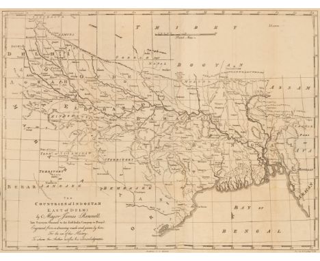
Orme (Robert). A History of the Military Transactions of the British Nation in Indostan, 3 volumes, including atlas, 4th edition, revised by the author, Madras: re-printed by Pharoah and Co., 1861, 35 lithograph maps, plates and plans (first map re-guarded, a few archival tissue repairs and some marginal insect damage), previous owner signatures and ink stamps to titles, a few annotations, some light spotting and toning, modern half calf, 8vo, together with Sachau (Edward C. editor). Alberuni's India. An account of the religion, philosophy, literature, geography, chronology, astronomy, customs, laws and astrology of India about A.D. 1030, 2 volumes, 1st edition, London: Kegan Paul, Trench, Trubner & Co., 1910, some light spotting, original cloth gilt in bright condition, a few small light marks, 8vo, plus Jackson (A.V. Williams). Persia Past and Present. A Book of Travel and Research, 1st edition, New York: The Macmillan Company, 1906, folding colour map, half-tone illustrations, advertisement leaf, top edge gilt, original cloth gilt edges lightly rubbed, corners a little bumped, 8vo, plus 2 others: The Game Animals of India, Burma, Malaya and Tibet, being a new and revised edition of 'The Great and Small Game of India, Burma and Tibet", by R. Lydekker, 1907, and The Baiga, by Verrier Elwin, 1st edition, 1939QTY: (8)
Lot 95
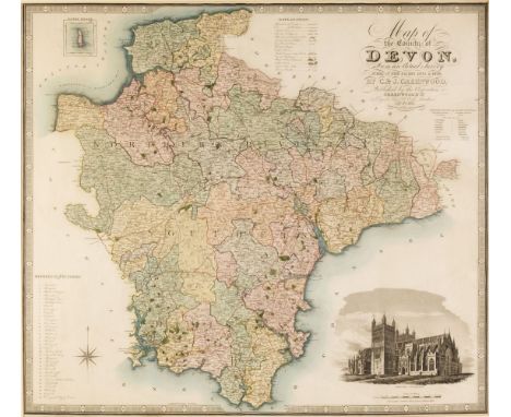
* Devon. Greenwood (C. & J.), Map of the County of Devon from an actual Survey made in the Years 1825 and 1826..., July 4th 1829, engraved map with bright contemporary wash colouring, inset map of Lundy Island, calligraphic cartouche, compass rose, table of reference and an uncoloured vignette of Exeter Cathedral, 620 x 700 mm, mounted, framed and glazed, together with Cary (John). A New Map of Devonshire, Divided into Hundreds Exhibiting its Roads, Rivers, Parks &c. October 26th 1807, engraved map with contemporary outline colouring, ovoid cartouche, compass rose and mileage scale, very slight staining, 490 x 545 mm, mounted, framed and glazed, with Stockdale (John). A Map of Devonshire from the Best Authorities, 26th March 1805, engraved map with contemporary outline colouring, compass rose and a list of the hundreds, 430 x 475 mm, mounted, framed and glazed, plus Harrison (J.). A Map of Devonshire engraved from an Actual Survey, 2nd July 1789, hand-coloured engraved and reticulated map, 345 x 470 mm, mounted, framed and glazed, and Kitchin (Thomas & Jefferys Thomas). A Map of Devonshire, 1749, engraved map with contemporary wash colouring, a list of the market towns below the map, 185 x 145 mm, mounted, framed and glazed, with another seventeen maps of Devon, including examples by or after Weller, James, Cary, Sayer, Hall, Moule, Smith, Hatchett/Walpoole, Kitchin J & C Walker and Whittaker , some duplicates, various sizes and condition, all framed and glazedQTY: (22)
-
109198 item(s)/page