We found 109198 price guide item(s) matching your search
There are 109198 lots that match your search criteria. Subscribe now to get instant access to the full price guide service.
Click here to subscribe- List
- Grid
-
109198 item(s)/page


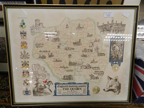


Lot 9
The Outstanding Second War 'Battle of the Bulge' M.C., 'POW Clandestine Operations' D.C.M., 'Operation Colossus' M.M. Group of Nine to Lieutenant, Late Sergeant, P.P. 'Clem' Clements, Parachute Regiment and X Troop 11 SAS. One of the Founding Members of the Airborne Forces, As Senior N.C.O. for X Troop He Took Part in the First British Airborne Raid, Operation Colossus, 10.2.1941. Taken POW after the Raid, He Undertook a Secret Role For MI9, Before Successfully Escaping from Sulmona Camp, 12.9.1943. Commissioned into the Parachute Regiment, He Led His Men With Distinction Against Heavy Armour in the Forests of Ardenne, 1945. He Was Wounded Four Times Fighting a Rearguard Action, Before Passing Out Due To Loss of Blooda) Military Cross, G.VI.R., reverse dated '1945'b) Distinguished Conduct Medal, G.VI.R. (2564415 Sjt. P.P. Clements. Leic. R.)c) Military Medal, G.VI.R. (2564415 Sjt. P.P. Clements. Leic. R.)d) India General Service 1936-39, one clasp, North West Frontier 1937-39 (2564415. Sjt. P. Clements. Leic. R.), partially officially renamede) 1939-1945 Starf) Africa Starg) Italy Starh) France and Germany Stari) War Medal, generally very fine or better, with the following related items:- Escaper's Compass, used by recipient- Escaper's map of the Swiss Frontier area; Emergency Ration tin- Diary, recorded in pencil whilst evading capture- Soldier's Service and Pay Book- Letter of thanks from MI9 to recipient, for work carried out in the POW camp, dated 16.11.1943- Letter of congratulation on the award of the D.C.M., from Lieutenant Colonel L. Winterbottom, MI9, dated 26.4.1944- Note written by recipient, whilst wounded in the Ardenne, requesting an ambulance for two wounded soldiers, signed and dated 6.1.1945, subsequently added to by recipient 'I started to write this but could not finish it off'- Letter of congratulation on the award of the M.C., from the commanding officer 12th Parachute Battalion- Portrait photograph of recipient in uniform, and a file of copied research into Operation Colossus (lot) M.C. London Gazette 12.4.1945 Lieutenant Percy Priestley Clements, D.C.M. (327224), Army Air Corps (Nottingham)The Recommendation states: 'On 5th January 1945 Lt. P. Clements commanded a platoon which was given the task of occupying a position on the feature North of Grupont dominating the area in which the 12th and 13th Parachute Bns were operating. The patrol reached its objective by 0300 hrs and took up a position as ordered. During the following nine hours the platoon lay up in a wood on the feature, which was also occupied by the enemy, reporting enemy movements and inflicting casualties including the killing of the officers of a recce group which approached the position.At about 1200 hrs the platoon came under accurate fire from close range. Lt. Clements, although fully exposed to enemy fire, personally passed the necessary fire orders for the artillery to engage the area held by the enemy. The enemy then brought up at least one Tiger tank which engaged the area held by the platoon. By this time the platoon was coming under accurate fire from the rear as well as the front. Lt. Clements then decided that the platoon must withdraw. He organised the withdrawal down the very exposed slope of the feature.At the first ...rd he was wounded in the stomach. Although he could not move himself he continued to command the platoon, and issued necessary orders for the remainder to withdraw. Throughout this period the platoon had no food and was exposed to very severe weather conditions. It was entirely due to the fine leadership, determination and example of this officer that the platoon carried out its task and was able to withdraw when this task had been completed.'D.C.M. London Gazette 2.3.1944 No. 2564415 Sergeant Percy Priestly Clements, The Leicestershire Regiment.<


Lot 193
Territories of New Mexico and Utah Second state of this very interesting map depicting the region with the largest configurations of the Utah and New Mexico territories. The Utah Territory encompasses all of today`s Nevada and extends west to the Continental Divide into present-day Colorado with Fillmore City as it`s capital. Nebraska and Kanzas Territories bound Utah on the east. New Mexico Territory includes part of southern Colorado and stretches west to include Arizona and the southern tip of present-day Nevada. Locates Fremont`s routes, proposed routes for the Pacific Railroad, the Cimarron Trail, the Oregon Route 1843, the Spanish Trail, and much more. A fine example of a very desirable map that Wheat found important enough to use as the frontis to Volume 4 of his Mapping the Transmississippi West. This is the more desirable edition with decorative borders from the large two volume atlas, dated 1855 and published in 1856-57. A clean, bright example with light toning along edges of sheet. 12.9"" W x 15.8"" H Colton, Joseph Hutchins 1855
![[Lot of 2] Map No. 1 [and] Map No. 2 Reconnaissance and Survey of a Railway Route from Mississippi River near 35th Parallel](http://lot-images.atgmedia.com/SR/36385/2916721/194-2014116143629_468x382.jpg)
Lot 194
[Lot of 2] Map No. 1 [and] Map No. 2 Reconnaissance and Survey of a Railway Route from Mississippi River near 35th Parallel to Pacific Ocean These are the larger maps that were included in the rare 8vo Pacific Railway atlas. They should not be confused with the same titled, smaller and much more common maps from the 4vo volume. This pair of matching maps are the result of the explorations and surveys of Lieut. A.W. Whipple and Lieut. J.C. Ives, Topographical Engineers, and A.H. Campbell, Civil Engineer. Wheat says Whipple ""had demonstrated that the route which he had surveyed was practicable for a railroad, and the Santa Fe Railroad now traverses much of it This is an important map, in its two parts, and reflects great credit upon Whipple and his entire party."" The first map extends from the vicinity of Memphis and Vicksburg to the Rio Grande valley at Santa Fe and Albuquerque. Locates forts Arbuckle, Washita, Smith and numerous Indian villages. Drawn by A. Schimmelfinnig. Map No. 2 continues from Albuquerque westward to Los Angeles via Cajon Pass. Also locates forts, Indian lands, pueblos such as Zuni, and the gold and silver mines in New Mexico. Drawn by M. von Hippel. The route of the exploring parties is delineated on both with each camp site indicated. The size given is approximate for each map: together they are over 12 feet in length! These maps are uncommon and are rarely offered together. Issued folding with light offsetting, numerous short splits at fold intersections, and toning along the folds. Map No. 1 has a 3"" binding tear at left. 26.5"" W x 75"" H Whipple, Amiel Weekes 1855
![[Lot of 2] Asher & Adams` Arizona [and] Asher & Adams` New Mexico A. Asher & Adams` Arizona (17.0 x 22.6"&q](http://lot-images.atgmedia.com/SR/36385/2916721/195-2014116143630_468x382.jpg)
Lot 195
[Lot of 2] Asher & Adams` Arizona [and] Asher & Adams` New Mexico A. Asher & Adams` Arizona (17.0 x 22.6""). This map shows an early Arizona with five very large counties that composed the territory of the time. The map displays major rivers, numerous mines, military and Indian reservations, and the progress of public surveys. It also depicts a few key roads and two proposed east-west rail lines across the territory. A small Navajo Reservation is noted in the northeast corner and Tucson is shown as the territorial capital. B. Asher & Adams` New Mexico (22.5 x 16.6""). Another double-page map focused on New Mexico with the southern portion of the state shown in an inset at right. 15 counties are noted and Santa Fe is shown as the capital. The map displays major rivers, proposed railroads, Indian and military reservations, the progress of public surveys, and Maxwell Grant along the border with Colorado. Light scattered foxing with some very faint offsetting in the New Mexico map. See description Asher & Adams, 1874

Lot 196
Air Navigation Map No. 32 (Experimental) Phoenix, Arizona to San Diego, Calif. In 1921, the United States Army Air Corps initiated a compressive evaluation of aeronautical charts in an effort to develop a standardized map for aerial navigation. Based upon this study, the Air Corps issued 63 air navigation maps covering most of the military routes in the United States. Prior to 1926, these maps were jointly compiled by the Geological Survey and U. S. Army Engineer Reproduction Plant. By 1926, the preparation of air maps shifted to the U.S. Coast and Geodetic Survey (under the Commerce Department) with the passage of the Air Commerce Act. Maps from this point on were intended to merge the growing commercial airways system with the military network. This map covers the area from Phoenix west to San Diego and shows elevation and contours, cities and towns, rivers, roads and railroads. Airfield classifications are shown with different symbols including seaplane landings. True north and magnetic north are depicted. On a scale of 8 miles per inch. Dissected into two panels and backed in linen. A colorful example backed in linen with light toning at bottom and an ex-library stamp on verso. 42.5"" W x 10.3"" H U.S. Corps of Engineers, 1924

Lot 198
A Diagram of the State of Alabama An early state map that shows surveying progress to 1840. There is no county development, but the settlements of Mobile, Montgomery, Cahaba, St. Stephens, Demopolis, Huntsville, Tuscaloosa, and Sparta are located. Large Indian Cession lands are shown including those of the Creek, Choctaw, Chickasaw, and Cherokee. Huntsville is located in the Old Madison County. Signed in the plate, ""Surveyor`s Office, Florence Alabama 25th. January 1840. Jas. H. Weakley Surveyor General of the Public Lands in Alabama."" Engraved by W.J. Stone. Issued folding with a hint of offsetting and faint scattered foxing mostly concentrated along the folds on the map`s top half. 22.6"" W x 11.7"" H General Land Office, 1840

Lot 202
Territory of Arizona This beautifully colored and highly detailed map shows the extent of nine Indian reservations and at least four military reservations including Fort Apache. Indian reservations are outlined in green, military reservations are shown in solid red, and private claims, confirmed and unconfirmed, outlined in red. The Grand Canyon Reserve is shown. The brown hachured mountain areas and the blue waterways combine to provide great visual impact. Information includes watershed, mountains, railroads, wagon roads, private claims, unsurveyed townships, etc. The Hopi reservation is still called the ""Moqui"" reservation. This edition was revised and reconstructed by R.H. Morton. A very handsome and historical map. Mint condition. Issued folding. 20.3"" W x 16.8"" H General Land Office, 1896

Lot 205
Reconnaissance of the Western Coast of the United States from San Francisco to San Diego by the Hydrographic Party Under the Command of Lieut. James Alden U.S.N. Assistant This terrific chart delineates the coast and is from the first official scientific reconnaissance of the Pacific coastal areas. It is one of three prepared by Lieutenant James Alden for this important survey. This sheet covers the region from the Mexican boundary to Point Reyes. It outlines the coastal littoral, shows dangerous reefs and shoals, gives offshore bathymetric soundings, plus general and specific harbor sailing instructions. The most impressive feature is the 17 views of entrances and promontories along this rugged coastline - among them Santa Barbara, Catalina Harbor, and the entrance to San Francisco Bay. The map was drawn by W.M. McMurtie and engraved by G. McCoy. Engraving of the views is also by McCoy with S.V. Hunt. This is one of the finest Coast Survey charts produced, and should not be confused with the simpler, and slightly smaller, charts that do not feature the large number of coastal views. Issued folding with several fold separations that have been archivally repaired. There is faint toning along some of the folds, and a binding trim has been replaced with old paper at bottom left, with loss of 1"" of the neatline. 22.1"" W x 22.8"" H U.S. Coast Survey, 1853

Lot 206
Map of Passes in the Sierra Nevada from Walker`s Pass to the Coast Range: from Explorations and Surveys Made Under the Direction of the Hon. Jefferson Davis Secretary of War... This detailed map of the region centers on Tejon Pass, including the Tulare Valley, and the Kern and Buenavista Lakes. Walker`s Pass, Hum-pah-map Pass, Tah-ee-chay-pay Pass, Tejon Pass, Arroyo de las Uvas, Arroyo de San Arminio, and Fremont`s route through the region are located. A wagon road through Tejon Pass and a new pass leading to Los Angeles are also identified, and topography is denoted through finely engraved hachure. Issued folding, now pressed, with very light toning along a few folds and a couple of small spots. Backed in Japanese tissue to repair several short fold separations. 30.5"" W x 20.1"" H Williamson, R. S. (Lt.) 1853

Lot 209
Ride the Roads to Romance Along the Golden Coast and Thru the Sunshine Empire of Southern California This very colorful bird`s-eye view of Southern California is drawn in the style of Jo Mora. The map covers the counties of San Bernardino, Los Angeles, Orange, Riverside, San Diego, and Imperial. It shows missions, places of interest and historically significant events in the region. Features an attractive border with various vignettes. On the verso is a highway map of southern California and numerous illustrations of local attractions. The map was drawn by Claude G. Putnam and folds into a 4 x 9"" brochure. The Roads to Romance series ran during the 1940`s and 1950`s to promote tourism in Southern California. Issued folding with bold color and just a few tiny splits at fold intersections closed on verso with archival tape. 21.2"" W x 34"" H 1954

Lot 210
Mouillage de la Mission de Sta. Barbara This uncommon map is a very early depiction of the young settlement of Santa Barbara. It notes the presidio and battery are in ruins. The mission, gardens and pueblo are located, as well as roads leading to the missions of Purissima Concepcion, Santa Ines, and San Buenaventura. Eugene Duflot de Mofras was a diplomat stationed in Mexico City. His role was to assess potential French interests (commercial and political) along the western coast of North America and traveled the region extensively. His account appears in Exploration du Territoire de l`Oregon, des Californies et de la Mer Vermeille . A dark impression with wide margins and just a few spots of foxing in the image. 9"" W x 7"" H Duflot de Mofras, Eugene 1844

Lot 211
Plan du Port et de la Baie de Monte-Rey Situes sur la Cote Septle. de la Californie This uncommon map is a very early depiction of Monterey and the adjacent coastline. It shows a coastal road from Carmel through the ruins of Presidio de Monte-Rey and north to Santa Cruz. Numerous soundings are noted in Monterey Bay. Eugene Duflot de Mofras was a diplomat stationed in Mexico City. His role was to assess potential French interests (commercial and political) along the western coast of North America and traveled the region extensively. His account appears in Exploration du Territoire de l`Oregon, des Californies et de la Mer Vermeille . A strong impression with wide margins and light scattered foxing. 9.1"" W x 7.1"" H Duflot de Mofras, Eugene 1844

Lot 214
Map of Colorado Territory This is the second official map of Colorado that is signed in the plate ""Denver: Sept. 1st 1862. Francis M. Case Sur. Genl."" The map carries excellent detail as it is drawn on a scale of 18 miles per inch. Details include watershed, mountains in hachure, and survey status shown along the plains just east of the Front Range. Locates the towns of Denver (with a miniature street plan), Colorado City (Colorado Springs), Boulder City, Golden City, Pueblo, Idaho, Empire, Centre City, Ft. St. Vrain, and more. Locates and names Pikes Peak, Elk Head Mt., Longs Peak, and the Spanish Peaks. The map is centered on the San Luis Valley and the parks - South, Middle and North. In the plains is the undefined Reservation of the Cheyennes & Araphoes. Park had issued in the previous year a commercial map of the same area with a slightly different title. Issued folding, now pressed and backed in Japanese tissue to reinforce folds. A strong impression on a clean, bright sheet. Binding trims at left have been replaced, with neatline replaced in facsimile. 16.3"" W x 22.3"" H U.S. State Surveys, 1862
![Map of the City of Washington in the District of Columbia U. States of America [in] Bohn`s Hand-Book of Washington This is a](http://lot-images.atgmedia.com/SR/36385/2916721/216-201411614375_468x382.jpg)
Lot 216
Map of the City of Washington in the District of Columbia U. States of America [in] Bohn`s Hand-Book of Washington This is a terrific pocket map and tourist guide for the nation`s capital city. The map, bound into the back of the book, is surrounded with reference tables and information useful to tourists. It is embellished with fancy titling, a compass rose, and a large vignette of the Capitol building. There is an attractive steel-engraved frontispiece of the Capitol and two title pages. The 120 pages of text cover major areas of interest including the Smithsonian, Washington Monument and Navy Yard. 16mo, hardbound in brown cloth boards with gilt embossed illustrations on front cover. Published by Casimir Bohn. The map is lightly toned with a few spots of foxing and two 0.5"" binding tears at right. The right neatline has been partially trimmed due to the binding trim. Text is clean with the first few pages slightly loose. The front hinge is starting and the covers are lightly worn. 11.7"" W x 15.8"" H 1856
![[Lot of 4] Map of the City of Washington Showing the Varieties of Street Pavements... [and] ... Location of Deaths for the Y](http://lot-images.atgmedia.com/SR/36385/2916721/217-201411614377_468x382.jpg)
Lot 217
[Lot of 4] Map of the City of Washington Showing the Varieties of Street Pavements... [and] ... Location of Deaths for the Year... [and] ... Showing the Location of Fatal Cases of Zymotic Diseases... [and] ... Location of Fatal Cases of Lung Diseases... These four thematic maps were published in the Annual Report of the Commissioners of the District of Columbia. Beginning in the early 1870`s, population growth exploded and the city lacked the basic infrastructure to support it. In 1874, Congress created a three-person Board of Commissioners to become the permanent government for the District. Over the next several decades, much was done by the Commission to improve living conditions and infrastructure including new sewer lines, paved roads and street cars. These maps reflect the progress of those efforts.Each map carries the title ""Map of the City of Washington..."" and is drawn on an identical scale, showing the street pattern of Washington in great detail. Each has a specialized focus and legend, with the titles continuing: A. ...Showing the Varieties of Street Pavements on January 1st 1887 B. ... Location of Deaths for the Year Ending June 30, 1886... C. ...Showing the Location of Fatal Cases of Zymotic Diseases for the Year Ending June 30, 1886 D. ...Showing the Location of Fatal Cases of Lung Diseases for the Year Ending June 30, 1886 An important set of four maps that provide a remarkable look into the capital city in the late 1880`s. Issued folding with pleasant, even-age toning. There is an occasional short split at a fold intersection and a few tiny edge tears, else fine. There is a library stamp on the verso of the ""Lung Disease"" map. 17"" W x 22.6"" H 1887

Lot 218
Washington - The Beautiful Capital of the Nation This is a fabulous bird`s-eye (""Aero View"") map that shows the city in amazing detail. Every building is individually drawn, and all roads are shown and named. The view is from the Capitol and the Library of Congress looking north into rural areas of Maryland. Many important buildings and monuments are named directly on the map, which is supplemented with over 70 Buildings and Places of Interest keyed below the map. Above the map is a second title: ""Baltimore and Ohio, America`s First Railroad, Washington`s First Railroad."" Verso is mostly blank save for a 15"" x 8.3"" map detailing the routes of the Baltimore & Ohio RR in the eastern U.S. and west as far as St. Louis. The map folds into a 48-page promotional booklet (6: x 9"") that is filled with information and photographs for the tourist. The front cover states Washington is ""The City that no patriotic American can visit without a better realization of the value of his citizenship."" At the center of the booklet is a third map ""Map of Washington Compiled for the Baltimore & Ohio R.R."" Art Deco-style border on cover page and the logo for the Baltimore & Ohio Railroad at bottom. The map is clean and crisp with a little show through in the top left corner from the small map on verso. Internally clean and bright. Covers are very good with minor soiling. 20"" W x 29"" H Railroad Companies, (Various) 1923
![[Lot of 3 - Dakota Territory] This great set of maps is bound in the original ""Appendix PP. Report of a Reconnai](http://lot-images.atgmedia.com/SR/36385/2916721/219-2014116143710_468x382.jpg)
Lot 219
[Lot of 3 - Dakota Territory] This great set of maps is bound in the original ""Appendix PP. Report of a Reconnaissance of the Black Hills of Dakota, Made in the Summer of 1874, by Captain William Ludlow, Corps of Engineers"" dated April 28, 1875 from St. Paul, Minn. The disbound report contains pages 1113 to 1230 plus one plate illustrating fossils. The three maps include: A. Map of a Reconnaissance of the Black Hills, July and August 1874, With troops under command of Lt. Col. G.A. Custer, 7th Calvary, black & white (21 x 25.3"").This is Ludlow`s principle map that shows the entirety of Custer`s reconnaissance of 1874. The map extends from Old Ft. Pierre on the Missouri River to the Little Missouri Buttes and north to the Badlands and the Yellowstone River. In the summer of 1874, Custer took units of his 7th Cavalry and 2nd Infantry Companies on a now famous march from Ft. A. Lincoln into the Black Hills of the Dakotas. On this expedition, gold was discovered, which led to the Black Hills Gold Rush, then to Custer`s massacre and eventually to the tragic end of the Sioux War at Wounded Knee. This map traces Custer`s route through the region of the Black Hills with the date of each encampment. The map contains many interesting notations, such as ""Where they killed the Rees,"" ""Where the sickman was killed"" plus many comments on water, grasslands, springs, etc. The topography is nicely developed and portions of Raynold`s 1859 route is shown. Condition: Light toning on some folds with a few short splits at fold intersections. (B+) B. Map of the Black Hills from a reconnaissance by Capt. William Ludlow Corps of Engineers, black & white (23.3 x 38""). A large map drawn by Sergeant C. Becker and one of three maps resulting from Custer`s Expedition with additional geography from the maps of Warren and Raynolds. It covers the Black Hills between the Belle Fourche or North Fork of the Cheyenne River to the South Fork of the Cheyenne. Drawn on a scale of 3 miles = 1 inch. Topography is nicely developed with portions of Warren`s route of 1857 and that of Raynold`s in 1859 shown. This expedition led to a discovery of gold and the subsequent Gold Rush into the Black Hills. Condition: Light toning along the folds with several clean fold separations. (B) C. A Geological Map of the Black Hills, by Professor N. H. Winchell, To Accompany the Report of Capt. William Ludlow, U.S. Engineers, printed color (17.5 x 25""). In the summer of 1874, Custer was tasked with reconnoitering a route to Bear Butte and exploring the vicinity. Gold was discovered, leading to a major Gold Rush and an intrusion of white prospectors into the Black Hills, which are sacred to the Sioux and Cheyenne. This led to the Battle of Little Bighorn in 1876, and thus to the end for Custer and the 7th Cavalry. A legend in the lower left indicates eleven geological types through coloring and line and was one of three maps included in Ludlow`s report. This map locates numerous creeks and gives detail of timber and topography. Condition: Beautiful bright printed color resulting in a little offsetting with a few short splits at fold intersections. (B+) See description See description U.S. War Department, 1874

Lot 220
Geographical, Statistical, and Historical Map of Florida Published around the time that the Florida Territory was officially established as a possession of the United States, this fascinating map shows the territory in nice detail. Most of the settlements, including St. Augustine, are located in the northern part of the territory, while the southern portion of the peninsula, under Seminole control, is bereft of European presence. A single road connects St. Augustine to other settlements in its vicinity, and numerous forts are identified. The territory`s many waterways are delineated, with some swampland depicted. The Florida Keys are called the Martyrs, a name generated by Juan Ponce de Leon in 1513, when he charted the islands. Parts of Georgia, Alabama, and Cuba are visible along with numerous smaller islands and currents off the coast. The map is on a full folio sheet (20.5 x 16.7"") with English text that details the territory`s geography, population (less than 10,000), major towns, government, history, and more. Andrew Jackson and William P. Duvall are listed as the territory`s first two governors. Drawn by Fielding Lucas, Jr. and engraved by Young & Delleker. A dark impression with original color. There are professional repairs to centerfold separations at top and bottom, a tear that enters 1"" at top, and two small chips along the neatline at top and bottom, with a minor amount of neatline replaced in facsimile. 11.6"" W x 9.5"" H Carey & Lea, 1822

Lot 221
North America XIV Florida Early and very detailed, steel engraved map of Florida that was published eleven years before statehood. The western panhandle, from Apalachicola to the Perdido River, is shown in an inset on the same scale. South Florida is virtually empty of settlement, but is bisected by a long Indian Path. A large reservation for the Seminole Indians takes in much of the interior of the peninsula and the region around Charlotte Harbor. Lake Okeechobee (here Lake Macaco) is incorrectly located, which is a common error on maps of this period because the region was largely unexplored. The first railroad was chartered three years before this map was issued, but we find no mention of it here. An early map of Florida, published by Baldwin & Cradock. There is a small spot of soiling to the right of the title and light toning along sheet edges. Trimmed close to the neatline at top, apparently as issued. 16"" W x 12"" H SDUK Society for the Diffusion of Useful Knowledge, 1834

Lot 222
A Map of the Seat of War in Florida This map related to the Indian Wars in Florida was issued in the American State Papers, circa 1860. This is the first map by Major Gen. W. Scott to show the progress of the Seminole Wars. The map shows much of northern Florida from Charlotte Harbor in the southwest to St. Augustine in the northeast. Locates Tampa Bay, Lake George, Drums Lake, and numerous forts including Drane, Izard, Cooper, Alabama and Brooke. Delineates the routes of Gen. Eustis, Col. Goodwin, plus the Military Road from Fort Brooke to Fort King. Locates swamps, fords, numerous small settlements and a few battle sites. Many interesting place names like Negro Town, located northeast of Fort Cooper on the edge of the Great Swamp or the Cove of the Ouithlacoochee. Issued folding with a few small spots of foxing and a binding trim at left that has been replaced. 14.7"" W x 11.1"" H Johnson, John 1836

Lot 223
Florida This map of Florida shows towns, railroads, forts, roads, canals, major rivers, and lakes. There are references to forts, battlefields, and routes used by the Army during the Seminole War. There are also three inset maps detailing Pensacola, Tallahassee, and St. Augustine. The map reflects the configuration of counties in 1838 with the recent organization of Calhoun County. Water routes from St. Augustine and Pensacola to various ports are described above and below the map. Published by Cary & Hart. Original color with a few spots of foxing mostly in the blank margins and light toning along edges of sheet. 13.4"" W x 10.9"" H Tanner, Henry Schenck 1839
![[Lot of 2] Map of the State of Florida Showing the Progress of the Surveys Accompanying Annual Report of the Surveyor Genera](http://lot-images.atgmedia.com/SR/36385/2916721/224-2014116143719_468x382.jpg)
Lot 224
[Lot of 2] Map of the State of Florida Showing the Progress of the Surveys Accompanying Annual Report of the Surveyor General for 1859 [and] Florida A. Map of the State of Florida Showing the Progress of the Surveys Accompanying Annual Report of the Surveyor General for 1859, by U.S. State Surveys, from Sen: Ex: Doc. No. 2, 1st Sess., 36th Cong., dated 1859, black & white (24.1 x 23.6""). This state survey map is drawn on a scale of 18 miles to the inch. It shows the topography, vegetation, towns, cities, forts, rivers, lakes, swamps and many early trails and roads. Most of the state is shown as surveyed with a key designating the extent or the work completed. Area extends to show the keys and to Dry Tortugas Island and Ft. Jefferson, and locates Ft. Lauderdale, Boca Rabones, Key Biscayne and scores of smaller keys. It is signed in the plate by Francis L. Darcy, Surveyor General. Condition: Issued folding with several fold separations that have been mostly closed on verso with archival tape and moderate toning along the folds. B. Florida, by Morse & Gaston, circa 1856, hand color (5.0 x 6.7""). This small map of Florida was published in The Diamond Atlas. Despite being issued only a few years before the above map, surveying had only reached as far south as Tampa. Condition: Light toning with faint damp stains. See description See description 1856-59
![Map of Lands Belonging to Florida Farms & Homes, Inc., Located in Clay and Putnam... [on verso] ... Located in Marion Co](http://lot-images.atgmedia.com/SR/36385/2916721/225-2014116143720_468x382.jpg)
Lot 225
Map of Lands Belonging to Florida Farms & Homes, Inc., Located in Clay and Putnam... [on verso] ... Located in Marion County... [and] Key Map Showing Central Location of Colony Lands... [with] Florida the Farmer`s Sportsmen`s and Tourist`s Paradise This promotional land map depicts the holdings of Florida Farms & Homes, Inc. in Clay and Putnam counties in central Florida. The transportation network is well depicted with many railroads shown in the area including the Florida East Coast Railway, the Atlantic Coast Railway, and the Georgia Southern and Florida Railway. A table of text at top highlights some information about Putnam County including schools, churches and roads and notes that it is ""one of the most progressive counties in the state."" The verso contains a similar map of the company`s holdings in Marion county as well as an interesting map of the state showing a series of concentric circles with distances from Palatka in Putnam County. Accompanying the map is a very attractive 67-page pamphlet filled with illustrations describing the climate, agriculture and tourism opportunities in the state. Map is near fine with just a few tiny spots and one small edge tear confined to the blank margin and closed on verso with archival tape. Text is very good with some light, pleasant toning. Paper covers are lightly sunned with minor soiling and a few small chips along the edges. 19.8"" W x 26.5"" H 1915

Lot 227
Prise de Pensacola This finely engraved view depicts the Siege of Pensacola, a battle between Spanish and British forces during the Revolutionary War. The engraving itself shows an explosion at a British magazine, indicative of Spain gaining control of Britains center of operations. On May 10th, 1781 the British formally surrendered. The map appeared in Nicolas Ponce and Francois Godefroy`s Recueil d`estampes representant les differents evenements de la guerre qui a procure l`independance aux Etats unis de l`Amerique. This was the first French publication to name the United States in its title. On a sheet of French text measuring 8.0 x 9.0"". A fine impression with marginal soiling. 5.1"" W x 6.9"" H 1784

Lot 230
Kaart van de Sandwich Eilanden Although the first printed map of Hawaii is credited to Captain James Cook, it was prepared for publication by Lieutenant Henry Roberts, who prepared all of the maps for the three-volume narrative of Cook`s final voyage. Roberts drew the map from a now-missing survey by William Bligh (of Mutiny on the Bounty fame) who was Sailing Master on the HMS Resolution. The map is a landmark in Hawaiian cartography and provided the basis for all subsequent mapping of the islands. The routes of the Resolution and the Discovery around the islands are carefully traced with nice topographical detail on each island. A large inset of La Baye de Karakakooa (Kealakekua Bay) is featured with details of soundings, navigational hazards and the anchorages of the two ships, and quaint depictions of houses, palm trees, and fields inland. Cook spent his last few weeks in Kealakekua Bay before dying in a confrontation with natives on February 14, 1779. This is a Dutch edition of Henry`s chart, engraved by Cornelius van Baarsel. An excellent impression on watermarked paper. Issued folding, with a binding trim at left that has been replaced with old paper, and an associated binding tear that just enters the neatline and has been archivally repaired. 10.5"" W x 17.8"" H Cook, James (Capt.) 1785

Lot 231
The Dole Map of the Hawaiian Islands U.S.A. Being a Descriptive Portrayal of the History, Transportation, Industries and Geography of the Territory of Hawaii, U.S.A. This vivid and graphic map of the Hawaiian islands was published by the Hawaiian Pineapple Co., Ltd. and drawn by Parker Edwards. The eight major islands are shown, with each filled with illustrations highlighting Hawaiian culture, including the ""wettest spot on earth"" on Kauai, a surfer off Waikiki Beach, hula dancing, a native luau, lava flows, a monument to Captain Cook`s 1779 arrival on the island of Hawaii, and plenty of pineapples on the Dole Island of Lanai. Numerous volcanoes appear with their elevations on the island of Hawaii. The ocean is filled with various types of transportation, from a sailing vessel of the first inhabitants (dated 500 A.D.) and a ship of Spanish explorers (dated 1527) to a pineapple barge and an inter-island airplane. A large compass rose with a globe in the middle that centers on the Hawaiian islands and locates them as being 2,089 miles from North America, 5,000 miles from Australia, and 3,445 miles from Japan. Along the top of the sheet is a decorative border featuring a colorful assortment of local plant life, while the lower border includes a sampling of the bright, exotic fish that live around the islands. Minor toning in the blank margins and light soiling at bottom left. 17.4"" W x 35.5"" H 1937
![[Lot of 2] Map of the City of Chicago [and] Atlas of Illinois Counties of Cook, Du Page, Kane Kendall and Will This lot cont](http://lot-images.atgmedia.com/SR/36385/2916721/233-2014116143734_468x382.jpg)
Lot 233
[Lot of 2] Map of the City of Chicago [and] Atlas of Illinois Counties of Cook, Du Page, Kane Kendall and Will This lot contains two plans of Chicago and surrounding region by the famous Warner & Beers firm, renowned for their state and county atlases. The first is dated 1875 (13.4 x 16.4"") and is an early and very detailed post-fire map of the downtown region. The map extends to the Union Stock Yards and Brighton Trotting Park at Thirty Ninth Street in the south and up to Wrightwood Avenue and Fullerton Avenues in the north. The map shows and names all streets. Locates Central Park, Douglas Park, Union Park, Humboldt Park and Lincoln Park. The rail lines of several railroads are delineated and named. The large Government Pier and Light House are drawn at the Chicago River as it enters Lake Michigan. Surrounded by a finely engraved border with blank verso.The second map is undated (14 x 16.5"") but is from the same source so circa 1875 seems in order. This map provides a wider view of the area naming Deer Grove, Aurora, Joliet and extending south to include Wilmington with the counties of Reed and Wesley below. Each county is individually colored and all towns of any size are shown in grid block style. Excellent depiction of railroads, all named and most entering Chicago. The map also shows a complex network of Public Roads. A nice pair of maps. Minor soiling in the blank margins along with a few tiny edge tears closed on verso with archival tape. The second map has a chip in the bottom right corner. See description Warner & Beers, 1875

Lot 235
Carte Geographique, Statistique et Historique de l`Indiana This is the French version of the first separate atlas map of Indiana. More than half the state is undeveloped with the huge Delaware and Wabash counties taking up most of central region and only thirty-five organized counties. The northern part is noted as Frontiere Indienne and occupied by the Kickapoo Indians. Fort Wayne and a fort at Prophet`s Town are shown guarding this frontier. The map is surrounded by French text on a full folio sheet (24 x 18.2""), with a table listing the population of each county (Wabash having only 147 people). A bright and clean example with original color, a hint of offsetting, and just a couple of faint spots in the text. 11.1"" W x 8.4"" H Buchon, Jean Alexandre 1825

Lot 236
Iowa This great map of Iowa Territory depicts 31 counties clustered along the Mississippi River in the southeast. There are a number of early settlements (many of which no longer exist) and roads depicted in this region. The majority of the territory is divided among Indian nations; the Sioux in the north, and the Sauks and Foxes, Iowas and Pottawattamies in the south - separated by a large swath through the middle labeled Neutral Ground. County development is current to 1843. The map was published by Carey & Hart just prior to Iowa`s admission as a state. Original color with some soiling and a few spots of foxing. 15"" W x 12.8"" H Tanner, Henry Schenck 1844

Lot 238
Kentucky This early copper engraved map details towns and villages, watershed, topography, and wagon roads. Several of the roads show distances between towns including a long, arched road from Louisville to Kaskaskia, Illinois. The Cumberland Gap is located, and the eastern boundary of the state is shown following the west fork of the Big Sandy River instead of the east fork. An uncommon state map not including Tennessee. John Melish was the first American publisher to concentrate on cartographic and geographic publications. Born in Scotland, Melish immigrated to Philadelphia in 1811. In 1812 he published Travels in the United States of America, which included his first maps. He soon came to dominate the industry in this country, and had a huge impact on all subsequent American map-making. A nice impression with a bit of offsetting, a few small spots, and a tiny portion of the lower neatline missing due to an uneven binding trim. 7.5"" W x 14.6"" H Melish, John 1812

Lot 240
A New Map of the River Mississipi from the Sea to Bayagoulas This is an uncommon map of the Mississippi Delta with great detail of the river and nearby settlements. This plan is taken from Thomas Jefferys` three-part map of the vicinity of New Orleans. Though there is no engraver`s signature, this map has been attributed to Thomas Kitchen, and certainly exhibits his engraving style. The map shows the course of the Mississippi from Bayagoulas and Little Colpissao (near the present-day town of Bayou Goula) to Fort la Balise, which defends the entrance and channel of the river. An important feature of this map is the depiction of the Ruins of Fort La Boulaye the First Settlement made in 1700. This fort, located on the eastern bank of the Mississippi River about fifty miles from the Gulf of Mexico, was established by Pierre Le Moyne d`Iberville in 1700 and was abandoned about seven years later. In 1933 the remains of Fort La Boulaye were discovered near present-day Phoenix, Louisiana, in Plaquemines Parish. The map is adorned with a large rococo-style title cartouche and small compass rose. Issued folding with a hint of offsetting. 7.1"" W x 9.4"" H Anon., 1761
![[Lot of 4] Plan of the Front Part of the City of New Orleans... [and] Plan of the Front Part of the City of New Orleans, in](http://lot-images.atgmedia.com/SR/36385/2916721/241-2014116143747_468x382.jpg)
Lot 241
[Lot of 4] Plan of the Front Part of the City of New Orleans... [and] Plan of the Front Part of the City of New Orleans, in 1818 [and] Plan de la Nouvelle Orleans... [and] Sketch of Part of the State of Louisiana... The first three maps are based upon the original plans by Joseph Pilie, surveyor for New Orleans, which were included in Memorial of the Mayor, Aldermen, and inhabitants of New Orleans (HR Doc. 26, 20th Congress, 1st Session). The first plan shows the entire city laid out in a grid pattern with 18 important buildings identified by a key. The second and third show the first few streets that border the Mississippi River including the custom house, water works and Market Hall. The third map also shows the improvements made to the quays and levees. The last map, which is not listed in Claussen & Friis, depicts the course of the Mississippi River from north of Nachez, Mississippi to the Gulf of Mexico. It shows the drainage network of trenches and embankments along Lake Chetimaches (Grand Lake) and Lake Ponchartraine. A. Plan de la Nouvelle Orleans, sur les Manuscrits du Depot des Cartes de la Marine, by Joseph Pilie, black & white (10.8 x 7.6"").B. Plan of the Front Part of the City of New Orleans, in 1818, by Joseph Pilie, black & white (21.9 x 7.3"").C. Plan of the Front Part of the City of New Orleans. Shewing the Additions, Alterations and Improvements Made on the Old Quays and Levees of the Said City..., by Joseph Pilie, black & white (21.9 x 7.1"").D. Sketch of Part of the State of Louisiana Accompanying a Report of the Commissioner of the Genl. Land Office of the 12th of January 1829, hand color (18.6 x 22.5""). The first three maps are in very good condition with some minor scattered foxing. The fourth map is in good condition with light to moderate toning, very faint offsetting, and a few damp stains. See description U.S. Government, 1860
![[Lot of 2] The District of Main from the Latest Surveys [and] The Province of Maine from the Best Authorities A. The Distric](http://lot-images.atgmedia.com/SR/36385/2916721/243-2014116143750_468x382.jpg)
Lot 243
[Lot of 2] The District of Main from the Latest Surveys [and] The Province of Maine from the Best Authorities A. The District of Main from the Latest Surveys, by Jedidiah Morse, from Morse`s American Universal Geography, published 1793 (8.0 x 10.6""). This scarce and finely engraved map from the American Universal Geography is considered the first obtainable map that focuses on Maine. The northwest boundary with Canada has the notation ""High Lands Being the Boundaries between the United States and Canada."" This gives a northern border further north than that which was eventually decided. Only four counties are noted and Moosehead Lake is misspelled Mousehead Lake. Longitude is measured east from Washington and Philadelphia. This early edition varies from later Morse issues with finer engraving, a notation to the left of the compass rose, the title contained in an oval cartouche, and no outer neatline. Condition: Issued folding with light soiling and a printer`s crease near the top neatline. B. The Province of Maine from the Best Authorities, by E. Low, for Low`s New Encyclopaedia, dated 1811 (7.3 x 10.6""). This is a reduced version of Samuel Lewis` map of 1794. It contains early information on the coastline, watershed and topography. Settlement is limited to the extreme southwest with a wagon road connecting York, Falmouth, Portland, Casco, Yarmouth, and extending perhaps as far as Fort Western. The frontier forts of Pownal and Halifax are noted. The northern boundary is per the Treaty of 1783. Condition: Issued folding with just a few faint spots and a tiny hole near the St. Croix River. See description See description 1793-1811

Lot 244
Geographical, Statistical, and Historical Map of Maine This map of the new state of Maine was beautifully engraved by J. Yeager. It shows the state with only nine counties and a population of less than 300,000. There is good detail of the extensive system of lakes and rivers. Wagon roads are limited to the southern portion, most connecting the coastal towns. Bangor and Canaan, as well as many small villages are named. A handsome map on a full folio sheet (20.4 x 16.7"") with surrounding text giving historical, physical, and political information. A table lists all governors current to Albion K. Parris, 1821; from 1652 to 1820, Maine was under the jurisdiction of Massachusetts. Original color with archivally repaired centerfold separations at top and bottom. A previous owner has attached relevant newspaper clippings to the verso, of which there is faint show-through on recto. 16.6"" W x 20.4"" H Carey & Lea, 1822

Lot 248
Boston Harbour from the Survey of A. S. Wadsworth Esq. U.S.N. and the Chart of Des Barres This chart gives excellent navigational detail of Boston Harbor, with soundings, rocks, shoals, anchorages, and lighthouses noted. The chart was based on earlier surveys, including a US Navy survey from 1817 and British surveys from the Revolutionary War period. Drawn by Edmund Blunt and engraved by Hooker.This map was published in the American Coast Pilot, a detailed guide to harbors, capes and headlands on the east coasts of North and South America including information on winds, currents, tides as well as latitudes and longitudes. The American Coast Pilot was published in 21 editions between 1796 and 1861, until it was replaced by federally-funded charts produced by the US Coast Survey Issued folding with light scattered foxing and minor creasing. 8.2"" W x 10.3"" H Blunt, Edmund 1855
![The Geology of Nantucket [with] Map of the Island of Nantucket Showing the Distribution of Glacial and Post-Glacial Deposits](http://lot-images.atgmedia.com/SR/36385/2916721/251-201411614384_468x382.jpg)
Lot 251
The Geology of Nantucket [with] Map of the Island of Nantucket Showing the Distribution of Glacial and Post-Glacial Deposits This is one of the earliest comprehensive geologic reports of Nantucket, with detail on geologic history, surficial deposits, coastline and beaches. Included in the report are nine plates and a colored folding map entitled Map of the Island of Nantucket Showing the Distribution of Glacial and Post-Glacial Deposits (10 x 5.5""). The attractive map shows four different geologic units depicting kame and maraine, frontal terrace, post-glacial deposits and swamps. The map was completed by N.S. Shaler. 54 pp. of text enclosed in blue paper wrappers. Map is very good with some light color offsetting. Text and plates are very good to near fine with a few occasional spots. The covers are lightly stained with an old library stamp on front cover and a small portion of the back cover replaced with matched paper. 9.2"" W x 6"" H U.S. Geological Survey (USGS), 1889

Lot 254
Map of the Siege of Vicksburg, Miss. by the U.S. Forces under the Command of Maj. Genl. U.S. Grant This large battle map identifies Union and Confederate entrenchments with blue and red hand color, respectively. It details the roads, streets, houses, railroads, vegetation and more. Topographical information shown by hachure. At right are elevations of several batteries, both Confederate and Union, also four profiles of different entrenchments are illustrated. This map is regarded as the best contemporary depiction of this important, pivotal Civil War battle. Drawn by Charles Spangenbery. Engraved on stone by J. Schedler. Illustrated on page 137 in the later edition of Stephenson. Light toning along the centerfold. 29.5"" W x 27.5"" H U.S. War Department, 1863

Lot 255
Air Navigation Map No. 23 (Experimental) Saint Louis to Kansas City, MO. In 1921, the United States Army Air Corps initiated a compressive evaluation of aeronautical charts in an effort to develop a standardized map for aerial navigation. Based upon this study, the Air Corps issued 63 air navigation maps covering most of the military routes in the United States. Prior to 1926, these maps were jointly compiled by the Geological Survey and U. S. Army Engineer Reproduction Plant. By 1926, the preparation of air maps shifted to the U.S. Coast and Geodetic Survey (under the Commerce Department) with the passage of the Air Commerce Act. Maps from this point on were intended to merge the growing commercial airways system with the military network. This map covers the area from St. Louis west to Kansas City and shows elevation and contours, cities and towns, rivers, roads and railroads. Airfield classifications are shown with different symbols. True north and magnetic north are depicted. On a scale of 8 miles per inch. A colorful example with light toning mostly in the blank margins. Backed in linen. Ex-library stamp on verso. 38.4"" W x 10.3"" H U.S. Corps of Engineers, 1923

Lot 256
Montana Territory This is the uncommon large edition map that shows in great detail the extent of public surveys in Montana just two years before attaining statehood in 1889. Hydrology and topography are well developed on this colorful map. The map shows Indian reservations (Blackfeet, Flathead etc.), military posts (Forts - Assiniboine, Keogh, Maginnis, Custer, Camp Baker, etc.) and the completed and proposed railroads. Also locates Custer Hill, Custer`s Monument, and the Reno battlefield; and Yellowstone National Park in its entirety with major features identified. Remarkable detail throughout on a scale of 1 inch to 15 miles. Extensive legend identifies land offices, Surveyor Generals Office, county seats, towns, villages and railroad stations, railroads (completed and proposed), military reservations, Indian reservations, railroad land grant limits, etc. A colorful example issued folding with light color offsetting and several splits along the folds at bottom mostly closed on verso with archival tape. 26"" W x 39"" H General Land Office, 1887

Lot 257
Rand, McNally & Co.`s Montana This attractive folding map of Montana was issued 13 years after statehood. Through the use of red overprinting, the map depicts the numerous railroad lines operating throughout the state including the Burlington & Missouri River Railroad, Great Falls & Canada, Northern Pacific, and Oregon Short Line to name a few. Topography is well developed and numerous Indian Reservations are named. Drawn on a scale of 30 miles per inch and includes a 24-page index of place names. Folds into brown paper wrappers entitled ""Rand, McNally & Co.`s Indexed County and Township Pocket Map and Shippers` Guide of Montana."" The map, issued folding, is near mint and still attached to the back paper wrapper. Front wrapper and index are separated. 12.6"" W x 19"" H Rand McNally & Co., 1902

Lot 258
Railroad Commission Map of Montana This scarce, large detailed map of Montana displays all the current and proposed railroad lines in the state through the use of bold color overprinting. The map extends to include portions of Idaho and Wyoming (including Yellowstone) and depicts the lines of the Northern Pacific Railway, Great Northern Railway and the Chicago, Milwaukee & St. Paul Railway to name a few. Counties are displayed in full color and towns, villages, Indian Reservations and National Forests are located. Across the lower portion of the map is a large town and county index keyed to the map. The map was engraved and published by Rand McNally for the Montana Railroad Commission. Dissected and backed with linen and folds into maroon cloth covered boards measuring 6.0 x 8.5"". The map is clean with bright color and flawless. The cloth covers show only minor wear. 32.3"" W x 51.4"" H Rand McNally & Co., 1917
![[Lot of 2] The Falls and Portage [and] Principal Cascade of the Missouri This very uncommon map and plate are from the 1817](http://lot-images.atgmedia.com/SR/36385/2916721/259-2014116143816_468x382.jpg)
Lot 259
[Lot of 2] The Falls and Portage [and] Principal Cascade of the Missouri This very uncommon map and plate are from the 1817 Dublin edition of Paul Allen`s History of the Expedition Under the Command of Captains Lewis and Clarke, to the Sources of the Missouri.... The map focuses on the stretch of Missouri River around Great Falls. It depicts good detail of the portage route around the falls and contains numerous notations about the river. The plate is one of the earliest to depict the falls. A. The Falls and Portage (4.1 x 7.1""). Condition: One faint spot in the image and an edge tear confined to the right blank margin closed on verso with archival material. (B+)B. Principal Cascade of the Missouri (6.9 x 4.2""). Condition: A fine impression with minor soiling confined to the blank margins. (A) See description See description Lewis & Clark, 1817
![Map of the Territory of New Mexico, made by order of Brig. Gen. S. W. Kearney
[with] Report of Lieut. J. W. Abert, of his E](http://lot-images.atgmedia.com/SR/36385/2916721/261-2014116143820_468x382.jpg)
Lot 261
Map of the Territory of New Mexico, made by order of Brig. Gen. S. W. Kearney [with] Report of Lieut. J. W. Abert, of his Examination of New Mexico, in the Years 1846-47 During the War with Mexico, Lieutenants Abert and Peck were enroute to the Pacific with Lieut. Emory as part of General Kearny`s Army of the West, but the two were left behind due to illness. They took the opportunity to continue their survey efforts earlier started on Fremont`s third expedition. The resulting map is a very detailed look at the Rio Grande Valley and some adjacent areas including the pueblos of Laguna and Acoma. This important map, illustrated in Wheat, is roughly centered on Santa Fe. It details the territory along the Rio Grande from above Taos south to well below Socorro and San Antonio to the ruins at Valverde. Excellent detail of the topography and watershed to either side of the river with the mountains shown via hachure. Filled with place names including numerous villages and small towns, and the Comanche Route from Arkansas. Blank areas to the west and north are labeled Navajo Indians and Utah Indians. This map was issued with Emory`s Notes of a Military Reconnaissance in 1848. 10,000 copies were produced for this House of Representatives edition. This lot includes the unbound Abert`s report. Unbound, title page, pages 417 - 614, 24 plates, 7.3 X 4.3"" The plates include: Santa Fe; O-CUM-WHO-WUST; Old Bark`s Son AH-MAH-NAH-CO and Squaw; Las Cumbres Espanolas; San Miguel; Ruins of Pecos; The Gold Mountains near Tuerto; Fort Marcy and the Parraquia - Santa Fe; San Felippe; Pueblo de Santo Domingo; Pueblo de Santa Ana; Moquino; Acoma, No. 1; Acoma, No. 2; Acoma, No. 3; View near Rito; El Canon Inferno; Ruins of Abo; Bosque de Apache; Valverde, and four more. Historical and important map complete with its report. The map is very good with light toning along a few folds, one tiny split at a fold intersection, and an archivally repaired tear that enters 3"" into map at top left. Disbound text and plates have occasional light scattered foxing, otherwise clean and bright. 25"" W x 19.5"" H Abert & Peck, 1846-47
![[Lot of 2] Territory of New Mexico Compiled from the Official Records of the General Land Office and Other Sources... [and]](http://lot-images.atgmedia.com/SR/36385/2916721/262-2014116143822_468x382.jpg)
Lot 262
[Lot of 2] Territory of New Mexico Compiled from the Official Records of the General Land Office and Other Sources... [and] Map of the Territory of New Mexico A. Territory of New Mexico Compiled from the Official Records of the General Land Office and Other Sources..., dated 1903 (18.1 x 21.8""). A colorful and fascinating map published only nine years before New Mexico obtained statehood. Shows in incredible detail the extent of existing Indian Reservations, Military Reservations, Forest Reserves and Private Land Grants through color and pattern. The brown hachure indicating the mountains plus all the other colors used on the map combine to provide great visual impact. Filled with information on watershed, mountains, railroads, wagon roads, unsurveyed townships, etc. Locates the short-lived county of Leonard Wood to the southeast of Santa Fe with Santa Rosa as the county seat. In 1903 Guadalupe County was renamed Leonard Wood and then back to Guadalupe in 1905. The map was compiled by Frank Bond, Chief of Drafting Division and lithographed by the Andrew B. Graham Photo-Litho company. B. Map of the Territory of New Mexico, circa 1897 (13.0 x 18.8""). This detailed map identifies 80 mining districts which are listed in a table along the right margin. A note in the lower margin states ""Red lines on map indicate springs, running water, and irrigating ditches."" Issued folding with a hint of toning along a few folds. See description General Land Office, 1897-1903

Lot 263
Map of the Progress of His Majesty`s Armies in New York, During the Late Campaign Illustrating the Accounts Publish`d in the London Gazette This is the December 1776 issue of this map that adds additional battle information; the earlier edition (with a different title) was published in the October 1776 issue (see Jolly #GENT-248). Troop and battle deployments are clearly shown, including the recent actions around White Plains. It also shows additional towns and roads on Staten Island and in East Jersey. A fascinating Revolutionary War map designed to illustrate to the British people the progress of the war against the rebels. Issued folding, now flattened, with very minor offsetting. Remargined at left, top and right with a portion of neatline replaced in facsimile at left. 7.8"" W x 12.3"" H Anon., 1776

Lot 264
A Map of the Country in Which the Army under Lt. General Burgoyne Acted in the Campaign of 1777, Shewing the Marches of the Army & the Places of the Principal Actions This detailed and important map covers the area from the Chambly River (Richelieu River) south through Lake Champlain to Albany on the Hudson River. With the use of red hand coloring, the route of Burgoyne`s ill fated campaign to split the northeast colonies from the southern colonies is depicted. Although Burgoyne achieved early victories at Ticonderoga and Huberton, the difficulties of fielding such a large force in what was essentially a wilderness region against an enemy that displayed unconventional tactics turned the odds against the British. Published in John Bourgoyne`s A State of the Expedition from Canada... in London. Faden`s maps of the American Revolution are particularly well presented because he based them on manuscript maps supplied to him from the war zone. Issued folding with a binding trim to the neatline at right and associated 1.5"" and 1"" binding tears that have been closed on verso with archival material. Moderate offsetting. 22.3"" W x 10.9"" H Faden, William 1780

Lot 265
Map of the State of New-York with Part of the States of Pennsylvania, New-Jersey &c. This is Lay`s rare, separately published wall map of the great Empire State. Lay first published this map of the entire state of New York in 1817, based on previous editions in 1801 and 1812 that only depicted the northern portion of the state. According to Ristow, the 1819 edition was the first revision of the map, with further editions in 1822, 1823, 1824, and 1826. The map shows the majority of Pennsylvania, extending south to Philadelphia, and includes parts of New Jersey, Connecticut, Massachusetts, and Vermont. The map also provides a detailed view of the Canadian border just a few years after the United States declared war on Great Britain in the War of 1812. The map shows most of Lake Erie and all of Lake Ontario with the counties of Upper Canada well shown. It delineates the St. Laurence River to St. Regis at the US/Canada boundary. There is excellent detail of county development, roads, turnpikes, courthouses, forts, mills, Indian villages, battlefields, and iron works, identified by a key at top left. The ""proposed"" routes of the Erie Canal are shown extending to the Hudson River, with construction already having begun in 1817. The eastern end of Long Island is inset in the Atlantic. County development is up-to-date for 1818, with the newly organized Tompkins county, but prior to Seneca extending south into Tompkins in 1819.Printed on 8 sheets, joined. A nice impression with original outline color that has been partially refreshed and a few printer`s creases at top left. There is light soiling and scattered foxing in the bottom half of the map, becoming more moderate in the top half. There are professional repairs to a few small holes, primarily in northeast Pennsylvania. There are some tears and cracks (mostly 1"" to 4"" in length, with one 6"" crack at top right) that have also been professionally repaired. Margins have been extended a bit to accommodate framing. 50"" W x 50.1"" H Lay, Amos 1819
![[Lot of 2] City of New-York [and] A New Map of New York with Its Canals, Roads & Distances from Place to Place Along the](http://lot-images.atgmedia.com/SR/36385/2916721/266-2014116143828_468x382.jpg)
Lot 266
[Lot of 2] City of New-York [and] A New Map of New York with Its Canals, Roads & Distances from Place to Place Along the Stage & Steam-Boat Routes A. City of New-York, dated 1835 (12.2 x 15.3""). This detailed map of Lower Manhattan extends to 37th street. The city is divided into wards with an index at left and right to public buildings, hotels and churches. B. A New Map of New York with Its Canals, Roads & Distances from Place to Place Along the Stage & Steam-Boat Routes, dated 1840 (13.6 x 11.3""). Handsome map of the state showing counties, roads, railroads, canals and towns. A profile of the Erie Canal appears below the title. At right are 3 tables detailing the steamboat routes from New York to Albany, New York to Niagara Falls and New York to Philadelphia. Original color with minor soiling and light toning along edges of sheet. See description Tanner, Henry Schenck 1835-40

Lot 267
Natural History of New York. Geology of New York. Part I This large and informative book is the report of the survey for the First Geological District and contains 46 beautiful lithographic plates (39 hand colored) at the back of the report with 653 pp. of text and an appendix describing the plates. The 1st Geological District comprises twenty-one counties in southeastern New York, and extends from the north end of Washington county between Lakes Champlain and George, southwesterly to the Susquehannah River; so as to include the counties of Washington, Saratoga, Schenectady, Schoharie, Delaware, and all east and south of this line. The geology and economic deposits of counties encompassed by this area are all described in the report. The report devotes considerable space to a discussion of stratigraphy and glacial drift. Although Mather did not accept Agassiz`s ice sheet glacial theory (he adopted an iceberg interpretation), his data on erratic boulders and other glacial features was so complete that later geologists were able use this information to reconstruct the backbone of Long Island as the terminal moraine of a great continental ice sheet. The report contains classic views of New York features (Saratoga Springs and Howe`s Cave), many early drawings of fossils, and numerous plates showing geological and topographical features, cross-sections, profiles, and maps, most in color. The volume is complete with all plates and the large folding geological map is present. Quarto, hardbound in original brown cloth with fossil graphic on front cover. Bound into the book is Mather`s large folding Geological Map of Long & Staten Islands... ( 50 x 22.5"") that was based on the surveys of J. Calvin Smith. This colorful geological map depicts 8 different geologic types and covers Long Island, Staten Island and the greater environs of the New York City area. At lower-right is an inset of New York Island or Manhattan. Editions of this book with the map still attached are quite scarce. Maps, plates, and text are generally bright and clean with occasional spots of foxing. The large folding map of Long Island is lightly toned with faint offsetting and a 2.5"" binding tear at left. Covers are lightly rubbed with some wear along spine edges. The spine is cracked and nearly detached. 12"" W x 9.5"" H Mather, W. W. 1843

Lot 268
Economic and Geologic Map of the State of New York Showing the Locations of its Mineral Deposits A colorful and comprehensive map of the state prepared to accompany a report on the ""Mineral Exhibit of New York at the World`s Colombian Exposition."" Map by Frederich J.H. Merrill, Director of the New York State Museum. The geology of the map was based on an Agricultural and Geological report of 1844 with additions and corrections from numerous sources that are listed in a table. One legend explains symbols used to show the locations of water resources, gas and oil fields, clay deposits and stone quarries, etc. Another legend identifies 25 different geologic types. A colorful example with a few short splits at fold intersections and a hint of toning along a few folds. Issued folding. 23"" W x 26.5"" H Merrill, Frederich J.H. 1895
Lot 269
Asher & Adams New Topographical Atlas and Gazetteer of New York. Putnam, Rockland, Westchester, New York, Richmond, Kings, Queens, and Suffolk Counties This striking map covers the region of Downstate New York, which includes Manhattan, Long Island, and nearby counties Putnam, Rockland, and Westchester. Neighborhoods are delineated, and towns, railroads, canals, post offices, wagon roads, harbors, and more are located. Bordering parts of New Jersey, Pennsylvania, and Connecticut are visible as well. At the bottom of the map is a ""time indicator"" comparing the time in Albany with the times in 29 nearby towns. Original color with light toning along the centerfold and the sheet`s edges. 16.3"" W x 22.4"" H Asher & Adams, 1870

Lot 272
New-York Two very detailed and uncommon maps of New York City on the same sheet. The top map shows the island of Manhattan and Brooklyn, while the bottom map shows Lower Manhattan and Brooklyn. To the left of the map is a key listing 37 locations. Next to the key there is an interesting note that the buildings on the southeastern tip of Manhattan are shaded more lightly to indicate they were destroyed by the Great Fire of 1835. A dark impression with very faint offsetting primarily in top and bottom blank margin. 8"" W x 10"" H Dufour, Auguste-Henri 1840

Lot 274
Plan of the Position Taken by Genl. Burgoyne on the 10th of Octr. 1777 in Which the British Army Was Invested by the Americans Under the Command of Genl. Gates... This detailed map illustrates the historically important Revolutionary War engagement at Saratoga in October 1777, which ended in an important victory for the Americans. The map details the area around Saratoga and to the north along the Hudson River and locates Fishkill Creek, the ruins of Old Fort Hardy, the British Army headquarters, positions and entrenchments, artillery, and much more. The map was drawn by Isaac Chapman from an original sketch by an unnamed American officer. The map was engraved for the Analectic Magazine by G. Fairman and published by Moses Thomas of Philadelphia. A rarely offered battle plan from this seldom seen Philadelphia-based magazine. Issued folding with faint offsetting, a few tiny holes at bottom left, and a binding trim at right. 8.6"" W x 14.3"" H 1818

Lot 277
North Carolina from the Latest Surveys Early nineteenth century map of the state with great detail and good representation of the Outer Banks. At bottom left is an inset entitled ""Western Part of North Carolina on the same scale"" containing Buncombe and Haywood counties. Haywood and Columbus counties, which were established in 1808, were the newest counties at the time the map was published. Interestingly, Anson County is delineated, but not named, despite the fact that it was established in 1750. Towns, roads, rivers, mountains and swamps are well depicted throughout, with the exception of Haywood County, which is noted as ""not surveyed."" Original color with light offsetting, moderate toning along centerfold, and light soiling. 11"" W x 18.6"" H Lewis/Carey, 1814

Lot 278
Ohio This uncommon, early map of Ohio details towns and villages, watershed and wagon roads. It depicts the extent of surveying that had taken place in the state, mostly in the eastern half, under the terms of the Land Act of 1804. The map displays five land districts as well as bounty land grants of Virginia Military District, the Ohio Company, and the rarely seen Connecticut Reserve. Engraved by John Vallance. John Melish was the first American publisher to concentrate on cartographic and geographic publications. Born in Scotland, Melish immigrated to Philadelphia in 1811. In 1812 he published Travels in the United States of America, which included his first maps. He soon came to dominate the industry in this country, and had a huge impact on all subsequent American map-making. Issued folding with a few faint spots and short fold separations closed on verso with archival material. 9.5"" W x 9.6"" H Melish, John 1812

Lot 279
Asher & Adams` Indian Territory and Texas North West Portion This map shows lands ceded to numerous Indian Tribes and was intended as a railroad map of Indian Territory. The Missouri-Kansas-Texas Railroad runs north-south along the eastern border of Indian Territory, and was the first railroad to enter Texas from the north, reaching Dallas by 1886. The proposed route for the Texas Pacific Railroad is also shown, which was intended to extend between Marshall, TX and San Diego, CA, but instead was connected with the Southern Pacific Railroad at Sierra Blanca, Texas in 1881. Light offsetting with a few spots of foxing in the image. 16.4"" W x 23.1"" H Asher & Adams, 1874
-
109198 item(s)/page