We found 109182 price guide item(s) matching your search
There are 109182 lots that match your search criteria. Subscribe now to get instant access to the full price guide service.
Click here to subscribe- List
- Grid
-
109182 item(s)/page


Lot 2102
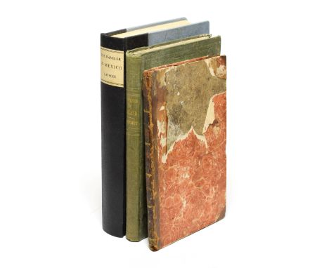
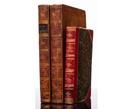
Bennett (William) Narrative of a Recent Journey of Six Weeks in Ireland, in Connexion with the Subject of Supplying Small Seed to some of the Remoter Districts ..., London; Charles Gilpin, John Hatchard, Dublin; J. Curry, 1847, original cloth (some damp staining); Makenzie (Mr.), The Man of Feeling, Cork; Edward Henry Morgan, 1803, half calf (worn); Latrobe (Charles Joseph), The Rambler in Mexico: 1834, Seeley & Burnside, 1836, folding map frontis, recent quarter cloth (3)

Lot 2104
Fox-hunting A List of the Bramham Moor Hounds from 1841 to 1892 and A List of the Bramham Moor Hounds from 1841 to 1904, two volumes, some damp-staining, all edges gilt, original limp leather bindings (worn) Pease, A.E., The Cleveland Hounds as a Trencher-Fed Pack, 1887, colour frontis, folding map, two folding facsimiles as called for, two Pease family bookplates to pastedown (overlaid), the upper possibly after Bewick, original cloth (3)


Lot 2116
Reynolds (Edward) Twenty Sermons Preached Upon Several Occasions, George Thomason, 1660, small quarto, twenty-two sermons, each with separate title and pagination, defective binding; Curwen (John F.), The Castles and Fortified Towers of Cumberland, Westmorland, and Lancashire North of the Sands. Kendal: 1913, original cloth; Wallace (W.), Alston Moor, 1890, original cloth (folding map torn with loss); Ingram (John H.), The Haunted Homes and Family Traditions of Great Britain, 1897, plates as called for, original pictorial cloth; with eleven others (15)
Lot 2122
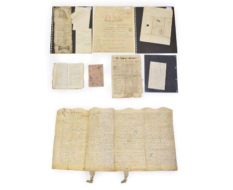
Evans (Cornelius) Cornelius Evans' Copy Book, 1804, containing recipes for whitening copper, how to make Japan ink, medicinal remedies, making dyes etc. etc., manuscript, marbled paper wraps; with a small quantity of others including a 1681 indenture, a French passport dated 1837 for David Roberts, an interesting letter from Corfu (1840) to David Roberts from his brother (with postmarks, a letter from Calcutta and a manuscript map of the Lucknow area, an 1867 letter signed by the Duke of Devonshire, Plato's Advice, a new Song, etc, (qty)

Lot 2123
Francklin (William) Military Memoirs of Mr George Thomas: Who, By extraordinary Talents and Enterprize, rose from an Obscure Situation to the Rank of A General in the Service of the Native Powers in the North-West of India ..., London; John Stockdale, 1805, Calcutta printed, frontis, folding map (torn & worn), plate, half calf (well worn, dust marked); Gregory (Olinthus), Lessons, Astronomical and Philosophical, for the Amusement and Instruction of British Youth ..., Conder, 1806, folding frontis, sheep (worn); The Youth Instructor and Guardian for 1824, (Vol 8), frontis, plates, includes account of Montserrat and Description of the Geysers in Iceland, calf (worn) (3)

Lot 518
JOHN SPEED (1552-1629 )The County of Warwick, engraved map, coloured, 16 x 21 in; an engraved, coloured map of Worcestershire by John Speed; A map of 'Herefordshire divided into hundreds' by Emanuel Bowen; together with a selection of other maps of Herefordshire and Worcestershire interest (9)


Lot 282
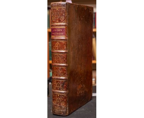
ANDERSON, George William - A New, Authentic, and Complete Collection of Voyages Round the World, Undertaken and Performed by Royal Authority.: Containing a New, Authentic, Entertaining, Instructive, Full, and Complete Historical Account of Captain Cook's First, Second, Third and Last Voyages : ...etc, eng. portrait frontispiece, double-page World map torn and defective, numerous plates and charts, full calf a little scuffed with short tear to lower hinge, folio, n.d c1780. * sold with all faults not subject to return


Lot 325
KELLY'S Directory of Devonshire: org. cloth, folding map, 4to, 1893. With - White, William, History, Gazetteer, and Directory of Devonshire : org. calf rubbed, 8vo, 1850. With - White, William, History, Gazetteer and Directory of the County of Devon, map, green cloth, thick 4to, 1878-9. (3)*Notes Facsimile reprint published in 1998 allegedly limited to 100 copies.
![KELLY, E. R [edit] The Post Office Directory of Devonshire : map, org. cloth, 4to, 1873.](https://cdn.globalauctionplatform.com/04b075f6-b7a7-4910-b1dc-ab6700dd8944/9b99c9fc-e85a-46db-86a7-ab6b0119e308/468x382.jpg)


Lot 363
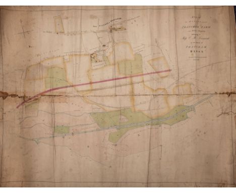
THATCHAM : Map of an Estate called Thatcham Farm and other property belonging to Miss C. M. Fromont in the Parish of Thatcham Berks. Surveyed & Drawn by F. W. Dibbin (Railway Engineers) large rolled manuscript map mounted on linen, with a fair bit of wear, 880 x 650 mm, 1837.*Notes Thatcham Estate belonged to the daughter of the proprietor of the first Mail Coach, Edward Fromont, the family were involved in the mail coach business until the coming of the railways. The railway is indicated on the plan by the surveyor F. W, Dibbin, a family member, who worked with I. K. Brunel. The Kennet and Avon Canal runs to the south of the estate.


![BLAEU, W & J - Candia, olim Creta [ Crete ] : uncoloured map, size 520 x 380 mm, c1650.](https://cdn.globalauctionplatform.com/04b075f6-b7a7-4910-b1dc-ab6700dd8944/e860a734-6f9e-49ff-936e-ab6b011a7772/468x382.jpg)


![KIP, William - Sussexia Siue Southsex, olim pars Regnorum [ Sussex ] : hand coloured map, size : 390 x 225 mm, f & g, c16](https://cdn.globalauctionplatform.com/04b075f6-b7a7-4910-b1dc-ab6700dd8944/c2158988-15fd-4c68-b5f8-ab6b011a7f82/468x382.jpg)


![SPEED, John : [Buckinghamshire] - hand coloured map with inset plans of Buckingham, and Reading, size : 500 x 380 mm, G. Humb](https://cdn.globalauctionplatform.com/04b075f6-b7a7-4910-b1dc-ab6700dd8944/e82a166d-8c30-4bef-af21-ab6b011a875d/468x382.jpg)
![VALK, G & SCHENK, P - Comitatus Darbiensis [Derbyshire] : hand coloured map, size 480 x 380 mm, paper age toned, f & g, early](https://cdn.globalauctionplatform.com/04b075f6-b7a7-4910-b1dc-ab6700dd8944/c6186867-f790-46ef-87ca-ab6b011a8a1b/468x382.jpg)


Lot 598
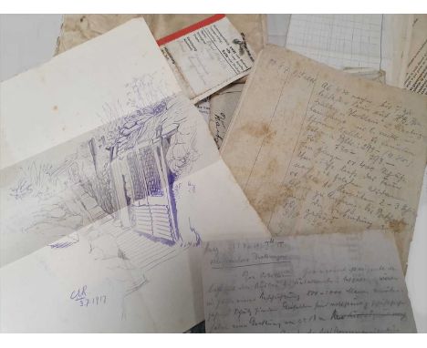
A collection of WW1 documents recovered from a dead German soldier at the Western front, 1917including sketch of the trenches, postcards, business card inscribed 'Walter Hundertmark', German military documents and papers including propaganda and calls for war bonds, name ticket and inscription describing the burial of the dead German soldier by the British and the body's location, map of "HeideKopf Nord" dated 30.9.16 map of Cambrai (1:25,000), letter in envelope and a diary of troop movements, last entry 23.10.17 together with a letter dropped by the Germans on Oct. 31st 1918 declaring armistice (qty)*Recovered by the later General Sir Miles Christoper Dempsey during his time as an infantry officer at the Western Front.
Lot 1113
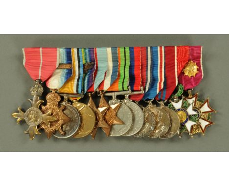
Military Interest and in particular Dieppe and D Day Landings Mulberry Harbour and Winston S. Churchill - Colonel Vassal Charles Steer-Webster OBE born 1896 an important archive including the following: signed photograph Winston S. Churchill VE Day 1945 with accompanying personal letter to Colonel Steer-Webster "Herewith copy of my Minute - Piers for use on beaches - and an autographed photograph of myself as a gesture of thanks to you for helping me to achieve it by your dedication to Mulberry". NOTE - Colonel Steer-Webster was in almost daily contact with Sir Winston Churchill during the construction and development of the Mulberry Harbours. Colonel Steer-Webster's medals and miniatures, including Order of The British Empire, World War One and World War Two medals, French Legion of Honour Medal and American Legion of Merit Medal. Both presented in A.H. Baldwin & Sons Limited presentation cases. Silver model of a "Concrete Mat" hallmarked London 1942, presented to Major V.C. Steer-Webster RE "As a tribute to his ingenuity and energy in discovering a simple solution to the baffling problem that made Dieppe possible, N.E. Wates and R.W. Wates December 1942". Length 14 cm. Colonel Steer-Webster was Deputy Director of Experimental Engineering and played a large part in the design of Mulberry B for Arromanches and previously designed concrete mats, "Chocolate Mattresses" to allow access to beaches with heavy artillery. Colonel Steer-Webster was awarded £1000 for his invention from "the Royal Commission on Awards". A silver plated model "Whale" (floating roadway), length 15 cm, and a silver plated model "Phoenix" anchorage point, length 14 cm. Both were important sections of the Mulberry Harbour. Colonel Vassal Charles Steer-Webster's Military OBE, cased. Colonel Vassal Charles Steer-Webster's "Freedom of The City of London" in later silver case dated October 1963, Garrard & Co. The Freedom of The City of London granted in 1951 "In Recognition of his achievements for having the Mulberry Harbours ready of D Day". Watercolour, Colonel V.C. Steer-Webster and black and white photographs of the same in military uniform. Approximately 150 black and white photographs of aspects of the Mulberry Harbour in construction and use, including official photographs. Tinted panoramic photographic view of Mulberry B 1944, 18 cm x 100 cm. Terence Cuneo Mulberry B 1944, 32 cm x 57 cm. Scrapbook "Mulberry Mission" to Canada 1946 comprising press cuttings and photographs, etc. The Mission was to allay misconceptions in Canada that the Canadian action at Dieppe was simply a tragic episode in the campaign, when in fact the action paved the way for the allies brilliant success in the D Day Landings of 1944. A case of 71 photographic slides in wooden case all Mulberry Harbour related, including design drawings and the harbour itself. World War One - Private V.C. Steer-Webster's dog tags, 1914 silver cigarette case, Royal Engineers cigarette lighter, 1914 Christmas tin, Victorian silver hip flask, Elliott Brothers pocket barometer, service books. The bullet that was removed from Private Steer after an injury which led to him being declared "no longer fit physically for war service" April 1916. There are numerous other items within the archive including lecture notes and in depth analysis of the D Day Landings and documentation from colonel Vassal Charles Steer-Webster's later career. There is also correspondence with the French Authorities in relation to his receipt of the French Legion of Honour Medal. A brief note on the importance of the Mulberry Harbours - the Mulberry Harbours were floating artificial harbours designed and constructed by British Military Engineers during World War Two. They were used to protect supply ships anchored off the coast of Normandy after the D Day Landings of June 6th 1944. The idea for such harbours came from several people and in particular Winston Churchill. The harbours were intended to protect the ships from storm and enemy attack. Many of the French ports had been destroyed and/or booby trapped by the Germans. The disastrous British attack on Dieppe in 1942 rekindled the interest in the artificial floating harbours. Two were built for D Day. Mulberry A was constructed off Omaha Beach to supply US forces. Mulberry B was built off Gold Beach at Arromanches to supply British and Canadian troops. Mulberry A was destroyed in a storm a few days after it was built. Mulberry B was operational for some 10 months after the landings. In the 10 months after D Day Mulberry B was used to land over 2.5 million troops, 500,000 vehicles and 4 million tons of supplies. The harbour is credited by some historians with shortening the war by increasing the effectiveness of the allied supply chain during the invasion. The harbours were a huge feat of civil engineering. They were built hastily in the dry docks on The Thames and Clyde. They were pulled across the channel by tugs and assembled off the French coast. They were operational within 12 days of the landings. The archive also includes a war time letter from Louis Mountbatten from South East Asia Command Headquarters August 1945 writing to "thank you for your great kindness in presenting me with a painting of Mulberry. I was informed of this just before I left London recently but owing to the Japanese surrender I had to leave so quickly that I was unable to write at the time and thank you". There is also a signed letter from Winston Churchill dated 24th April 1945 thanking Colonel Steer-Webster for "the excellent coloured reproduction of Mulberry B which you have been good enough to have prepared for me" and "thanking you for the various models and relief map of the Mulberry which you have sent to my map room during the past months". There is a secret movement order to Steer-Webster and in reference to Juno Beach June 1944 and other wartime orders (see illustration).


Lot 358
A FAIRBAIRN SYKES TYPE COMMANDO DAGGER by William Rodgers of Sheffield, with 6 3/8" double edged blade, cross guard stamped with maker's mark, ribbed brass grip and leather sheath with frog, 13" overall, together with an end of war 1914-1918 Yser Guide/Panorama map (2) (Est. plus 21% premium inc. VAT)


-
109182 item(s)/page