We found 109182 price guide item(s) matching your search
There are 109182 lots that match your search criteria. Subscribe now to get instant access to the full price guide service.
Click here to subscribe- List
- Grid
-
109182 item(s)/page


Lot 503
"WILLIAM HOLE (d.circa 1624)’A Description of the Land of Goshenand Moses passage thro the deserts’engraved map, coloured,10 1/2 x 14 in (26.7 x 35.6cm)sold with an engraved map by J. Covens and C. Mortier, ‘Carte d’Une partie de la Chine, les iles Phillipines, de La Sonde, Moluques, de Papoesi & c, Amsterdam, 1720; heightened with colour; two (2)"


Lot 505
"PHILIPPUS BRIET (1601-1668)Roma Gentium Dominaengraving, c. 1650Pl. 14 3/4 x 21 3/4 in (38 x 55 in);an engraved map by William Blaeu depicting Sabaudia Ducatus/Savoye c. 1635;and an engraved map by William Fadendepicting ‘A Map of the United Provinceswith the Land of Orent and the Generality Lands’. (London) 1789; three (3)"


Lot 507
"EMMANUEL BOWEN (1694-1767)’An Accurate Map of HerefordshireDivided Into Its Hundreds’engraving, heightened with colour(London) 175521 x 28 1/4 in (53.5 x 72 cm);a map of Herefordshire byWilliam Hole (after Christopher Saxton)titled ‘Frugiferi ac Ameni Herefordiae Comitatus’;and a map of Herefordshire by Robert Morden; three (3)"

Lot 508
"JOHN SPEED (1552-1629)The Kingdom of Great Britain and Ireland, engraved map, later coloured, with english text verso, London, J. Sudbury and George Humble, 14 1/2 x 20 in; and John Speede, The Kingdom of Scotland, engraved map, double page , coloured, latin text verso, 14 1/2 x 20 in; two (2)"

Lot 509
"JOHN SPEED (1552-1629)’Shropshire described, the sittuation (sic) of Shrewsbury shewed’, engraved map, hand coloured, double page, english text verso, London, John Sudbury and George Humble, 1616; sold together with a selection of other maps including ‘Herefordshire’ ; ‘Merioneth described 1610’; ‘the Countye of Monmouth with the sittuation of the shire-towne described Ann. 1610’ ;and ‘The County of Monmouth ‘ by Robert Morden (qty)"

Lot 510
"JOHN SPEED.(1552-1629) ‘Oxfordshire Described with ye citie and the Armes of the Colledges of yt famous University ao 1605’, engraved map, hand coloured , with English text verso depicting the County, its history and features, John Sudbury and George Humble 1646; two other maps by Speed depicting Cambridgshire (publ.1676) and Pembrokeshire; an engraved map of Surrey by Johannes Norden; and Cornwall by Christopher Saxton/Kip; five (5)"


Lot 512
"JOHN SPEED(1552-1629) ‘Herefordshire described with the true plot of the Citie of Hereford as also the Armes of thos nobles that have been intituled with that dignity,’ engraved map byJodocius Hondius, latin text edition, London, John Sudbury and George Humble , 1616, 14 3.4 x 20 in This example comes from the only non-English edition of Speed’s ‘theatre’ produced for the continental market Sold together with an unframed engraved map (in four sections) by Isaac Taylor titled ‘This New map of the County of Hereford’; four unframed engravings depicting Views of Hereford Cathedral by S. Middiman and F. Jukes (after Jame Wathen); ‘The North east prospect of the City of Hereford’ by Samuel and Nathaniel Buck; and ‘An Accurate Map of the County of Hereford’ by Emanuel Bowen (qty)"

Lot 513
"JOHN SPEED(1552-1629) ‘Herefordshire described with the true plot of the Citie of Hereford as alsoe the Armes of those nobles that have been intituled with that dignity’, engraved map, with later colouring, english text verso, published 1676, Thomas Bassett and Richard Chiswell, 14 3/4 in x 20 in; sold with a miscellaneous selection of other maps (qty)"


Lot 709
A collection of 18th and 19th century topographical engravings, etc, including a large early 19th century coloured engraving by T Hollins - A View of the High Street, Birmingham, with numerous figures, mail coach, etc, 56 x 77 cm in Hogarth type black and gilt frame, two black and white engravings after Kip showing Little Compton, the seat of Sir Richard Howle Baronet, 35 x 43 cm, and Badminton, seat of Prince Henry, Duke of Beaufort, an 18th century map of Dorset showing the road from Bristol to Weymouth, 19 x 12 cm, an etching showing St Martin's Church, London, signed in pencil W M Little (?), etc (all framed)


Lot 771
A facsimile copy of an 1830 map showing the Severn Estuary with printed inscription Published AT The Tower of London 1830 by Lieutenant Colonel Colby of the Royal Engineers, with publication details verso, 65 x 79 cm in simple black frame together with two marquetry pictures by G Norton, one showing The Landgate at Rye, inscribed and dated verso 1977, the other showing Godshill Isle of Wight and dated 1976 together with a further marquetry panel, probably by the same hand, showing a three masted sailing ship, various sizes maximum 48 x 40 cm, also together with a watercolour illustration of dinosaurs, 14 x 22 cm


Lot 795
2 WWII British leaflets that were dropped on German troops, “Is it your turn now?” and “Bist Du an Der Reihe”, used in the Monte Cassino area; a 1944 War Office map of Paderborn Area; a British soldier’s passbook; 2 other books and Eisenhower’s message to the troops leaflet. QGC (some wear and tears)
Lot 466
A 1945 French Corps Expeditionnaire (Indo China) enamelled badge, map in shield on anchor, brooch pin; a WWII French “Jedburgh” team badge (adapted from British Parachute Regt WM cap badge); 8 WWI French cloth sidecap badges: 3rd, 150th Infantry (3 varieties), 25th, 61st, 156th and 163rd Art. GC -10


Lot 488
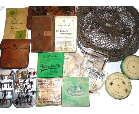
ACCESSORIES: (Qty) Alfred Ronalds Fly Fishers Entomology, 6th edition, canvas cover light foxing to front & rear pages, Wheatley alloy clip fly box 6" x4" holding various tradition steel eyed salmon flies, The Pull Out Patent pigskin cast wallet with contents, various casts in packets by Farlow, Pilot Tisdale new Zealand in Farlow and Ogden Smith boxes, box of old dapping flies, The BFSC linen foldout map of the Fishing Stations of Scotland, cast containers, early keep net etc.

Lot 603
Lumley & Dowell - "Norwegian Anglings" 1st ed 1907, paper covered H/b, some chips and grubby, fold out colour map to front, 238 pages, internally clean and Lumley & Dowell - "Norwegian Anglings" 1st ed 1914, loose on spine, chips to spine and edges, fold out map, interesting reading and great adverts. (2)


-
109182 item(s)/page