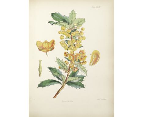

HOOKER (JAMES DALTON)The Botany of the Antarctic Voyage of H.M.S. Ships Erebus and Terror in the Years 1839-1843, under the Command of Captain Sir James Clark Ross, 2 vol. ['Flora Antarctica'], FIRST EDITION, wood-engraved illustration on titles (both dated 1847), hand-coloured lithographed map, 187 hand-coloured lithographed plates (nos. 1-198, 107bis and 107ter, on 187 sheets, 13 double-page), tissue guards, later half morocco gilt, t.e.g., rubbed at extremities, joints restored [Ferguson 3840; Great Flower Books, p.101; Nissen BBI 908; Rosove 172.A1; Stafleu TL2 2964], 4to (310 x 240mm.), Reeve, Brothers [1844]-1847Footnotes:THE SCARCE FLORA ANTARCTICA was the first of Hooker's publications resulting from the important four-year expedition to the southern oceans led by James Clark Ross between 1839-1843. Joseph Hooker, whose father William was the first director of the Royal Botanic Gardens at Kew, was assistant surgeon aboard Erebus, his sojourns ashore allowing him 'to collect plants in relatively unexplored regions. Before Hooker set sail Charles Lyell of Kinnordy (father of the geologist) had given him the proofs of Charles Darwin's Voyage of the Beagle, which he read eagerly' (ODNB), inspiring his scientific and botanical endeavours. On his return he was able to publish his reports with the support of an Admiralty grant of £1,000 to pay for the printing of the plates. This copy has both title-pages dated 1847, the title to volume 1 usually dated 1844. Two further publications on the flora of New Zealand, and of Tasmania were published between 1851-1859.Provenance: W.L. Foster, bookplate.This lot is subject to the following lot symbols: •• Zero rated for VAT, no VAT will be added to the Hammer Price or the Buyer's Premium.For further information on this lot please visit Bonhams.com
We found 109182 price guide item(s) matching your search
There are 109182 lots that match your search criteria. Subscribe now to get instant access to the full price guide service.
Click here to subscribe- List
- Grid
-
109182 item(s)/page
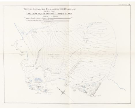
DEBENHAM (FRANK)British (Terra Nova) Antarctic Expedition 1910-1913. Report on the Maps and Surveys, FIRST EDITION, 15 folding maps, EXTRA-ILLUSTRATED WITH 2 COPIES OF 'THE SOUTH POLAR CHART' (issued by the Admiralty, 1926, one annotated in coloured pencils), all loose as issued in pocket at end, publisher's cloth, spine and sides faded [Conrad, p.174; Renard 186; Rosove 293-10.A1; Spence 357], 4to, Harrison and Son, for the Committee of the Captain Scott Antarctic Fund, 1913Footnotes:Important report from Captain Scott's British (Terra Nova) Antarctic Expedition 1910-1913. One of Debenham's 'most significant contributions to the work of the expedition... was his expertise in plane-table mapping. He convinced Scott and other members of the expedition of its value not only at base camps but also on sledge journeys' (ODNB), and he used his cartographic expertise to complete these charts, still in use in the late 1950s. 'His map-making skills are best displayed in this publication' (Taurus).This copy includes 2 copies of the large 'South Polar Chart' (sheet 672 x 865mm.) published by the Admiralty. First issued in 1887, these are updated with 'amendments and additions to 1926', including the routes of Scott and Amundsen. One of the maps is annotated in coloured pencil.Provenance: Dept. of External Affairs, New Zealand, stamp on front free endpaper, and gilt shelf marks on spine, and stamp on verso of Polar chart.This lot is subject to the following lot symbols: •• Zero rated for VAT, no VAT will be added to the Hammer Price or the Buyer's Premium.For further information on this lot please visit Bonhams.com
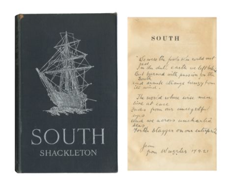
SHACKLETON (ERNEST HENRY)South. The Story of Shackleton's Last Expedition 1914-1917, fourth impression, INSCRIBED BY FRANK A. WORSLEY WITH A POIGNANT TRANSCRIPTION OF ONE OF SHACKLETON'S FAVOURITE POEMS, TO HIS FUTURE WIFE ('Jean from Wuzzles 19.9.21') on the half-title, colour frontispiece of the 'Endurance', 88 plates (mostly photographic by Frank Hurley, one near loose), large folding map (tear repaired in blank inner margin), illustrations, maps and diagrams in the text, small burn hold to pp.145/6 touching a few letters, publisher's pictorial blue boards cloth, with image of 'Endurance' and lettering in silver gilt, rubbed at extremities of spine, hinges starting [cf.Conrad, p.224; cf.Spence 1107; Taurus cf.105], 8vo, William Heinemann, [March] 1920Footnotes:A FINE ASSOCIATION COPY INSCRIBED BY SHACKLETON'S COMPANION FRANK WORSLEY, CAPTAIN OF THE ENDURANCE TO HIS FUTURE WIFE, QUOTING A ONE OF SHACKLETON'S FAVOURITE POEMS - 'We were the fools who could not rest... But burned with passion for the South, and drank strange frenzy from its wind...'.Frank Worsley, as the captain of the Endurance, had a crucial role in the survival of all the expedition members. After the ship was crushed in the ice he navigated the crew to safety on Elephant Island, then, in the company of Shackleton and four companions 'embarked upon the epic voyage of 800 miles in the Caird, a 22 foot boat, across the Southern Ocean in some of the stormiest seas in the world, landing at Cape Rosa in South Georgia on 10 May' (ODNB). Worsley, Shackleton, and Crean then crossed the previously unclimbed Allardyce Range to the far side of the island, to reach the whaling stations on the far side of the island. Worsley subsequently served under Shackleton whilst providing provisions to the northern Russian front, and as captain of the Quest, confirmation of the high esteem each man had for the other.The 2-stanza poem, 'We were the fools...', which Worsley writes out, was a favourite of Shackleton. On 5 December 1914, 'as Endurance sailed from South Georgia... [Shackleton] wrote in his diary the first verse of a poem by St John Lucas called The Ship of Fools' (James Caird Society, Newsletter 13, Summer 2019).Provenance: Gift inscription from Frank Worsley (1872-1943) to his future wife Jean Cuming (1900-1978). Having met in 1919 they married in 1926; Pat Bamford, in whose house in Claygate, Surrey both Frank and Jean lived until their respective deaths; by family descent to current vendor.This lot is subject to the following lot symbols: •• Zero rated for VAT, no VAT will be added to the Hammer Price or the Buyer's Premium.For further information on this lot please visit Bonhams.com
![[SHACKLETON (ERNEST HENRY)]WORSLEY (FRANK A.) The final portion of his archive relating to his polar explorations with Shackl](https://cdn.globalauctionplatform.com/fcb7c648-6687-46c1-b355-ae3200ae8b5d/d3d03d82-2a65-4df1-8b4a-ae3200b1d7b4/468x382.jpg)
[SHACKLETON (ERNEST HENRY)]WORSLEY (FRANK A.) The final portion of his archive relating to his polar explorations with Shackleton (Endurance and Quest), and career, including signed copies of his books, corrected typescripts, manuscript notes for lectures and articles, and photographs, including:BOOKS, ALL PRESENTATION COPIES FROM WORSLEY: Under Sail in the Frozen North, inscribed 'To my Jean with love from Wuzzles 1.2.27', ORIGINAL PEN AND INK MAP by Worsley for illustration used opposite p.123 in book loosely inserted, Stanley Paul, [1927]; Endurance. An Epic of Polar Adventure, inscribed 'To my Jean from Wuzzles, 18th March 1931', dust-jacket (defective), Philip Allan, 1931; First Voyage in a Rigged Ship, inscribed 'To my sweetheart Jean from her Wuzzles, 29th Aug. 1938', dust-jacket (some small losses), Geoffrey Bles, [1938]; Shackleton's Boat Journey, inscribed 'Pat Bamford from F.A. Worsley, Hodder & Stoughton, [1940], all publisher's cloth, 8vo; Shackleton's Last Expedition. Southward on the Quest, inscribed 'Jean from Wuzzles: Xmas 1923' on the upper wrapper, 8 photogravure plates, publisher's wrappers (some losses at margins and spine, old tear on upper cover), oblong folio, [?1923]MANUSCRIPTS: Heavily annotated typescript manuscript of Worsley's book 'First Voyage in a Rigged Ship', approximately 400pp., printed verso only, with numerous corrections throughout, disbound, 4to, [c.1938]; 'Adventure' [autobiographical essay recalling Shackleton, etc.], manuscript, 9pp., purple pencil on lined paper, 4to (230 x 18omm.) [c.1940]; 'The Lure of the Poles', manuscript, 5pp., black ink on lined paper, folio (330 x 200mm.); Two incomplete manuscript essays, approximately 20pp.; Three typescript manuscripts ('Sunset to Sunset in the Artic', 'Bear Steaks', 'Polar Asunder'), together 20pp., address and a few corrections, the second with proofing corrections in an another hand, various sizes.EPHEMERA AND OTHER: Ink sketch by Worsley (signed 'F.A.W.' of the rigging and sails of an unidentified ship, 230 x 65mm.; [QUEST] Manuscript receipt, 'Recieved from Commander F.A. Worsley the sum of eight pounds to be expended on behalf of the Tristan da Cunha people in stores... Cape Town', 1 page, 8vo, 29 June 1922; Watercolour of a large unidentified ship with three masts, 180 x 265mm., signed 'Th. Gaede, 1921'; Documents relating the 'Frozen North' expeditions and ship 'Iceland', one signed by the expedition leader Grettir Algarsson; Official documents relating to Worsley's enlistment for action in both the First and Second World Wars; Chief Officer's Log Book for a voyage undertaken by the Steam Yacht 'Calamara', under the command of Worsley, 24 pages, printed with manuscript entries (and a few marginal sketches), most pages signed off by Worsley and the chief officer, loose, frayed at edges, folio (390 x 330mm.), [1937]; 'Ode to Eric' by Worsley, typescript poem addressed to his friend Eric Bamford signed 'Wuzzles. Poet 14th Oct. 1941'; correspondence and papers relating to Worsley's book contracts, and involvement in the the film 'Endurance', including invitations to luncheons to celebrate the film launch; small group of personal papers, including marriage certificate; Worsley's copy of 'How to Make Knots, Bends and Splices, As Used at Sea'PHOTOGRAPHS: A collection of approximately 23 photographs of Worsley at various stages of life, in uniform, on ships, with his wife, etc., with a few others, one a postcard photo of 'The Endurance' in the pack ice, mostly vintage gelatin silver, 45 x 95mm., and smaller, [various dates] (quantity)Footnotes:'THE GREATEST ADVENTURES HAVE BEEN CARRIED OUT BY NUMBERS OF MEN WORKING TOGETHER AIDED BY TEAMWORK, LOYALTY AND FRIENDSHIP AS EVEN SHACKLETON ALONE COULD NOT HAVE CARRIED OUT THE HISTORIC BOAT JOURNEY FROM ELEPHANT ISLAND TO SOUTH GEORGIA...' - The remaining archive of Frank A. Worsley (1872-1943), a key figure in the 'Heroic age of Polar exploration', who accompanied Shackleton as his Commander on the Endurance, and helping navigate the James Caird during the Imperial Trans-Antarctic Expdition 1914-1916. He was also on the Shackleton–Rowett Expedition of 1922, noting in the manuscript essay 'Adventure' (included in this lot) 'I was with him when he died in the Quest. I lost a true friend and England lost a great adventorous man'. The archive includes manuscript, printed, and photographic materials relating to his Polar adventures, but also actions in both wars, the North Russian seas, the Carribean where he led a hunt for treasure alongside his wife in the 1930s, and his involvement with promoting the film of Endurance, 1919. After Jean's death the Bamford family donated Worsley's diaries, medals and other materials to the Scott Polar Institute, and the Akaroa Museum in New Zealand, but these poignant materials have remained with the Bamford family.Provenance: Bequeathed by Worsley to his wife Jean (née Cuming, 1900-1978). Having met in 1919 they married in 1926; Pat Bamford, in whose house in Claygate, Surrey both Frank and Jean lived until their respective deaths; by family descent to current vendor.For further information on this lot please visit Bonhams.com

ASIA - MAPBLAEU (WILLEM) Asia noviter delineata, hand-coloured engraved map, 9 city views and plans (Candy, Calecut, Goa, Damascus, Jerusalem, Hormuz, Banten, Aden and Macao) in upper margin, 10 costume vignettes in horizontal margins, decorative cartouche flanked by 2 Tartars, embellished with ships, a sea creature, and various animals, good margins, 515 x 555mm., [Amsterdam, c.1635]This lot is subject to the following lot symbols: •• Zero rated for VAT, no VAT will be added to the Hammer Price or the Buyer's Premium.For further information on this lot please visit Bonhams.com

DORN (FRANK)A Map and History of Peiping; formerly known as Peking, large chromolithographed map of Peking, framed and glazed, sheet to view 850 x 735mm., Tientsin-Peiping, Peiyang Press Ltd., 1936Footnotes:HIGHLY DECORATIVE MAP OF BEIJING, depicting the principal sites and occupations of the inhabitants of the city, within a pictographic border showing Chinese history, the whole enlivened with amusing vignettes of the everyday life and sights of the city.This lot is subject to the following lot symbols: •• Zero rated for VAT, no VAT will be added to the Hammer Price or the Buyer's Premium.For further information on this lot please visit Bonhams.com
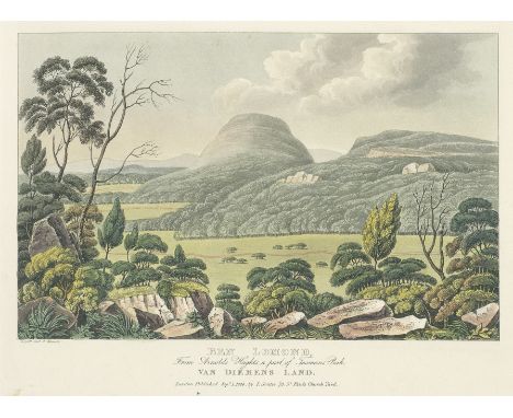
LYCETT (JOSEPH)'Ben Lomond, from Arnolds Heights, a part of Tasman's Pea, Van Diemens Land'; 'Mount Direction, near Hobart's Town, Van Diemens Land'; 'View of Tasman's Peak, from Macquarie Plains'; 'Western or Boundary Lake, Van Diemens Land'; 'Cape Pillar, near the Entrance of the River Derwent, Van Diemen's Land', from 'Views in Australia or New South Wales, & Van Dieman's Land Delineated...', hand-coloured engraved views, old dealer stamp on verso, platemark 240 x 330mm., 1824--LE BRETON (LOUISE) Vue d'Hobart prise de la Pointe Kangorou, hand-coloured lithograph by P. Blanchard after Le Breton, image 205 x 340mm., Paris, Gide, [c.1841]--LAURIE & WHITTLE, publishers. A Chart of Van Diemen's Land, the South Extremity of New Holland, with the New Discovered River by the Ships Duke and Duchess. From Captn. John Hayes, hand-coloured engraved map, inset view of the 'Continuation of the River from King George's Bay...', 580 x 690mm., 1798--JOHNSTONE (A.K.) Van Diemen's Land or Tasmania, hand-coloured engraved map hand-coloured in outline, 645 x 550mm., [c.1844]; and 17 others, including 16 nineteenth-century maps (mostly hand-coloured in outline) of Tasmania, or Australia, and one print (25)For further information on this lot please visit Bonhams.com
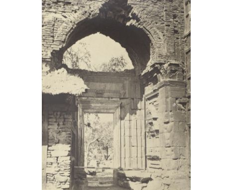
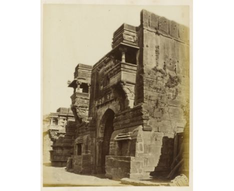
KASHMIRCOLE (HENRY HARDY) Illustrations of Ancient Buildings in Kashmir. Prepared under the Authority of the Secretary of State for India in Council from Photographs, Plans and Drawings taken by Order of the Government of India, 43 mounted carbon autotype prints (numbered 1-44), lithographed map and 13 plates (only, of 14), light foxing to plates and margins of photographs, one or two tears at edges, modern half calf gilt, matching slipcase [cf. Gernsheim, Incunabula 485, recording 2 editions of that year], folio (325 x 230mm.), W.H. Allen for the India Museum, 1869Footnotes:The fine photographs were taken by John Burke (1843-1900), a commercial photographer operating from Murree and Peshawar. He accompanied, alongside two 'native surveyors, Thakoor Dass and Habeeb-oo-lah', Cole's expedition to the Kashmir Valley in October 1868 to survey the great pre-Islamic temples scattered through the region.Provenance: Kanwardip Gujral; his sale, Bonhams, 9 April 2008, lot 18.This lot is subject to the following lot symbols: •• Zero rated for VAT, no VAT will be added to the Hammer Price or the Buyer's Premium.For further information on this lot please visit Bonhams.com
KASHMIRCOLE (HENRY HARDY) Illustrations of Ancient Buildings in Kashmir. Prepared under the Authority of the Secretary of State for India in Council from Photographs, Plans and Drawings taken by Order of the Government of India, FIRST EDITION, 43 mounted carbon autotype prints (numbered 1-44), 14 plates, one colour-printed lithographed map ('Skeleton Map of Kashmir', detached with small tear) by W. Griggs after Cole, 8 gelatin silver prints by the Archaeological Photo Works of India tipped-in, occasional foxing, title blindstamped and repaired at edges, blank section cut from author's Notice, plates loose, chipped and torn with very occasional loss to text, modern blue calf gilt [cf. Gernsheim 485, recording 2 editions of that year], folio (325 x 215mm.), W.H. Allen, Publishers to the India Museum, 1869Footnotes:Provenance: Kanwardip Gujral; his sale, Bonhams, 9 April 2008, lot 19.This lot is subject to the following lot symbols: •• Zero rated for VAT, no VAT will be added to the Hammer Price or the Buyer's Premium.For further information on this lot please visit Bonhams.com
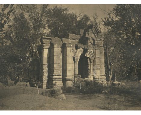
BURGESS (JAMES)Archaeological Survey of Western India. Report on the Antiquities of Kathiawad and Kachh, Being the Result of the Second Season's Operations of the Archaeological Survey... 1874-75, FIRST EDITION, 33 albumen prints mounted, and additional sequence of 29 albumen prints, folding chromolithographed map (split at fold), 40 lithographed plates, occasional foxing, contemporary half morocco, rubbed, 4to, India Museum, 1876Footnotes:The final leaf of text lists 29 'extra Photographs illustrative of this Report [which] are not published, but the negatives are deposited at the India Office.' The present copy includes this additional suite of images.Provenance: Kanwardip Gujral; his sale, Bonhams, 9 April 2008, lot 13.This lot is subject to the following lot symbols: •• Zero rated for VAT, no VAT will be added to the Hammer Price or the Buyer's Premium.For further information on this lot please visit Bonhams.com


Ɵ LIEUTAUD, M.CONNOISSANCE DES TEMPS POUR LE ANEE 1707,Par l'ordre de l'Academie Royale des Sciences, et calcule'e Par M. Lieutaud, de la meme Academie Jean Boudour, Paris 1706, engraved frontispiece, 187 pages including numerous tables with celestial chart after page 120, map of the moon after page 160 and map of France after page 162, vellum titled in ink to spine, 8vo.


France, UK and Europe Maps 1766 - 1983 Includes Hand-Coloured French Map of Northern Italy published in Dijon 1766 some water staining 24cm x 16.5cm, French Map of Central and Southern Italy published in Dijon 1766 35cm x 25cm, Map of London, Chatham and Dover showing branches of the Metropolitan Extension Lines in red with dotted lines for as yet unopened lines including Bromley, Flamborough, Maidstone, on reverse showing Map of Continental Railways and UK connections, British Railways Map of Great Britain 1949, British Rail Passenger Network Map 1982-83, see Images good condition. We combine postage on multiple winning lots and can ship worldwide. UK postage from £4.99, EU from £6.99, Rest of World from £8.99

Americas. Bertius (Petrus & Tavernier Melchior). Carte de l'Amerique corrigée, et augmentée dessus toutes les aultres cy devant faictes par P. Bertius, 1661, uncoloured engraved map, with two inset maps of the polar regions, slight staining, 275 x 365 mmQty: (1)Footnote: A later state of the Bertius/Tavernier map of 1627, which in turn was based upon Hondius's seminal map of the Americas. This example lacks all the additional embellishments of Galleons and sea monsters. Smaller than the original Bertius map, this example was published in Pierre d'Avity's "Description Generale de l'Amerique" Rare. P. Burden. The Mapping of North America, no.256, state 3.

Americas. Speed (John), America with those known parts in that unknowne worlde, both people and manner of Buildings. Discribed and inlarged by J. S. Ano. 1626, George Humble, circa 1627, hand-coloured engraved carte-a-figure map, 6 (only) costumed figures to the vertical margins and eight oval vignettes of principal cities along the upper margin, inset map of Greenland, insular California, central fold and margins strengthened and reinforced on the verso, right-hand margin trimmed and lacking four off the five costumed figures in the right-hand vertical border, margins replaced in facsimile, 390 x 510 mm, English text on verso, framed and double-glazed Qty: (1)

Americas. Speed (John), America with those known parts in that unknowne worlde, both people and manner of Buildings. Discribed and inlarged by J. S. Ano. 1626, George Humble, circa 1627, uncoloured engraved carte-a-figure map, 10 costumed figures to the vertical margins and eight oval vignettes of principal cities along the upper margin, inset map of Greenland, insular California, thread margins to three borders, central fold with slight creasing and skilfully strengthened on the verso, small areas of restoration to the lower corners, skilful restoration in facsimile to the title and the image of the 'Magellanican' in the lower right corner, slight creasing, 390 x 510 mm, English text on versoQty: (1)


Berkshire. Blaeu (Johannes), Bercheria vernacule Barkshire, Amsterdam, circa 1660, engraved map with contemporary hand-colouring, some adhesion scaring and surface abrasion affecting the printed surface, 385 cx 500 mm, Spanish text on verso, together with Bowen (Emanuel). An Accurate Map of Berkshire, Divided into its Hundreds..., Carington Bowles and R. Sayer, 1756, engraved map with contemporary hand colouring and some later enhancement540 x 700 mm, mounted, framed and glazedQty: (2)

Bickham (George). A Map of Surrey. West from London, A Map of Wiltshire West from London, A Map of Sussex South from London [and] A Map of Somerset Shire West from London, 1751, together four uncoloured aerial and allegorical projections of each county, with title and descriptive text at the head and foot of each map, each map supplied with 3 or 4 pages of descriptive text, each approximately 255 x 155 mmQty: (4)Footnote: Originally published in 'The British Monarchy or a Chorographical Description of all the Dominions Subject to the King of Great Britain', published in 25 parts between 1743 and 1754
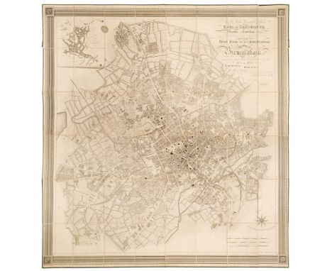
Birmingham. Beilby, Knott & Beilby (publishers), To the Right Honourable William Earl of Dartmouth, Viscount Lewisham &c. &c. the Zealous Promoter of the interests of the Town and Liberal Patron of its Public Institutions, This Map of Birmingham engraved from a minute Trigonometrical survey, made in the years 1824 & 1825, is with permission dedicated..., J. Pigott Smith, Surveyor and Engineer, Birmingham, March 25th 1828, uncoloured large engraved map, sectionalised and laid on linen, inset plan of the town of Birmingham in the year 1731, large calligraphic cartouche, compass rose and mileage scale, slight dust soiling, edged in green silk which is partially frayed, 1380 x 1290 mm, marbled endpapers, Qty: (1)Footnote: A scarce large scale map of Birmingham.
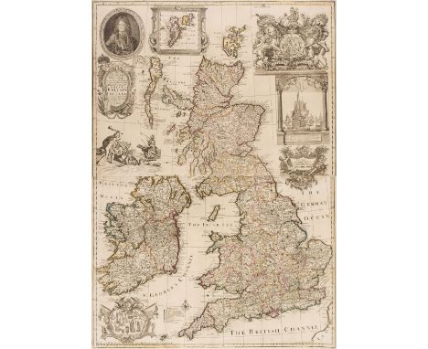
![British Isles. Jansson (Jan & Hondius Henricus), Magnae Britanniae et Hiberniae Tabula, 1631 [but 1636 edition], hand-col](https://cdn.globalauctionplatform.com/0b58d581-ebd7-4ad4-9c12-ae4000b9ea0d/cf131848-546a-44f8-b5a1-ae4001048f1a/468x382.jpg)
British Isles. Jansson (Jan & Hondius Henricus), Magnae Britanniae et Hiberniae Tabula, 1631 [but 1636 edition], hand-coloured engraved map, inset map of the Orkney Islands, decorative cartouche and mileage scale, central fold strengthened on verso, 380 x 510 mm, English text on versoQty: (1)Footnote: R. W. Shirley. Early Printed Maps of the British Isles, 1477 - 1650, no. 435.

Gaudry (Albert). Recherchesscientifiquesen orient entreprises par les ordres du gouvernement, pendant les années 1853-1854, 1st edition, Paris: Imprimerie impériale, 1855, inscribed by the author to upper margin of half-title, 8 lithographs (1 hand-coloured), large folding map of Cyprus, ex-library, spotting (mostly to margins), gilt turn-ins with foliate embellishments, contemporary red morocco, spine in 5 compartments separated by raised bands, spine lettered in gilt, compartments and boards bordered in gilt, all edges gilt, joints worn, library sticker to base of spine, extremities rubbed, boards marked, 8voQty: (1)
British Isles. Jansson (Jan), Britannia prout divisa temporibus Anglo-Saxonum praesertim durante illorum Heptarchia, [1646 or later], engraved map with contemporary hand-colouring, fourteen inset panels of Saxon kings and historical scenes, elaborate cartouche, compass rose and numerous rhumb lines, slight staining, 420 x 520 mm, German text on versoQty: (1)Footnote: R. W. Shirley. Early Printed Maps of the British Isles 1477 - 1650, no. 577.
![British Isles. Ruscelli (Girolamo Ptolomy Claudius), Tabula Europae I, Venice, [1561 - 64], uncoloured Ptolemaic map of the B](https://cdn.globalauctionplatform.com/0b58d581-ebd7-4ad4-9c12-ae4000b9ea0d/288c6911-add2-416b-8bc4-ae400104915e/468x382.jpg)
British Isles. Ruscelli (Girolamo Ptolomy Claudius), Tabula Europae I, Venice, [1561 - 64], uncoloured Ptolemaic map of the British Isles on a trapezoidal projection, slight finger soiling in the margins, 190 x 260 mm, Italian text on versoQty: (1)Footnote: R. W. Shirley. Early Printed Maps of the British Isles 1477 - 1650, no. 67
![British Isles. Ruscelli (Girolamo), Anglia et Hibernia Nova, Venice [1561], uncoloured engraved map,190 x 260 mm, Italian tex](https://cdn.globalauctionplatform.com/0b58d581-ebd7-4ad4-9c12-ae4000b9ea0d/6aaa1932-e4e9-4bc7-8ed7-ae4001049206/468x382.jpg)
British Isles. Willdey (George), To his sacred and most excellent Majesty George by the Grace of God King of Great Britain, France & Ireland &c. This map of Great Britain and Ireland corrected from the newest & most exact observations is most humbly dedicated by your Majesty's loyal and most obedient subject and Servant George Willdey, Made & Sold by George Willdey at ye Corner House in Ludgate Street next St. Pauls,1715, engraved map on two conjoined sheets with contemporary outline colouring, inset map of the Shetland Islands, and an oval portrait of George I, an allegorical scene of Hercules defeating the Hydra, a large royal coat of arms and an advertisement for the wares sold in George Willdey's shop to the lower-left corner, with a maritime vignette displayed within a classical border, old folds with some professional restoration to the vertical margins and folds, 960 x 655 mm Qty: (1)Footnote: R. W. Shirley. Printed Maps of the British Isles 1650 - 1750. Willdey 2. Uncommon.

Cardiganshire. Speed (John), Cardigan Shire Described with the due forme of the Shiretown as it was surveyed by J. S...., [1616], uncoloured engraved map, inset town plan of Cardigan, slight text show through, 385 x 505 mm, Latin text on verso, together with another later edition, published in circa 1743 by Henry Overton, with sparse outline colouring, some creasing, no text on versoQty: (2)
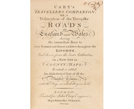
Cary (John). Cary's Traveller's Companion, or, A Delineation of the Turnpike Roads of England and Wales..., 1791, calligraphic title with near-contemporary manuscript signature, advertisement and contents list, 43 (of 44, lacking Yorkshire), engraved maps with contemporary outline colouring, printed back-to-back, some staining and dust soiling throughout, list of market and borough towns and an advertisement bound at rear, modern ink ownership signature to front endpaper, hinges and joints weak and cracked, upper board near detached, contemporary half calf, rubbed and worn, 8vo, together with Law (James Thos.). A New Set of Diocesan Maps, Lichfield Theological School,1864, 27 colour lithographic double-page maps, the maps of Exeter folding with some marginal fraying and slight loss to the printed surface, some staining and spotting throughout, upper hinge broken, publisher's boards with printed title to the upper cover, boards heavily worn and frayed, lacking spine, folio, with Heywood (John). The Travelling Atlas of England & Wales with all the Railways & Coach Roads, The Cities, Towns, Parks & Gentlemen's Seats..., Manchester 1868, decorative calligraphic title, folding map of England & Wales and 44 (complete) uncoloured lithographic maps of English counties, printed back-to-back, some dust soiling, publisher's printed paper wrappers with near-contemporary ownership signature to upper cover, wrappers heavily worn, frayed and soiled, slim 8voQty: (3)Footnote: Sold as a collection of maps, not subject to return.
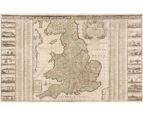
England & Wales. Willdey (George), A New & Correct Map of England & Wales now called South Britain, done from the latest surveys and best observations. Containing all ye cities & Market Towns with ye roads & distance in reputed miles between Town & Town by inspection without scale or compass..., circa 1717, engraved map with contemporary outline colouring on two conjoined sheets, tables of towns and cities and eighteen uncoloured vignettes of principal cities to vertical margins, old folds and central fold strengthened on verso, slight marginal fraying to one margin, 620 x 1010 mmQty: (1)Footnote: R. W. Shirley. Printed Maps of the British Isles 1650 - 1750. Willdey 3. An uncommon distance map of England, based on the John Adams wall map of 1677.

Essex. Saxton (Christopher & Web William), Essexiae Comitat Nova vera ac absoluta descriptio..., circa 1645, uncoloured engraved map, decorative cartouche, lower margin trimmed and frayed and strengthened on verso, lower right corner with closed repaired tears, slight dust soiling, 415 x 525 mmQty: (1)Footnote: A rare edition of Saxton's map of Essex, published during the English Civil War by William Webb in 'All The Shires Of England'. The watermark of a Strasbourg Bend and Lily corresponds to Heawood 149 (circa 1640).
Hall (Captain Basil). Forty Etchings, from sketches made with the Camera Lucida, in North America, in 1827 and 1828, 1st edition, Edinburgh: Cadell & Co.; London: Simpkin & Marshall, and Moon, Boys, & Graves, 1829, hand-coloured folding engraved map of the United States by W.H. Lizars, 40 uncoloured engraved plates by Lizars after Basil Hall on 20 leaves, tissue-guard to each, a few light spots to margins, and endpapers, rough-trimmed, contemporary ownership inscription in brown ink to front endpaper 'W. Inge Junr Octr 1829', original printed boards, some spotting and soiling, small paper label to upper cover and spine, bearing the number 30 in ink, joints partly cracked, and minor wear to extremities, 4toQty: (1)Footnote: Sabin 29721; Howes H46; Staton & Tremaine, Canadiana 1490.
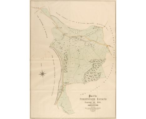
Estate Sale Catalogues. Six estate sale catalogues from Herefordshire, late 19th century & early 20th century, including The Perrystone Estate, Auctioned by Messrs. Debenham, Tweson, Farmer & Bridgewater, 10th August 1886, uncoloured lithographic view of the main house, an additional lithograph of the view from Wood Walk, details of acreage, tenants and rent and a large colour lithographic folding map of the whole estate, decorative publisher's paper wrappers with some dust soiling, slim folio, together with The Harewood Estates, Auctioned by Farebrother, Ellis, Clark & Co., July 1877, two tint stone lithographs of the main house, large colour lithographic folding map of the whole estate, decorative publisher's paper wrappers with some dust soiling, slim folio, with Holme Lacey, Auctioned by Knight Frank & Rutley, 29th July 1909, frontispiece of a double-page Ordnance Survey map of the area surrounding the property, some creasing and two closed tears affecting the printed image, numerous uncoloured gravures of various properties within the estate, details of acreage, tenants and rent, publisher's paper wrappers, stained, dust soiled and frayed, slim folio, with an additional smaller auction catalogue containing a lithographic folding map of the whole estate, 4to and a separate folder containing two large folding maps of the estate, plus Eaton Bishop, Kingstone & Madley, Auctioned by Messrs. Stooke & Son, 7th June 1905, two large folding colour lithographic maps of the estates, details of acreage, tenants and rent, publisher's printed paper wrappers, slim folio, with another untitled folding estate planQty: (7)

Glamorganshire. Speed (John), Glamorgan Shyre with the Sittuations of the Cheife Towne Cardyff and ancient Llandaffe described, John Sudbury & George Humble, circa 1627, hand-coloured engraved map, inset town plans of Cardiff and Llandaff, slight chipping and staining to the margins, the right-hand vertical margin trimmed to the platemark, the left-hand vertical margin trimmed with slight loss to the strapwork margin, replaced in facsimile and extended, 380 x 505 mm, English text on the verso, together with Blaeu (Johannes). Glamorganensis comitatus vulgo Glamorgan Shire, Amsterdam, circa 1650, engraved map with contemporary outline colouring, 385 x 510 mm, French text on verso, with Sanson (Nicolas). Principauté de Galles..., Paris, 1658, engraved map with contemporary outline colouring, some fraying to the margins but not affecting the printed image, toned overall, 375 x 435 mmQty: (3)

Hampshire. Speed (John), Hantshire described and devided, John Sudbury & George Humble, circa 1627, hand-coloured engraved map, inset town plan of Winchester, several repaired closed tears affecting the margins and the printed image, very slight staining, 380 x 510 mm, mounted, framed and glazedQty: (1)

Harrison (John). A collection of 21 foreign maps, 1789, 20 uncoloured engraved double-page maps and 1 single page map, each approximately 390 x 505 mmQty: (21)Footnote: The maps consist of. Orbis Veteribus Notius - Ancient World, Particular Map of the Western Coast of Africa from Cape Blanco to Cape de Verga, Asiae quae vulgo Minor Dictur et Syriae, Arabian Gulf or Red Sea, Aegyptus Antiqua, Coromandel, A Correct Map of the North-West part of Germany, The Euphrates and the Tigris, Egypt, Gallia Antiquae, Graeciae Antiquae, Germanie France Italie Espagne Isles Britanniques, Coast of Guinea, The Coasts of Greece, Ad Antiquam Indiae..., Tabula Italiae Antiquae, Persian Gulf, Orbis Romani pars Orientalis, Orbis Romani pars Occidentalis, Draught of the Bay of Bulls between the Town of Rotta and Fort St. Catherine..., [and] A Plan of the Situation and Remarkable Manuvers of the English and the Combin'd Fleets of France & Spain...,
![Hungary & Transylvania. Ortelius (Abraham), Transilvania [1573], hand-coloured engraved map, library blind stamp to lower](https://cdn.globalauctionplatform.com/0b58d581-ebd7-4ad4-9c12-ae4000b9ea0d/a69b8c09-8259-43e5-ab5c-ae4001049c9c/468x382.jpg)
Hungary & Transylvania. Ortelius (Abraham), Transilvania [1573], hand-coloured engraved map, library blind stamp to lower right corner, but not affecting the printed image, slight mount staining, 310 x 435 mm, Dutch text on verso, together with another later example, circa 1610, no text on verso, with Ungariae Loca Praecipua Recens Emendata atque Edita, per Ioannem Sambucum Pannonium, Imp. Ms. Historicum. 1579 [1592 or later], uncoloured engraved map, library blind stamp to lower right corner, but not affecting the printed image, some staining and dust soiling, 345 x 500 mm, no text on verso, plus Van den Keere (Pieter). Hungaria [1627 or later], hand-coloured engraved miniature map toned overall, 85 x 125 mm, English text on verso, with another uncoloured example, with two other maps similar, various sizes and conditionQty: (7)Footnote: The first three described maps, Marcel Van den Borecke, Ortelius Atlas Maps, nos. 152, 153 and 151.1.

Hungary. Speed (John), The Mape of Hungari newly augmented..., George Humble, 1627, hand-coloured engraved carte-a-figures map, eight costumed figures to the vertical margins and four oval vignettes of principal cities along the upper margin, very slight worming, 395 x 520 mm, English text on versoQty: (1)

Ireland. Speed (John), The Province of Connaugh with the Citie of Galwaye Described, John Sudbury & George Humble, circa 1627, hand-coloured engraved map, inset town plan of Galway, large strapwork cartouche and mileage scale, central fold split and crudely repaired on verso, some staining and mould bloom, 390 x 515 mm, English text on verso, framed and double-glazed, together with Allen (William H.). An Improved Map of India Compiled from the latest documents, is respectfully dedicated to Major James Rennell F. R. S. &c. &c. &c. London Corrected 1842, engraved map with contemporary hand-colouring, sectionalised and laid on linen, very slight staining, 940 x 815 mm, later presentation inscription to rear of front board, publisher's cloth gilt boards, boards faded and stained, with Wyld (James). Map of Europe Exhibiting its Principal States and Physical Features..., circa 1870, engraved map with contemporary outline colouring, sectionalised and laid on linen, 535 x 685 mm, contained in a contemporary cloth slipcase with printed label to upper cover, plus Dower (John). The Chronological and Geographical Family Guide to the Bible, circa 1850, large engraved map of the Mediterranean, sectionalised and laid on linen, inset maps of Canaan and Palestine, 1180 x 1480 mm, with another five British and foreign maps, including examples by Brué, Norden/Kip, Stanford and Cruchley, various sizes and condition Qty: (10)
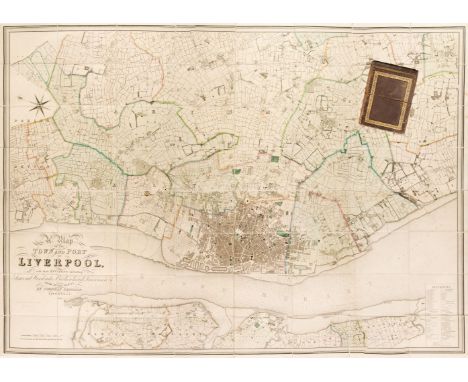
Liverpool. Bennison (Jonathan), A Map of the Town and Port of Liverpool with the Environs including Seacomb, Woodside, Birkenhead, Tranmere &c. from actual survey, Liverpool, Sept. 1835, large map, engraved by John Dower, with contemporary outline colouring, sectionalised and laid on linen, calligraphic cartouche, compass rose and table of reference, slight offsetting, 1280 x 1780 mm, marbled endpapers, contained in a contemporary morocco gilt book box, book box worn and rubbedQty: (1)Footnote: A fine example of this impressive large scale map of the city of Liverpool.

London. Andrews (J.), Andrews's New and Accurate Map of the Country Thirty Miles round London, on which are Delineated from an Actual Survey His Majesty's Palaces, Noblemen and Gentlemen's Seats, Market Towns, Villages, Churches, Rivers, Parks, Heaths & Remarkable Hills, all the Turnpike & most of the Cross Roads with the Distances from Town to Town according to the Mile Stones, 1782 - 96, engraved map with contemporary outline colouring, sectionalised and laid on linen, some dust soiling and slight wear where old folds cross, occasional short splits along the linen, 875 x 630 mm, contained within a contemporary marbled slipcase with printed title label to the upper cover, slipcase worn and rubbedQty: (1)Footnote: James Howgego. Printed Maps of London, 1553 - 1850, no. 172, a variant state (not listed in Howgego) between 1 & 2 with the date unaltered but John Andrews's address changed but retaining Mr Harris's old address.

London. Weller (Edward), Civitas Londinum Ano Dni Circiter MDLX. London in the Reign of Queen Elizabeth, a facsimile (reduced) of the map by Aggas 1566, published Weekly Dispatch, circa 1865, uncoloured engraved panoramic map of London on two conjoined sheets, slight staining, small area of loss to the central join, overall size 460 x 1235 mm, mounted, framed and glazedQty: (1)

London. Wyld (James), Environs of London, 1847, engraved circular map with contemporary outline colouring, sectionalised and laid on linen, edged with green silk, overall size 655 x 590 mm, marbled endpapersQty: (1)Footnote: James Howgego. Printed Maps of London 1553 - 1850, no. 344 state 4.

Madeira. Johnston (William), Geo Hydrographic Survey of the Isle of Madeira with the Dezertas and Porto Santo Islands Geometrically taken in the Year 1788, W. Faden Jany. 1st. 1791, hand-coloured engraved map, inset plan of Funchal and two horizon profiles, numerous rhumb lines, slight dust soiling, occasional repaired marginal closed tears, 605 x 770 mmQty: (1)

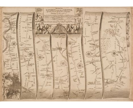
Ogilby (John). The Road from London to the City of Bristol, circa 1676, uncoloured engraved strip road map, slight browning to the margins, 340 x 470 mm, together with The Road from London to Carlisle in com. Cumberland, circa 1676, uncoloured engraved strip road map, slight spotting and browning, 340 x 420 mmQty: (2)Footnote: Map numbers 10 & 37.

Oxford. Pearson (R. publisher), New Map of the University and City of Oxford, 1817, largely uncoloured engraved map, originally published for Pearson's 'Walks in Oxford', sparse outline colouring to the margin, key plates identifying 44 places of interest, old folds, slight dust soiling, 390 x 465 mm, framed and glazedQty: (1)

Oxfordshire. Speed (John), Oxfordshire described with ye Citie and the Armes of the Colledges of that famous University, Roger Rea [1650 - 62], hand-coloured engraved map, inset town plan of Oxford, the vertical margins decorated with 18 heraldic shields, slight overall toning, 375 x 510 mm, mounted, framed and glazedQty: (1)
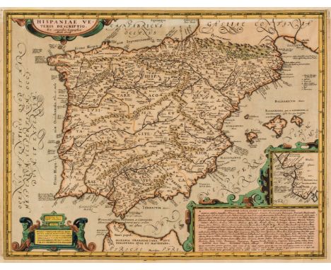
Spain & Gibraltar. Ortelius (Abraham), Hispaniae Veteris Descriptio, circa 1600, hand-coloured engraved map, strapwork cartouche and 17 lines of people, places, mountains and rivers, toned overall, inset map of the environs of Cadiz and Gibraltar, some marginal staining, 375 x 485 mm, no text on verso, together with Sayer (Robert & Bennett John, publishers). A Plan of the Town and Fortifications of Gibraltar with the Spanish Lines and Attacks, 28th October 1782, hand-coloured engraved plan with inset maps of The Bay of Gibraltar and the Straits of Gibraltar, some dust soiling, some dust soiling, 370 x 550 mmQty: (2)Footnote: The first described item. Marcel Van Den Broecke, Ortelius Atlas Maps, no 193.
![Surrey. Speed (John), Surrey Described and Divided into Hundreds, Thomas Bassett & Richard Chiswell [1676], hand-coloured](https://cdn.globalauctionplatform.com/0b58d581-ebd7-4ad4-9c12-ae4000b9ea0d/a98ab2ab-94d0-4cc6-8657-ae400104a994/468x382.jpg)
Surrey. Speed (John), Surrey Described and Divided into Hundreds, Thomas Bassett & Richard Chiswell [1676], hand-coloured engraved map, inset views of Richmond and Nonsuch palaces, some restoration to the central fold, upper margin trimmed to the neatline, skillfully replaced and extended with a small area in facsimile, 385 x 515 mm, mounted, framed and glazedQty: (1)

![Wales. Ortelius (Abraham & Lhuyd Humphrey), Cambriae Typus Auctore Humfredo Lhuydo Denbigiense Cambrobritano [1573], unco](https://cdn.globalauctionplatform.com/0b58d581-ebd7-4ad4-9c12-ae4000b9ea0d/2a2b168f-88f9-42a0-b320-ae400104ac20/468x382.jpg)
Wales. Ortelius (Abraham & Lhuyd Humphrey), Cambriae Typus Auctore Humfredo Lhuydo Denbigiense Cambrobritano [1573], uncoloured engraved map, large strapwork cartouche and mileage scale, very slight staining to the margins, 370 x 495 mm, German text on versoQty: (1)Footnote: Marcel van den Broecke. Ortelius Atlas Maps. no.21 first state. John Booth. Antique Maps of Wales. no. 1.
![Wales. Speed (John), Wales, Thomas Bassett & Richard Chiswell [1676], hand-coloured engraved map, twelve oval vignettes o](https://cdn.globalauctionplatform.com/0b58d581-ebd7-4ad4-9c12-ae4000b9ea0d/2a698fa6-a7a9-4456-8168-ae400104ace0/468x382.jpg)
Wales. Speed (John), Wales, Thomas Bassett & Richard Chiswell [1676], hand-coloured engraved map, twelve oval vignettes of principal cities to the vertical margins and inset views of Bangor, St. Davids, Llandaff and St Asaph, one short repaired closed tear at the base of the central fold, 385 x 510 mm, English text on versoQty: (1)Footnote: John Booth. Antique Maps of Wales, no. 8.
World. Senex (John), A Map of the World corrected from the observations communicated to the Royal Societys of London and Paris, 1725, large engraved map with contemporary outline colouring, four female figures at the head of the centrefold (representing the four continents), extensive printed historical details, old folds, slight creasing, occasional repaired closed tears, torn with small areas of loss to the corners, skillfully replaced in facsimile, appears to be laid on to card, 590 x 1080 mm, mounted, framed and glazedQty: (1)Footnote: First published in 1711 this later corrected edition now shows California as a peninsula and not as an island. The borders are crammed with information on the tides, winds and monsoons and water evaporation.

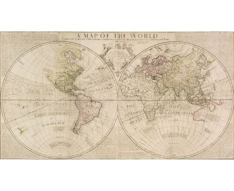
World. Speed (John), A new and Accurat Map of the World Drawne according to ye truest Descriptions latest Discoveries & best Observations yt have beene made by English or Stangers, Thomas Bassett & Richard Chiswell [1676], hand-coloured engraved map of the world on a hemispheral projection, two further circular astrological projections, the map surrounded by portraits of explorers, allegorical depictions of the four elements and celestial diagrams, central fold strengthened and repaired on verso, left-hand vertical margin extended, lower margin trimmed with slight loss to printed strapwork border, replaced in facsimile and margins replaced, 395 x 520 mm, English text on verso,Qty: (1)Footnote: R. W. Shirley. The Mapping of the World, no. 317.
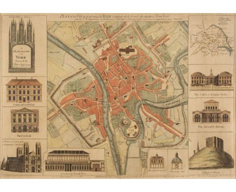
York. Chassereau (Peter), Plan de la Ville et Foubourgs de York, Capitale de la comté du meme nom..., avec les Augmentations, M. A. Rocque, London & W. Tesseyman, York, 1766, hand-coloured engraved city plan, title repeated in English in the upper left corner within an ecclesiastical cartouche, the plan surrounded by nine vignettes of notable buildings and a small county map of Yorkshire showing the Roman roads, 450 x 645 mmQty: (1)Footnote: A scarce separately published map of York; first published in 1750 and then re-issued in 1766.

Martin (R. Montgomery). The Illustrated Atlas and Modern History of the World..., J & F Tallis, London & New York, circa 1855, decorative calligraphic title, frontispiece of a map of the world, descriptive text and 79 engraved maps by J. Rapkin with contemporary outline colouring, two comparison plates and an uncoloured double-page pictorial map of Liverpool, slight marginal staining and dust soiling throughout, occasional short marginal closed tears, some water staining to the endpapers, near-contemporary half morocco gilt over later boards, folioQty: (1)
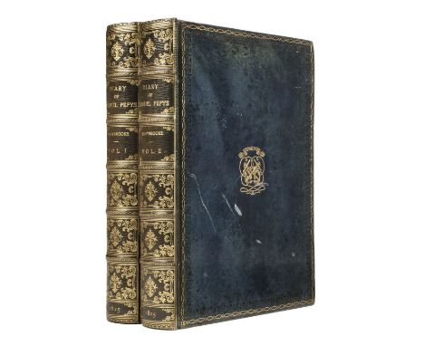
Braybrooke (Richard). Diary of Samuel Pepys, London: Henry Colburn, 1825, half-titles, frontispieces, 10 engraved plates, folding map, turn-ins finished in gilt, marbled endpapers and pastedowns, bookplates to front pastedowns, hinges repaired, lightly spotted, 19th-century blue morocco gilt, spine in 6 compartments separated by raised bands finished in gilt, 4 compartments incorporating gilt floral tools, 2 with gilt directs, compartments bordered in gilt, boards with oval gilt border, gilt armorial vignettes to centre of boards, extremities slightly rubbed, boards marked, folioQty: (2)
-
109182 item(s)/page