We found 109198 price guide item(s) matching your search
There are 109198 lots that match your search criteria. Subscribe now to get instant access to the full price guide service.
Click here to subscribe- List
- Grid
-
109198 item(s)/page


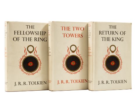
Lot 136
Tolkien (J.R.R.) The Lord of the Rings, 3 vol., first editions, first impressions, The Return of the King with signature mark '4' and text block sagging, folding map at end of each vol., ink gift inscription in the year of publication on each front free endpaper, light tape staining on endpapers, The Two Towers endpapers with light toning strip, original cloth, fine, dust-jackets, very light scuffing to corners, jacket spine lightly creased, otherwise a bright, crisp, and near-fine set, [Hammond & Anderson A5], 8vo, 1954-55.
Lot 145
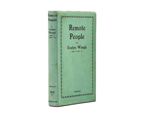
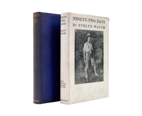
Waugh (Evelyn) Ninety-Two Days, first edition, folding map and illustrations, dust-jacket, light surface soiling, extremities and corners chipped and nicked, 1934; Labels, cloth spine faded, [Davis 10], 1930, first editions, original cloth, 8vo (2) *** First edition of Waugh's third travel book, in the rare jacket. It chronicles a 92-day expedition across Latin America, illustrated with Waugh's own photographs. Grouped together with Waugh's first travel book Labels.
Lot 149
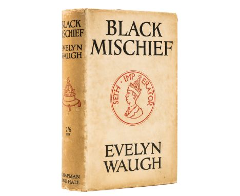
Waugh (Evelyn) Black Mischief, first trade edition, signed by the author on title, map frontispiece, pencil ownership inscription to endpaper, original cloth, slight shelf-lean, light toning to spine, 2 short splits to head of spine, light rubbing to extremities, spine browned, spine ends and corners a little chipped, light rubbing to extremities, but an excellent copy overall, 8vo, 1932. *** Black Mischief was published in both trade and limited editions, with the latter used by Waugh in part for presenting as gifts. As a result, the first trade edition is one of the most difficult of Waugh's titles to find signed.
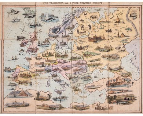
Lot 157
Games.- Spooner (William) The Travellers; or, A Tour Through Europe, hand-coloured lithograph map of Europe including vignettes of cities & people or animals typical of the region, c.505 x 630mm., dissected and mounted on linen, a little soiled and stained, slight fraying to lower edge and to edges & corners of sections, a few splits to folds, folding into original cloth folder with lithographed pictorial label to upper cover, rather worn and stained, [Whitehouse p.18], 1842 § New Royal Game of Goose (The), hand-coloured lithographed sheet depicting a goose containing 63 numbered circles, some containing illustrations including a railway station, a train and the Crystal Palace, with rules in box above and border with ornamental corners, c.435 x 545mm., lightly browned, folding into original board folder with hand-coloured illustration to upper cover, rubbed, [Whitehouse p.69], n.p., [c.1855] § Jeu du Nain Jaune/Jeu de Bog, 2-sided game, 6 folding conjoined triangular shapes which when unfolded form a hexagon with a circle cut out of the middle, c.375 x 430mm., lithographed sheets mounted on both sides of board forming 2 games, each with title and 5 hand-coloured playing cards including Knave, Queen & King (Nain Jaune with Lancelot, Palais & Charles, Bog with Lancelot, Rachel & David), 2 sheets of Nain Jaune a little rubbed and soiled, Paris, [c.1860] § Hammer- und Glockenspiel, 5 hand-coloured engraved sheets mounted on thick card (Hamer, Glogge, Kaufthaus, Hamer und Glogge, Schimel), each c.130 x 90mm., rather soiled, one creased from folding, together with letterpress sheet of rules (creased and wormed with loss of a few letters) in original marbled board slip-case, rubbed, [Austria/Germany], [c.1825]; and a copy of De La Rue's portable chess & draught board (designed by Owen Jones) with removable 2-sided pieces tucked into slots (1870s), v.s. (5)

Lot 181
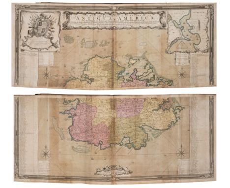
West Indies.- Johnson (Col. John, Lieutenant-Governor of Nevis) An Historical and Descriptive Account of Antigua..., title, errata slip, the large folding map 'A New & Improved Map of the Island of Antigua, in the West Indies. Constructed and drawn chiefly from original Materials and most Recent Surveys. By J. Johnson', 11 pp. of historical accounts of Antigua, lithographed vignette title 'Part the Second' with two lithographed maps, and some text only, without any aquatint plates, spotting and browning throughout, some heavy, the folding map with bright hand-colouring, dissected and mounted on linen, with damp-staining to sheets towards the end and elsewhere, front-free endpaper detached, loose, contemporary calf with upper cover gilt, upper cover detached and loose, lacking spine, boards very worn, oblong folio, printed by Henry Baylis for the author, 1830.
Lot 182
West Indies.- Wilkinson (Robert) Atlas of the West-Indies, composite atlas with manuscript title and contents, 28 engraved maps and charts on 32 sheets, with four maps divided into North and South sheet sections, all with hand-colouring, many folding, various sizes between 490 x 620 mm (19 1/4 x 24 3/8 in) and the largest single map approx. 1640 x 940 mm (64 1/2 x 37 in), all with discolouration and browning to green copper pigment used, some splitting to old folds, numerous handling creases throughout, rather heavy surface dirt, half calf, spine with title 'Atlas of West Indies', elephant folio (595 x 530 mm), [circa 1795-1815]*** Important publisher's composite atlas with numerous large and early maps of the West Indies, including:- Delarochette (Louis) A Map of North America and the West Indies, engraved map in two sections, [1795-1825] - Speer (John Joseph) A General Chart of the West Indies, engraved map, 1796- Lempriere (Charles) [Sea Chart of Bermuda], engraved map, 1738 [but probably later]- Jefferys (Thomas) Three sheets from the 'West India Atlas' [covering the Coast of Yucatan, Island of Cuba, and the Windward Passage], engraved map, [c. 1775 or slightly later]- Browne (Patrick) A New Map of Jamaica, engraved map, 1797- Faden (William) Isle of St. Domingo or Hispaniola, engraved map, 1796- Laurie & Whittle Turks Islands, engraved map, 1794- Richmond (M.) A Map of the Caribbee, Granadilles and Virgin Isles, 1789- Jefferys (Thomas) The Virgin Islands from English and Danish Surveys, 1794- Faden (William) The Island of St Eustatius corruptly St Eustatia, 1795- Baker (Samuel) A New and Exact Map of the Island of St. Christopher in America, 1753- Baker (Robert) A New and Exact Map of the Island of Antigua in America, 1748- Jefferys (Thomas) Guadaloupe Done from Actual Surveys and Observations of the English, 1794- Jeffreys (Thomas) Martinico, 1794- Jefferys (Thomas) St. Lucia, 1794- Mayo (William) A New and Exact Map of the Barbadoes in America- Byres (John) ... His Majesty's Island of Dominica ..., 1794- Byres (John) Plan of the Island of Bequia, 1776 [but 1794]- Paterson (Lieut. Daniel) A New Plan of the Island of Grenada, 1796- Byres (John) Plan of the Island of Tobago, 1794- Delarochette (Louis) The Coast of Guyana, 1783- Anderson (John) Chart of the River and Sea Coast of the Colony of Demerary..., - Jefferys (Thomas) Curacao from the Dutch Originals..., c. 1795- Jefferys (Thomas) Ruatan or Rattan..., 1794- Faden (William) A Map of a Part of Yucatan or of that Part of the Eastern Shore within the Bay of Honduras Alloted to Great Britain for the Cutting of Logwood, 1787- Kitchin (Thomas) South America with Its Several Divisions, 1794
Lot 207
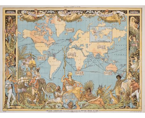
World.- Crane (Walter) Imperial Federation, Map of the World showing the extent of the British Empire in 1886, printed to coincide with the Colonial and Indian Exhibition of 1886, lithographic map printed in colours, sheet 615 x 820 mm (24 1/4 x 32 1/4 in), old folds, some expert repairs to tears, mainly visible verso, otherwise minor toning, unframed, published as a supplement to The Graphic, London, Maclure & Co., 24 July 1886.
Lot 208
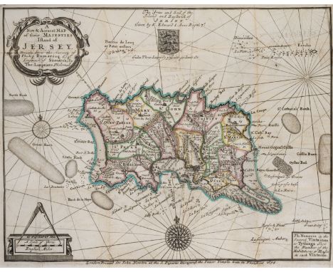
Channel Islands.- Falle (Philip) An Account of the Isle of Jersey, first edition, half-title, previous owner's ink inscriptions to half-titles, engraved diagrams, engraved folding map hand-coloured in outline, 2 short tears at gutter with old tape repairs verso, short marginal tear with small loss to foot K1, publisher's advertisements at end, modern antique style panelled calf, gilt, for John Newton, 1694; Histoire détaillée des Isles de Jersey et Guernesey, first French edition, 2 folding engraved maps, short tears at gutter with old tape repairs verso, engraved diagrams, previous owner's inscription to front pastedown and front free endpaper verso, occasional faint spotting, later calf-backed boards, slight rubbing to corners, Paris, 1757; 8vo & 12mo (2) *** Provenance: Both inscribed to or by Rear Admiral John Saumarez Dumaresq (1873-1922). The Dumaresq family was a patrician family in the Channel Islands, with a particular interest in Jersey. Each volume contains a map drawn from a survey by Philip Dumaresq. On the accession of King James II, Philip Dumaresq presented him with an account of the Channel Islands and suggestions for their defence.

Lot 209
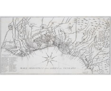
London.- Cary (John) Cary's New and Accurate Plan of London and Westminster, the Borough of Southwark and parts adjacent..., large detailed map with an alphabetical list of upwards of 500 of the most principal streets with references to their location on the map, hand-coloured engraved map, 820 x 1525mm., dissected and mounted on linen, lightly browned, small stain to top left corner at edge, split to one fold, folding into marbled board slip-case with printed label to upper cover, rubbed and worn, tall 8vo, 1815. *** Showing London at the end of the Regency period of George IV. The map had to be extended in 1811 to accommodate the development of Docks on the Isle of Dogs and here in 1813 to show Regent’s Park and the Regent’s Canal moving eastwards.
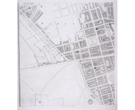
Lot 211
London.- Horwood (Richard) Plan of the Cities of London and Westminster the Borough of Southwark and Parts adjoining Shewing every House, large bound wall map of London, composite collection from the first and second editions, 23 sheets only (of 32, lacking sheets A4, B2-B3, C2, D2, E3-E4, F3-F4, G3-G4, H3-H4), presented on a scale of twenty-five inches to the mile, extending from Angel to Limehouse, and Kennington to Brompton, engravings on various cream wove papers, some with watermarks 'Horwood's Map of London', each individual sheets approx. 560 x 650 mm (22 x 25 1/2 in), or smaller with some sheets trimmed, some on stubs, some loose, scattered surface dirt, occasional nicks to extremities, later half calf, covers detached, lacking spine, manuscript inscription to upper cover, very worn, elephant folio, [cf. Howgego 200], [c.1792-1807]*** The largest map printed in Georgian Britain, and a defining study of London at the end of the eighteenth century. Horwood's plan was the first map of London to attempt to show every individual property, and took over 7 years to complete following numerous logistical and financial obstacles.
Lot 217
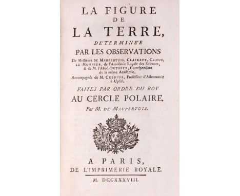
Astronomy.- Maupertuis (Pierre-Louis Moreau de) La Figure de la Terre..., first edition, 1 engraved map and 9 plates, all folding, printer's device to title, contemporary mottled calf, small tears to lower cover edge, and a little rubbed elsewhere, 8vo, Paris, l'Imprimerie Royale, 1738.*** First edition of this famous work on the applanation of the earth at the poles; Maupertius headed the scientific expedition to Lapland, with the objective to confirm Newton's theory of the flattening of the earth at the poles, with the results proving fatal to the Cassinian hypothesis.
Lot 229
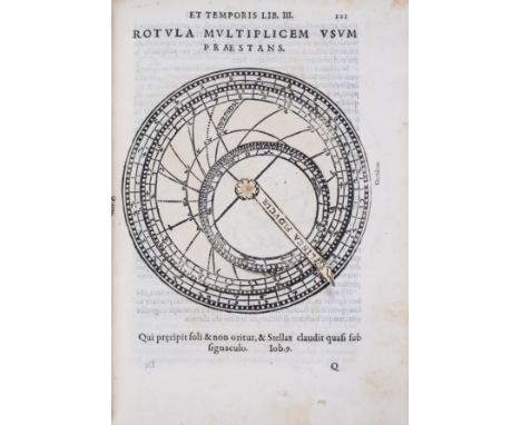
Celestial atlas.- Gallucci (Giovanni Paolo) Theatrum mundi, et temporis, first edition, first issue, title with woodcut printer's device, 144 astronomical illustrations, of which 31 (of 51) with volvelles (some skilfully restored with facsimile elements; some possibly from other copies), additional f. after Mm4 showing the constellation Cepheus, folding letterpress table and errata f. at end, woodcut head and tail-pieces and decorative initials, occasional extensive 18th century Italian manuscript notes, including to verso of title, partially erased small ink stamp to title, sig. Ooo at end misbound, some foxing and staining, lightly browned, later endpapers, recased in contemporary limp vellum, splits to joints, but holding firm, a few small repairs, some staining, [Adams G168; Houzeau & Lancaster 2725; Mortimer Italian 206; Riccardi I, 568; Tomash & Williams G24; Warner 91; EDIT 16 CNCE 20287], 4to, Venice, Giovanni Battista Somasco, 1588. *** The first celestial atlas to use Copernican co-ordinates. 'There are 48 woodcut maps of the Ptolemaic constellations, each of which is preceded by a catalogue of the included stars identifying position within the constellation, latitude and longitude (in degrees and minutes), magnitude, and nature ... The longitudes on Gallucci's catalog and on his map are those published by Copernicus in De Revolutionibus (1543)' (Warner). Gallucci (1538- c.1621) was a private tutor to the Venetian nobility and founding member of the Second Venetian Academy.
![Middle East.- Doughty (Charles M.) Travels in Arabia Deserta, 2 vol., first edition, [one of 500 copies], 8 plates, some fold](https://cdn.globalauctionplatform.com/88bbc871-be35-4bee-8f50-b0ec0107b8ce/7f605e4b-045c-444d-8c1f-b0ee011f80e9/468x382.jpg)
Lot 25
Middle East.- Doughty (Charles M.) Travels in Arabia Deserta, 2 vol., first edition, [one of 500 copies], 8 plates, some folding, numerous illustrations, folding colour map in pocket at end of vol.1, 32pp. publisher's catalogue, lacking half-titles, 20th century half morocco, very light fading to spine, corners a little bumped, t.e.g., 8vo, Cambridge, 1888.*** Classic work on the exploration of Arabia which contains so much information on the topography of the area that it was used as a text-book by the British army during the Arab Revolt. There are also detailed descriptions of the Bedouin tribes and their customs.

Lot 28
Scotland.- Thomson (John) The Atlas of Scotland, containing Maps of Each County, 2 hand-coloured engraved double-page panoramas (Principle Mountains & Principle Rivers), 58 double-page hand-coloured engraved maps, engraved index map, all hand-coloured in outline, a few neat marginal repairs, some very light offsetting, light foxing to text ff., later crushed green half morocco, rubbing to extremities, [Chubb, Scotland XXXII], large folio, Edinburgh, 1832

Lot 30
Stirling (Major William) The Rivers of Paradise and Children of Shem... and a Disquisition Concerning the Expedition of Sesostris Into India, 2 lithographed plates, 2 A.L.s. from the author and an offprint article by the author on the Seychelles signed and annotated by the author all loosely inserted, 1855 § Stein (Sir Marc Aurel) Ruins of the Desert Cathay, 2 vol., frontispieces, 6 folding panoramas, 3 folding maps, plates, some colour, spotting, some splitting to gutters, spotting to spines and covers, 1912 § Lear (Edward) Journals of a Landscape Painter in Albania, map and 20 tinted lithographed plates, green endpapers, [Abbey, Travel 45], 1851, first editions, original cloth, light toning to spines, light soiling, some rubbing and bumping to extremities, 1851; and another, travel, 8vo (5)
Lot 35
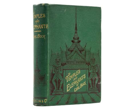
Thailand.- Bock (Carl) Temples and Elephants, first edition, portrait frontispiece, folding map, plates and illustrations, 2pp. advertisements, original pictorial cloth, slight bumping to spine tips and corners, light rubbing to extremities, an excellent copy, 8vo, Sampson Low, 1884. *** Rare in the original cloth. With the support of King Chulalongkorn, Bock undertook his exploration of the interior of Siam and Laos in 1881.
Lot 75
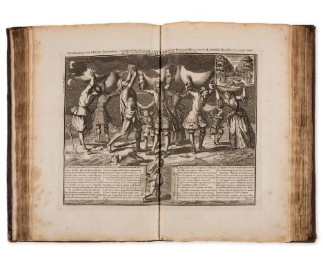
South Sea Bubble.- Het Groote Tafereel der Dwaasheid, Vertoonende de opkomst, voortgang en ondergang der Actie, Bubbel en Windnegotie ..., first edition, title in red and black, 71 engraved plates and maps (including map of Louisiana), of which 55 folding, 3 with tears and neat repairs verso, 5 with splits to foldlines, 5 with short tears, occasional marginal spotting, 2 ff. with tiny rust-holes affecting odd letter, pencil signature to early blank, bookplates, contemporary calf, gilt lozenge to centre of boards, gilt borders with crowns at inner corners, rubbed and mottled, neat old repairs to spine extremities, bumping to corners, [Goldsmith 5879; Kress 3217], folio, [Amsterdam], 1720 *** Bookplates of R. Kirk, Greenmont and Otto Orren Fisher. First edition of "The Great Mirror of Folly", made up of "various pieces in prose and verse which together with the prints, pertain to the speculative period in Holland coincident with the 'Mississippi bubble' in France." (Kress)
Lot 77
Venetian waterways.- Rompiasio (Giulio) Metodo in Pratica e Sommario o sia Compilazione delle Leggi..., second edition, half-title, title in red & black with engraved vignette, woodcut tail-pieces and initials, folding engraved map, light water-staining to upper edge of last few leaves and map at end, contemporary limp marbled boards, uncut and unopened, light damp-staining, lacking some of marbled paper covering from upper cover and title, 4to, Venice, Stamperia Ducale, 1771.*** Scarce work on the laws relating to Venetian watercourses, first published in 1733, concerning the administration, the preservation of the lagoon and the canals of Venice, the various gates, fishing rights, and regulations for building on the shores, before moving to inland rivers, describing the laws surrounding bridges and fords, and the tariffs imposed on river traffic.
Lot 90
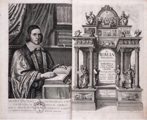
Bible, Polyglot.- Biblia Sacra Polyglotta, 6 vol., first edition, edited by Brian Walton, vol.1 with engraved portrait frontispiece of Walton by P. Lombart, additional engraved title, double-page engraved map of the Holy Land ruled in red, double-page engraved plan of Jerusalem, 4 plates (3 double-page),printed cancel slip to omit "vel summorum Pontificum" mounted to p.48, lacking blank leaf at end of vol.1 and 6, some foxing and soiling, 18th century calf, worn, vol.1 rebacked, Thomas Roycroft, 1657; Castell (Edmund) Lexicon Heptaglotton, 2 vol., title in red and black, engraved portrait frontispiece by William Faithorne, some foxing and browning, a few repaired tears, vol.1 18th century calf, rebacked, vol.2 modern calf-backed cloth, Thomas Roycroft, 1669, together 8 vol., folio*** A complete set of this typographic tour de force. This was the fourth great large-scale Polyglot with Ethiopic, Persian, Arabic, Chaldaean, Greek, Hebrew, Latin, Samaritan, and Syriac fonts.Provenance: Bequeathed to the Bishopric of Cornwall by the Rev. Franke Parker, Rector of Luffincott, Devon, 1888 (bookplate).Literature: Darlow and Moule 1446; Wing B2797.


Lot 720
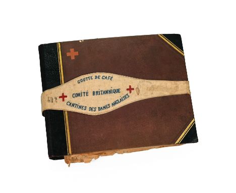
An interesting WWI scrapbook relating to Madeline Baxter of The British Committee Of The French Red Cross, who was based in Vitry-le-Francois. To include a Foreigner’s notebook, identity residence permit dated February 1918, a collection of French postcards, various newspaper cuttings, several photographs of an air raid damage on the 23.3.18, various pencil drawings, various photographs of British Red Cross nurses, postcards, pencil drawing of soldiers and nurses, Cessation of fighting on 11.11.11 note, American Air Force photographs possibly of Edward Willoughby Middleton, Senegalese troops photographs, African American troops, aerial map of Vitry-le-Francois, large collection of unpublished photographs. Contained in an album with attached fabric armband "Goutte de cafe, Comite Britannique, Cantines des Dames Anglaises" ("A drop of coffee, British Committee, English Women's Canteens". Over 20 Pages.Extra information: Scrapbook of Madeline Riva Baxter: born 21 July 1890 in Rainhill, Lancashire, died 6 March 1975 in Stretton, Shropshire.The scrapbook primarily covers the years 1918 to 1919 while Madeline was volunteering with the British Committee of the French Red Cross at an ‘English Ladies Canteen’ in Vitry-le-François. Red Cross canteens are a poorly understood function of the First World War’s female-dominated civilian voluntary services. Madeline had been a member of a Voluntary Aid Detachment before she sailed for France, like famous VAD members, Agatha Christie and Vera Britten, meaning she likely had some volunteer nursing experience. Madeline joined the canteen in Vitry-le-François shortly before it opened on 26 March 1918. Her scrapbook charts her journey via Le Havre, her work in the canteen and her social life among her fellow volunteers and the French, British and American soldiers moving through the region. The Vitry Red Cross canteen was documented by painter Isabel Codrington and official war artist Olive Edis, who was commissioned by the Imperial War Museum to photograph women’s activities on the Western Front. Towards the back, Madeline has pasted in original photographs a female Red Cross member receiving the Croix de Guerre, possibly Aethelflaed Benson. Vitry-le-François is located in the Marne department of France, South-East of Reims. Madeline saw the destruction wrought on Vitry which was at the centre of fighting during the First Battle of the Marne. She would have been in close proximity to the frontline on the last major German offensive on the Western Front: The Second Battle of the Marne in July 1918. 5’9 tall Madeline may feature in a 1919 dated IWM photo by Olive Edis as the central female figure (ref: Q 8066).

Lot 194
Robert De Vaugondy (1688-1766) "Carte De L'Asie" hand coloured map of Asia and the Sea of Korean, housed within a wooden and glazed frame 74cm by 70cm including frame, "dressee sur les relations les plus nouvelles principalement fur les cartes de russie, de la chine, et divise en ses empires et royaumes par le St Robert De Vaugondy fils de Mr Robert Geogr ordin du royAvec Privallige 1750". *CR some discolouration general wear.


Lot 450
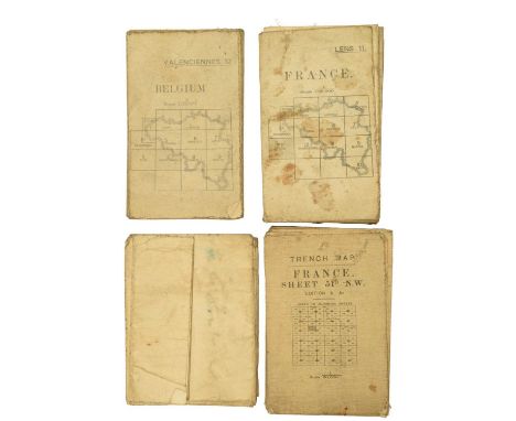
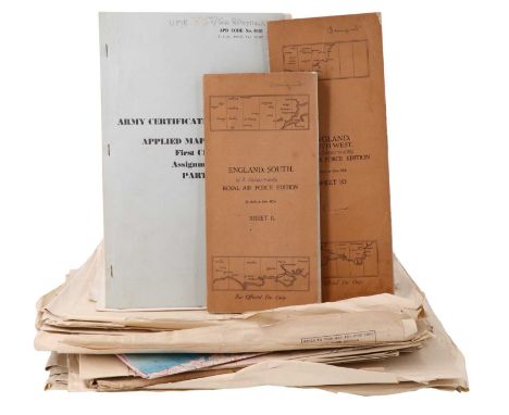
A quantity of Mid 20th Century military aircraft charts relating to Asia, India, Indonesia, etc, dated 1920s - 1944, together with two linen concertina maps 'Royal Air Force Edition', sheets 10 and 11 South and South East England, and an Army Certificate of Education, Applied Map Reading Part 1, 1963
![[ Classic car ] An early 20th Century "Wallis Motor Maps" scrolling automotive map of England, in an ebonized wooden case and](https://cdn.globalauctionplatform.com/ff84713f-54a5-40b4-8023-b0fa00d796e7/ac05db60-a894-4a9b-9eb6-b10101598dc5/468x382.jpg)


Lot 376
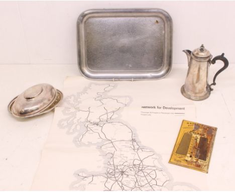
Railwayana: A collection of assorted railwayana related items to include: a William Hutton, early 20th century, 'Great Western Railway Hotels' stamped vegetable dish and cover; a British Railways Network for Development map; LNER planished tray; Perpignan thermometer; and a West & Sons silver plated coffee pot. Items generally in good order, some slight creasing to ma[, damage to thermometer. Please assess photographs. (5)

Lot 367
Hiroshi Yoshida (Japanese, 1876-1950). Japanese shin-hanga woodblock print titled "Three Little Islands" depicting boats on a twilight sea with three small, rocky islands in the distance, 1930. Pencil signed along the lower right; titled along the lower left.One of the leading figures in the Japanese Shin-hanga movement, Hiroshi Yoshida was born in Fukuoka in 1876. In 1893, he moved to Kyoto and studied yoga and nihonga styles of painting and watercolors. It came only in middle age he started collaborating with the shin-hanga publisher Watanabe Shozaburo. Despite his late debut as a shin-hanga printmaker, he successfully put himself on the map as the greatest artist of the shin-hanga style and is especially noted for his excellent landscape prints. His prints are highly recognized in both Japan and overseas.Height: 10 3/4 in x width: 15 3/4 in.Condition:No visible tears or losses. There a few small creases in the upper right quadrant. There are two minute losses along the top margin. Along the lower left quadrant there is some ink residue down the left margin. There is a small, dark spot along the top margin in the upper left quadrant, possibly ink transfer. There are no signs of restoration under UV light. Not framed.

Lot 368
Hiroshi Yoshida (Japanese, 1876-1950). Japanese shin-hanga woodblock print titled "Country Festival" depicting a Kawano country festival in the Kansai region, 1933. Pencil signed along the lower right; titled along the lower left.One of the leading figures in the Japanese Shin-hanga movement, Hiroshi Yoshida was born in Fukuoka in 1876. In 1893, he moved to Kyoto and studied yoga and nihonga styles of painting and watercolors. It came only in middle age he started collaborating with the shin-hanga publisher Watanabe Shozaburo. Despite his late debut as a shin-hanga printmaker, he successfully put himself on the map as the greatest artist of the shin-hanga style and is especially noted for his excellent landscape prints. His prints are highly recognized in both Japan and overseas.Height: 15 1/2 in x width: 10 1/2 in.Condition:There are no losses, creases, or tears. There is light toning along the edge of the top margin. There are a few minute spots of discoloration, down the right and left margins, possibly ink residue. There are no signs of restoration under UV light. Not framed.

Lot 369
Hiroshi Yoshida (Japanese, 1876-1950). Japanese shin-hanga woodblock print titled "A Little Restaurant" depicting a woman standing outside a lit restaurant at night, 1933. Pencil signed along the lower right; titled along the lower left.One of the leading figures in the Japanese Shin-hanga movement, Hiroshi Yoshida was born in Fukuoka in 1876. In 1893, he moved to Kyoto and studied yoga and nihonga styles of painting and watercolors. It came only in middle age he started collaborating with the shin-hanga publisher Watanabe Shozaburo. Despite his late debut as a shin-hanga printmaker, he successfully put himself on the map as the greatest artist of the shin-hanga style and is especially noted for his excellent landscape prints. His prints are highly recognized in both Japan and overseas.Height: 15 1/2 in x width: 10 1/2 in.Condition:There are no visible tears, creases, or losses. The sheet is toned. There are several dark spots along the right margin, possibly ink transfer. There are no signs of restoration under UV light. Not framed.
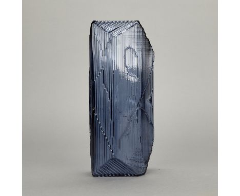
Lot 523
Santtu Mustonen for Iittala, Finland. Glass "Kartta" sculpture in the color "rain" (dark blue) inspired by an imagery map. Etched marks as well as original factory stickers affixed to the underside. With the original box.Height: 12 3/4 in x width: 5 1/2 in x depth: 4 in.Condition:There are no chips, cracks, losses, or signs of wear. Light wear to the box; the inner packaging/padding is not present.


Lot 1054
Cayman Islands, Pirates Week, 1980, brass, milled edge, 32mm (Lyall 145); Cayman National Bank and Trust Co. Ltd, 1981, turtle as a pirate on crossed bones, rev. sailing ship and one doubloon; 1982, rev. map of island; 1983, head of pirate, rev. two palm trees; 1987, head of pirate over crossed cutlasses, rev. map of island, all gold-anodised aluminium, 38mm (Lyall 141-3, –); Cayman Islander Hotel, imitations of 8 Escudo cobs (4), plated alloy, 35-40mm (Lyall 137); similar, imitation of 4 Escudo cob, 25-27mm (Lyall 138); Tiara Hotel, Cayman Brac, imitation of 8 Escudo cob, plated alloy, 35-38mm (Lyall –); Milano Diamond Gallery, advertising token, brass, 27mm; elongated Cent with sailing ship [13]. Very fine or better £40-£60 --- Importation Duty This lot is subject to importation duty of 5% on the hammer price unless exported outside the UK ---


Lot 3079
Pictures and Prints - Views of Derby, an engraving, All Saints Tower at Derby; AJ Keene print, Large's Hospital Friargate Derby; print, Guildhall, Derby; a map of Derby, engraved by Roper, after Cole, c.1810; engravings, Chatsworth, Buxton, Ashborn (sic); a watercolour of Ashbourne; a map of Leicestershire (9)

Lot 414
An Elizabeth II 1945-1995 commemorative dagger by Wilkinson's the blade etched 'To Celebrate Fifty Years of Peace and Reconciliation since the year 1945 when Hostilities between Nations finally halted with the ending of World War II', to one side and 'Peace commands a high price - freedom has never been free. To all those who fought, worked and suffered: paid with their lives to bring peace to the world 50 years ago- and to all those who defend our peace today, this blade is gratefully dedicated.' The hilt in the form of a winged dove with branch, the pommel in the form of a map of the world. Housed in fitted case of issue. L - Dagger 40cm, Box 45cm.

Lot 423
An Elizabeth II 1945-1995 commemorative sword by Wilkinson's Swords, the blade etched ' To Celebrate 50 Years of Peace and Reconciliation Since the Year 1945 when Hostilities Between Nations Finally Halted with the End of WWII' to one side and 'Peace commands a high price-freedom has never been free. To all those who fought, worked and suffered: paid with their lives to bring peace to the world 50 years ago- and to all those who defend our peace today, this sword is gratefully dedicated. The gilt hilt in the form of a winged dove with branch, with wire bound blue leather grip the pommel in the form of a map of the world. 110cm long.

Lot 114
Film Poster (8) - 'Le Bonheur' starring Michael Serrault & Eddy Mitchell, measurements 100cm x 76cm, some folds, 'Honey I Shrunk The Kids' starring Ricky Morganis-measurements 100cm x 76cm, 'Chain Reaction' starring Keanu Reeves & Morgan Freeman, double sided poster. Measurements 100cm x 76cm and 'Legends of the Fall' starring Brad Pitt, Anthony Hopkins & Adrian Quinn. Measurements 100cm x 76cm, 'Oscar' starring Sylvester Stallone, measurements 100cm x 76cm, Facsimile of the Ancient Map of Great Britain (Trimmed) A.D 1325-1350, measurements 62cm x 54cm, 'Fly Away Home' starring Jeff Daniels & Anna Paquin, double sided creased in right hand corner, measurements 100cm x 76cm and '101 Dalmatians' (Dog Print Issue) double sided, measurements 100cm x 76cm, good

Lot 115
Posters - Branding Nations Olympics Poster 2012 - coloured poster-measurements 128cm x 61cm, Advertising Poster (2) - Coleman's Mustard-'Heads The Field'-coloured posters of W.G. Grace-measurement 63cm x 42cm, Showmaster - Robert Nairne from Penny Dreadful, Star Wars, 'The Force Awakens' - Showmasters event coloured poster and Places of Interest and Importance London, coloured map of all interesting places in London, Parks, Cathedrals, Restaurants etc, 1950s approx., 'Dead Beat'-Hunting colour print-drawn by W.J. Shayer Ackermann, London Published March 1st 1864. Framed and glazed, Super Marine Spitfire VBs of no.417 (City of Windsor) Squadron, Royal Canadian Air Force Over North Africa. Good reproduction. 'Austin Powers - International Man of Mystery' starring Mike Myers & Elizabeth Hurley and Walt Disney 'The Fox and the Hound' measures 100cm x 76cm
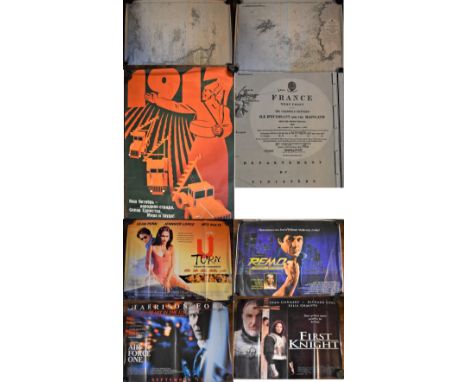
Lot 117
Posters - The Channel Islands - Adjacent Coast of France Survey Map, black and white edition first produced in 1909. Slight tear on edge of map, otherwise good condition. Measurements 100cm x 68cm, France - The West Coast. Measurements 100cm x 68cm and Russian 1917-1987 Agricultural Poster, measurements 96cm x 65cm, 'U Turn' starring Jennifer Lopez & Sean Penn. Measurements 100cm x 76cm, 'Reno' Unarmed and dangerous-starring Joel Grey-measurements 100cm x 76cm, 'Airforce I' starring Harrison Ford. Double sided poster, measurement 200cm x 76cm and 'First Knight' starring Sean Connery & Richard Gere, double sided poster-measurements 100cm x 76cm.
Lot 124
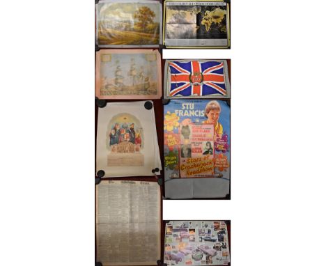
Pictures - Oil on Canvas depicting a rural scene ,measurements 92cm x 62cm-ready for framing, The Golden Age of Discovery 1492-1780-map including Africa, North & South America, Asia. Reprint-crease down middle of Map, Tea Towel 1977 - 'The Queen's Silver Jubilee'. The towel printed as union Jack-measurements 76cm x 45cm and Sovereign of the Sea print, launched at Woolwich in 1637, picture of sailing ship coloured. Measurements 58cm x 44cm poor condition torn and creased, British Motor Cars - Poster-advertising Ford, Jaguar, Rolls Royce etc. Coloured poster measures 84cm x 60cm, Odd Fellows - (3) 'Grand Master-The Board of Directors-(2) Unsigned, (1) Signed Brother Arthur Benjamin Wright 25th Aug 1902-(1) Old Fellows Orphan's Fund-(4) coloured posters-measurements 57cm x 44cm, The Times' - London Friday Dec 7th 1900, advertising 'Money Market Parliament and Star of Crackerjack Roadshow' - entertainment with Sto Francis, Linda Nolan, coloured poster measures 77cm x 50cm
-
109198 item(s)/page