We found 109198 price guide item(s) matching your search
There are 109198 lots that match your search criteria. Subscribe now to get instant access to the full price guide service.
Click here to subscribe- List
- Grid
-
109198 item(s)/page


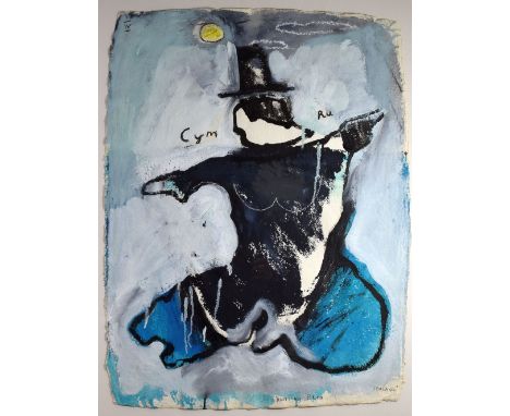
Lot 260
IWAN BALA mixed media on paper - political statement on the Welsh Nation and entitled 'Hon' with an outline map of the Nation and an accompanying letter in Welsh explaining his motivation for the work; Wales was in the 18th and 19th Century depicted as an old woman and that in this version the artist has tried to 'put some life back into her step' and that 'Hon' (her) moves energetically like a dancer. 'Hon' also refers to the poem by T H Parry Williams 'God help me I cannot escape from Her (Wales) and in the same way I cannot escape from trying to change the image of 'Her', signed, 77 x 58cms


Lot 323
ROBERTSON (J), THE ELEMENTS OF NAVIGATION..., and a compendium for finding latitude and longitude at sea, to which is added a treatise for marine fortification, vol II only, 6th edition, folding map frontis, other folding maps and tables, 48pp of transverse tables, worn full calf, London, 1796 (1)
Lot 347
BREECHES BIBLE - EARLY 17TH CENTURY: lacking title to Old Testament, begins with the first book of Moses (repaired), many small engraved details and maps, engraved title to 'the second part of the bible', engraved title to the New Testament, with 'diligent reader' reader page and map verso, last two pages of the second table, full suede calf, London, Robert Barker, 1902 (at fault)
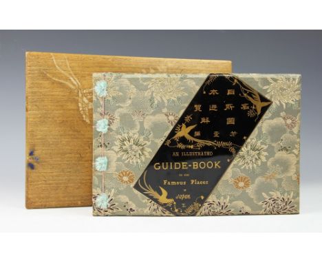
Lot 351
SHIZUKI (TAKAHISA), AN ILLUSTRATED GUIDE BOOK TO THE FAMOUS PLACES OF JAPAN, vol 1, complete with forty-four hand coloured wood block illustrations, comprising 29 full page plates, 8 folding plates, 3 folding plans with key, a folding map, a full page map and frontis piece, gilt pictorial end papers, in original silk work binding with gilt lacquered panel to front board, Tokio, Meikosha, Ginza Sanchome, 1892, in original bamboo two section box decorated with cranes and flowers, Meiji, Japanese, Fuji


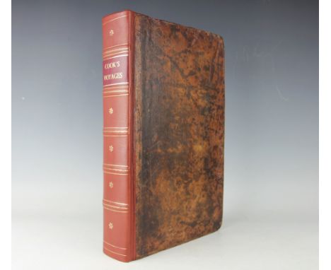
Lot 361
ANDERSON (G), A NEW AUTHENTIC AND COMPLETE COLLECTION OF VOYAGES ROUND THE WORLD...containing an authentic, entertaining, full and complete history of Captain Cook's First, Second, Third and Last Voyages, with 147 engraved plates and maps only (lacking frontis and large folding map)., re-backed full calf, London, Alex Hogg, 1784 (1) (at fault)


Lot 74
Mixed steam related, GER paperweight, Aireys Railway Map of England & Wales, McCorquodale & Co, 50+ GWR parcel labels, 50+ Padstow coach window stickers, rolled poster for framing 'Steam hauled Elizabethan at Kings X 1994', signed by artist Robin Pinnock and owner of 'Union of South Africa' John Cameron, 3 other steam related prints for framing etc


Lot 367
A vintage leather case containing various vintage road maps published by "GW Bacon & Co., 127 Strand London" CONDITION REPORTS The handle of the carry case is missing. The leather is water-marked and split. There have been areas of re-stitching. Scuffed and dis-coloured throughout. There is a screw visible to the back as well as one to the front and another to the base holding the interior together. The Index map's front cover is off. There is also a rip to the centre line as well as in various other places to the same map. It is also foxed and dis-coloured throughout.No. 7 - Map of Lincoln - the cover and back board are both off. Map is torn and worn heavily in various places as well as having severe foxing. Map 9 - The Potteries - there is pencil writing in the right hand border between D and E. No. 10 - Derby and Notts - the back board is separate. No. 21 - Bournemouth - has insect damage to the back board. No. 22 - Brighton - has insect damage to the front board and there is a rip to the edge of the map along the back board - see image. No. 25 - Central Wales - has insect damage to the back board as well as on the map itself. All maps have general wear and tear conducive with age and use to include folds to the corners, discolouration and staining especially along the crease lines. A couple of the maps have more of a greeny colouring - see images for further details.

Lot 366A
A leather case containing a Scottish Road Map published by GW Bacon & Co. Limited, 127 Strand London and a boxed Universal Map Measurer CONDITION REPORTS The case has cracking and crazing all over to the leather and there is a pin hole and nail head showing through to the front and another to the back. Sheet 4 - Oban - has some ballpoint pen markings on it. The Wigtown sheet has an area of discolouration in the sea 4F. All maps have some discolouration and foxing especially the Index Map of Scotland and along the creaselines of all. All have general wear and tear conducive with age and use. See images.


Lot 3170
Nautical Interest, a 19th century diary or log book and voyage chart for Lewis Charlton Shaw on his journey from Gravesend to Sydney, Australia, on board the Clipper Patriarch, April to June 1892, recording a daily account of events on board the ship, captained by Mark Breach, the map annotated, approximately 143 pagesNote: The Aberdeen built White Star ship, the Patriarch made several journeys to Australia between 1870 and 1898


-
109198 item(s)/page