We found 109182 price guide item(s) matching your search
There are 109182 lots that match your search criteria. Subscribe now to get instant access to the full price guide service.
Click here to subscribe- List
- Grid
-
109182 item(s)/page


Lot 439
EDWARD WHYMPER: TRAVELS AMONGST THE GREAT ANDES OF THE EQUATOR, London, John Murray, 1892, 1st edition, half title, 20 plates folding plans, 3 maps including 2 folding as list, the large folding map in pocket at end with repairs, frontis detached, original bevelled olive cloth gilt worn, spine dulled
Lot 442
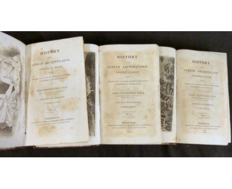
JOHN CRAWFURD: A HISTORY OF THE INDIAN ARCHIPELAGO CONTAINING ACCOUNT OF THE MANNERS, ARTS, LANGUAGES, RELIGIONS, INSTITUTIONS AND COMMERCE OF ITS INHABITANTS, Edinburgh for Archibald Constable, London, Hurst, Robinson, 1820, 1st edition, 3 vols, 34 engraved plates as called for including one coloured, one large coloured folding map, vol 1 lacks half title, contemporary half calf marbled boards, morocco gilt spine labels, re-backed preserving original spines, bookplates of Novar of Raith, Ronald Craufurd Munro Ferguson, 1st Viscount Novar (1860-1934), the sixth Governer General of Australia from 1914-1920, (3)

Lot 444
A & C BLACK COLOUR BOOKS, 10 titles comprising A R HOPE MONCRIEFF: THE PEAK COUNTRY, ill W Biscombe Gardner, 1908, 24 coloured plates as list, one loose, original decorative fawn cloth; DIXON SCOTT: LIVERPOOL, ill J Hamilton Hay, 1907, 25 coloured plates as list, original decorative green cloth; F J SNELL: NORTH DEVON, 1906, 26 coloured plates as list, original decorative blue cloth; CHAS R ROWE: SOUTH DEVON, ill C E Hannaford, 1907, 24 coloured plates as list, original decorative cloth gilt, small part loss of cloth to spine; J M SLOAN: GALLOWAY, ill James Faed, 1908, 25 coloured plates as list, original decorative blue cloth gilt; A R HOPE MONCRIEFF: KEW GARDENS, ill T Mower Martin, 1908, 24 coloured plates as list, one loose, original decorative green cloth; A HEATON COOPER: THE NORWEGIAN FJORDS, 1907, 24 coloured plates as list, original pictorial cloth gilt; W A BAILLIE GROHMAN: TYROL, ill E Harrison Compton, 24 coloured plates as list, original decorative cloth gilt; FRANK FOXX: PEEPS AT MANY LANDS, OCEANIA, 1911, 32 coloured plates and one map as list, original blue cloth, pictorial paper label + one other (10)


Lot 472
COMTE DE LA PEROUSE, one engraved map and two plans, circa 1787 comprising CARTE DE L'ARCHIPEL DES NAVIGATEURS DECOUVERT PAR M DE BOUGAINVILLE EN MAI 1768..., approx 485 x 680mm; PLAN DE LA BAIE DE CASTRIES..., approx 495 x 670mm; PLAN DE LA PARTIES DES ILES OU ARCHIPEL DE COREE..., approx 490 x 675mm + GUILLAUME-NICHOLAS DELAHAYE: [GUINEA], engraved hand coloured map circa 1765, approx 500 x 700mm (4)
![ROBERT MORDEN: SCOTLAND, engraved hand coloured map [1695], approx 435 x 345mm, framed and glazed* vat on buyers premium for](https://cdn.globalauctionplatform.com/cf7defdc-0625-4ced-8134-ad4200e65693/2e7c4532-543b-4e32-a0a1-ad4700f795d6/468x382.jpg)
![RICHARD BLOME: A MAPP OF THE COUNTY OF SUFFOLK..., engraved hand coloured map [1673], approx 260 x 350mm, framed and glazed*](https://cdn.globalauctionplatform.com/cf7defdc-0625-4ced-8134-ad4200e65693/7acea8cb-b23c-4196-8a92-ad4700f797e3/468x382.jpg)

![ROBERT MORDEN: ENGLAND, engraved hand coloured map [1695], approx 355 x 420mm, framed and glazed* vat on buyers premium for t](https://cdn.globalauctionplatform.com/cf7defdc-0625-4ced-8134-ad4200e65693/a0e50ff3-3d8c-43bb-9eb9-ad4700f799ae/468x382.jpg)
![JOHN SPEED: HARTFORD SHIRE DESCRIBED..., engraved hand coloured map [1627], English text verso, approx 380 x 505mm, double gl](https://cdn.globalauctionplatform.com/cf7defdc-0625-4ced-8134-ad4200e65693/5447e53d-7183-4a0e-b8d9-ad4700f79ad7/468x382.jpg)
![RICHARD BLOME: A MAPP OF THE COUNTY OF LEICESTERSHIRE, engraved hand coloured map [1673], approx 245 x 305mm, framed and glaz](https://cdn.globalauctionplatform.com/cf7defdc-0625-4ced-8134-ad4200e65693/8763eaa6-058d-4087-9641-ad4700f79bc4/468x382.jpg)


![ROBERT MORDEN: CORNWALL, engraved hand coloured map, [1695], approx 355 x 420mm, framed and glazed* vat on buyers premium for](https://cdn.globalauctionplatform.com/cf7defdc-0625-4ced-8134-ad4200e65693/68c65cbc-cb81-4562-ace5-ad4700f79f99/468x382.jpg)
![ROBERT MORDEN: SHROPSHIRE, engraved hand coloured map [1695], approx 360 x 420mm, framed and glazed* vat on buyers premium fo](https://cdn.globalauctionplatform.com/cf7defdc-0625-4ced-8134-ad4200e65693/abeba422-27b8-4336-8126-ad4700f7a084/468x382.jpg)
![ROBERT MORDEN: DEVONSHIRE, engraved hand coloured map [1695], approx 355 x 410mm, framed and glazed* vat on buyers premium fo](https://cdn.globalauctionplatform.com/cf7defdc-0625-4ced-8134-ad4200e65693/649ae120-f87b-4e9d-8e21-ad4700f7a1b3/468x382.jpg)
![ROBERT MORDEN: SUFFOLK, engraved hand coloured map [1695], approx 360 x 420mm, framed and glazed* vat on buyers premium for t](https://cdn.globalauctionplatform.com/cf7defdc-0625-4ced-8134-ad4200e65693/d529fe01-bcca-4e7d-be1b-ad4700f7a2a4/468x382.jpg)
![ROBERT MORDEN: BARKSHIRE, engraved hand coloured map [1695], approx 355 x 420mm, framed and glazed* vat on buyers premium for](https://cdn.globalauctionplatform.com/cf7defdc-0625-4ced-8134-ad4200e65693/924b6c5e-fc40-4658-994d-ad4700f7a389/468x382.jpg)

![ROBERT MORDEN: BUCKINGHAM SHIRE, engraved hand coloured map, [1695], approx 420 x 345mm, framed and glazed* vat on buyers pre](https://cdn.globalauctionplatform.com/cf7defdc-0625-4ced-8134-ad4200e65693/81df622c-d2fa-4cc1-bc34-ad4700f7a68b/468x382.jpg)

![ROBERT MORDEN: NORTHUMBERLAND, engraved hand coloured map [1695], approx 415 x 350mm, framed and glazed* vat on buyers premiu](https://cdn.globalauctionplatform.com/cf7defdc-0625-4ced-8134-ad4200e65693/62471f45-b00b-4283-9f86-ad4700f7a92b/468x382.jpg)
![ROBERT MORDEN: THE COUNTY OF MONMOUTH, engraved map [1695], approx 345 x 450mm + HERMAN MOLL: MONMOUTHSHIRE, engraved map [17](https://cdn.globalauctionplatform.com/cf7defdc-0625-4ced-8134-ad4200e65693/5d5457a0-c6f9-412b-a6e9-ad4700f7aa1d/468x382.jpg)
Lot 496
ROBERT MORDEN: THE COUNTY OF MONMOUTH, engraved map [1695], approx 345 x 450mm + HERMAN MOLL: MONMOUTHSHIRE, engraved map [1724], approx 190 x 250mm + JOHN CARY: MONMOUTHSHIRE, engraved part hand coloured map, 1787, approx 260 x 210mm, framed and glazed (3)* vat on buyers premium for this lot *
![ROBERT MORDEN: SHROP SHIRE, engraved hand coloured map [1695], approx 355 x 420mm, framed and glazed* vat on buyers premium f](https://cdn.globalauctionplatform.com/cf7defdc-0625-4ced-8134-ad4200e65693/512c096e-b9d3-4acf-bc53-ad4700f475a0/468x382.jpg)
![RICHARD BLOME: A GENERAL MAPP OF THE COUNTY OF HEREFORD, engraved hand coloured map [1673], approx 310 x 285mm, laid down, fr](https://cdn.globalauctionplatform.com/cf7defdc-0625-4ced-8134-ad4200e65693/7f18497b-705c-446a-a4f2-ad4700f7abd4/468x382.jpg)

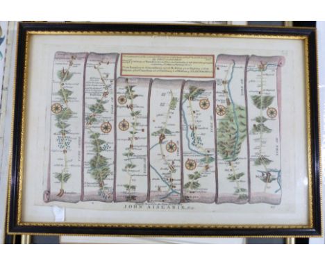
Lot 501
OWEN/BOWEN, 2 hand coloured engraved road maps, 1736, printed recto and verso, comprising THE ROAD FROM YORK TO WHITBY AND SCARBOROUGH, inset map of Westmorland, pages 269-272 + THOMAS GARDNER: THE ROAD FROM MONMOUTH TO LLANBEDR, engraved hand coloured road map circa 1719, sheet 77, approx 170 x 260mm, framed and glazed + THOMAS GARDNER: THE CONTINUATION OF THE EXTENDED ROAD... BARNSLEY TO RICHMOND, engraved hand coloured road map circa 1719, sheet 49, approx 170 x 260mm (4)* vat on buyers premium for this lot *


![JOHN SPEED: DENBIGHSHIRE, engraved hand coloured map [1611], approx 380 x 510mm, framed and glazed* vat on buyers premium for](https://cdn.globalauctionplatform.com/cf7defdc-0625-4ced-8134-ad4200e65693/984cb834-580b-4128-a71b-ad4700f7c95c/468x382.jpg)

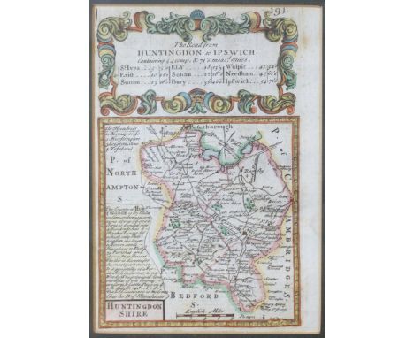
Lot 507
OWEN/BOWEN: 3 hand coloured engraved road maps circa 1736, printed recto and verso, comprising THE ROAD FROM BRISTOL TO WESTCHESTER..., inset map of Herefordshire, pages 143-146, double glazed frame; THE ROAD FROM HUNTINGDON TO IPSWICH..., inset map of Huntingdonshire, pages 193-194 double glazed frame + JOHN OGILBY: THE CONTINUATION ROAD FROM LONDON TO HOLY HEAD, engraved hand coloured road map circa 1698, plate 23, very browned, approx 310 x 430mm, framed and glazed (3)* vat on buyers premium for this lot *
![ROBERT MORDEN: STAFFORD SHIRE, engraved hand coloured map [1695], approx 430 x 365mm, framed and glazed* vat on buyers premiu](https://cdn.globalauctionplatform.com/cf7defdc-0625-4ced-8134-ad4200e65693/0634fec2-0a2f-4de6-82d8-ad4700f7cb91/468x382.jpg)

Lot 509
CHRISTOPHER SAXTON/WILLIAM KIP: WESTMORLANDIAE COMITATUS..., engraved hand coloured map circa 1697, approx 260 x 310mm, framed and glazed + ROBERT MORDEN: WESTMORLAND, engraved hand coloured map [1695], approx 360 x 420mm, framed and glazed + J ROPER after G COLE: DURHAM, engraved hand coloured town plan, 1804, approx 225 x 175mm, framed and glazed (3)* vat on buyers premium for this lot *
![ROBERT MORDEN: ENGLAND, engraved hand coloured map [1695], approx 365 x 425mm, framed and glazed* vat on buyers premium for t](https://cdn.globalauctionplatform.com/cf7defdc-0625-4ced-8134-ad4200e65693/697b1c40-7e3a-4171-9b4b-ad4700f7ccff/468x382.jpg)


![[Hughes, Thomas]. Tom Brown at Oxford, new edition, London & New York: Macmillan and Co., 1871, inscribed by the author '](https://cdn.globalauctionplatform.com/9d88dee8-be88-44ca-9a35-ad3600da6ce4/e285b2a0-2c64-41da-8ca6-ad4900d18b98/468x382.jpg)
Lot 443
[Hughes, Thomas]. Tom Brown at Oxford, new edition, London & New York: Macmillan and Co., 1871, inscribed by the author 'Sybil Irene Cutler with the best wishes of her Godfather the author 1873' to preliminary blank (with later small ink ownership stamp to upper corner of leaf), half-title, vignette title, black & white plates with minor dampstaining to blank margins, a few scattered spots at front, hinges cracked, all edges gilt, together with: Ibid. Alfred the Great, new edition, London: Macmillan & Co., 1873, inscribed by the author 'Sybil Irene Cutler with the best wishes of her Godfather the author 1873' to preliminary blank (spotted and with later small ink ownership stamp to upper corner of leaf), frontispiece map, black & white plates, front hinge cracked, all edges gilt, both in uniform contemporary red morocco gilt, rubbed with some wear to extremities, spines and board edges darkened, some staining (mainly to spine areas), Alfred somewhat marked, 8voQty: (2)
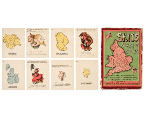
Lot 452
* Anthropomorphic map cards. Skits, A Game of the Shires, London: Jaques & Son, circa 1900, 80 cards (complete), comprising 40 numbered county map cards, and 40 accompanying cards with each county pictured as a person, animal, or object, each with verse, some light spotting and a few marks, and no. 25 (Monmouthsire map) with vertical crease to right-hand side, but edges crisp, pale green versos, 76 x 57mm, lacking 4pp. rule leaflet (supplied in facsimile), contained in original cardboard box with pictorial label on front, some wear to edges, with one hinge splitting, and top edge detached on 3 sidesQty: (1)NOTESExtremely rare. With verses such as: 'Dear Cantabs, old Sambo's our brother,/So every harsh thought we should smother;/Though dark his complexion/He votes at th'election;/Then let us all love one another' and 'What a boon is a notch on the nose/Where the arch of the spectacles goes;/This Staffordshire belle/Its convenience can tell,/For her pince-nez ne'er loses its pose'.
Lot 455
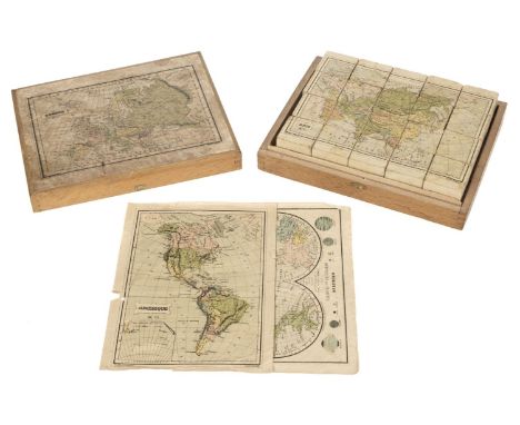
* Victorian Map Block Puzzle. A boxed set of map puzzle blocks, Paris: Charles Verneau, late 19th century, six hand-coloured lithographed maps: Mappemonde, Amerique, Europe, Asie, France, Afrique, dissected and laid on the faces of 20 wooden cubes, dust-soiled and rubbed, some light marks or stains, adhesive starting to fail in places, some edge wear, one section of Amerique with loss, one section of Asie repaired, with two (of 5) loose guide maps (plus Europe map adhered to box lid), dust-soiled and edge-frayed, Amerique map with two longer closed tears, contained in original wooden box, with 'Paris' engraved on the clasp remnant, lacking hinges and clasp, map on lid rubbed and stained, 19 x 24 x 5.5 cmQty: (1)

Lot 456
* World Map Board Game. The Crystal Palace Game, a Voyage Round the World, an Entertaining Excursion in Search of Knowledge, whereby Geography is Made Easy, by H[enry] S[mith] Evans, FRGS, published by Alfred Davis & Co., 58, 59 & 60, Houndsditch, London, [1855?], hand-coloured wood-engraved map of the world, presented as a board game and illustrated with the scenes depicting different activities around the world, sectionalised and laid on linen, some old damp staining with resultant tide lines, 49.5 x 67.5 cm, framed and glazedQty: (1)NOTESScarce. According to Megan A. Norcia, Gaming Empire in Children's British Board Games, 1836-1860, Routledge, 2019, page 23 '... though Evans' Crystal Palace Game seems to be about the 1851 exhibition, itself a display of the Empire's power and benevolence in developing arts and manufactures, the way Evans addresses this topic demonstrates that his game is really promoting British emigration and colonization by presenting opportunities to gain wealth in the colonies'.

Lot 521
Chatwin (Bruce). In Patagonia, 1977; The Viceroy of Ouidah, 1980; On the Black Hill, 1982; The Songlines, 1987; Utz, 1988, 1st editions, Songlines textblock a little toned, map endpapers to In Patagonia and Viceroy, original cloth, dust jackets, some fading to In Patagonia and On the Black Hill spines, 8vo, together with 15 others by Chatwin including The Morality of Things, 1993 (limited edition of 175), The Attractions of France, Colophon Press, 1993 (limited edition 77/175) What Am I Doing Here, 1989, Photographs and Notebooks, 1993, and Anatomy of Restlessness, 1996Qty: (20)

Lot 549
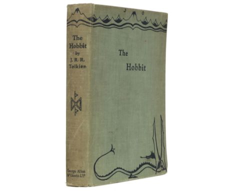
Tolkien (J.R.R.) The Hobbit or There and Back Again, 1st edition, 2nd impression, London: George Allen & Unwin, 1937, colour frontispiece, colour and monochrome plates and illustrations, map endpapers (slightly toned), original green pictorial cloth, spine a little toned and rubbed at ends, slight lean, 8voQty: (1)NOTESThe second impression, published in the same year as the first, and the first with the colour plates.
Lot 575
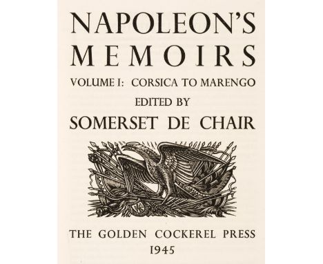
Golden Cockerel Press. Napoleon's Memoirs, edited by Somerset de Chair, 2 volumes, Golden Cockerel Press, 1945, wood-engraved title vignettes by John Buckland-Wright, map endpapers, top edge gilt, original green cloth gilt, a few faded areas, folioQty: (2)NOTESLimited edition 233/500. Presentation inscription to volume I frontispiece verso: "Presented to Dr G.E. Burton, as a token of appreciation and esteem by the Sawbridge A.R.P. First Aid Parties 1939-1946."

Lot 589
Chivers (Cedric). The Sundering Flood, by William Morris, 1st trade edition, Longmans, Green, and Co., 1898, half-title, single-page map, single-page publisher's advertisement leaf at rear, a few light spots, top edge gilt, remainder rough-trimmed, contemporary painted vellucent vellum by Dorothy Carleton Smyth (1880-1933) for Cedric Chivers of Bath, binder's embossed stamp to preliminary blank, artist's monogram DS with dodo motif painted in black to foot of spine, covers very slightly bowed, spine with title lettered in black, gilt flower and seedhead roll to turn-ins, 8voQty: (1)NOTESOf the five women used by Chivers to design, illuminate and colour vellum bindings, Dorothy Smyth was the one 'most frequently employed for this kind of work.' (Tidcombe, Women Bookbinders, 1996, page 86).

Lot 635
Hardy (Thomas). Tess of the D'Urbervilles. A Pure Woman, London: Macmillan and Co., 1926, 41 wood-engravings by Vivien Gribble, folding map of Wessex by Emery Walker, uncut, original vellum-backed boards, dust jacket, 4toQty: (1)NOTESPurdy 77. Limited edition, one of 325 large paper copies, signed by the author. A good copy in the scarce dust jacket.

Lot 660
Nonesuch Press. The Writings of Gilbert White of Selborne, selected and edited with an introduction by H.J. Massingham, 2 volumes, Nonesuch Press, 1938, wood-engraved additional titles and illustrations by Eric Ravilious, folding map, a little minor spotting, top edge gilt, original grey buckram gilt, spines faded, foot of spines a little bumped, 8voQty: (2)NOTESLimited edition 495/850. Provenance: Laurence Frederic Fitzhardinge (1908-1993), Australian author and librarian, his small booklabel.


-
109182 item(s)/page