We found 109198 price guide item(s) matching your search
There are 109198 lots that match your search criteria. Subscribe now to get instant access to the full price guide service.
Click here to subscribe- List
- Grid
-
109198 item(s)/page


Lot 133
A collection of four hand coloured Victorian engraved maps of England published by Thomas Moule (English, 1784 – 1851). The lot comprising a map of Hertfordshire, a map of Dorsetshire engraved on steel, a map of Buckinghamshire and a map of Devonshire. All maps framed and glazed. Largest measures approx. 35cm x 39m.

Lot 160
Military interest - a large collection of officer's guides and manuals. The lot to include Manual of Army Catering Services 1954, The Drill Manual 1990, UK Restricted Rifle and Machine Gun and Light Support Weapon operating information 1987, Exercises based on Military Map Reading for the New Army 1941 fifth ed., Notes on Map Reading 1929 Official Copy, Drill (All Arms) 1965, 1953 The Petty Officer's Guide by Cope and Dyer, Field Service Pocket Book Pamphlet No. 3 1939 - Intelligence Information and Security, 1914 Torpedo Drill Book (damaged & ink stained to leaves), 1860 Drill and Rifle Instruction for the Corps of Rifle Volunteers, and others. Majority 20th century, some earlier.


Lot 496
A BOX AND LOOSE MAPS AND PRINTS ETC, maps include a map of Massachusetts, Connecticut and Rhode Island published 1832, approximate size 20cm x 26cm, various 18th & 19th century Staffordshire including Meeting places of the Hoar-Cross Hunt, Thomas Gardner road maps Bristol to West Chester and Oakham to Richmond, John Ogilby road map London to Holy Head, with John Carey maps of Hampshire and Dorsetshire dated 1818, C.S. Smith maps of Northumberland, Cumberland and Westmoreland dated 1801, pictures include an architectural study of bridge houses by Joseph Moussa, watercolour on paper, approximate size 16cm x 23cm, a limited edition print depicting Timoleague Friary by Nevil Swinchatt, an etching of a street in Hong Kong, Indian painting on fabric depicting three elephants, reproduction cigarette cards etc. (1 BOX + loose)

Lot 1769
Collection of antique and later maps, mostly unframed to include, Persia & Arabia, publ. 1825, A & S Arrowsmith, Australia, engraved by FP Becker, hand coloured map of Taiwan and Chart of the Society Isles discovered by J Cook, 1769, together with a hand coloured engraving of Captain Cook, publ. 1800


Lot 464
5 British Rail (Southern), LT, Network Southeast Railway Carriage Route Panels. 1066 and Country 1970s Hastings Line Map (vinyl) 24x16 inch approx, NSE Area Routes Diagram 1992 (card) 17x17 inch approx, NSE London Connections Route Diagram 1992 (card) 17x17 inch approx, LT Central London Route Diagrams 1991 and 2011. Good condition. Est


Lot 509
A Particular Account of the European Military Adventures of Hindustan T. Fischer Unwin New York 1893 Pictorial boards. 419 pages, 7 black and white illustrations and a fold out map. English Covers soiled. Internally clean. Provenance: From the Library of the Late Peter Curnow Millett (1925-2016)

Lot 514
The Hand-Book of India, a Guide to the Stranger and the Traveller, and a Companion to the Resident W M Allen & Co. London 1844 Full calf. 600 pages, a fold out map. English Cover worn, leather label on spine peeling. Foxing on the flyleaves, internally clean. Provenance: From the Library of the Late Peter Curnow Millett (1925-2016)

Lot 618
Four Guide Books for India India c1956,57,61 Paperbacks. Guide to Cochin: 151 pages, black and white illustrations including a fold-out map; Mysore and Kerala: 108 pages, black and white illustrations; A Guide for Tourists Vrindaban, Mathura & Brij: 56 pages, colour frontispiece; A Guide to Sravana-Belgola: 50 pages, black and white illustrations. English Good, used condition. Provenance: From the Library of the Late Peter Curnow Millett (1925-2016)
Lot 396
Manual of Coorg. A Gazetteer of the Natural Features of the Country and the Social and Political Condition of its Inhabitants C. Stolz Mangalore 1870 Boards. 474 pages, 4 illustrations and 1 folding map English Wear to covers, texblock shaken, some loose pages, tear to the bottom of the frontispice, not affecting the plate Provenance: From the Library of the Late Peter Curnow Millett (1925-2016)

Lot 493
Lumsden of the Guides: A sketch of the life of Lieut.-Gen. Sir Harry Burnett Lumsden, KCSI CB with selections from his correspondence and occasional papers. John Murray London 1899 Pictorial cloth boards. 333 pages, 8 black and white illustrations with two figures, one facsimile letter and a fold out map. With bookplate on upper pastedown. English Covers with minor wear. Some foxing. Provenance: From the Library of the Late Peter Curnow Millett (1925-2016)


Lot 499
Bombay and Western India: A Series of stray papers Sampson Low, Marston & Company London 1893 Pictorial boards. Volume I: 472 pages, black and white plates and illustrations throughout including frontispiece with a fold-out map. Volume II: 414 pages, black and white plates and illustrations. English Covers worn and soiled. Inside pages clean. Provenance: From the Library of the Late Peter Curnow Millett (1925-2016)


Lot 480
OF THE MANNERS AND CUSTOMS OF THE LOCAL HILL TRIBES Newman's guide to Darjeeling and neighbourhood a historical and descriptive handbook with an account of the manners and customs of the local hill tribes W. Newman & Co. Calcutta 1919 Illustrated wrappers. 124 pages, four black and white illustrations and a fold out map. English Good, used condition. Minor tear to spine. Provenance: From the Library of the Late Peter Curnow Millett (1925-2016)

Lot 508
Vedic India: As Embodied Principally in the Rig-Veda T. Fisher Unwin London 1899 Pictorial boards. 457 pages, fold out colour frontispiece, a fold out map and various black and white illustrations. English Covers worn. Internally clean. Provenance: From the Library of the Late Peter Curnow Millett (1925-2016)

Lot 555
Rambles and Recollections of an Indian Official, Major-General Sir W. H. Sleeman K.C.B. Humphrey Milford, Oxford University Press 1915 Cloth boards. Revised annotated edition. 667 pages, black and white frontispiece and a fold-out map English Cover worn. Spine slightly loose. Internally clean. Provenance: From the Library of the Late Peter Curnow Millett (1925-2016)

Lot 619
The Gazetteer of Bombay City and Island Vols I-III The Times Press Bombay 1909-1910 Hardbacks. Vols II-III original cloth boards, Vol I rebound. Vol I: 520 pages, black and white plates and illustrations throughout; Vol II: 492 pages, 1 colour map, black and white plates and illustrations throughout; Vol III: 384 + xxxix pages, black and white plates and illustrations throughout. English Covers worn and soiled. Some plates loose. Internally clean. Provenance: From the Library of the Late Peter Curnow Millett (1925-2016)

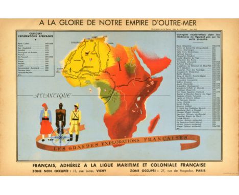
Lot 350
Original vintage World War Two propaganda poster - A la gloire de notre empire d'outre-mer Francais adherez a la ligue maritime et coloniale francaise / To the glory of our overseas empire The French join the French Maritime and Colonial League - issued by Mer et Colonies / Sea and Colonies in May 1942 featuring a map of France's explorations in Africa marking various places including Dakar, Tripoli, Alger, Casablanca, Tunis with French flags, an elephant, palm tree and ships at sea and three people standing next to the compass point and decorative banner ribbon reading Les Grands Explorations Francaises / The Great French Explorations. Horizontal. Printed in Lyon France. Excellent condition. Country of issue: France, designer: Unknown, size (cm): 20.5x46.5, year of printing: 1942.

Lot 429
Original vintage Chinese Communist Party propaganda poster commemorating the 60th anniversary of the founding of the party - 1921-1981 Without the Communist Party, There Would Be No New China / ????? ?????? - featuring an illustration of a rainbow, radiant hammer and sickle shining on the outline of the map of China, with the Forbidden City marking Beijing on the map. Published by Jiangsu People's Publishing House. Good condition, creasing, foxing. Country of issue: China, designer: Pan Xiaoqing, size (cm): 77x53, year of printing: 1981.
Lot 299
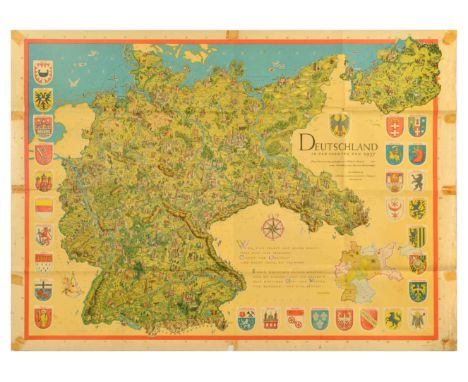
Set of 3 original vintage maps and prints. 1. Map of Germany with explanatory notes below in the legend marking the state frontiers, Germany's 1937 frontiers, boundaries of the Lander in the Federal Republic of Germany and the demarcation line between the Federal Republic and the Soviet-occupied zone of Germany. Prepared on the basis of the specifications adopted at the UN Technical Conference on the International Map of the World on the Millionth Scale 1962. Edited and published by Institut fur Angewandte Geodasie, Frankfurt a. Main. Horizontal. Large size. Good condition, folds, pinholes, tears, creasing, staining, browning. Country of issue: Germany, designer: Unknown, size (cm): 101.5x136, year of printing: 1965; 2. Illustrated map poster for Germany / Deutschland showing the country in the borders of 1937, this map was created by Wilhelm Neufeld with the collaboration of Martin Kornrumpf and published by Muller Kiepenheuer Verlag. Design features detailed pictorial maps showing cities, rivers, mountains, buildings, animals, and people, surrounded by coats of arms from major German cities, with a quote from Goethe below the compass - Anyone who knows themselves and others will also recognise here: Orient and Occident can no longer be separated. It makes sense to move between the two worlds, so moving between East and West is for the best. Horizontal. Large size. Fair condition, folds, tears, paper losses, staining, tape marks on edges, pinholes. Country of issue: Germany, designer: Wilhelm Neufeld, Martin Kornrumpf, size (cm): 89x124, year of printing: 1937; 3. photograph of St Bartholomew's Church in Konigssee, Bavaria, depicting the Roman Catholic church on the shore of Konigssee Lake at the feet of Alpine mountains. Published by the German National Tourist Office, Frankfurt-Main. Good condition, creasing, small tears. Country of issue: Germany, designer: Unknown, size (cm): 74x50, year of printing: 1970s.

Lot 345
Original vintage post-World War Two poster Berlin - British Sector, featuring a map depicting the city of Berlin in the aftermath of WWII marking French, Russian, American and British Sectors, railways, S Bahn, U Bahn and buildings occupied by Allied Forces. Horizontal. Large size. Good condition, folds as issued, tears on edges, minor staining, pinholes, creasing. Country of issue: Germany, designer: Unknown, size (cm): 120x86, year of printing: 1940s.

Lot 236
Original vintage advertising poster for Les Vignobles de France Vins de Bordeaux / The Vineyards of France Bordeaux Wines featuring a pictographic map of the Bordeaux wine region with colourful illustrations of people in traditional and ceremonial dress, decorative grapes and vines, historical chateau buildings and an industrial image of a cargo ship in a harbour by the Gironde estuary with wooden wine barrels in the foreground, the roads, rivers, town and city details of the Bordeaux region in the centre, the bold red title text above and coat of arms with the featured area highlighted below. Published by SOPEXA Comite Nationale de Vins de France / the National Committee of the Wines of France. Horizontal. Good condition, folds, tears, creasing, staining. Country of issue: France, designer: Unknown, size (cm): 67x94, year of printing: 1960s.
Lot 158
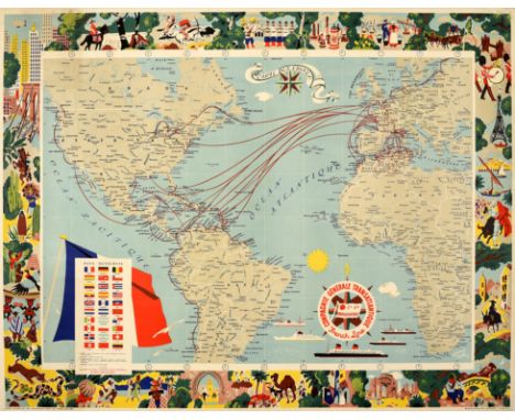
Original vintage travel advertising poster for the Compagnie Generale Transatlantique (founded 1861) featuring a decorative world map with the Atlantic Ocean in the centre highlighting the routes between Europe and North Africa to the Americas with a chart showing the flags of various countries in front of the French flag on the Pacific Ocean, the CGT French Line logo on the compass point above illustrations of ships with a yellow sun shape against the blue sea and a banner above with the title Carte Des Lignes (Route Map), all surrounded by a colourful illustrated border featuring imagery from different countries including historical and notable architecture such as the Eiffel Tower in Paris and New York skyscrapers, animals and wildlife, people on horses and depicting local traditions and daily life activities, sailing on the River Nile in Egypt, music bands marching, bullfighting in Spain and other scenes. Horizontal. Good condition, restored paper losses in margin, pinholes, minor staining, backed on linen. Country of issue: France, designer: Blondel La Rougery, size (cm): 78x100, year of printing: 1959.

Lot 300
Original vintage fold-out travel map - Tourist Plan of Johannesburg - featuring a detailed map of the city showing railway stations, tram, and bus routes and terminals, roads, parks and sports grounds, municipal swimming baths and lakes, buildings, churches and view sites. Compiled and Drawn by Capt. P.C. PAFF, DTD. (Pretoria Map Office) Printed in The Union of South Africa by the Government Printer, Pretoria. Horizontal. Good condition, folds as issued, creasing, staining, double sided. Country of issue: South Africa, designer: Capt. P.C. Paff, size (cm): 48.5x59, year of printing: 1920s.

Lot 235
Original vintage advertising poster for Les Vignobles de France Languedoc Roussillon Cotes de Provence et Corse / The Vineyards of France Languedoc Roussillon Cotes de Provence and Corsica featuring a pictographic map of the Languedoc (now the Occitanie region), Roussillon (formerly Catalonia and now part of the Occitanie region) and Corsica wine regions with colourful illustrations of people in traditional clothing depicting a man carrying a basket of grapes on his back, men playing music and a lady dancing in front of stone arches and views of a windmill in a field, the ancient Pont du Gard Roman aqueduct over the Gardon River and a chateau above a map of the roads, rivers, towns and city details including Carcassone Perpignan Nimes Avignon Montpellier Marseille Draguignan Nice and Ajaccio with images on the Mediterranean Sea of wooden rowing boats moored by an historical harbour tower, fishing boats in front of a coastal town and a sailing boat on the calm water between rocky hills, the bold red title text above and coat of arms with the featured area highlighted below. Published by SOPEXA Comite Nationale de Vins de France / the National Committee of the Wines of France. Horizontal. Good condition, folding, tears, creasing. Country of issue: France, designer: Unknown, size (cm): 67x94, year of printing: 1960s.

Lot 233
Original vintage advertising poster for Les Vignobles de France Vins de Champagne / The Vineyards of France Wines of Champagne featuring a pictographic map of the Champagne wine region framed by an illustration of a lady gathering grapes from a vine with stylised images of the ancient and historic city buildings and a champagne bottle and flute glass in front of a shining sun behind a map showing the vineyards of Montagne de Reims Vallee de la Marne Epernay and Cote Des Blancs with the rivers, roads and town and city details, the bold red title text above and coat of arms with the Champagne area highlighted below. Published by SOPEXA Comite Nationale de Vins de France / the National Committee of the Wines of France. Horizontal. Good condition, folds, pin holes. Country of issue: France, designer: M.S. Dutter, size (cm): 67x94, year of printing: 1960s.
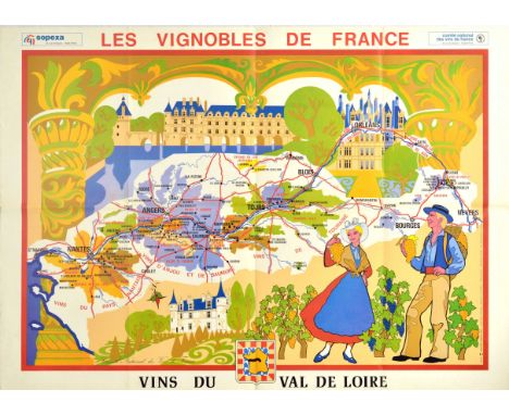
Lot 234
Original vintage advertising poster for Les Vignobles de France Vins du Val de Loire / The Vineyards of France Wines of the Loire Valley featuring a pictographic map of the Loire Valley wine region with a colourful illustration of a smiling man carrying a basket of grapes on his back and a lady in traditional dress holding up grapes in a chateau vineyard by a formal garden and trees and decorative compass point, the top framed by fleur de lis arches with columns on the sides and historic buildings over the water above the roads, rivers, town and city details of Nantes Angers Tours Bourges Nevers and Blois, the bold red title text above and coat of arms with the Val du Loire area highlighted below. Published by SOPEXA Comite Nationale de Vins de France / the National Committee of the Wines of France. Horizontal. Good condition, folds, creasing, staining, tears. Country of issue: France, designer: Unknown, size (cm): 67x94, year of printing: 1960s.

Lot 237
Original vintage advertising poster for Les Vignobles de France Vins des Cotes Du Rhone / The Vineyards of France Cotes Du Rhone Wines featuring a pictographic map of the Cotes Du Rhone wine region showing the roads, rivers, town and city details of Vienne Tournon Valence Orange and Avignon between colourful illustrations of men picking grapes and carrying baskets below a stylised sun over an old stone bridge reflected in the water on one side and ladies in traditional dress gathering grapes in hand held baskets on the other side decorated with grapes and vines, the bold red title text above and coat of arms with the featured area highlighted below. Published by SOPEXA Comite Nationale de Vins de France / the National Committee of the Wines of France. Horizontal. Good condition, folds, tears, staining, creasing. Country of issue: France, designer: M.S. Dutter, size (cm): 67x94, year of printing: 1960s.
Lot 232
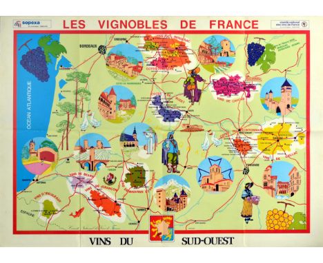
Original vintage advertising poster for Les Vignobles de France Vins du Sud-Ouest / The Vineyards of France Wines from the South West featuring a pictographic map of South West France with the Atlantic Ocean on the side, showing the major wine regions and vineyards of Bordeaux Bergerac Cahors Buzet Frontonnais Gaillac Bearn D'irouleguy Jurancon and Madiran with colourful illustrations of ancient and historic landmarks, buildings and bridges, a monk holding a glass of wine to drink in a monastery, wine barrels, people in historical and national dress, bunches of grapes on vines, roads, rivers, trees, fish and geese, and regional town and city details, the bold red title text above and coat of arms with the South West Armagnac area highlighted below. Published by SOPEXA Comite Nationale de Vins de France / the National Committee of the Wines of France. Horizontal. Good condition, folds, staining, creasing. Country of issue: France, designer: Unknown, size (cm): 67x94, year of printing: 1960s.

Lot 359
Original vintage propaganda poster for the post-war US sponsored European Recovery Program (1948) known as the Marshall plan - ERP Prosperity The Fruit of Cooperation European Recovery Programme - featuring a great design by Brian E Dear depicting a hand as a map of Europe folding around to hold a ripe red fruit with the stylised text diagonally above and below. This design was submitted to the Intra-European Cooperation for a Better Standard of Living poster competition on the theme of cooperation and economic recovery that was held in Europe for the Marshall Plan. Printed by Kühn Zoon Rotterdam. Good condition, restored tears in margin, creasing, minor staining in margin. Country of issue: Netherlands, designer: Brian E Dear, size (cm): 75x55, year of printing: 1950.


-
109198 item(s)/page