We found 109182 price guide item(s) matching your search
There are 109182 lots that match your search criteria. Subscribe now to get instant access to the full price guide service.
Click here to subscribe- List
- Grid
-
109182 item(s)/page


Lot 5351
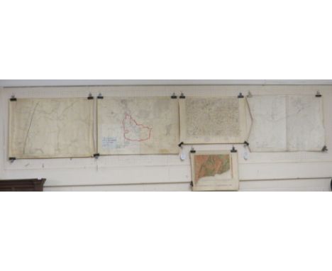
WW1 British Map collection. A large extensive collection of approx 70 maps many bearing Officers names to the front and penciled notes. Covering such famous battle areas as Ypres, Arras, Mons, Cambrai, etc. Including eight Trench maps: Belgium sheet 28 NW edition 3D, Zonnebeke 28 NE1, edition 7A, France Sheet 28 SW edition 5A, Trench map sheet 36 SW3: Trench map sheet 57C SW edition 4A: Trench map 36c NW1 provisional edition No.2: Belgium sheet 28 SW & SE edition 1A: France sheet 57b.


Lot 550
An RAF operations room wall clock** made by F.W Elliott Ltd, England (stamped to backplate). The pale cream dial has twenty-four hour Roman numerals, RAF 'King's Crown' warrant officers insignia to top centre and red, blue and yellow sector markings. With blued steel spade hands. The mahogany case has brass bevel framing glass door. Eight-day, single train movement. 45 cm diameter. **These sector clocks were widely used during World War II to help track the movements of enemy aircraft. The position of the aircraft was recorded in conjunction with the coloured triangle segment beneath the minute hand at the time of sighting. This information was then fed back to HQ where corresponding coloured counters were then placed on a large table map of Britain overlaid with the national grid system and moved across the map by magnets, thus representing an air-raid. This enabled quicker responses to identify possible targets and launch counter-attacks. For a condition report please visit our website www. peterwilson.co.uk


Lot 81
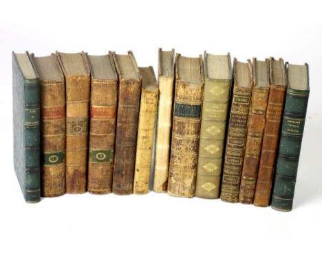
HOUSMAN JOHN. A Topographical Description of Cumberland, Westmorland & Lancashire & a Part of the West Riding of Yorkshire. Fldg. & other eng. plates & plans. Rubbed half morocco. Carlisle, 1809; also Britton & Brayley, A Topographical & Historical Description of the County of Cumberland, eng. fldg. map & eng. plates, blank interleaves, rebacked calf, c.1805. Both ex lib. with stamps & labels. (2).

Lot 138
PATTERSON ARTHUR H. Rough Notes on the Fish & Fisheries of East Suffolk. Ltd. ed. 65/111. 3 photo plates, map & 12 plates after sketches. Orig. prntd. brds., internal browning & spotting. Pres. copy from the author, Private Circulation, Great Yarmouth, 1910; also a related offprint by Patterson. (2).


Lot 74
LINCOLN W. J. The Ferns of the English Lake Country. 2 copies. Col. frontis & other illus. Orig. green cloth, internal foxing & spotting. Ex lib. with stamps & labels. 1865; also J. Postlethwaite, The Geology of the English Lake District, pres. copy from the author, fldg. map, illus., orig. pict. brds., 2nd ed., Carlisle, 1906. (3).


Lot 79
(WEST THOMAS). A Guide to the Lakes. Eng. fldg. map & eng. plate. Orig. brds., lib. label inside upper brd. & stamp to reverse of title. 1796; also the 1821 edition of the same with col. aquatint frontis, orig. marbled brds., label inside upper brd. (2). Condition Report. 1796 edition - Lacking a plate.1821 edition - Lacking a map.


Lot 113
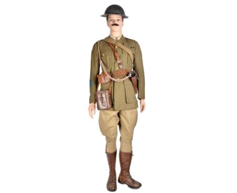
A uniform exhibit, comprising: a mannequin dressed as an officer of the Prince of Wales Own West Yorkshire Regiment, complete with Sam Browne belt with whistle, replica revolver in holster and with lanyard, 1917 dated ammunition pouch, cased binoculars, haversack, map case, Ingersoll pocket watch, and Brodie pattern helmet.

Lot 1310
Military Ephemera - Seat of War map, published by Laurie & Whittle, London, A New Map of the Emperors Dominion exhibiting The Post Roads of Germany, Hungary and the Netherlands with thofe of the Adjacent Parts of France, Switzerland, Italy and Poland, linen, marbled slip; Army Book, 136a; Military Books; Christmas and New Year folding paper, H.M. Forces; Trench Sketch; etc


Lot 735
Travel interest: Coxe (Wm.) Travels in Switzerland, 2 vols D. 1789. First Dublin Edn., cont. tree calf; Damberger (Christian Fred.) Travels in the Interior of Africa, from Cape of Good Hope to Morocco, 2 vols. in one, 8vo D. 1801., 3 plates (lacks map), qtr. mor.; Anderson (Aeneas) A Narrative of the British Embassy to China, 8vo D. 1796, Second Edn., hf. title, hf. calf; Lloyd (H.E.) Alexander I, Emperor of Russia, 8vo L. 1826 Hf. title, port. frontis & map, qtr. mor.; & 7 others. As a lot. (1)


Lot 1818
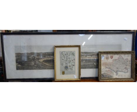
AM Sergent (early 20th century British school) - Sunset landscape with figures round a camp fire, oil on canvas, signed and dated 1908, 30 x 45cm, framed, together with an 18th century black and white map of England by Robert Morden, 40 x 45cm, a further map of the Environs of Bath and Bristol and a Silcocks advertising calendar for 1932

Lot 369
Ordnance Survey map outlining the parish of Little Hallingbury and Saffron Waldon division 1921 and 1923 edition, Geological Survey map of Sidmouth 1906, Ordnance Survey map of Lambrook 1903 edition, Grid map of Chard and Axminster, and pages from The Times newspaper dated Friday May 1, 1936


-
109182 item(s)/page