We found 109182 price guide item(s) matching your search
There are 109182 lots that match your search criteria. Subscribe now to get instant access to the full price guide service.
Click here to subscribe- List
- Grid
-
109182 item(s)/page


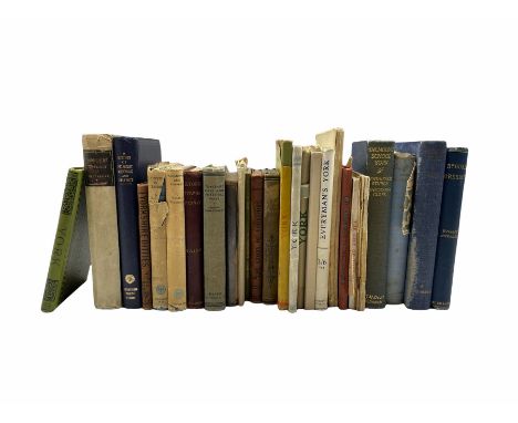
Lot 600
A large quantity of assorted maps, aerial photographs, training material etc from the Directorate of Overseas Surveys. Established after the Second World War, DOS was responsible for mapping those parts of the British Empire, and latterly countries throughout the Commonwealth, which had no survey capability of their own. DOS contracted wide ranging aerial surveys of each country, to provide a basis for cartography. In turn, the cartography and aerial images helped to inform the development and administration of each country. Included within the lots are various photographs, preliminary map acetates, film negatives from a range of countries including Rhodesia, Gambia, Kenya, Paraguay, Mauritius.


Lot 132
SIMPSON J. Y. Side-Lights on Siberia, Some Account of the Great Siberian Railroad, the Prisons & Exile System. Illus. & fldg. map (map torn at hinge). Orig. pict. green cloth gilt, internal foxing & spotting. 1898; also Henry Seebohm, Siberia in Europe, illus. & fldg. map, orig. pict. blue cloth, 1880 & Algernon Noble, Siberian Days, illus., blue cloth, 1928. (3).


Lot 164
GREELY ADOLPHUS W. Three Years of Arctic Service, An Account of the Lady Franklin Bay Expedition of 1881-84 & the Attainment of the Farthest North. 2 vols. Many plates & illus. Large fldg. map (tape reps.) in end pocket (end pocket split open). Recased orig. blue pict. cloth, internal foxing & spotting. 1st ed., New York, 1886.


Lot 105
Cheshire. Speed (John), The County Palatine of Chester with that most ancient Citie described, sold Bassett & Chiswell, [1676], hand-coloured engraved map, inset town plan of Chester, strapwork cartouche and mileage scale, English text on verso.40cm x 51.5cm (15.75in x 20.25in)Condition report: The map is in good, original condition. The paper has browned in some areas. The map is framed and glazed on both sides. The frame has some minor scuffs and knocks commensurate with age.
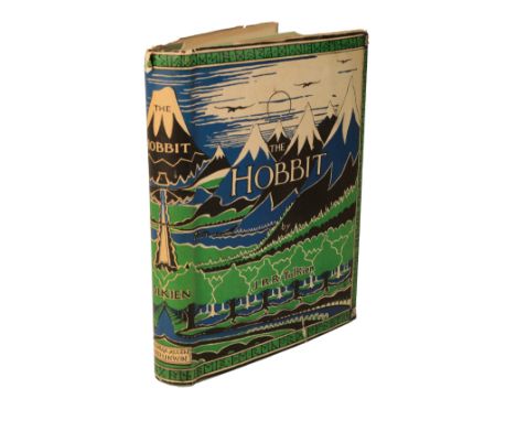
Lot 46
TOLKEIN, J.R.R. 'The Hobbit, or There and Back Again' 1st ed., 1st impression, pub. Allen & Unwin, 1937, ten uncoloured illustrations by J.R.R. Tolkien, advertisement at rear, map endpapers printed in red and black, original green cloth, covers and spine with wraparound dark blue illustration of mountains, moon and sun at top, upper cover with Smaug illustration looking left, original first impression dust-jacket with 'Dodgeson' (better known as Lewis Carroll) manual correction on lower flapProvenance: A Dorset Family of TitleJ.R.R. Tolkien's award-winning fantasy novel was published on 21 September 1937, with 1500 copies printed, which sold out by 15 December. Originally concieved in the late 1920's-early 1930's to entertain his three sons, Tolkien recalled in 1955 in a letter to W.H. Auden: 'All I can remember about the start of The Hobbit is sitting correcting School Certificate papers in the everlasting weariness of that annual task forced on impecunious academics with children. On a blank leaf I scrawled: "In a hole in the ground there lived a hobbit." I did not and do not know why. I did nothing about it, for a long time, and for some years I got no further than the production of Thror's Map. But it became The Hobbit in the early 1930's...'. The book has gone on to sell an estimated 100 million copies worldwide since first publication and was never out of print. Tolkien began work on The Lord of the Rings in December 1937 after publishers George Allen & Unwin encouraged the author, against his inclination, to write a sequel


Lot 353
RAILWAYANA - ASSORTED PUBLICATIONS & EPHEMERAcomprising four booklets on the locomotives of the L.B. & S.C.R.; G.W.R. Rule Book, 1913; S.R. Appendix to Working Time Tables, 1934; G.W.R. Regulations for Train Signalling, 1936; G.W.R. General Appendix to the Rule Book, 1936; an L.M.S. system map, 1928; G.W.R. system map, circa 1930s; and other items, (box).
![[MAPS] Morden, Robert (c.1650-1703), 'Somerset', engraved county map, hand-coloured in outline, 38.5cm x 45cm, framed and gl](https://cdn.globalauctionplatform.com/9d10a326-5134-4abd-8fd4-ad9c011426ce/ddd2114d-ee9f-46bc-b6de-adb400b89189/468x382.jpg)
Lot 448
[MAPS] Morden, Robert (c.1650-1703), 'Somerset', engraved county map, hand-coloured in outline, 38.5cm x 45cm, framed and glazed. Condition Report : Generally good condition, with fresh colours; small hole and associated tears to upper right corner of margin; 11cm flattened print crease to mid right edge. Condition reports are offered as a guide only and we highly recommend inspecting (where possible) any lot to satisfy yourself as to its condition.

Lot 907
A large vintage retro mid 20th century hydrographic Office map “ The Port of London Authority “ depicting “ Port Of London Authority Plan Of The Dock “ and “ Port Of London - The River Thames From Teddington To The Nore “ by Cook, Hammond & Kell LTD Mitcham And Westminster. Measures 70cm high x 105cm wide (without frame measures)


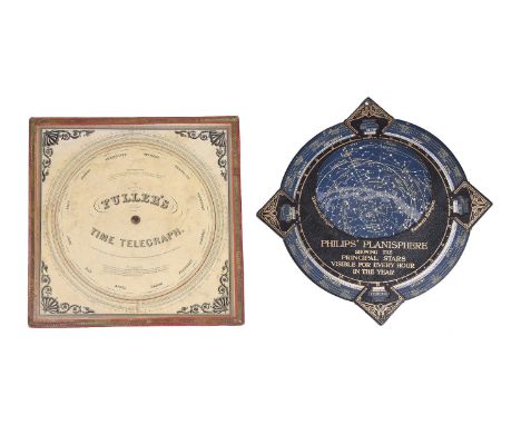
Lot 75
A PALMER'S COMPUTING SCALE AND FULLER'S TIME TELEGRAPH CIRCULAR SLIDE RULEPrinted by John E. Fuller, Boston, 1847The first side labelled PALMER'S, COMPUTING SCALE, IMPROVED BY, FULLER. and variously inscribed with accreditations including Entered according to Act of Congress in the year 1843 by Aaron Palmer in the Clerks Office of the District Court of the State of Massachusetts, and by J.E. Fuller 1847, over Engraved by George G. Smith, 188 Washington St. Boston to the centre of the revolving disc annotated with various computational scales with instruction Use the inner circle for Dollars, Cents & Mills, or Pounds Shillings & Pence, the reverse labelled FULLER'S, TIME TELEGRAPH with accreditation Entered according to Act of Congress in the year 1847 by John E. Fuller in the Clerks Office of the District Court of the State of Massachusetts, over Engraved by G.G. Smith, Boston to the centre within scales divided for annual calendar revolving within various computational scales to allow calculation of numbers of days or weeks between two dates and with two blocks of text titled Directions for weeks and Directions for days, with anthemion and scroll printed spandrel decoration to angles, with a PHILIPS' PLANISPHERE by George Philip and Son Limited, London, early 20th century with circular card printed with celestial map within outer calendar scale rotating within sleeve pierced with aperture for revealing the nights sky at any given date of the year labelled in gilt PHILIPS' PLANISPHERE, SHOWING THE PRINCIPAL STARS, VISIBLE FOR EVERY HOUR, IN THE YEAR to centre and with EXPLANATION test to verso (2).The circular slide rule 28.5cm (11.25ins) square; the planisphere 12.25ins (31cm) wide. Provenance: The horological library of Lawrance Hurst.

![[King James Bible] The Holy Bible containing the Old Testament and the New, newly translated out of the original Tongues and](https://cdn.globalauctionplatform.com/ed7b5fa9-76ca-4bf3-a6c8-adb1009d46c2/0e13778f-0fbe-4315-916d-adb100dc307d/468x382.jpg)
Lot 239
[King James Bible] The Holy Bible containing the Old Testament and the New, newly translated out of the original Tongues and with the former translation diligently compared and revised; by His Majesties speciall commanderment printed by Robert Barker and John Bill 1631, the first page with engraved illustration of Adam and Eve followed by 27 sides printed with genealogies, engraved title page, The New Testament with engraved title page (dated 1631), with an engraved title page and few pages for The Whole Book of Psalms (dated 1631), lacks binding, no title to Genealogies and believe some tables lacking with one damaged, no map present, first section loose and ink names at end of New Testament (1)

Lot 181
The Unknown Horn of Africa, An Exploration from Berbera to the Leopard River by F.L. James with map and drawings, published George Philip 1888 first edition in gilt picture cloth, A Course of Water-Colour Painting by R.P. Leitch with 24 coloured plates published Cassell (c1880s) with tipped in coloured plates in original gilt cloth (2)


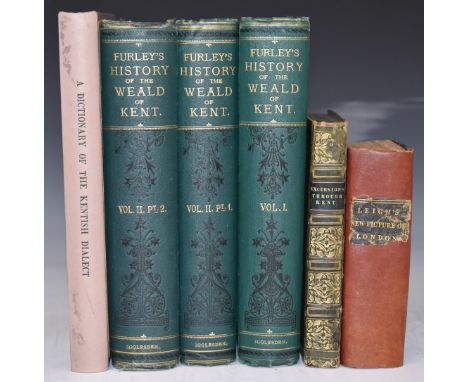
Lot 150
A History of The Weald of Kent, with an Outline of the Early History of the County by Robert Furley with sketch of the Physical Features by Henry B. Mackeson 1871 in 2 volumes (bound in 3) with folding plates bound in publisher's gilt cloth, Excursions in the County of Kent with Historical & Topographical Delineations, Residences of the Nobility & Gentry with Guide for Traveller etc 1822 with 47 (of 50) engravings including a map in full gilt leather, Dictionary of the Kentish Dialect by Parrish & Shaw 1888, Leigh’s New Picture of London (c.1820) with engravings and folding maps (l0.acking prelims and title page) re-spined with gilt lettered boards (6)
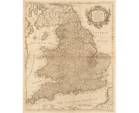
Lot 128
Seale (R. W.). A collection of 13 maps, circa 1745, uncoloured engraved double-page maps, charts and town plans, slight spotting, each approximately 485 x 395 mmQty: (13)NOTESThe maps consist of - The Kingdom of Ireland, England and Wales, Views of the Principal Towns and Castles in Scotland, A Correct Chart of St George's Channel and the Irish Sea, A Correct Chart of the English Channel, Plans of the Towns, Forts and Harbours in Ireland, A Map of France, A Correct Chart of the Baltick (sic) or East Sea, A Map of the Kingdoms of Spain and Portugal, A Map of Italy, A Map of South America, A Correct Chart of the Bay of Biscay, Part of the Western Ocean & Mediterranean Sea..., [and] A Correct Chart of the German Ocean.

Lot 137
World. Carington Bowles (publisher), A New and Accurate Map of the World from the latest Surveys, circa 1770, engraved map on a hemispheral projection with contemporary outline colouring, insular California, old folds, short split at the base of one fold, slight soiling and staining, 305 x 530 mmQty: (1)
-
109182 item(s)/page