Yorkshire. Ordnance Survey maps, scale of 6 inches to one mile, sixteen sheets, first edition 1853 - 1857, sixteen double page uncoloured engraved maps, each laid on later linen, slight dust soiling, later endpapers with library book plate and ink stamps, one ink stamp to margin of first map, each map approximately 640 mm x 940 mm, marbled endpapers, modern quarter morocco gilt, a little worn, bumped at extremities, large folio, together with approximately 250 20th century ordnance survey maps, mostly of the I inch series The complete survey for Yorkshire in the large size first described comprises of 311 sheets and is sometime referred to as'The Record Map'. (approx.250)
We found 109182 price guide item(s) matching your search
There are 109182 lots that match your search criteria. Subscribe now to get instant access to the full price guide service.
Click here to subscribe- List
- Grid
-
109182 item(s)/page
Fortune (Robert). A Journey to the Tea Countries of China, including Sung-Lo and the Bohea Hills, with a Short Notice of the East India Company's Tea Plantations in the Himalaya Mountains, 1st edition, John Murray, 1852, additional colour engraved title, two tinted lithographs, one engraved plate, one engraved map, letterpress engravings, some full-page, 32pp. publishers catalogue at rear, hinges split (front free endpaper and following two leaves near-detached), original gilt decorated green cloth, lightly rubbed and marked, 8vo, contained in custom-made drop-back box in red cloth (lightly rubbed), with gilt-lettered spine label Abbey, Travel 529. Loosely inserted manuscript letter addressed to Sir Percy and Lady Cradock and dated 1983, from 'David' of Jardine, Matheson & Co. Ltd, Peking. Percy Cradock worked for the Foreign Office and served as British Ambassador to the People's Republic of China from 1978 to 1983. (1)
Aikin (Arthur). A Manual of Mineralogy, by Arthur Aikin, Secretary to the Geological Society, 1st edition, 1814, spotting mostly to title, withdrawn inkstamp to front pastedown, contemporary calf, gilt embossed armorial to centre of each board of the Society of Writers to the Signet, red morocco title label to spine, joints cracked and upper joint partially repaired at head & foot, 8vo, together with Phillips (William), Outlines of Mineralogy and Geology, Intended for the use of those who may desire to become acquainted with the elements of those sciences; especially of Young Persons, 2nd edition, revised and corrected. To which is added an outline of the Geology of England and Wales, 1816, engraved frontispiece and three plates (2 hand-coloured), one folding hand-coloured geological map, faint ink inscription 'from the author' to upper blank margin of title, edges untrimmed, original boards with printed paper title label to spine, joints cracked and head & foot of spine worn, 12mo, with Phillips (John), The Cabinet Cyclopaedia, conducted by the Rev. Dionysius Lardner..., Natural History, Treatise on Geology, 2 volumes, 1837-39, half-titles, additional engraved title to each, 8 pages publisher's catalogue at front of volume 1 (with one leaf torn in half with loss), wood engraved illustrations, bookplate of Mary Napier Stuart, original cloth, spines faded and with ink number to each, 8vo, plus two others (6)
Grosier (Jean Baptiste). A General Description of China: Containing the Topography of the Fifteen Provinces which compose this vast Empire; that of Tartary, the Isles, and other Tributary Countries..., 2 volumes, 1st English edition, 1788, folding engraved map with contemporary outline colouring, with slight wear causing three pinholes to old folds and a short closed handling tear, fifteen engraved plates, one folding, half-titles present, ownership inscription (Percy Cradock) to both front free endpapers, front pastedowns with monogrammed bookplates 'H.B.I.', hinges strengthened, volume 1 with staining to hinge, contemporary half calf, spine rebacked with contrasting labels, boards rubbed, corners showing, 8vo Percy Cradock worked for the Foreign Office and served as British Ambassador to the People's Republic of China from 1978 to 1983. (2)
Young (Rev. George). A Geological Survey of the Yorkshire Coast: Describing the Strata and Fossils occurring between the Humber and the Tees, from the German Ocean to the Plain of York..., Assisted by John Bird, Artist, 2nd edition, much improved and enlarged, Whitby: Printed at the office of R. Kirby, 1828, engraved frontispiece, double-page hand-coloured engraved map and plan, 18 lithograph plates (17 hand-coloured and one double-page), subscribers list & errata present at rear, occasional spotting, some offsetting, early 20th century half cloth gilt, spine faded, joints & extremities slightly frayed, 4to, together with Phillips (John), Illustrations of the Geology of Yorkshire; or, a Description of the Strata and Organic Remains of the Yorkshire Coast, York: Printed for the Author, by Thomas Wilson and Sons, 1829, hand-coloured lithograph map, nine sectional lithograph plates (8 hand-coloured), fourteen lithograph plates of fossils, some dampstaining to plates, edges untrimmed, original printed wrappers, ink stamp to upper cover & front free endpaper, covers dust-soiled and slight wear, 4to, plus Gibson (Walcot), Memoirs of the Geological Survey. England and Wales. The Geology of the North Staffordshire Coalfields, 1905, eight plates (including folding colour map and sectional diagram), title browned, some toning throughout, original cloth gilt, upper joint split to lower third, large 8vo (3)
Guthrie (William). The Atlas to Guthrie's System of Geography, [1785], lacking title page but retaining index, uncoloured engraving of an Armillary Sphere and twenty-four (only of twenty-five, lacking Scotland), double page and folding engraved maps, all with contemporary outline colouring, map of Russia split in half with some marginal fraying, map of Ireland split and torn along central fold, map of England & Wales detached, split in half and heavily frayed, some maps with partial splits along central folds, maps have been re-guarded along gutter, contemporary half calf, upper board detached, rear board near detached, worn and frayed, folio Sold as a collection of maps, not subject to return. (1)
*Berkshire. Speed (John), Barkshire described, 1st edition, published John Sudbury & George Humble, circa 1611, uncoloured engraved map, panorama of Windsor Castle, one repaired marginal closed tear, central fold strengthened on verso, 385 x 510 mm, mounted, framed and double glazed, English text on verso (1)
British Isles. Jansson (Jan), Magnae Britanniae et Hiberniae nova descriptio, published Amsterdam, circa 1650, hand coloured engraved map, inset map of the Orkney Islands, dust soiled, central fold strengthened on verso, 430 x 550 mm, Latin text on verso, together with Bowen (Emanuel), An Accurate Map of Somersetshire, divided into its Hundreds..., published Robert Sayer, John Bennett, John & Carington Bowles, 1777, engraved map with contemporary outline colouring, decorative cartouche, uncoloured vignette of Bath Cathedral, some dust soiling, fraying and creasing, largely confined to margins, 410 x 500 mm, with another approximately sixty county, regional, country, town plans and canal maps of England, Scotland and Wales, including examples by Morden, Cary, Fullarton, Conder, Harrison, Lewis, Bowen, Dawson, Cole & Roper and Seale, occasional duplicates, various sizes and condition (approx.60)
*British Isles. Munster (Sebastian), Von den Britannischen Insuln, circa 1615, uncoloured woodcut map with woodcut portrait of James I on verso, 275 x 175 mm, mounted, framed and double glazed, German text on verso, together with Luffman (John), Lancashire, [1803], engraved circular map with contemporary hand colouring, English text below map, slight overall toning, mounted, framed and glazed, with Perrot (Aristide), Middlesex, [1824], engraved miniature map with contemporary outline colouring, slight toning, 110 x 75 mm, mounted, framed and glazed (3)
British Isles. Visscher (Nicolas), Magnae Britanniae tabula Angliam, Scotiam et Hiberniam, circa 1670, engraved map with contemporary hand colouring, decorative cartouche and mileage scale, central fold strengthened on verso, printers crease, slight dust soiling, 455 x 530 mm R.W.Shirley. Printed Maps of the British Isles 1650 - 1750. Visscher 1, state 4. (1)
British Isles. Jaillot (Hubert), Les Isles Britanniques qui contiennent les Royaumes d'Angleterre, Escosse et Irlande..., published Paris, 1709, hand coloured engraved map, inset map of the Faroes, Orkneys and Shetland islands, two large cartouches, some marginal staining, slight creasing, central fold strengthened on verso, 465 x 655 mm, together with Visscher (Nicolas & Schenk Pieter), Le Comt‚ D'Artois et des environs ou l'on voit le ressort du l'onseil provincial d'artois avec les frontieres de Picardie, published Amsterdam, circa 1700, hand coloured engraved map of north west France, large decorative cartouche, old folds strengthened on verso, 495 x 710 mm The first described map. R.W.Shirley, Printed Maps of the British Isles, 1650 - 1750, Jaillot 1 state 3. This edition not recorded. (2)
A Victorian album containing: a photograph of the Royal Albert Bridge, Saltash, another of The Sound & Staddon Heights, both 17.5 x 12.5cm, various greetings cards, postcards, scraps, etc, all stuck-down, a cartes de visite album, (a/f), with sixteen small photographs and an Ordnance Survey map of Saltash and Environs, pt sheets XXXVIII and CXVII, 1907/1919 Edition, 102cm2.
Creighton (R), A Map of England and Wales, Divided into Counties, Parliamentary Divisions and Dioceses, Shewing the Principal Roads, Railways, Rivers and Canals....... with the Distance of Each Town from the General Post Office, London, large folding map in four parts, each 106.5 x 87.5cm and dissected into 30 hand-coloured linen-backed sections, with marbled covers, held in leather-covered slip case.
GOOD SELECTION OF EARLY TWENTIETH CENTURY AND LATER EPHEMERA to include; two 1920's family and friends AUTOGRAPH ALBUMS with some illustrations, 'Air Raid Precautions Hand Book No. 3.', 'Medical Treatment of Gas Casualties, 1937', Our Blitz Magazine etc...., RAILWAYS RELATED to include; LNER 'Colour Light Signalling' booklet 1938, LMS MAP AND LIST OF STATIONS circa 1930's, various ROAD MAPS BY BARTHOLOMEWS AND ORDNANCE SURVEY and a SMALL SELECTION OF CHILDREN'S COMICS to include; Wizard 1959 x 3, Sparky 1965, Hotspur 1959 etc.....
ANTIQUE MAPS, a set of seven, to include Regni Angliae with alphabetical table; Marocca Norym (lo. Chris Hommano M.D. 1728); Regno Boemia (preffo Antonio Zatta, 1779); and Lidalia vel Lidisdalia Regio (Auct. Tinotheo Pont); The County Palatine of Chester by Rob Morden, Map of Norfolk and of Dorset, two are 49cm x 59cm and 2 are 35cm x 47cm, framed and glazed. (7)
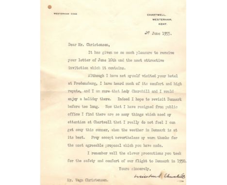
CHURCHILL WINSTON S.: (1874-1965) British Prime Minister 1940-45, 1951-55. Nobel Prize winner for Literature 1953. A good T.L.S., Winston S. Churchill, with holograph subscription, one page, 4to, 10 Downing Street, Whitehall, 18th December 1953, to Vagn Christensen of Scandinavian Airlines System Ltd, on the printed stationery of the Prime Minister. Churchill thanks his correspondent for the kindness and hospitality he and his Company extended to Churchill's wife and daughter on their visit to Stockholm, remarking 'They have both told me of the comfort in which they travelled and of the very considerate way in which you made all the arrangements'. Churchill concludes by asking 'Would you please convey to all those concerned my warm thanks and good wishes?'. Laid down to a folio page removed from a scrapbook and with a Danish newspaper clipping affixed to the lower right corner of the letter. Some light wrinkling and staining caused by the mounting. Together with a second T.L.S., Winston S. Churchill, (small stain slightly affecting two letters of the signature), one page, 4to, Chartwell, Westerham, Kent, 29th June 1955, to Vagn Christensen. Churchill thanks his correspondent for their letter and 'the most attractive invitation' and continues to state 'Although I have not myself visited your hotel at Fredensborg, I have heard much of its comfort and high repute, and I am sure that Lady Churchill and I would enjoy a holiday there. Indeed I hope to revisit Denmark before too long', further adding 'Now that I have resigned from public office I find there are so many things which need my attention at Chartwell that I really do not feel I can get away this summer, when the weather in Denmark is at its best'. Churchill concludes 'I remember well the clever precautions you took for the safety and comfort of our flight to Denmark in 1950'. Lightly laid down to a folio page removed from a scrapbook and with some very minor, light staining. Also including Clementine S. Churchill (1885-1977, Wife of Churchill) T.L.S., Clementine S. Churchill, one page, 4to, Hyde Park Gate, London, 19th September 1950, to Vagn Christensen. Churchill thanks her correspondent for his kindness in sending a book 'full of such interesting and beautiful photographs of Denmark' and further adds that she is looking forward to her visit to Copenhagen. The upper half of the letter is neatly laid down to a folio page removed from a scrapbook, and the page further features a T.L.S. by Lettice Marston, Winston Churchill's secretary, one page, 8vo, Hyde Park Gate, London, 7th September 1950, to Vagn Christensen, confirming a telephone conversation and stating that Churchill will be pleased to meet Christensen at Chartwell on 11th September 'to discuss the question of his journey to and from Copenhagen next month' and also sending a copy of the route to Chartwell from London. Neatly laid down to the folio page, slightly obscuring the upper left corner of Clementine Churchill's letter, and with the copy of the route also laid down alongside, the printed 8vo sheet featuring a map of the roads close to Chartwell Manor and Westerham to the recto and various printed directions for driving from London to the verso. Further including a second, brief T.L.S., Clementine S. Churchill, by Churchill's wife, one page, 4to, Chartwell, Westerham, Kent, 31st December 1955, to Vagn Christensen, stating, in part, 'How kind of you to remember me and to again send the delicious Norwegian bread'. Lightly laid down to a folio page removed from a scrapbook. The lot also includes three further folio pages removed from the same scrapbook, each bearing various news clippings (all in Danish and relating to Winston and Clementine Churchill), photographs and other printed ephemera relating to the Churchill's and their travels, including a printed itinerary and press release issued by Scandinavian Airlines System upon the visit of Churchill to Copenhagen in 1950. The versos of the pages featuring the signed letters also feature various pieces of printed ephemera etc. relating to Churchill including an unsigned printed 8vo stiff folding Christmas greetings card from Winston and Clementine Churchill and with a colour illustration of Churchill's painting The Messenger to the front cover. A small, interesting archive of letters and other material relating to Churchill. Some light overall age wear, generally G, 9Vagn Christensen (1913-1997) Danish Pilot who served with the RAF flying spitfires during World War II. In May 1945, he worked as a liaison officer between the British forces and the Danish government. Following the war Christensen served as Managing Director of Scandinavian Airlines System (SAS) from 1948-78. The present letters are of interest for several reasons - Churchill's letter of December 1953 is written just over a week after the Nobel Banquet at the City Hall in Stockholm on 10th December and relates to his wife's flight to Sweden in order to accept the Nobel Prize for Literature on behalf of her husband. The Banquet speech, delivered by Clementine Churchill for her husband, opened 'The Nobel Prize in Literature is an honour for me alike unique and unexpected and I grieve that my duties have not allowed me to receive it myself here in Stockholm from the hands of His Majesty your beloved and justly respected Sovereign. I am grateful that I am allowed to confide this task to my wife….' Winston Churchill visited Copenhagen in Denmark in 1950 and received an Honorary Degree (PhD) from the University of Copenhagen. During the visit, he also made a tour of the Carlsberg brewery and in Churchill's honour they unveiled their Special Brew (originally named V-beer) following the Danish tradition of producing a new beer to celebrate outstanding events such as a Royal occasion or European Coronation. Churchill's favourite drink was cognac, so in brewing him a commemorative beer, the brewers at Carlsberg created a stronger lager with cognac flavours. With an Alcohol by Volume of 9%, Special Brew was launched throughout Denmark at Christmas 1952 and has been available in the United Kingdom since the 1970s.
Railway Clearing House OFFICIAL RAILWAY MAP of London & its Environs dated 1907. Linen-backed, inside hard covers with gilt lettering, opens out to 51" x 41" (130cm x 104cm). The RCH produced the most definitive UK railway maps from 1871 onwards and this London issue in full colour shows all the main-line and Underground railways. In well-used but very reasonable condition. Small damp stains on map, tape repairs to cover. [1]
1909 London Underground POCKET MAP 'What to See and How to See it, The Excursionists' Guide with Map'. This is the map with numbers referring to points of interest listed on the reverse. Note that this is a genuine pocket-map, folded accordingly, NOT one of the ex-guidebook examples. A few creases but generally in very good condition. [1]
Southdown Motor Services (in association with the Southern Railway) Official BUS TIMETABLE dated 9 April 1936. A 308pp small booklet complete with fold-out route map and very attractive cover illustrations. A little ageing to the cover and minor damage to the spine but overall a very good copy. [1]
First-year Harry Beck London Underground DIAGRAMMATIC CARD MAP. The undated edition with no print-code, issued c. August 1933. Refers to re-naming of Dover St station to Green Park and the merger of Holborn and British Museum stations. Very light wear to covers but an excellent example, crisp and firm. [1]
London General Omnibus Company POCKET MAPS dated September 1916 (titled 'Map of some Motor-bus Extensions of the London Underground Railways') and No 12 1922 overprinted 'By the Courtesy of Electric Railway House. Presented with Herts Advertiser Time Table January 1923'. Both have a few very small fold-partings but are generally in very good condition. [2]
London Underground linen-card POCKET MAP from the Stingemore-designed series of 1925-32. This is the c1931 issue with a red cover and in the larger size of the later editions. It shows the Piccadilly Line extensions to Cockfosters, Northfields and Sudbury Town as under construction. In excellent condition, just very lightly used. [1]
1933 first edition of the Harry Beck London Underground POCKET DIAGRAMMATIC MAP with the famous cover slogan 'A new design for an old map'. This is the less-common paper version and a special issue which has been over-printed on the map-side with 'Ministry of Health Sports Ground' at Eastcote Station. A very good copy in excellent condition, very lightly used. [1]
1924 British Empire Exhibition at Wembley items comprising the official fold-out PLAN & MAP designed by Kennedy North in a style similar to MacDonald Gill with an Underground map with calligraphed station names and elaborate, colourful illustrations plus the Underground Group fold-out LEAFLET 'The Way to the Exhibition' including a plan with rail and bus stations shown. Both in lightly-used but good condition. [2]
c1908 London Underground MAP, a single-sided issue probably produced for the Peter Robinson store, their name being over-printed by Oxford Circus station. This is the first map to use the then new UndergrounD logo as a heading. It shows the Franco-British Exhibition at Wood Line and connections with LUT trams at Shepherds Bush and MET trams at Finsbury Park and Highgate. 14" x 11" (36cm x 28cm) opened. Lightly used with small fold-partings but generally good. [1]
London General Omnibus Company 1913 BEDFORD MOTOR-BUS TIME TABLE of in-Town and out-Town Services. A fold-out leaflet with a map of the two networks on either side. Print-coded September 1913, from the period when the LGOC operated services in its own name in Bedford. An extraordinary survivor, in very good condition. [1]
London Transport LEAFLETS (map diagrams) for bus drivers during WW2 (1942) re: parking of last buses returning to garages. Buses were parked in nearby streets to reduce losses from bombing raids. These are for Barking, Croydon, Dalston, Elmers End, Enfield, Holloway, Putney, Putney Heath, Seven Kings, Shepherds Bush, Sutton, Tottenham, Turnham Green, Twickenham, Upton Park, Victoria, West Green and Willesden garages. Scarce survivors mostly in excellent condition. [25]
1930s Southern National POSTER ROUTE MAP of bus services in the North Devon & North Cornwall Area. A superb poster with illustrations of Bristol G & H type buses and crests of all the counties & major towns around the edge. Undated but estimated mid-late 1930s from bus types. Measures 30" x 20" (76cm x 51cm) and is in very good condition. Has been folded. [1]
-
109182 item(s)/page