We found 109198 price guide item(s) matching your search
There are 109198 lots that match your search criteria. Subscribe now to get instant access to the full price guide service.
Click here to subscribe- List
- Grid
-
109198 item(s)/page


Lot 860
Medallions, AR: National Maritime Museum, Mercator map, 1589, 69mm, Selby Abbey, Royal Visit, 1969, 38mm and EII Bicentennial Visit, 1969, 50mm and AR & gilt pairs: Gibraltar, New Constitution, 1969, 38mm and Duke of Edinburgh, Commonwealth Games, 1970, 39mm, first, as struck, otherwise all proofs, FDC, all cased (7)

Lot 3129
WHEATLEY, Henry B. (editor). The Diary of Samuel Pepys. London: 1893-1899. 10 vols. including Pepysiana and index vols., 8vo (217 x 135mm.) Frontispieces, titles printed in red and black, plates, illustrations, a folding plan and a folding map, publisher's advertisements bound at rear of vol. 8. (Some light spotting or browning.) Original blue cloth, the spines blocked in gilt, t.e.g. (extremities bumped). - And three volumes of related interest (13).
Lot 3146
TOPOGRAPHY. - John ASHTON. The Fleet, its River, Prison, and Marriages. London: 1888. 8vo (223 x 137mm.) Folding wood-engraved frontispiece, folding map at rear, numerous illustrations. (Spotted.) Original cloth, t.e.g. (extremities bumped, spine faded). - And forty-six others, the majority of topographical interest (47).
Lot 3165
BIBLE, in English. - The Holy Bible, containing the Olde Testament and the New. London: Bonham Norton and John Bill, 1619. [bound with:] The Booke of Common Prayer. London: 1619; The Genealogies… by I.S. [N.p: n.d.]; The Whole Book of Psalmes. London: 1620. 8vo (166 x 110mm.) Lined in red throughout, 1 double-page map of the Holy Land, 1 full-page woodcut of Adam and Eve, numerous woodcut decorations. (Map shaved into the image area, occasional soiling.) Contemporary red satin binding, embroidered with an overall design worked in silver thread and coloured silks, the upper cover with a central roundel containing a stylized carnation, the surrounding design of scrolling foliage worked in silver with small polychrome buds and flower heads, the flat spine divided by worked thread into five compartments, each containing a polychrome flower spray, g.e. gauffered and painted in red with a stylized floral design (rubbed, hinges splitting, small areas of damage to embroidery, small areas of silver thread lacking or damaged, ?lacking preliminary blank). Provenance: Mary Cooke (signature to front free endpaper). Herbert 368.
![H.M.S.O. (publishers). An Inventory of the Historical Monuments in the City of Cambridge. [London:] 1959. 3 vols., including](http://lot-images.atgmedia.com/SR/10123/2772179/3172-80-10123_468x382.jpg)
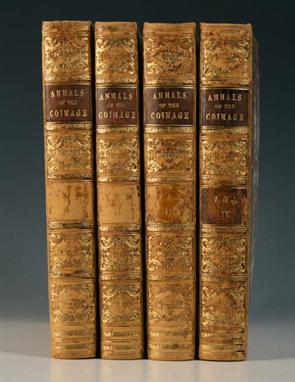
Lot 3181
RUDING, Rogers. Annals of the Coinage of Britain and its Dependencies. London: 1817. 4 vols., 4to (268 x 207mm.) Engraved folding map, plan, 115 engraved plates (5 bound in Appendix). (Occasional light spotting or browning.) Near contemporary half-calf, the spines in six compartments with raised bands, morocco lettering pieces to the second and fourth, the others with repeat decoration in gilt (extremities rubbed and scuffed, vols. I, II & III each lacking a morocco onlay). Provenance: Sir Richard Temple (armorial bookplates). Lowndes S2149.


Lot 3208
STANLEY, Henry M. In Darkest Africa or the Quest Rescue and Retreat of Emin Governor of Equatoria. London: 1890. 2 vols., 8vo (220 x 135mm.) Plates and illustrations, 1 folding map. (Occasional spotting.) Original decorated cloth (head and foot of spine slightly bumped). Provenance: Chippens Bank (ink stamps to endpapers and title-page).

Lot 3209
STANLEY, Henry M. How I found Livingstone. Travels, Adventures, and Discoveries in Central Africa… second edition. London: 1872. 8vo (219 x 134mm.) Albumen-print portrait frontispiece, 5 maps (4 folding), numerous plates and illustrations. (Map torn and repaired with adhesive tape, occasional other tears, without loss.) Original cloth (rebacked, old spine laid down).


Lot 3253
NICOLAS, Nicholas Harris. The History of the Battle of Agincourt. London: 1827. Limited 'Letter press' edition of 250 copies, 8vo (193 x 110mm.) Hand-coloured frontispiece, engraved additional title, title printed in red and black, 1 folding engraved map. (Occasional spotting or browning.) Late 19th century blue morocco, by H. Sotheran & Co., the spine in six compartments with raised bands lettered in gilt to the second and third, gilt turn-ins, t.e.g. Provenance: Stanley Leonard Barry (armorial bookplate and occasional annotations).
Lot 3273
WILLIS, Browne. The History and Antiquities of… Buckingham. London: 1755. 4to (255 x 195mm.) (Lacking map and index, first few leaves damp-stained, occasional spotting.) Old calf (worn, extremities scuffed, spine lacking.) Provenance: F. Simpson (signature to title-page); Stanley Leonard Barry (armorial bookplate and occasional annotations).

Lot 3334
TOLKIEN, J.R.R. The Return of the King being the Third Part of the Lord of the Rings. London: George Allen & Unwin Ltd., 1955. First edition, 8vo (220 x 137mm.) Folding map printed in red and black at rear. Original cloth (extremities bumped), dust-jacket (minor nicks, spine damp-stained and darkened).
![[Maps]. Thirty-one Michelin 1/200,000 scale folding road maps of France, late 1940s (including three linen- backed); a touris](http://lot-images.atgmedia.com/SR/10054/2770934/369-64-10054_468x382.jpg)
Lot 369
[Maps]. Thirty-one Michelin 1/200,000 scale folding road maps of France, late 1940s (including three linen- backed); a tourist map of France, 1938; a street-plan of Paris, 1953; approximately thirty assorted folding road maps and street plans, mainly of Swiss, Italian and Austrian interest, most late 1940s; a folding map of Europe, 1938; and another map. Visit www.dnfa.com for condition reports.
![A boxwood surveyor's folding ruler by F.H. & C. Elliott, of 56 Strand, [London], with integral compass and spirit level, 30.](http://lot-images.atgmedia.com/SR/10054/2770934/410-64-10054_468x382.jpg)
Lot 410
A boxwood surveyor's folding ruler by F.H. & C. Elliott, of 56 Strand, [London], with integral compass and spirit level, 30.5 cm long (extended); a map mile-o-meter; and an ebony desk ruler; contained in a (unrelated) small single-draw chest with a sunken lead-lined top. Visit www.dnfa.com for condition reports.

Lot 459
Kelly's Directory of Somersetshire 1894. Crimson cloth gilt, quarto (map torn, with loss); Jenkins, J.G. The English Farm Wagon, third edition, David & Charles, Newton Abbot 1981. Boards, dustjacket, illustrations, octavo; twelve assorted other works of West Country interest; and twenty-six titles from the 'Britain in Pictures' series, (40). Visit www.dnfa.com for condition reports.
![[Buckingham, James Silk]. A Summer Trip to Weymouth and Dorchester, including an excursion to Portland, and a visit to Maide](http://lot-images.atgmedia.com/SR/10054/2770934/460-64-10054_468x382.jpg)
Lot 460
[Buckingham, James Silk]. A Summer Trip to Weymouth and Dorchester, including an excursion to Portland, and a visit to Maiden Castle, the Amphitheatre, and other places of interest, Benson & Barling, Weymouth 1849. Later quarter calf, folding map frontispiece, octavo. Visit www.dnfa.com for condition reports.

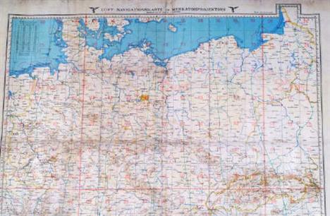
Lot 542
A Second World War German Luftwaffe Linen-backed Map, ' Luft -Navigationskarte in Merkatorprojektion', covering the United Kingdom, Ireland, and Northen Europe, dated 1941, 58cm x 73cm; A Second World War German field torch, retaining much of its original grey paint finish; A Second World War German Mauser rifle cleaning kit, with oil and pull through brush etc; a pair of Zeiss, Dienstglas 6 x 30 field glasses, ser. no. 1920262; a souvenier of Gummersbach, German soldier's head with helmet, profile and plaque mounted on a polished marble base,12cm x 8cm; nine long playing vinyl records mainly of Hitlers speeches during the early 1930's, (lot). Visit www.dnfa.com for condition reports.

Lot 78
Poster 'Explore The North Yorkshire Coast By Train' by Lander. Q/R size in typical Lander style with map backdrop and images of various places to see and things to do such as Golf, Tennis, Bathing etc. Published by British Railways North Eastern Region and printed by Stafford Ltd., Netherton, Nottingham. Some folds but excellent condition throughout.

Lot 203
SER Timetables 1853 bound Book measuring just 5½" x 3½" and a thick 1½". In exceptionally good condition, the only minor defect being the first fold-out map on page 2 has been taped back at some point and there is a small rub at the top of the spine. There are 12 monthly timetables within the volume, the first commencing January 1853 the last December 1853. An astonishing survivor.
Lot 209
Great Western Railway linen Plan on original wooden roller, 'Shepton Mallet Water Supply'. A lovely, hand coloured map bearing the GWR Swindon Stamp dated 17th March 1934. Plan shows the GWR station and lines from Witham and Yatton. Excellent condition and really a little gem. Comes with a couple of office copies of Bromsgrove South Signal Box and Standish Junction Signal Box.
Lot 454
Maps & Booklets, a wonderful selection from both North and South of the Border. Here are 9 Scottish Maps to include Tramway System of Glasgow; ram Routes of Glasgow; Street Transport of Glasgow; Bacons Perthshire; Bacons Glasgow; BR West Highland Railway colour brochure and Bonnie Scotland. This side of the Border are Southern Railway Southampton Docks; GWR Map in wallet; LSWR General System; Mile By Mile etc. Must be viewed to be appreciated.
Lot 491
GWR Leather Case containing a delve of official Railways paperwork, to include Midland Railway Loco Firing Instructions, Southern Railway Drivers Instruction Book, 2 x GWR General Appendixes to the Rule Book Aug 1st 1936, a hardback book Locomotive engine driving by Michael Reynolds 1898, Fold out map of the LNER, GWR Look Out official, GWR Winter resorts Sept 1933, GWR Train Signalling regulations 1936, GWR Telephone message codes 1939 and various others, well worth viewing.


Lot 725
Pinkerton (Robert E.). Hudson’s Bay Company, 1st ed., New York, 1931, b & w illusts. from photos, orig. cloth in frayed and torn d.j. (portion of spine missing), together with Simpson (Commander C.J.W.), North Ice. The British North Greenland Expedition, 1st ed., 1957, col. and b & w illusts. from photos, map endpapers, orig. cloth in frayed and torn d.j., both 8vo, with other miscellaneous travel (3 shelves)
Lot 761
Roskill (Captain S.W.). The War at Sea, 1909-1945, 3 vols. in 4, mixed eds., 1954-1961, vol. 1 signed on title by the author, b & w illusts. from photos, num. folding maps and plans, orig. cloth in sl. soiled and frayed d.j.s, large 8vo, together with Atteridge (A. Hilliard), History of the 17th (Northern) Division, 1st ed., Glasgow, 1929, sketch maps to text, folding map at rear, orig. cloth gilt, rubbed and faded on spine, plus Bryant (Arthur), Triumph in the West, 1943-1946. Based on the Diaries and Autobiographical Notes of Field Marshall the Viscount Alanbrooke, 1st ed., 1959, inscribed on title ‘To Gowlland with best wishes & deep gratitude from Alanbrooke F.M. 21.10.59’, port. frontis., num. maps, orig. cloth in d.j., and others, mostly naval interest, several author inscribed. From the library of Commander Geoffrey Gowlland, many volumes containing his bookplate and manuscript notes. (3 shelves)
Lot 1
Adam (Alexander). A Summary of Geography and History both Ancient and Modern, 5th ed., 1816, fourteen b & w eng. maps, mostly folding, some off-setting, book plate of Cosmo Little on front paste down, joints weak, strengthened with masking tape, contemp. calf, contrasting morocco label to spine, slight fraying to foot of spine, 8vo, together with Hughes (Wiiliam, ed.) Phillips’ Comprehensive School Atlas of Ancient and Modern Geography, 1867, eng. frontis. ‘comparison’ plt. of the world’s rivers and mountains, forty col. printed maps (complete as list), map of the world split along old folds, several maps with closed marginal tears and slight splitting to central fold, occ. spotting and soiling, contemp. half morocco, upper board detached, heavily rubbed and frayed, lg. 8vo, with Butler (Samuel), An Atlas of Ancient Geography, 1827, calligraphic title, twenty eng. maps with orig. hand col. & one b & w plt. of ancient town plans, occ. splitting to central folds, some water staining, slight off setting and soiling, near contemp. ink and pencil ownership incsriptions to pastedown and prelims., contemp. half morocco, with paper label to upper board, boards near detached, spine partially lacking, heavily rubbed and frayed, 8vo, together with another four similar. Sold as a collection of maps, not subject to return. (7)

Lot 2
Anson ((George)). A Voyage Round the World, in the years MDCCXL, I, II, III,IV, by George Anson, Esq; afterwards Lord Anson, Commander in Chief of a Squadron of His Majesty's Ships, sent upon an Expedition to a South-Seas. Compiled from his papers and materials by Richard Walter, 15th ed., 1776, folding eng. map frontis., forty-two eng. plts. and charts, etc., including many folding, some plates a little creased and with occn. minor fraying to fore-edges, generally not affecting plates, contemp. calf, modern antique-style reback, outer corners bumped or showing, 4to nw (1) Plate missing - Chart of the Pacific.
![Beattie (William). The Danube, its History, Scenery and Topography, pub. Virtue, [1844], addn. eng. vign. title, eng. port.](http://lot-images.atgmedia.com/SR/10729/2764436/5-101-10729_468x382.jpg)
Lot 5
Beattie (William). The Danube, its History, Scenery and Topography, pub. Virtue, [1844], addn. eng. vign. title, eng. port. frontis., seventy-eight steel eng. plts. by W.H. Bartlett, two single-page maps, wood eng. illusts. to text, contemp. half calf, boards detached, spine worn with loss, 4to, together with Pardoe (Julia), The Beauties of the Bosphorus, Virtue, n.d. c. 1840s, addn. eng. title, eighty-one steel eng. plts., two eng. ports., single-page map, contemp. half calf, worn to extrems., spine ends frayed, 4to (2)
Lot 12
Cave (Henry W.). Golden Tips. A description of Ceylon and its great tea industry, 1st ed., 1900, numerous b&w plts. and illusts. after photos, folding map, etc., a.e.g., orig. profusely gilt-dec. white cloth, spine lightly dulled, 2 mm closed tear to head of spine, 8vo, together with Bartlett (W. H.), Forty Days in the Desert, on the track of the Israelites; or, A Journey from Cairo, by Wady Feiran, to Mount Sinai and Petra, n.d., c. 1840s, eng. frontis., vign. title, map, and twenty-five b&w steel eng. vign. views, tissue-guards to each, orig. gilt-dec. cloth, a little rubbed and some marks, spine somewhat sunned with a little fraying to extreme head and foot, large 8vo, plus Ellis (Robert), A Treatise on Hannibal’s Passage of the Alps, in which his route is traced over the Little Mont Cenis, Cambridge, 1853, folding eng. map frontis. and five eng. maps and plans, including several folding, each hand- coloured in outline, pubs. ads. to endpapers, upper inner hinge cracked, orig. cloth, a little rubbed, 8vo, and three others (Christopher Wordsworth, Athens and Attica: Notes of A Tour, 3rd ed., revised, 1855 & A. C. Inchbold, Under a Syrian Sun, 2 vols., 1906), all 8vo (6)
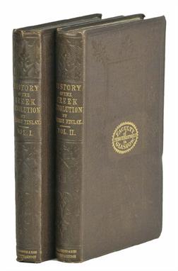
Lot 20
Finlay (George). History of the Greek Revolution, 2 vols., 1st ed., Edinburgh, 1861, folding coloured map to first vol., bookseller’s ticket of Maclehose, Glasgow, to front pastedown of each vol., binder’s ticket of Edmonds & Remnants, London, to rear pastedown of first vol., orig. blindstamped brown cloth gilt, with gilt oval stamp of the Faculty of Procurators in Glasgow to centre of upper cover of each vol., 8vo. Hopkirk 532. Fine copy. (2)
Lot 22
Goodisson (William). A Historical and Topographical Essay Upon the Islands of Corfu, Leucadia, Cephalonia, Ithaca, and Zante: with Remarks Upon the Characters, Manners, and Customs of the Ionian Greeks..., 1st ed., 1822, four litho maps & eight litho plts. (inc. map frontis.), errata leaf at rear, occ. minor spotting, edges untrimmed, orig. boards, joints cracked and some wear to extrems., 8vo. The author spent more than five years in the Islands as a medical officer with the British Army. Blackmer 705. (1)

Lot 25
Holland (Henry). Travels in the Ionian Isles, Albania, Thessaly, Macedonia, &c. during the years 1812 and 1813, 1st ed., 1815, single-page eng. map, frontis., twelve eng. plts. after drawings by the author, occn. light toning, oval library stamp to upper outer corner of title and front pastedown (both cancelled), later presentation inscription to front endpaper (repaired with clear tape to verso), det. along upper inner hinge, contemp. calf, rubbed and some wear to outer corners, modern reback, 4to. Blackmer 825. Atabey 589. (1)
Lot 32
Leake (William Martin). Journal of a Tour in Asia Minor, with comparative remarks on the Ancient and Modern Geography of that Country, 1st ed., 1824, half-title, large folding general map, two single-page eng. maps, with some spotting and offsetting, several b&w wood eng. illusts. to text, modern antique-style qtr. calf with marbled boards, gilt morocco label to spine, 8vo. Blackmer 972. (1)
![Linton (William). The Scenery of Greece and its Islands, pub. Cassell, Petter, and Galpin, [1869], fifty views, correct as l](http://lot-images.atgmedia.com/SR/10729/2764436/34-101-10729_468x382.jpg)
Lot 34
Linton (William). The Scenery of Greece and its Islands, pub. Cassell, Petter, and Galpin, [1869], fifty views, correct as list, 8pp. pubs. cat. at rear, without the map (as often in this edition), a few plts. with some light foxing, a.e.g., orig. gilt-dec. red cloth, very sl. rubbed to extrems., and covers a little darkened to edges, 4to (1)
Lot 37
Martineau (M.A.). Nouvel Atlas Illustre Geographie Universelle Comprenant La Geographie, L’Histoire, L’ Administration, La Statistique, Etc., Paris, 1895, title page printed in red & black, sixty-four double page hand col. maps each with a b & w eng. vignette (complete as list), together with an un-called for large col. printed folding map of the European railway network by A.T.Chartier tipped in at rear, hinges weak, contemp. qtr. morocco gilt, dec. gilt upper board, rubbed and frayed at extrems., folio, together with Bouillet (N.), Atlas Universel D’Histoire et de Geographie, 3rd ed., Paris 1877, twelve chromolitho. double page plts. of heraldic crests and flags & eighty- eight maps, mostly double page, many with orig. outline col., hinges weak, contemp. qtr. morocco gilt, spine split, rubbed and frayed at extrems, thick 8vo., with Domergue (Eugene), Geographie Pittoresque des Cinq Parties du Monde, 2 vols. (of 4), Paris, n.d., c.1880, title pages with ink library stamps, wood eng. hemispheral world map with orig. hand col., numerous b & w wood eng. plts. and illusts. to text, near contemp. qtr. red morocco gilt, slight rubbing at extrems., 4to (4)

Lot 45
Pashley (Robert). Travels in Crete, 2 vols., 1st ed., Cambridge & London, 1837, half-titles present, errata/addenda leaf at rear of vol. 2, ten uncol. litho. plts., several b&w wood engs. to text, folding plate, with inscriptions, large folding b&w litho. map of Crete at rear of second vol., printed label of Mansfield Subscription Library to front pastedown of first vol. (otherwise without library marks), orig. cloth gilt, recased with orig. spines laid down, somewhat faded to spines and edges, 8vo. Blackmer 1263. A key work on Crete. Pashley spent most of 1834 on the island accompanied by Antonio Shranz who drew the illustrations. (2)
Lot 48
Pouqueville (Francois Charles Hugues Laurent). Travels through the Morea, Albania, and Several Other Parts of the Ottoman Empire to Constantinople, during the Years 1798, 1799, 1800, and 1801 ..., 1st English ed., printed for Richard Phillips, 1806, folding eng. plan of the Plain of Tripolitza (waterstained), folding printed table, and folding aquatint view of the Castle of the Seven Towers and Constantinople, with yellow wash, close-trimmed to leading margin, single plate of costume (some light waterstaining), together with Travels in Epirus, Albania, Macedonia, and Thessaly, 1st English ed., printed for Sir Richard Phillips, 1820, eng. port. frontis of Ali Pacha, three uncol. aqua plates of costume, occn. minor marginal foxing, plus Travels in Southern Epirus, Acarnania, Aetolia, Attica, and Peloponesus, or the Morea, &c. in the Years 1814-1816, 1st English ed., printed for Sir Richard Philips, 1822, folding b&w eng. map frontis., single-page eng. map of Ianina, single b&w aqua plate of costume, partly untrimmed, all uniformly bound in modern half red morocco gilt, 8vo (3)
Lot 49
Priestley (Raymond E.). Antarctic Adventure. Scott’s Northern Party, 1st ed., 1914, b & w illusts. from photos, folding map at rear, some minor scattered spotting, t.e.g., orig. blue cloth, lettered and blocked in silver, poorly rebacked, preserving orig. spine (new endpapers), 8vo. Spence p. 41. (1)
Lot 52
Schliemann (Dr. Henry). Troja: Results of the Latest Researches and Discoveries on the Site of Homer’s Troy, and in the Heroic Tumuli and Other Sites, Made in the Year 1882; and a Narrative of a Journey in the Troad in 1881, 1st English ed., 1884, coloured map frontispiece (detached), three folding maps and plans at end, one detaching, illustrations, front stiching weak, bookplate, original cloth gilt, joints splitting, wear at spine ends, rubbed, t.e.g., 8vo (1)


Lot 60
Weld (Isaac, junior). Travels through the States of North America, and the Provinces of Upper and Lower Canads, during the Years 1795, 1796, and 1797, 1st ed., pub. John Stockdale, 1799, eng. frontis., folding eng. map hand -col. to outline, fourteen eng. plts. and plans (complete), ink stain to verso of leaf 2R2, occ. minor spotting to few leaves, inner hinges repaired, contemp. calf, recent reback with gilt dec. spine and green morocco title label (spine leather faded), corners repaired, 4to. Sabin 102541 and Howes W235. (1)
-
109198 item(s)/page