We found 109198 price guide item(s) matching your search
There are 109198 lots that match your search criteria. Subscribe now to get instant access to the full price guide service.
Click here to subscribe- List
- Grid
-
109198 item(s)/page


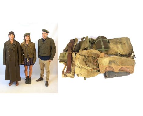


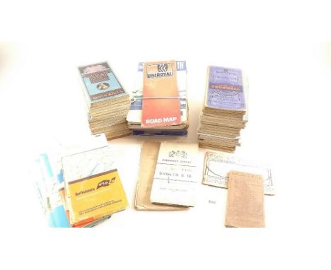
Lot 184
London and South Western Railway Boardroom map and prints, this important piece was purchased from Clapham Railway museum and was believed to have hung in the LSWR boardroom at Waterloo, The carved and Gilded frame measures 50 inches x 38 inches and has its original glass, displays a central map of the LSWR system surrounded by views of Trevone Padstow, Boscastle, Tintagel, Bude, Lydford Gorge, Chagford Glen, Budleigh Salterton, Fingle Bridge, Torrington and Lyme Regis. Makers name Photochrom Co Ltd London at the bottom a truly remarkable and historic piece.


Lot 403
John Steven Dews, British b.1941- "Velsheda off the Needles"; colour reproduction print, signed in pencil, bears blindstamp, 58.4x73.2cm: together with a National Geographic Map of North America, 149x115.5cm, a map of the Republic of Venezeula, printed for the bicentennial of the birth of Simon Bolivar, 91x109cm, and a National Geographic Map of the Middle East, 59.5x95.5cm, (4) CONDITION REPORT: dimensions are of sheet visible


Lot 272
Scarce Luftwaffe aces. 1979 Tunisia CDS Postmark Escape from Libya Cover depicts map of Libya, RAF Aircrew walking away from a crashed Wellington Bomber in the Libyian Desert and RAFES badge. The Libyan Government would not permit this cover to be taken to Libya, Consequently it has been processed in Tunisia and conveyed close in the Libyan border. Special Signed Col D.E.Neumann JG27 Messerschmitt Fight Pilot Battle of Britain about 50 missions over England 13 victories. and Werner Schroer. with Swords 114 victories. Died 1985 Luftwaffe Pilots Details and 2 B/W photo's enclosed. Certified copy of 258 Good condition. Est £5 - 10

Lot 273
Air Marshal Sir Rochford Hughes 1979 Tunisia CDS Postmark Escape from Libya Cover depicts map of Libya, RAF Aircrew walking away from a crashed Wellington Bomber in the Libyian Desert and RAFES badge. The Libyan Government would not permit this cover to be taken to Libya, Consequently it has been processed in Tunisia and conveyed close in the Libyan border. Signed by Air Marshal Sir Rochford Hughes KCB, CBE, AFC. Good condition. Est £5 - 10


Lot 181
After John Ogilby, "The Continuation of the Extended Road from Oakeham to Richmond" in two plates, 48 x 49cm and 36 x 45cm; also Barnstable to Truro, London to Barwick, a map of Cornwall by Robert Morden, 36 x 43cm and "An Accurate Map of the East Indies", 30 x 21cm, all hand coloured, all foxed and stained.


Lot 1912
Aikin-J, "A description of the Country from 30 to 40 miles around Manchester" Complete with the map of around Manchester and map of Manchester and Salford, printed for John Stockdale, Piccadilly, London June 4th 1795, bound in half tan calf with blackboards and gilt lettering, Taylor-Henry, Old Halls in Lancashire and Cheshire published by JE Cornish, 16 St Anne's Square, Manchester 1884. (2)


Lot 2301
Ten assorted pictures, including a print of Warwickshire 1786, Tom Kitchen; together with a hand tinted map of Hereford by Thomas Conder; maps of Wiltshire, Middlesex and Dorset and others, original Paul Nicholas watercolours, including Chaffinches and Primroses, a Tawny Owl and Mandarins and a David Shepherd limited edition print, number 1448 of 1500 with proof (10)


Lot 114
Thomas Bowen (D.1790), Road Map London to Shrewsbury and Welshpool in Montgomery, together with a 19th century map of Shropshire, published by Henry Teesdale and co, 302 Holburn, engraving with later hand colouring and a 19th century map of Shropshire drawn and engraved for Cobbett's Geographical Dictionary of England and Wales (3)


-
109198 item(s)/page