A COLLECTION OF SECOND WORLD WAR EPHEMERA, associated to Captain P. A. Boys of the Army Photographic Interpretation Unit, comprising Type D binocular photographic viewers and other viewing equipment, a leather portfolio filled with instructional guides to aerial photograph interpretation including personal notes, an Interpreter's Reference Dossier, aerial and non-aerial photographs, a fully annotated and interpreted map of Dunkirk, a hard back copy of Air Navigation part II, papers specific to Captain Boys, a pair of army issue leather boots and jodhpurs (qty) (Est. plus 18% premium inc. VAT)
We found 108737 price guide item(s) matching your search
There are 108737 lots that match your search criteria. Subscribe now to get instant access to the full price guide service.
Click here to subscribe- List
- Grid
-
108737 item(s)/page
Welsh interest volumes "The Principal Rivers of Wales", number 1 London 1811, number 2, together with "Y Llenor" 1932, "The Strand Coronation souvenir" 1937 booklet, "Our Own Country" volumes and "Views in Wales", together with large Campion's map of collieries, Ironworks, Railways and Stations in the mineral district of South Wales 1884. (2) (B.P. 24% incl. VAT)
BRAYLEY (E.W.) A Topographical History of Surrey. (2nd edition) revised & edited by Edward Walford, 4 vols. pictorial engraved & printed titles, num. steel-engraved plates. text illus., 3 coloured maps & a d-page illustrated map of the River Mole; near contemp. half calf & cloth, gilt-panelled spines, 4to. (1878).
COBBETT (W.) Rural Rides . . . including many rides and tours never before reprinted, edited with an introduction, notes (etc.) by G.D.H. and Margaret Cole. Limited Edition, 3 vols. e/ps. map, num. text vignette illus. (by John Nash); cloth-backed marbled boards, partly unopened. 1930. * the favoured modern edition; 1,000 numbered sets were issued, this one out-of-series.
WRIGHT (A.), editor. Twentieth Century Impressions of Ceylon: its history, people, commerce, industries, and resources. First Edition. decorated title, a map, very many photo. & other illus. (some full-page), erratum note (p. 305); publisher's gilt red morocco (defective), impl. 8vo. 1907. * an exhaustive account, more than 900pp. printed in triple column.
KNOX (Robert) An Historical Relation of the Island Ceylon, in the East-Indies: together, with an account of detaining in captivity the author and divers other Englishmen . . . and of author's miraculous escape. First Edition. folded map & 8 copper-engraved plates (only, of 15), advert leaf; old calf, 4to. 1681.
ARMY MAP SERVICE (USA.) - A.A.F. Cloth Map Asiatic Series Nos. 32 & 33; colour printed back to back on silk sheet. Washington, 1944 * No. 32 - French Indo China; No. 33 - Central China, the famous 'Flying Tigers' survival map; together with A.F.F. Cloth Chart, No. 133, K'un-Ming, Yunnan etc.; colour printed back to back on silk sheet. Washington, 1944 * Office of Strategic Services (wartime Intelligence agency of US.) coordinating espionage activities behind enemy lines.
DESERT STORM - 3 Printed & Declassified Operational Maps for the concluding combat days (Feb 25th, 26th & 27th, 1991) of the Coalition Forces response to Iraq's invasion of Kuwait; this ground offensive (Desert Sabre) commenced 24th Feb, with the invasion of Iraq. * the three mounted & framed maps (63 x 90cms.) headed 'FWD FMA PIC SITREP', show symbols of operational units (infantry, armoured units, etc.), symbols for operational strength (brigade, division, etc.), demarcations of allied enemy forces together with relevant keys & the external / internal distribution list; all overlay a topographical map of the area. 'Printed by 14IndepTopoSqnRE (Gulf), 02/91 . . . ' a fascinating & mostly unseen depiction of this modern conflict.
CHINA - Stanford (Edw.) Atlas of the Chinese Empire . . . 23pp. of coloured maps (1 d-page); gilt-cloth, 4to., The China Inland Mission, (1908); sold with Stanford's Map of China, folded into cloth covers, (ca. 1900); and Arrowsmith's Map of the Asiatic Archipelago, folded into cloth covers, (new edition, 1876); also a pre-war Chinese photo. album.
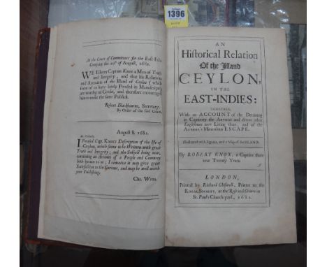
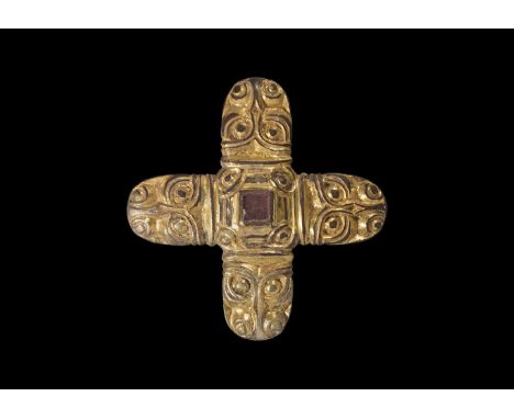
Later 6th-7th century AD. A silver sword mount formed as a central square panel with cell above, four beast-head arms; the cell with inset garnet cloison and crimped gold foil behind; the centre hollow with slider-bar to the reverse; each arm a stylised beast-head with bilinear collar, bilinear brow-ridge and nasal, pellet eyes and nostrils with bilinear frames. [A video of this lot is available on the TimeLine Auctions website] See Franceschi, G., Jorn, A. & Magnus, B. Mennesker, Guder og Masker i Nordisk Jernalderkunst, vol.1 Borgen, 2005; Hammond, B. British Artefacts vol.1 - Early Anglo-Saxon, Witham, 2009; Menghin, W. Das Schwert im Frühen Mittelalter, Stuttgart, 1983; Pollington, S., Kerr, L. & Hammond, B. Wayland's Work: Anglo-Saxon Art, Myth & Material Culture from the 4th to 7th century, Ely, 2010; Mortimer, P. Woden's Warriors. Warriors and Warfare in 6th-7th Century Northern Europe, Ely, 2011. 18 grams, 45mm (1 3/4"). Property of a European gentleman; acquired German in the late 1960s-early 1970s. Sword pyramids were once a very rare class of find, discovered only in very high-status burials such as Niederstotzingen (Germany), Sutton Hoo Mound 1 (Suffolk, England) and the Broomfield barrow (Essex, England"). Since the 1980s, a quantity of such finds have come to light and the object-class is now better understood. They are found predominantly in England, the Rhineland, central Europe and southern Scandinavia, and were a short-lived display item. The classic form is a truncated hollow gold (or silver, or bronze) pyramid with a bar to the reverse, inset garnet and glass plaques to the four faces and top (Pollington et al., fig.8.52 and plates 19 54 55; Hammond, p.73-4; Menghin, map 22"). Several variant forms do exist, such as the octagonal-base and the conical types (Hammond, 2009 item 1.4.2.2-f; Mortimer, 2011 p.117"). Another common Continental variant includes a flat-section rectangular plaque, as well as a form with curved edges to the plaque (Menghin, map 23"). The present example with four beast-heads is apparently unique, although it has parallels in later harness and other mounts. The beast-heads have close parallels on the headplate of a 6th c. silver bow-brooch from Stora Gairvide, Gotland (Franceschi et all, item 75) and on the footplate of another from a burial mound at Sandal, Norway (Franceschi et al., item 66"). The exact purpose of the pyramids is not known, but when they occur in graves they are usually placed in pairs high on the sword's scabbard (Menghin, p.150 and fig.90) which suggests that they were used in the suspension of the scabbard from its belt, or more evocatively in the fastening of textile 'peace-bands' which secured the sword in its scabbard and provided a very visible demonstration that the owner did not intend to draw it in haste (Mortimer, p.116"). Very fine condition.
Published 1561 AD. Taken from La Geografia di Claudio Tolomeo Alessandrino, Venice, translated by Girolamo Ruscelli and Vincenzo Valgrisi as 'Nuouamente tradotta di Greco in Italiano'; comprises an original double-page with Latin text relating to the map to reverses with hand-coloured folding map titled SORIA ET TERRA SANTA NVOVA TAVOLA, also showing Cyprus and part of the eastern Mediterranean region, the border, water and hills coloured with red lining to most place names. See British Museum, General Catalogue of Printed Books to 1955 pp.334-344 for information on the issues of this work. 5.93 grams, 30x22cm (12 x 8 3/4"). Ex Swiss collection; acquired 1980s. Claudius Ptolemaeus (circa 100-170AD) was born in Alexandria and became one of the foremost scholars of his day as a geographer (he is sometimes known as the 'Father of Geography) and mathematician with his works being important for centuries after his death; in the Medieval period, his atlas was first published in Bologna in 1477; an incomplete copy of the 1561 edition containing fifty (of sixty-four) maps was sold by Christies, 10 October 2013 lot 68 and achieved a hammer price of 10000. Very fine condition. Rare.
A collection of 18th century and later book maps, including two county maps of Monmouthshire, one by Joseph Ellis from his English Atlas 1765 and the other from John Owen and Emanuel Bowen's Brittanica Depicta published 1720, plus later maps, coloured prints of Abergaveny, and 'The Hub' cycling map of England & Wales by George Newnes (12)
Judith Ackland (1892-1971), an Arts & Crafts fruit bowl, decorated with pen and ink island map, and tall ships at sea 23.5 cm dia.There are scratches throughout, some minor dents, the design is crazed all over.Some staining to the inside, otherwise generally good condition, no obvious signs of significant damage or repair
John Speed (1552-1629) 'Barkshire Described' Anno 1350 map of the count of Berkshire, Performed by I. Speede and are to be solde in Popes head Alley by I. Sud and George Humble London 1627 with a prospect of Windsor Castle and a list of the original knights of the Order of the Garter, with portrait of Edward III in the top right hand quarter who both founded the order and rebuilt Windsor during his reign. This example possibly engraved by Jodocus Hondius II 51 cm x 38 cm, framed and glazed
-
108737 item(s)/page