We found 109182 price guide item(s) matching your search
There are 109182 lots that match your search criteria. Subscribe now to get instant access to the full price guide service.
Click here to subscribe- List
- Grid
-
109182 item(s)/page


Lot 144
A collection of historic information relating to the moon, including the Sky at Night 1961, photos from 1910, reference and information pamphlet belonging to W.Shackleton a canvas backed fold out detailed map of the moon, detailing names of craters and other land reference points, 'Pacific Discovery' Magazine Nov/Dec 1952 and other photos, some negatives, news paper articles etc


Lot 768
Full title: Cornelis de Bruijn (1652-1727): 'Voyages de Corneille de Bruyn par la Moscovie, en Perse...', Rouen, Charles Ferraud, 1725, 3 vol.Description:4to. Full title: Voyages de Corneille de Bruyn par la Moscovie, en Perse, et aux Indes Orientales. Gilt spines with five raised bands. Pl.: III (13 + 3 maps), IV (29 + 1 map), V (14).Condition reports and high resolution pictures are available on our website at www.coronariauctions.com. Further questions are always welcome at info@coronariauctions.comPlease note that external links are available on our website www.coronariauctions.com

Lot 772
Full title: Gerard van Loon (1683-1758): 'Aloude Hollandsche histori der keyzeren, koningen, hertogen en graven', The Hague, Pieter de Hondt, 1734, 2 vol.Description:Folio. Full title: Gerard van Loons aloude Hollandsche histori der keyzeren, koningen, hertogen en graven. Gilt spine with six raised bands. I: 10 pl., 10 maps, 4 folding pl.; II: 1 pl., 1 map and 15 folding pl.Condition reports and high resolution pictures are available on our website at www.coronariauctions.com. Further questions are always welcome at info@coronariauctions.comPlease note that external links are available on our website www.coronariauctions.com

Lot 774
Full title: Pierre van Musschenbroek (1692-1761): 'Essai de Physique', Leiden, Samuel Luchtmans, 1739, 2 vol.Description:4to. Gilt spine with five raised bands. Compl. with 29 pl. (I) and 4 pl. and 1 folding map (II).Condition reports and high resolution pictures are available on our website at www.coronariauctions.com. Further questions are always welcome at info@coronariauctions.comPlease note that external links are available on our website www.coronariauctions.com


Lot 493
Of Naval interest: two silver presentation cigarette cases, the first engraved ‘LLOYD LINDSAY | DUNKERQUE 7th JUNE 1919’, the second ‘F. G. WILIAMSOM | HMS SHANNON 1916 | GRAND FLEET CRUISERS WINNERS ERA’S GIG RACE’, a silver vesta case, engraved ‘FROM L.t. COL SIR MARK SYKES, BART. M.P. R.N. & M.T. 1913’ and a white metal cigarette case engraved with map of Europe, various dates and makers, first length 8.5cm. (4) £100-£150 --- Importation Duty This lot is subject to importation duty of 5% on the hammer price unless exported outside the UK --- --- Condition Report All with considerable wear. Gross weight of three silver examples: 123.3gm.


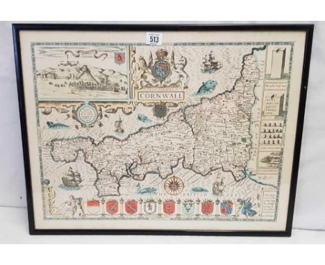
![Robert Morden (c. 1650 - 1703), by, two-page map, Darbyshire (sic, Derbyshire), [Published and] Sold by Abel Swale, Awnfham (](https://cdn.globalauctionplatform.com/97d93826-f715-4d0c-92ae-b09300c8a9cc/6694c144-f3aa-487d-bb9b-b0c2014666d1/468x382.jpg)

Lot 337
John Ogilby (Scottish 1600-1676) Hand coloured engraving "The Road from Glocester to Coventry", 17th century hand coloured engraved strip road map, framed and glazed. The road runs from Gloucester, through Winchcombe, Chipping Camden, Stratford on Avon and Warwick and ends at Coventry, 34cmx 44.5cm After John Collet Mezzotint "The Proverb Revers'd or, A Bird in the Bush worth Two in the Hand", printed and sold by Carrington Bowles, 1778, framed and glazed, image size 36cm x 26cm ( 2) Condition Report "The Proverb Revers'd..." print has plate marks. See photos.


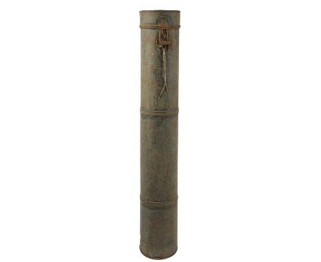
Lot 348
Royal Horse Guards and Napoleonic War period interest: a collection of maps and plans, the majority endorsed 'William Terry, Captn. Roy'l Reg. Horse Gds.' and dated 1809 and 1810, the maps (10) all of the High Wycombe area, giving details of troop dispositions and other information pertaining to the defence of the area, and including: 'Plan of the Advanced Guards at Four Ashes and Apple Common'; 'Sketch of the march of the Fourth Column of the Army encamped at Coleshill', with table of works necessary to clear the march; Plan of the Cantonments; Plan of Resources; the plans being of fortified lines in section (3), and in plan view (6), with one including a diagram of siege lines; and a tabulated list of regiments and quarters 'Sketch of a Table of Winter Quarters'; together with another map of the High Wycombe area endorsed 'Lt. St Martin, Watwiles Reg.', with title and captions in French showing theoretical troop positions and lines of fire, [21]; offered with the cylindrical metal plan case in which they have been kept.See lot 347 for Captain William Terry's commission.


Lot 108
Hartmann Schedel Das Buch der Chroniken und Geschichten. Augsburg, Joh. Schönsperger 1500. Zweite deutsche Ausgabe des sogenannten Kleinen Schedel von Schönsperger in Augsburg. Die am reichsten illustrierte Inkunabel überhaupt erschien erstmals 1493 auf Latein und nur sechs Monate später in deutscher Übersetzung. Der vorliegende Raubdruck von Schönsperger, eine Art Volksausgabe, enthält den Text in der Übersetzung von Georg Alt und verkleinerte Nachschnitte der Nürnberger Illustrationen. 'Man kann den Raubdruck von Schönsperger - der übrigens später zum Hofdrucker Kaiser Maximilians I. aufstieg - nicht nur vom verlegerischen Standpunkt aus beurteilen. Es gibt auch einen kunsthistorischen Aspekt, der den Nachschnitten des Raubdrucks eine gewisse Eigenständigkeit zuspricht. Denn diese repräsentieren trotz Motivübernahme eine andere Stilrichtung. Die 'Handschrift' des maßgeblichen der beiden Augsburger Zeichner, den wir namentlich nicht kennen, ist ausgesprochen malerisch, selbst im kleinen Format der zahllosen Halbfiguren. Daher erübrigte sich eine Kolorierung des Buches, die bei der Nürnberger Ausgabe noch einkalkuliert wurde' (Rücker). EINBAND: Schweinslederband des 16. Jhs. über Holzdeckeln mit Blind- und Rollenprägung sowie 10 Messing-Beschlägen. Folio. 28,5 : 20,5 cm. - ILLUSTRATION: Mit zahlreichen Textholzschnitten nach Wohlgemuth und Pleydenwurff. - KOLLATION: 312 (st. 317) num., 6 (st. 11) nn. Bll. - ZUSTAND: Auf Anfrage. - PROVENIENZ: Wappen-Exlibris 'Dr. H. T. Habbema, Nieuween en Uiterbuurt'(20. Jh.). LITERATUR: Hain 14512. - Goff S311. - BMC II, 375. - BSB S 199. - Schramm 5207. - Vgl. Rücker S. 143. - Second German edition of the so-called Small Schedel, a pirate edition by Schönsperger in a smaller size and with reduced woodcuts after Wohlgemut and Pleydenwurff. With numerous woodcuts in text. Contemp. blindstamped pigskin over wooden boards with 10 brass clasps. 312 (of 317) numb., 6 (of 11) nn. leaves. Lacking leaves 1, 3-4, 6, 281, the 2nd half of the Germany map, the index title and 3 index leaves. - Differently browned and stained, ca. 15 leaves damaged (loss of printed matter; mended), some longer tears (backed, affecting a part of the world map), partly with backed marginal defects, few quires detached or loosened (mostly at beginning, mended), 2 text passages blackened, front endpapers renewed. Binding stained, clasps removed. Armorial exlibris 20th century. Dieses Objekt wird regel- oder differenzbesteuert angeboten.
Lot 11
Abraham Ortelius Theatrum orbis terrarum. - Parergon, sive veteris geograp(h)iae aliquot tabulae. - Nomenclator Ptolemaicus. - Zusammen 3 Teile in 1 Band. Antwerpen, (R. Bruneau für) Jan B. Vrients 1603 (wohl 1606). • Überaus prachtvoll altkoloriertes Exemplar des berühmten Kartenwerkes • Ortelius setzte mit seinem ersten 'modernen' Atlas den Maßstab für alle nachfolgenden Atlanten • Vollständig mit den beiden Anhängen Parergon und Nomenclator sowie allen Karten • Mit 3 zusätzlichen Karten im Theatrum 'The unique position held by Ortelius' Theatrum in the history of cartography is to be attributed primarily to its qualification as 'the world's first regularly produced atlas' .. Shape and contents set the standards for later atlases' (Cornelis Koeman) Erste von J. B. Vrients besorgte lateinische Ausgabe, in nur 300 Exemplaren gedruckt. Vrients hatte die Platten samt Druckprivileg 1601 von den Erben von Ortelius erworben und damit 1602 bereits eine spanische Ausgabe des Theatrum herausgebracht. Wohl um 1606 gedrucktes Exemplar: die Ostfrieslandkarte Utrisque Frisiorum regionis ist 1605 datiert, und der Textteil zu Beginn mit den 5 kl. Karten als Textkupfer sowie die den 118 Karten des Theatrum hinzugefügten drei Karten 20*¹ Galliciae, 20*² Cataloniae (plus 1 Textbl. 20**) und 41* Limburgensis ducatus stammen aus der Ausgabe 1609 (vgl. Van der Krogt 31:054). Unter den schönen Karten die Weltkarte in Oval, Kontinentkarten von Europa, Afrika, Asien und Amerika, Karte des Pazifik und des Nordmeeres, zahlreiche Teilkarten, sowie die 38 historischen Karten, Kostümtafeln und Ansichten aus dem Parergon (num. j-xL). Sämtliche Karten in schönem leuchtenden Altkolorit. EINBAND: Lederband der Zeit mit verblaßter Goldprägung (Schließen fehlen). 45,5 : 31 cm. - ILLUSTRATION: Mit 2 kolorierten Kupfertiteln (Theatrum und Parergon ) und 1 kleinen kolorierten Titelvignette (Nomenclator ) 1 ganzseitigen kolorierten Wappenkupfer (verso Titel von Theatrum ), 1 kolorierten gestochenem Epitaph, 1 kolorierten Kupferporträt und 159 (statt 156) doppelblattgroßen Kupferkarten und -tafeln in Altkolorit, dazu 5 kl. kolorierte Kupferkarten als Textkupfer. - KOLLATION: 25 Bll.; 3 Bll.; 30 S., 3 Bll. - ZUSTAND: Auf Anfrage. - PROVENIENZ: Aus der Bibliothek von Bernhard Galura (1764-1856), Bischof von Anthedon und ab 1829 Erzbischof von Brixen, mit dessen hs. Besitzvermerk und 2-zeiliger Notiz auf dem vorderen Innendeckel sowie 2 Bll. hs. Index am Ende. LITERATUR: Koeman Ort 36. - Van der Krogt 31:053. - Phillips/Le Gear 419. - A beautiful and complete copy of the first 'modern' atlas by Ortelius. One of 300 copies from the first Latin edition by J. B. Vrients. He had acquired the plates along with the printing privilege from Orelius' heirs in 1601 and had already used them to publish a Spanish edition in 1602. Complete copy with all three parts 'Theatrum', 'Parergon' and 'Nomenclator'. With fullpage engr. coat of arms, 2 engr. title pages, 1 engr. title vignette, 1 engr. portrait and 1 engr. epitaph (both of Ortelius) as well as 156 plus 3 extra doublepage engr. mapsheets, all in bright contemporary coloring. Enlarged copy (probably printed around 1606) with 3 additional maps 20*¹, 20*² and 41* and the preliminary text with 5 col. text engravings (also maps) from the edition of 1609. Contemporary calf with faded gilt decoration (clasps removed). - 18 maps on verso of one of their halves with mounted engr. map from another cartographic work. - Overall slightly (finger-)stained and tanned, engr. title, first text leaves and ca. 10 maps and plates stronger affected, the orange coloring of 2-3 maps slightly blurred, Parergon with old ink stain to upper right of paper edges (maps only minim. affected), the map of the Holy Land in the Parergon with small defects in the colored surface, Nomenclator (without any maps) with waterstain to lower corner, text leaf C6 there with remargined part. Few maps and plates with mainly restored longer tear to margins, world map and Asia both with remargined part in upper resp. lower centrefold. Binding rubbed, claps removed, extremeties of spine skilfully restored. Overall fine and complete copy in bright contemporary coloring. - Copy from the library of later Archbishop of Mayence Bernhard Galura (1764-1856) with his ms. ownership entry and note on front pastedown and 2 ll. with ms. index in the end. Dieses Objekt wird regel- oder differenzbesteuert angeboten.

Lot 12
Frederick de Wit (Orbis maritimus ofte Zee Atlas.) Amsterdam um 1680. • Seltener Seeatlas von De Wit • Nahezu vollständiges Exemplar • Alle Karten in schönem alten Grenzkolorit 'De Wit muß als einer der bedeutendsten Kartenverleger der 2. Hälfte des 17. Jahrhunderts angesehen werden. Die meisten seiner Karten sind von hervorragender Qualität, sie zeichnen sich durch einen deutlichen schönen Stich, durch die Aktualität und Reichhaltigkeit des Kartenbildes sowie durch die Ausgewogenheit des Kartenschmucks aus' (Lexikon zur Geschichte der Kartographie) Seltene separate Ausgabe des schönen Seeatlas, der sonst meist als zweiter Teil von De Wits Atlas erscheint. Es fehlt der Titel und eine Datierung, vorhanden ist jedoch der vorhergesehene Bestand von 27 Karten in der Reihenfolge nach Koeman III, M. Wit 2 (dort datiert 'after 1680'), wobei die Karte des Ärmelkanals hier durch eine Fassung von Nicolaus Visscher ersetzt wurde. Wohl privat wurde dem Exemplar ferner statt des eigentlichen Titelblattes ein allegorisches Frontispiz aus Johannes van Keulens Seeatlas De nieuwe groote ligtende Zee-Fakkel (mit Adresse 'aande Oost zyde vande nieuwe Brug, in de Gekroonde Lootsman', ab 1684) und 6 Bll. Text Kort verhael, van's begin en de voortgangh der Scheep-Vaert vorgebunden. Dem folgt der Kartenteil mit einer figürlich reich geschmückten Weltkarte in zwei Hemisphären, der schönen, von zwei Platten gedruckten Europa-Karte (in westlicher Orientierung und wohl aus Platzgründen mit kurios versetzter Küstenlinie des östlichen Mittelmeeres mit Ägäis und Kleinasien ins nördliche Afrika), Teilkarten von Amerika und Afrika, ferner Nordpol, Nordmeer, Ostsee, westlichem und östlichem Mittelmeer, Südostasien und Indischem Ozean, Pazifik u. a. - Die Karten von Amerika liegen laut Burden 466-469 jeweils im zweiten Druckzustand 1675-1680 vor, u. a. wurde die Numerierung gelöscht. EINBAND: Gefleckter Lederband der Zeit mit etw. Rückenvergoldung und Rückenschild. 55 : 35 cm. - ILLUSTRATION: Mit allegorischem gestochenem Frontispiz (van Keulen) und 26 grenzkolorierten doppelblattgroßen Kupferkarten (st. 27; 1 mehrfach gefaltet) sowie 1 grenzkolorierten Kupferkarte von N. Visscher). - KOLLATION: 6 Bll. - ZUSTAND: Auf Anfrage. - LITERATUR: Koeman III, M. Wit 2. - LGK II, 899. - Rare separate edition of this sea atlas, which is more often found as the second part to De Wit's 'Atlas'. Without title or date, but probably published after 1680 (cf. the description in Koeman III, M. Wit 2). With 26 doublepage engr. maps (of 27; 1 folding) and 1 doublepage engr. map by N. Visscher (the English Channel), all in beautiful old outline color, showing amongst others a double hemisphere world map, a folding map of Europe, maps of the Arctic Sea, Atlantic Ocean, Pacific, Mediterranean, Indian Ocean, a polar chart etc. This copy with an allegorical engr. frontispiece and 6 leaves text from J. van Keulens 'Zee-Fakkel' (ca. 1684 or later) bound in at front, probably for a private collector. Contemp. mottled calf with some gilt decoration and label on spine. - Slightly stained, partly with rebacked small tear to fold, 2 maps with small, partly restored defects to lower margin, the map of Europe rebacked and slightly gluestained in the folds, with small, skilfully mended paperbreaks due to the oxidation of the outline coloring. Hinges and spine restored. Overall a well-preserved copy of the rare sea atlas with the beautiful maps. Dieses Objekt wird regel- oder differenzbesteuert angeboten.
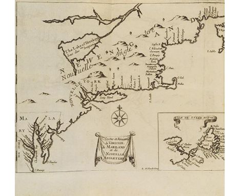
Lot 13
Henri Justel Recueil de divers voyages faits en Afrique et en l'Amerique. Paris, L. Billaine 1674. • Sammlung von Reisebeschreibungen • Sehr seltenes vollständiges Exemplar mit allen Karten und Tafeln • Darunter die große Karte des Nillaufs • Enthält ferner wichtige Teilkarten von Amerika Erste französische Ausgabe der Sammlung, eine Titelauflage erschien 1684. Zusammengestellt und herausgegeben durch den Gelehrten und Hugenotten Henri Justel (1619-1693), der als Sekretär von Louis XIV. tätig war, sich jedoch 1681 aus religiösen Gründen ins Exil nach England begab. Er wurde dort Königlicher Bibliothekar unter William II. - Enthält 10 Reisebeschreibungen von Afrika (Nilquelle und -lauf, Äthiopien, Westafrika) und Amerika (Barbados, Jamaika, Saint Christophe, Guyana). - 'The order of arrangement of the different parts is not the same in all copies, and some of the maps are often lacking. The large map of the Nile, entitled Imperii Abassini Tabula Geographica , is on four sheets, which are not pasted together in some copies.' (Sabin XVI, 417). - Vollständig mit allen Karten, darunter die Nilkarte, hier zu einem großformatigen Blatt zusammengesetzt, Karten der amerikanischen Ostküste Costes et rivieres de Virginie, de Mariland et de Nouvelle Angleterre (Burden 439) sowie der Antillen mit Jamaika Isle de la Iamaique (Burden 440) und Barbados Description topographique et mesure de l'Isle des Barbades aux Indes Occidentalles. Die Tafeln zeigen u. a. Palmen, Ananas, Bananenstauden und Granatapfel sowie Maschinen und Abläufe der Zuckerrohrverarbeitung. EINBAND: Kalblederband des 19. Jhs. mit etw. Gold- und Blindprägung auf Deckeln und Rücken sowie farbigem Rückenschild. 24 : 19 cm. - ILLUSTRATION: Mit 4 tlw. mehrfach gefalteten Kupferkarten, 12 Kupfertafeln (3 gefaltet) und 1 Karte als Textkupfer. - KOLLATION: 8 Bll., 262, 35, 23, 49 S., 1 Bl., 81 S. - ZUSTAND: Auf Anfrage. - PROVENIENZ: Jean-Jacques de Bure L'aine (1765-1853) mit dessen eigh. Kollationsvermerk (dat. 1832) auf Vorsatzblatt. Exlibris Armand de Saint-Ferriol (1817-1880). Exlibris Louis Duhamel und Henry Duhamel (Alpinist, 1853-1917). LITERATUR: Sabin 36944. - Alden/L. 674/158. - Nordenskiöld coll. 642. - First French edition of the collection, compiled by scholar and Huguenot Henri Justel, secretary to Louis XIV., until he went into religious exile to England in 1681 where he became royal librarian under William II. With important maps and descriptions of Africa and the Americas. With 4 engr. folding maps (including the often missing large map of the Nile printed on four sheets, here pasted together to one large folding sheet), 12 engr. and partly folding plates and 1 map as a text illustration. 19th cent calf with some blind and gilt decoration on spine and boards and label on spine. - Partly slightly stained, maps with occasionall tear to folds (but overall very well preserved). Binding rubbed, spine with 2 small missing pieces. - From the library of Jean-Jacques de Bure L'aine (1765-1853) with his ms. collation note on front flying endpaper (dat. 1832). Exlibris Armand de Saint-Ferriol (1817-1880). Exlibris Louis Duhamel and Henry Duhamel (alpinist and book collector, 1853-1917). Dieses Objekt wird regel- oder differenzbesteuert angeboten.
Lot 163
Johann Arnold von Brand Reysen durch die Marck Brandenburg, Preussen, Churland, Liefland, Plesscovien, Gross-Naugardien, Tweerien und Moscovien .. Anbei eine .. Beschreibung von Sibirien. Wesel, Jacobs 1702. Sehr selten erste Ausgabe. Beschreibt Von Brands Reise nach Moskau im Jahr 1673 im Gefolge der brandenburgischen Gesandtschaft unter Scultetus. Herausgegeben von H. Chr. von Hennin. Eine niederländische Ausgabe erschien 1703. - Der in Deventer geborene Verfasser Johann Arnold von Brand (1647-1691) war Professor in Duisburg. Sein erst posthum erschiener Bericht der Reise von Berlin über Kurland, Livland, Pskov nach Moskau enthält eine 'Beschreibung seiner Eindrücke, geographische und ethnographische Beobachtungen. Beigefügt sind eine kurze Beschreibung Sibiriens von Albrecht Dobbin sowie Anmerkungen zum Zobelfang.' (Nitsche/Stender S. 43) - Mit einer Faltkarte La Livonie von de Feuille (nicht im Kupferverzeichnis erwähnt) und Stadtplänen von Danzig, Königsberg und Riga, ferner Ansichten u. a. von Moskau, Trachten, Zobeljagd, Wappen, dem kyrillischen Alphabet, Samland mit Bernsteingewinnung u. a. EINBAND: Neuer Pergamentband mit farbigem Rückenschild. 16 : 10 cm. - ILLUSTRATION: Mit gestochenem Frontispiz, 1 gefalteten Kuperkarte, 1 gest. Kopfvignette und 15 meist gefalteten Kupfertafeln. - KOLLATION: 23 Bll., 516 S., 2 Bll. - ZUSTAND: Auf Anfrage. - LITERATUR: Adelung II, 118. - Winkelmann 687. - Nitsche/Stender 76. - Very scarce first edition, the only other edition appeared a year later in Dutch. With engr. frontispiece, engr. head vignette, 1 engr. folding map and 15 mostly folding engr. plates with plans of Danzig, Königsberg and Riga, views, costumes, coat of arms, the cyrillic alphabet etc. Mod. vellum with label on spine. - Evenly tanned. Dieses Objekt wird regelbesteuert angeboten (R).

Lot 168
Andreas Cellarius 3 Himmelskarten aus der Harmonia Macrocosmica . Kolorierte Kupferstiche. Amsterdam, Valk und Schenk 1708. Je ca. 45 : 50 cm. Aus der späteren Auflage des schönen Himmelsatlas. Mit Verlegervermerk von Schenk und Valk in den Titelkartuschen und Numerierung in der unteren rechten Ecke. - Vorhanden Tafel 4 Planisphaerium Copernicanum mit kleiner Polkarte und in den unteren Ecken Porträts von Kopernikus und Ptolemäus, Tafel 11 Situs terrae circulis coelestibus circumdatae (gest. von J. van Loon; mit Darstellung von Südostasien und angedeuteter Küstenlinie von Papua-Neuguinea und Australien) und Tafel 22 Coeli stellati christianae haemisphaerium prius mit den christlichen Sternbildern des südlichen Nachthimmels (Hiob, Abraham und Isaak, Arche Noah etc.) nach Julius Schillers Himmelsatlas Coelum stellatum Christianum (1627). - ZUSTAND: Auf Anfrage. - LITERATUR: Van der Krogt HM04:1; HM11:1; HM22:1. - Collection of 3 col. engravings with 3 celestial charts. From Cellarius' 'Harmonia macrocosmica' in the later edition 1708 by Valk and Schenk, with publisher's name in title cartouches and numbering in the lower right corner. Depicting amongst others a hemisphere with a map of Southeast Asia and the presumed coastline(s) of Papua New Guinea and Australia, and the Christian constellations of the Southern sky after J. Schiller. - With few restored marginal tears, otherwise clean copies. Matted and framed. Dieses Objekt wird regel- oder differenzbesteuert angeboten.
Lot 169
Jacob Aertsz Colom De vyerighe Colom .. Spiegel der Zee. Deze Tweede Druck vermerdert met ontrent hondert figuren, vertoonende der sanden en landen gelegentheyt en opdoeninge uyt de Zee. 6 Teile in 1 Band. Amsterdam, J. A. Colom 1642-1645. Seltener und berühmter See-Atlas mit prachtvollen Karten von Europa. Nach Koeman in einer Titelvariante der zweiten Ausgabe vorliegend, erschien erstmals 1632. Der Titel ist 1642 datiert, die Einzelteile 1644 bzw. 1645 sowie mit dem Vermerk 'de derde druck vermeerdert'. 'The bibliographical treatment of the pilot guides and sea-atlasses published by Jacob Aertsz Colom is quite incomplete due to lack of material. Undoubtly thousands of copies were circulated: however, only a score have survived' (Koeman). Der Drucker und Kartograph Jacob Colom (1600-1673) stieg in den niederländischen Kartenmarkt ein, als dieser von Blaeu und Janssonius und deren immer größerer und aufwendiger werdenden Atlanten beherrscht wurde. Während die Häuser Blaeu und Jansson um deren Herausgabe konkurrierten, nutze Colom die Nische für einen effektiv funktionierenden Pilotenführer, mit dem er großen Erfolg erzielte. Die prachtvollen Seekarten zeigen die Küsten von Skandinavien, der deutschen Nord- und Ostsee (zus. 16), Baltikum (2), England mit Schottland und Irland (12), Niederlande und Frankreich (zus. 9), Portugal und Spanien (zus. 7), afrikanische Westküste (1) und Kanarische Inseln (1). Die Zwischentitelblätter jeweils verso mit der linken Hälfte einer Karte bedruckt. - Nach der Kollation der Erstausgabe bei Koemann fehlt hier wie fast immer die Europa-Karte zu Beginn, die Pascarte van Barbarischer cust (Karte 40) ist laut Verzeichnis auf dem letzten Blatt in dieser Ausgabe nicht erschienen, ebenso wohl Karte 15 (nach Koeman kleinformatig), da 14 in einer größeren Variante vorliegt (vgl. Koeman J. Col 9, Nr. 14). EINBAND: Blindgeprägter Lederband d. Zt. über Holzdeckeln. 43 : 29 cm. - ILLUSTRATION: Mit illustriertem Kupfertitel und 48 doppelblattgroßen Kupferkarten (st. 49). - KOLLATION: 15 nn. Bll., 94 S., 96 S. - ZUSTAND: Auf Anfrage. LITERATUR: Koeman J. Col 8 B. - Famous see atlas. Title variant of the second edition. With illustrated copper title and 48 doublepage engr. maps (of 49). Contemp. blindstamped calf over wooden boards. 43: 29 cm. - As often lacking the map of Europe. - Browned and stained, waterstained almost throughout (partly stronger), the maps mostly trimmed to the edge of the plate, some also with some image loss; engr. title, the 15 prelims, the first leaves of part I, last text leaf and Africa map remargined (therefore occasional loss of text and the first 3 maps as well as the Africa map with some loss of images), map of Spain with small edge tear, map of France with small holes in the margins, otherwise only a few small marginal damages. Binding heavily bumped and with large missing parts in the leather cover, clasps removed. Dieses Objekt wird regel- oder differenzbesteuert angeboten.

Lot 182
Jaques Le Roy Le Grand Theatre Profane du Duche de Brabant. Contenant la Déscription Generale & Abregée de ce Pais. 2 Teile in 1 Band. Den Haag, Chr. van Lom 1730. Schönes Ansichtenwerk zu Brabant, geschätzt wegen der reizvoll ausgeführten Ansichten von Städten, Burgen, Schlössern und Landschaften. Erste französische Ausgabe. Titel in Rot und Schwarz. - Der zweite Teil mit dem Titel Le Grand Theatre Profane du Brabant-Wallon . EINBAND: Zeitgenössischer Lederband mit reicher Rückenvergoldung. 45,5 : 29 cm. - ILLUSTRATION: Mit gestochener Titelvignette, 4 Wappen-Kupfertafeln, 1 gestochenen Münztafel, 1 gestochen Karte und 188 Kupfern auf Tafeln sowie 4 Wappenkupfern im Text. - KOLLATION: 2 Bll., 64 S.; 2 Bll., 151 S. - ZUSTAND: Auf Anfrage. - PROVENIENZ: Exemplar aus altem französ. Adelsbesitz: im Vorderdeckel mit Besitzerschildchen 'M. le Bon G. De Joigny'. Zuletzt seit Jahrzehnten in einer europäischen Privatsammlung. LITERATUR: Bibl. Belgica III, 854f. - Brunet II, 1699. - Vgl. Funck S. 352. - Beautiful work of views of Brabant, appreciated for the charmingly executed views of cities, castles, palaces and landscapes. With engraved title vignette, 4 coats of arms copper plates, 1 engraved coin plate, 1 engraved map and 188 engravings on plates and 4 coats of arms copper plates in the text. Contemp. calf with back gilt. - Excluding the last 6 leaves (index and errata). Only slightly browned in places, title page with marginal cut (without loss of text). Capitals somewhat damaged, joints restored, overall fine copy. Dieses Objekt wird regel- oder differenzbesteuert angeboten.
Lot 183
Gerard Mercator [Atlas minor, das ist: eine kurtze jedoch gründliche Beschreibung der gantzen Welt. Amsterdam, J. Janssonius um 1651]. Der bekannte kleinformatige Atlas mit der schönen Weltkarte in zwei Hemisphären und Kontinentkarten von Europa, Afrika, Asien und Amerika. Ohne die bei einigen Exemplaren hinzugefügte, jedoch bei Koeman nicht angegebene Karte von Kleve. Enthält ferner eine Polkarte und zahlr. Länderkarten von Europa, Afrika, Asien und Amerika. Meist mit Schmuckkartusche und teils mit figürl. od. maritimem Beiwerk geschmückt. - Unvollständiges Mischexemplar: Die Weltkarte und die 4 Kontinentkarten hier aus der französischen Ausgabe (umseitig mit französischem Text S. 3-4, 7-8 und 11-20. Ab S. 21-644 (von?) lateinische Ausgabe mit Sprüngen und Lücken in der Pagination. EINBAND: Halblederband im Stil der Zeit mit Pergamentbezug. 17 : 24,5 cm. - ILLUSTRATION: Mit 136 ganzseitigen Kupferkarten (von ?; 5 koloriert). - ZUSTAND: Auf Anfrage. - PROVENIENZ: Exlibris des preußischen Generals Konstanz Heineccius (1859-1936). - Mixed edition of an incomplete copy: with pp. 3-4, 7-8 and 11-20 (including 5 maps) from a French edition, and p. 21-644 (of?) from a Latin edition, with gaps and jumps in the pagination. With 136 (of?, 5 col.) fullpage engr. maps, the double hemisphere world map and continent maps of Europe, Africa, Asia and America all in old coloring, as well as polar chart and numerous regional maps of Europe, Africa, Asia and America. This copy without the extra map of Cleve (added to some copies, but not listed by Koeman). Half calf with vellum covers (rubbed and stained). - Lacking amongst others the engr. title and the first preliminary leaves (text starts at p. 3). Stained and with traces of use. Dieses Objekt wird regel- oder differenzbesteuert angeboten.
Lot 188
Carsten Niebuhr Reisebeschreibung nach Arabien und andern umliegenden Ländern. Band I und II (von 3). Kopenhagen, N. Möller 1774-78. 'Das an gesicherten Daten reichhaltigste und nützlichste Werk asiatischer Forschungsliteratur des 18. Jahrhunderts' (Dietmar Henze). Erste Ausgabe der erweiterten Fassung von Niebuhrs Bericht über seine Forschungsreise nach Ägypten, Arabien, Indien, Irak, Syrien und die Türkei in den Jahren 1761-67. Gegenüber der einbändigen Erstausgabe (siehe Beigabe) 'beträchtlich erweitert und wesentlich reicher illustriert' (Griep/Luber). Ein dritter Band erschien erst 1837 (bei Perthes, Hamburg), 22 Jahre nach Niebuhrs Tod. - Die Kupfertafeln, die meisten auf leicht bläulichem Papier gedruckt, zeigen Ansichten, Altertümer, Panoramen, Einwohner, Trachten, Hieroglyphen, Monumente, Musikinstrumente, Spiele u. v. m. EINBAND: Halblederbände der Zeit mit 2 farbigen Rückenschildern. 26 : 21 cm. - ILLUSTRATION: Mit 2 gestochenen Titelvignetten (wdh.), 100 Kupfertafeln (34 gefaltet) sowie 25 gestochenen Karten und Plänen (14 gefaltet). - KOLLATION: XVI S., 3 Bll., 504 (recte 505) S.; 8 Bll., 479 S. - ZUSTAND: Auf Anfrage. - LITERATUR: Griep/Luber 1011. - Ibrahim-Hilmy II, 66. - Jolowicz 473. - Gay 3589. - Henze III, 610f. - DSB X, 117. Dabei: Ders., Beschreibung von Arabien. Kopenhagen, N. Möller 1772. Mit gestochener Titel- und Kopfvignette, 18 Kupfertafeln (4 gefaltet, 2 farbig), 7 Kupferkarten (6 gefaltet, 1 grenzkoloriert) und 1 gefalteten Stammbaum. Halblederband der Zeit mit farbigem Rückenschild. 25,5 : 19,5 cm. - Tl. leicht stockfleckig, Vorsätze in den Ecken leimschattig, auf die Faltkarte abgefärbt. Rücken und Gelenke etw. beschabt. - 'The most comprehensive and most useful works of scientific literature on Asia in the 18th century' (Henze). First revised and enlarged edition. Vols. I and II (of 3). With 2 engr. title vignettes (rep.), 100 (34 folding) engr. plates and 25 (114 folding) engr. maps, most of them printed on light blue paper. Contemp. half calf with 2 labels on spine. - Only slightly stained, overall clean copy. Bindings rubbed, 2 joints of vol. II with small tear, 1 label missing. - And: Idem, Beschreibung von Arabien. Copenhagen, N. Möller 1772. With engr. title vignette, engr. text vignette, 18 engr. plates (2 in color, 4 folding), 7 engr. maps (1 with outline color, 6 folding) and 1 folding genealogical tree. Contemp. half calf with label on spine. First edition. - Partly slightly foxed, endpapers gluestained in places, setting off to the folding map. Spine and hinges somewhat rubbed. Dieses Objekt wird regelbesteuert angeboten (R).

Lot 190
Adam Olearius Colligirte und viel vermehrte Reise-Beschreibungen. Hamburg, Z. Hertzel und T. Wiering 1696. Posthum erschienene Sammelausgabe der von Olearius verfaßten oder herausgegebenen sämtlichen Reisewerke. Enthält 5 Teile und 2 Anhänge: I. Reise-Beschreibungen nach Mußkau und Persien. Mit Kupfertitel, 5 Porträttafeln, 15 (st. 19) gest. Falttafeln, 3 Kupferkarten (darunter gr. gefalt. Wolgakarte) und 77 Textkupfern. 6 Bll., 403 (recte 397) S., 7 Bll., 1 Bl., 76 (recte 74) S. - II. Orientalische Reise-Beschreibung: Jürgen Andersen .. und Volquard Iversen. Mit Kupfertitel, 1 gest. Falttafel, 20 Textkupfern, und 3 gest. Faltkarten. 2 (st. 4) Bll., 175 S., 2 Bll. - III. Johann Albrechts von Mandelsloo Morgenländische Reise-Beschreibung. Mit Kupfertitel, gest. Porträt-Titelvignette und 28 Textkupfern. 4 Bll., 174 S., 5 Bll.; 112 S. - IV. Saadi. Der persianische Rosen-Thal. Mit Kupfertitel und 30 (st. 34) Textkupfern. 9 Bll., 111 (st. 119) S., 6 Bll. - Ohne die Lage F. - V. Saadi. Der persianische Baum-Garten. Mit Titelvign. und 11 Textkupfern. 4 Bll., 116 S. (st. 120). - Fehlen 2 Bll. der Lage O. EINBAND: Neuer Velour-Lederband über Holzdeckeln im Stil d. Zt. unter Verwendung der 8 alten Messing-Eckbeschläge mit Buckeln und der 2 alten Messing-Schließen. 36,5 : 23 cm. - ILLUSTRATION: Mit 4 Kupfertiteln, 2 gestochenen Titelvignetten, 5 gestochenen Porträttafeln, 16 (st. 20) Kupfertafeln und 6 gestochenen Karten und 166 (st. 170) Textkupfern. - ZUSTAND: Auf Anfrage. - LITERATUR: Dünnhaupt 3002, 53 (mit weiteren Literaturangaben). - Posthumously published collective edition of all travel works written or edited by Olearius. With 4 engrl. titles, 2 engr. title vignettes, 5 engr. portrait plates, 16 (of 20) copperplates, 6 engr. maps and 166 (of 170) text coppers. New velor leather over wooden boards using the 8 old brass corner fittings with buckles and the 2 old brass clasps. 36.5 : 23 cm. - Lacking togther 8 leaves and 4 plates. Thoroughly restored copy, each leaf has been processed. Here and there loss of illustration and letters (mostly at the outermost text area, 1 leaf larger), Volga map with longer tear. Dieses Objekt wird regel- oder differenzbesteuert angeboten.
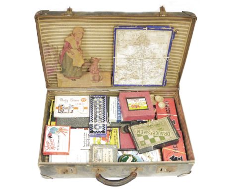
![Moses Pitt The English Atlas [vol. III], containing the description of the remaining part of the empire of Germany. Teil I](https://cdn.globalauctionplatform.com/640d93f1-2a59-4cda-87a9-b0b500e405c9/83fe933b-3a05-4f0c-a67d-b0b500ec9f6f/468x382.jpg)
Lot 191
Moses Pitt The English Atlas [vol. III], containing the description of the remaining part of the empire of Germany. Teil II (von 2). Oxford, M. Pitt 1683. Prächtiger altkolorierter und breitrandiger Atlas mit Goldhöhung. Vorhanden der zweite Band des Deutschland bzw dem Hl. Römischen Reich gewidmeten Teils aus dem großen, nach Band IV (Niederlande) aus finanziellen Gründen unvollendet gebliebenen Atlaswerks. 'Der Imperial-Folioband enthält vor allem Karten von Süd- und Westdeutschland, darunter eine Faltkarte des Weserlaufs sowie Karten von Österreich, Ungarn, Tirol, Trient, Bulgarien, Friesland u. a. Regliertes Exemplar, die Karten in prachtvollem Altkolorit mit Goldhöhung, die Holzschnitt-Vignetten und Initialen im Text ebenfalls koloriert und mit Goldhöhung versehen. - Fehlen das Porträt von Maria-Beatrix von York und die Karten der Donau, Jülich und Berg. EINBAND: Roter Maroquinband der Zeit mit reicher Deckel- und Rückenvergoldung sowie Goldschnitt. 62 : 41 cm. - ILLUSTRATION: Mit 42 doppelblattgroßen kolorierten und goldgehöhten Kupferkarten (st. 45; 1 gefaltet). - ZUSTAND: Auf Anfrage. - PROVENIENZ: Titel und letztes Bl. mit Stempel, Innendeckel mit Exlibris und Ausgeschieden-Stempel. - LITERATUR: Koeman/Van der Krogt I, 1:451.3.- Vol. III of the English atlas by M. Mitt, which contains the 2nd part (of 2) of the section of Germany (i.e. the Holy Roman Empire) with maps mainly of South and West Germany as well as maps of Hungary, Bulgaria, Austria and Northern Italy. Splendid gilt-heightened atlas with broad margins and old coloring. Ruled copy. Contemp. red morocco with rich gilt tooling. With 42 double-page colored and gilt-heightened copper maps (of 45). - Slightly foxed and fingerstained, margins slightly tanned and occasionally with small rebacked tears, 1 map with torn-off corner. Binding somewhat stained and rubbed, hinges restored. - First and last leaf with stamp, inner front board with bookplate and cancellation stamp. Dieses Objekt wird regel- oder differenzbesteuert angeboten.


-
109182 item(s)/page