We found 109182 price guide item(s) matching your search
There are 109182 lots that match your search criteria. Subscribe now to get instant access to the full price guide service.
Click here to subscribe- List
- Grid
-
109182 item(s)/page


Lot 51
A hand-coloured map (in three sections) by Roderick Impey Murchinson (1792-1871), latterly published in part in Murchison's 'The Silurian System...' c 1839. One part is hand signed by Murchison and all are linen backed.One 'Order the Sedentary Deposits...' 53,5 x 96cmTwo 'Ideal Section - Submarine Relations...' 52 x 96cmThree 'Sea Rocks..' 49 x 96cmPurchased by the vendor from Manchester Library c 1990s and with original purchase receipt.

Lot 80
Die Geschichte des JimutavahanaNordchina, Wutai shan (?), 19. Jh.86 x 53 (150 x 74) cmJimutvahana war der weise Sohn von Jimutaketu, König der Vidyadharas. Als sein Vater Asket wurde, gab er unter anderem einen himmlischen Baum in dessen Obhut der den Menschen gewährte, was immer sie an Gutem begehrten. Aber Jimutvahana konnte nicht fernab von seinem Vater leben und folgte ihm in den Wald. Da kehrte der Baum zurück ins Paradies. Eines Tages sah Jimutavahana an einer Wasserquelle ein Mädchen von göttlicher Schönheit, und es wurde ihm offenbart, dass es die Tochter vom König der Siddhas war. Die beiden jungen Leute verliebten sich. Der Hochzeitstag rückte näher und in der Stadt der Siddhas wurden in Erwartung der Ankunft des Vidyadhara-Prinzen Jimutavahana große Festivitäten gegeben. Er traf in einem Himmelswagen ein. Die Hochzeitsfeierlichkeiten fanden sogleich mit großem Pomp und großer Prachtentfaltung statt. Sechs Tage später hörte Jimutavahana im Wald das klägliche Jammern einer Schlange, die die bevorstehende Opferung ihres Sohnes beklagte: Dieser sollte gemäß einem alten Brauch einem Garuda geopfert werden. Jimutavahana beschloss, den Naga durch die Aufopferung seines eigenen Lebens frei zu kaufen, und nach dem er sich unter einem Vorwand die roten Bänder beschafft hatte, die das Opfer tragen sollte, begab er sich zum Berggipfel. Der Garuda, der am Himmel große Kreise beschrieb, stürzte herab, riss Jimutavahana mit seinen Klauen in Stücke und schnappte sich den Edelstein vom Kopf. Jimutaketu, der mit seiner Frau und seiner Schwiegertochter im Wald zurückgeblieben war, grämte sich zutiefst über die Verspätung seines Sohnes, denn er wusste, dass an eben jenem Tage der Garuda hernieder kommen würde. Noch viel größer war seine Sorge, als der Edelstein, der den Kopf seines Sohnes geziert hatte, zu seinen Füßen herab fiel. Er lief mit Bangen den Berg hinauf und kam gerade rechtzeitig, um den Bericht von der Aufopferung seines Sohnes vom sterbenden Jimutavahana selbst und von dem Naga den er gerettet hatte, zu hören. Der Garuda bereute und schwor, sich für immer der Opfer zu enthalten, die er bis zu diesem Augenblick gefordert hatte. Inzwischen hatte Jimutavahana sein Leben ausgehaucht, als sich seine Frau anschickte, auf seinem Scheiterhaufen ebenfalls zu sterben. Sie betete im zukünftigen Leben mit ihrem Mann verbunden zu sein. Aber in diesem Augenblick erschien Parvati und brachte Jimutavahana wieder zum Leben. Dieser bat darum, dass die Nagas, die in der Vergangenheit vom Garuda getötet worden waren, wieder belebt werden mögen. Jimutavahana war der Buddha, der den Mönchen, die Geschichte aus seinem früheren leben erzählte.Rechts unten erscheint Jambhala, der Gott des Reichtums, inmitten der beiden Stifter - ein Lama und ein Laie (in mongolischer Kleidung) - umgeben von Dienern und Verwandten die der Gottheit in verehrungsvoller Haltung Opfergaben darbringen.Die schwerlesbare Inschrift in der Kartusche nennt die Namen der beiden Stifter Gyur-med ye-shes tshe-brtan und Gyur-med nam-rgyal rdo-rje.Der Widmungstext in tibetischer Sprache lautet, übersetzt: „Als er in früherer Zeit (der Bodhisattva) sPrin-gyi gzhon-nu war, wurde zwar sein eigener Körper - um das Leben der anderen zu schützen - zur Nahrung für den furchterregenden (Garuda) mKha-lding dbang-po. Mittels der Macht der Wahrheitsworte wurde er (danach aber) gleichsam wieder wie zuvor (und) wirkte für das Wohl der Wesen.Der in der Poesie gelehrte Dharmaraja Kshemendra fügte den Taten (des Shakyamuni Buddha) der verbliebenen 107 Blattzweige den einen Blattzweig hinzu, der vom Prinzen Zla-Bai dbang-po (verfasst worden war): enthalten (sind in der Bodhisattvavadanakalpalata somit) die vollständige Anzahl von 108 Erzählungen.“ „Durch den Glanz des Himmelsjuwels der Handlungen der hier (gezeigten) Bemühungen werden alle Unstimmigkeiten gänzlich beruhigt (und) die nahen Freunde und Verwandtenvertragen sich.Mögen vorläufig das religiöse (und) das weltliche Gesetz im Überfluss der Freude ausgeübt werden (und) letztendlich schnell die Stufe der Allwissenheit (der Buddhaschaft)erlangt werden.Möge es Glück bringen!“Tempera auf Baumwollgewebe, originale Brokateinfassung mit Schutzvorhang, Stäben und Silberknäufen. Es ist das letzte Bild aus einer Serie von 31 Thangkas mit 108 szenischen Bildern (Jatakas) und den Erzählungen über die die früheren Leben des Gautama Buddha Shakyamuni. (s. beigefüges Begleitheft!).Alte süddeutsche Privatsammlung, vor 2007 gesammeltLiteratur: Harry Halén, Mirrors of the Void, Buddhist Art in the National Museum of Finland, 63 Sino-Mongolian thangkas from the Wutai Shan workshops, a panoramic map of the Wutai Mountains and objects of diverse origin. Helsinki, 1987; G. Tucci, Tibetan Painted Scrolls; La Liberia Dello Stato, Roma MCMXLIX (1949) p. 533, Thangka 94, Plate 130Etwas berieben und rest., Altersspuren

Lot 1802
Gruppe von drei Karten bzw. BüchernKorea/ Japan, 19. Jh.29 x17,5/ 86 x 67/ 47 x 33,5 cm1) Einband, Korea, Titel: Yeojijeondo (Complete map of imperial territory), Das Atlas enthält zwölf handgemalte bzw. -gezeichnete Karten: Karten von Präfekturen Koreas, gefolgt von Karten für China, die Ryukyu-Inseln und Japan. Am Ende befindet sich eine Weltkarte, die wohl 81 Länder zeigt. Die Karten sind mittig auf jeder Doppelseite des Bandes platziert. Es handelt sich hierbei um eine spätere Kopie aus dem 19. Jahrhundert nach dem Vorbild eines Druck-Altlas namens „Yeochudo“ aus der Ming-Dynastie, wobei die Übersichtskarte von Korea fehlt. In Tusche handgeschriebener Text wohl vom Stifter datiert auf das renwu-Jahr (1822 od. 1882); 2) Karte vom Edo-jō, Japan, Farbholzschnitt. Historische Karte von dem japanischen „Burg Edo“ und der Umgebung Ausgabe 1824, Verlag: Suharaya Mohei 須原屋茂兵衛. 3) Kleine Karte, JapanFarbholzschnitt, Titel: Tempō kaisei shuchu Kyo ezu (Überarbeitete Taschenkarte von Kyoto in der Tempō-Periode / Revised pocket Map of Kyoto in the Tempō era) Ausgabe 1841, Autor: Ikeda, Toritei, Verleger: Takehara Yoshibē.Aus einer alten deutschen Privatsammlung, vor 1990 gesammeltAltersspuren, teils etwas besch.
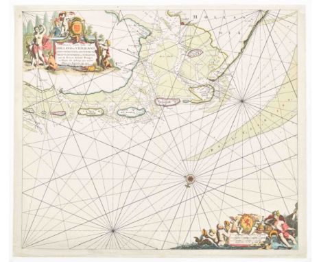
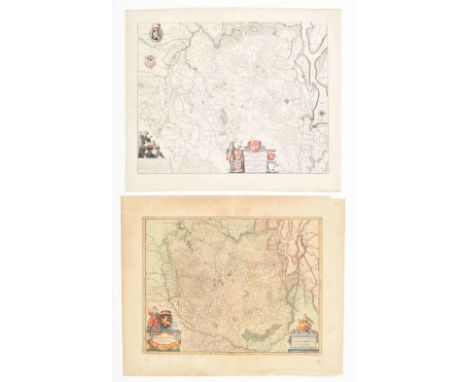
Lot 1125
van Holland en Vriesland. Groeninger, Emder en Reydingerland, Holstyn, Ditmarsche en't Eydersted. Amst., Joannes van Kuelen (=van Keulen), ca. 1680. 52 x 60 cm. 2 beautifully col. allegorical cartouches w. title, scales and coat of arms. The right part of a nautical map that was publ. on 2 double folio sheets. Professionally restored, backed w. Japanese paper.

Lot 920
varvattende haar begin, opkomst, toeneming, en verdere stant (...). Dordrecht, S. onder de Linde, 1687. (16),1358,(24) p. 4to. Incl. the following etched/ engr. plates outside collation: frontisp.; fold. profile; large fold. map; 10 portraits; 1 large fold. plate w. coats of arms; 4 large fold. historical prints by Romeyn de Hooghe and others (strictly following the binder's index at the end); 1 extra large fold. portrait of Andreas Colvius by S. Savery, 1646; and many woodcut (some engr.) coats of arms in the text. Very finely bound in late 18th cent. richly gilt red morocco by the "Curved Lacework Bindery" of Hendrik de Haas (active 1765-1800), richly dec. covers, turn-ins, board edges and spine w. dec. compartments between raised bands, a.e.g., gauffered border, corner fleurons, w. the orig. marbled board slipcase and mor. letterpiece preserved, loosely inserted business card of Mr. C. Baron Speijart van Worden (Breda), w. manuscript annotation: "Den Weledelgeboren Heer J.J.G. Blussé van (printed name) met beleefde dankzegging voor verleend gebruik."Fold. map and plate w. coats of arms backed, the latter w. large tear, occas. sm. internal defects such as sl. waterst, the letterpiece on the spine might be of a later date, sm. scratches on binding, otherwise in excellent condition. Storm van Leeuwen, Dutch Dec. Bookbinding, IIA, p. 500-510, mentions Blussé as client of Hendrik de Haas. This copy w. fine provenance: it has always been in the Blussé family, known for the famous Dordrecht publ. and bookseller's firm Blussé, given by descent to the present owner. Nijhoff/ Van Hattum 17; Landwehr, Romeyn de Hooghe as Book Ill., 45. See also lot 281 in this auction.
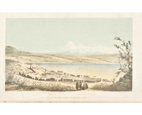
Lot 1067
en Palestina in 1851 en 1852. Utrecht, Kemink en zoon, 1854. 1st ed. 2 vols. 334; 429 p. 8vo. Contemp. hcl. w. marbled paper, manuscript signature of former owner (?) on flyleaf, "D.C. Pund Willemstad", 2 col. lithogr. frontisp., fold. lithogr. map w. handcol. route and plan, fold. plate map of Jerusalem and fold. plate with Hebrew, Arabic and Greek writing w. ill.Sl. foxing and fold. plates have some tears, otherwise in fine condition. (total 2)

Lot 376
ou l'on voit leurs progrès, leurs conquêtes, leur Gouvernement, et celui de leurs Compagnies en Orient & en Occident (...). Amst., J. Malherbe, 1701. (6),169,(3) p. Leather, title with vignette, complete w. all 6 plates (incl. world map) and numerous vignettes in the text.-and another copy of the same, lacks world map. Both shabby copies. Sold w.a.f. (total 2)
![Zes jaren aan den Congo en de stichting van een nieuwen vrijen staat. [&] Hoe ik Livingstone vond. U. h. Engelsch. Amst./](https://cdn.globalauctionplatform.com/fefecb27-123d-44f0-a377-af4c009e107c/1175cfb0-6c26-4b0d-8efa-af4c015489e7/468x382.jpg)
Lot 1063
Zes jaren aan den Congo en de stichting van een nieuwen vrijen staat. [&] Hoe ik Livingstone vond. U. h. Engelsch. Amst./Brussel, P. Maes, 1886. 3 vols. Sm. folio. Contemp. hcalf w. marbled boards, ribbed spines and gilt lettering, 5 fold. maps, 11 col. chromolithogr. plates and approx. 430 other ills.Sl. worn, (mostly marginal) foxing, 1 map loose. (total 3)

Lot 1104
Verso Descr. Goesae, fortification plan from a Latin ed. of the "Stedenboek". Amst., 1649. 38 x 50.5 cm. Col.(2) Joan Blaeu. Verso Descr. Goesae. (3) Isaak Tirion. Kaarte der eilanden Noordbeveland, Wolphartsdyk en Oostbeveland. Amst., D.W.C. and A. Hattinga, 1753. 31 x 39 cm. Col. (4) Isaak Tirion. Kaart van het eiland Zuidbeveland. Amst., W.T. Hattinga, 1753. 34 x 43 cm. Col. (5) J. van Jagen. Nieuwe kaart van de Provintie Zeeland. Amst., Jacobus Kok, ca. 1780. 32 x 40 cm. Fold. and col. map after J.C. Reeder. -and 1 other small fort. plan of Goes. (total 6)

Lot 857
Superb and rare cut glass on the Colonial Trade exposition held in Amsterdam, 1883. One of the buildings and floral decoration, on rim foot glass. H. 14 cm. Added: (2) 16 col. lith. plates and 1 double-page col. lith. "Plattegrond van het tentoonstellingsterrein". Loose as published in original envelope with colour-lith. title, 12 x 18 cm. Envelope dam. Overcomplete set (6 lith. and map in repeat). (3) Herinnering Amsterdam. Met 16 stadsgezichten, 1883. J.F. Haeseker & Co, Haarlem. Cover severely dam., plates good. (total 3)

Lot 1094
Eleganter Distinctus (...). Amst., Petrus Schenck. ca. 1720. 60 x 49 cm. Large allegorical cartouche w. dedication Dno Harmanno de Wilde, chiliarchae Trajecti ad Mosam and his coat of arms. Partly glued on cardboard, some paper missing outside the map image.(2) Partie Septentrionale du Duché de Brabant. H. Paris, Jaillot, 1720. 48 x 78 cm. Fold. in middle, sides w. tears and missing paper outside the map image. -and 8 other Brabant maps in various conditions w. a.o. a Visscher and a Hondius map. 17th to 19th cent. Sold w.a.f.,not subject to return. (total 10)

Lot 329
Venice, Gabriel Giolito de Ferrarie Fratel, 1553. 1st ed. (12),309,(1) p. Large 8vo. Rebound in green leather w. gilt title on spine, ex libris G. Fumach, title in woodcut historiated architectural border, 84 woodcut text ills., historiated letters begin each canto, half p. woodcut zonal world map incl. the Americas, last leaf with printer's device, printed in italics in 2 columns.1st ed. of Dolce's Italian transl. of Ovid's Metamorphoses in ottava rima. Sl. foxing. In excellent condition, beautiful work.

Lot 1173
(1) De rivier de Merwede van (omtrent) de Steenen-Hoek, oostwaards-op, tot verby het dorp van Sleeuwyck (...). (2) De rivier de Merwede, van even boven het dorp Steenwyk (...) en Loevesteyn, etc. (3) Caarte ofte afteeckening van de rivier de Merwede van Gorinchem af benedenwaarts, etc. N.pl., ca. 1730. 53.5 x 64 cm (2) and 53 x 63 cm. Final map framed.The first 2 maps w. tape stains in blank margins and generally sl. stained, all w. vertical folds as publ. Rare complete set of 3 maps, of which the first 2 can be joined together to form one large map. This map set a standard for Dutch river mapping to help find a solution to the frequent flooding of a vast low-lying area along the south river bank called the Biesboch.

Lot 1172
met alle de Steden, Dorpen, Ambachten, Litmaten, Polders, etc. N.pl., 1712. Obl. large folio. Contemp. mottled calf w. raised bands, gilt and ribbed spine, gilt lettered 'Delflant' on both sides, remnants of 8 ties, engr. title on 2 lvs., followed by engr. general map in splendid handcol. and heightened w. gold, and 25 numb. engr. maps (each measuring 515 x 590 mm) by T. Doesburgh, L. v. Anse, J. & J. Deur & P. Sluyter after N. & J. Kruikius & A. Houbraken (forming, when put together, a wall map of 260 x 280 cm), all in plano (unfolded), several maps flanked by fine large armorial cartouches.Binding weak on upper inner hinge, covers worn and lacking portions of leather, the 2 title lvs. w. central waterst., leaf 16 and the final 2 lvs. stained in lower part of the image, the other lvs. marginally waterst. (esp. in upper blank margin/ upper inner corner), occas. sm. tears. Despite the defects, an acceptable copy in plano, very rare.

Lot 1171
Ouvrage indispensable pour chacun qui voyage dans ce pays. Seconde édition. Orné d'un atlas de 19 cartes. Amst. etc., L.A.C. Hesse, n.d. (1807). (2),8,16,218,(1) p. 12mo. Contemp. gilt hleather w. morocco letterp., 19 fold. engr. maps and plans.The 1st ed. appeared at Hesse in 1804, with only 1 map. This 2nd ed. is expanded with an "Atlas faisant partie du Voyageur en Hollande" w. separate fold. title page w. address of Hesse. Extremely rare and very nice travel guide.

Lot 1107
(1) Blaeu or De Wit. Double folio leaf w. plans of Hulst and Ostende and fortifications of 't Fort Mardyck and 't Sas van Gent. Ca. 1650-1700. 56 x 65 cm.(2) C.J. Visscher. Siege of "Het Sas van Gendt" by Frederick Hendrick van Nassou. Amst., ca. 1660. 44 x 54 cm. Worn. (3) Frontier Steden en Sterckten om Zeelandt. M. Smallegange. (4-7) Guicciardini, Sluis. 4 plans. ca. 1600. 2 different ed., 1 col. (8) and (9) Merian, 2 fortification plans: Hulst and Oostburg. Col. (10) G.B. de Bouge. Nouvelle Carte Chorographique des Pays Bas Autrichiens (w. Zeeland). 1784. Total 64 x 80 cm in 16 sections on linen. Outline col., N.W. part of a bigger map in 4 parts, w. an elaborate cartouche. -and 8 more 19th cent. Zeeland maps. (total 18)
Lot 1061
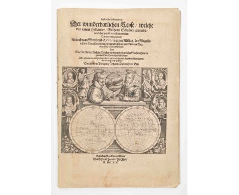
Reyse, welche von einem holländer, Wilhelm Schouten genandt, neulicher Zeit is verrichtet worden (...). Franckfurt am Main, Pauli Jacobi, 1619. 1 text part and 1 plate part. Text: 35 p. Folio. Splendid large engr. title ill. w. double portrait of Magellan and Schouten above a world map, 2 fold. engr. charts outside collation. Plate part: letterpress title-p., 9 plates (incl. the same engr. as on the title of text and 1 chart), loose quires.Professionally and beautifully restored copy, leaf AV w. loss of text, leaf BIV w. repaired tear sl. affecting the text, occas. sm. tears in margins, quires sl. browned, occas. sl. stained. Very rare early ed. Willem Schouten (1577-1625) discovered the Strait of Magellan in 1616, during one of the greatest maritime voyages of all time. The orig. Dutch ed. appeared in 1618. The beautiful ills. were made by members of the De Bry family.

Lot 1093
Continens Marchionatus S. Rom. Impery, Bergozomanum, Comitatus Hoochstr. (...) Baroniam Bredanam (...). Amst., H. Hondius, ca. 1630. 47 x 55 cm. In passe-partout.(2) A 2nd almost identical map. Ibid., idem. Differently col. w. small repairs on sides. (3) A 3rd identical map. Ibid., idem. Backed w. Japanese paper. Sold w.a.f., not subject to return. (total 3)

Lot 412
Princen van Orangien, Haer Leven en Bedrijf, of 't begin en voortgang der Nederlandsche Oorlogen. Vervatende een waerachtigh verhael aller Belegheringhen ende Victorien. Amst., Jan Jansz., 1651. 2 parts in 1 vol. (2),104; (2),419,(3) p. Blindst. vellum w. manuscript title on spine, frontisp. with title, title-p. with sm. vignette, 2 portraits by Broer Jansz after Crispiaen vanden Queboren, an armorial print, and 45 double-p. copper engr., incl. a general map of the Netherlands by Petrus Kaerius, a detailed map of eastern Brabant (Heyr-tocht in Brabant), and an engr. of the funeral procession for Maurice at Delft with the caption listing most of the Dutch nobles by name.Occas. mild foxing, some mistakes in pagination, otherwise a fine copy.

Lot 411
des sieges, batailles, rencontres & autres choses advenues durant les guerres des Pays bas, sous le commandement des Hauts & Puissants Seigneurs les Estats Generaux des Provinces Unies; & la conduite des Tresillustres Princes Guillaume Prince d'Orange & Maurice de Nassau son fils. Amst., M. Colin de Thovoyon, 1616. 2 vols. (6),466; (4),493,(6) p. 4to. Engr. title-p. and 280 plates and portraits, incl. 1 map and 1 double-p. bird's eye view engr., contemp. unif. calf w. gilt spine, obl., both vols. w. former owner's signature dated 1693 on first free endpaper ("monsieur Charles Ballardy adt. en La Cour a Brignolle").Vol. 1 lacks letterpress title w. the privilege verso, vol. 2 lacks leaf Yy2 (p. 351-352, w. text only) and index quire Sss, both vols. sl. waterst., titles and a few other lvs. lacking sm. portions of margins (not affecting text), and a few lvs. cut short in upper margin, occas. staining, sl. spine dam. Important, detailed and finely ill. history about the Eighty Year's War up to 1615 in French transl. (total 2)

Lot 2480
Mounted on 34 lvs., various sizes, 1940. Heavy leather cord bound album. Collection of photos on the destroyed city of Rotterdam during and right after the bombing by the Germans on 14 May 1940, showing areas a.o.: the Rotterdamsch Nieuwsblad building; Station Hofplein; the Coolsingel from all angles incl. the burned out Tivoli building; City Hall; the Coolsingelziekenhuis; the Bijenkorf building destroyed; the Korte Hoogstraat; the Oude Beurs; the Kolk; the Groote Markt; areal photos showing the complete devastation of the old city centre; the burned-out framework of the Groote Kerk and num. other churches; the Nieuwe Haven and Haringvliet; 4 large aerial photos (24 x 18 cm) of several harbour areas and the Plan C building; several of the Zalmhaven, Schiedamschesingel, Witte de Withstraat and the S.S. Statendam during the bombing.Added: 21 loose photogr. picture postcards and sm. photos of the bombing of Rotterdam and a map of Rotterdam w. the bombed area highlighted.
![Comitatus Drentiae D.D. Statoribus Eorumq (...) Reflore scentis Provinciae et Westerwoldiae Domini (...) [Auct.] Cornelis Pyn](https://cdn.globalauctionplatform.com/fefecb27-123d-44f0-a377-af4c009e107c/9a068d4f-4246-4368-b3c9-af4c01241a5d/468x382.jpg)
Lot 1136
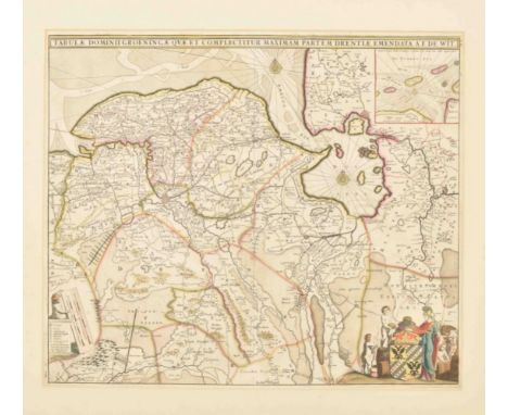
Comitatus Drentiae D.D. Statoribus Eorumq (...) Reflore scentis Provinciae et Westerwoldiae Domini (...) [Auct.] Cornelis Pynacker. Amst., Henricus Hondius, 1634. 38.5 x 49.5 cm. Col., floral cartouche w. title and coat of arms, verso German text.(2) Drentia Comitatus Transisulaniae Tabula II. Auct. Cornelis Pynacker, engr. by A. van den Broeck. Amst., J. Janssonius, [1650]. 39 x 53.5 cm. Large cartouche w. title, coat of arms and hunters w. dogs, scales w. a.o. peasants and sheep, verso French text. (3) Manuscript map fortifications of Coeverden. -and 5 smaller maps. Sold as a collection of maps. (total 8)
Lot 1161
cujus caput Sylvaducis. Amst., Publ. Guiljelmum Blaeu, ca. 1635. 43 x 54 cm. Faded col., signed in the plate, in passe-partout, regional map, several cartouches w. title, coat of arms, scales and blank coat of arms on the sides. On sturdy paper, sl. browned.Added: another regional map: Nieuwe verbeterde kaart van het Landt en de Baanderye van Breda. Den Haag, Jacobus van den Kieboom, 1744. 36 x 45 cm. Col., title, scales and legend on top. (total 2)

Lot 1122
inter Flevum et Lavicam, Auctore B. Schotano a Sterringa. Amst., Nicolai Visscher, ca. 1700. 48 x 57 cm. Copper engr. map taken from a Visscher Atlas, lavishly dec. allegorical cartouches w. title and coat of arms, inset w. Frisian islands, verso blank. A few waterst. not affecting the image.(2) Frisia Dominium vernacule Friesland. Amst., Abraham Allard, ca. 1720. 52 x 60 cm. Glued on cardboard. (3) The same but w. different imprint. Amst., Francois Halma and Covens en Zoon, ca. 1730. Mediocre quality. (total 3)

Lot 6018
Rare complete set of the periodical published in conjunction with four different exhibitions by Constant (1920-2005). Newspaper type sheet, 52.5 x 34 cm, folded twice. Includes: No.1 July 1965 published by Stichting Artishock, for New Babylon at the Dominicanerkerk Maastricht. (2) No.2, October 1965, published by Anarchitectura for Constant | schilderijen plastieken New Babylon at Gemeentemuseum The Hague, edited by Victor Nieuwenhuys.(3) No.3 January 1966, published by Anarchitectura for Constant | Bilder, Gouaches und Plastiken at Galerie Rudolf Zwirner in Cologne, Germany. (4) No.4 1966, published by A. Spin & Zoon for Constant’s exhibition at the Dutch pavilion of the 23th Venice Biennale. Features 8 pages including a double spread colour printed map. Edited by R.W.D. Oxenaar et al. No.2 features moderate toning and spotting, other copies are very good to mint.

Lot 1112
50 x 73 cm. Double folio map on silk, glued on cardboard, of the border regions of Germany and the Netherlands between the Meuse and the Rhine, outline col., allegorical cartouche w. title.(2) Tabula Ducatus Limburch et Comitatus Valckenburch. F. de Wit. 47.5 x 56 cm. Signed in the plate, washed and restored w. Japanese paper. (3) and (4) Identical maps of the Drie Landen van Overmaaze. Amst., Isaak Tirion, ca. 1750. 28 x 33 cm. Fold. (5) and (6) Identical maps of "les environs de Ruremonde, Venlo, Gueldres, Wezel, Duzeldorf". Ca. 1780. 32 x 40.5 cm. -and 5 more 17th cent. fortification lvs. and 5 other 19th cent. maps. Sold w.a.f. (total 16)

Lot 953
P.J. Mendel and H. Reding. Album voor de Aardrijkskunde. Atlas van het Koningrijk der Nederlanden en de Overzeesche Bezittingen. Atlas van het Koningrijk Belgie. 's Gravenhage, A.P. van Langenhuysen, 1841-1843. 2 vols. Obl. folio. 1st vol. w. lithogr. frontisp., hand-col. map of the Netherlands, full-p. general map of the East and West Indian colonies, all hand-col., 13 full-p. lithogr. plates w. 4 views each. 2nd vol. w. general map of Belgium, 9 maps of the Belgian provinces, all hand-col., full-p. lithogr. plate w. 2 portraits, 9 full-p. lithogr. plates w. 4 views each.Lacking 1 plate w. views of Zuid-Holland, bindings sl. worn, sl. foxing. Fine copy of these 2 Dutch atlases, rare to be sold together. (total 2)

Lot 1149
Batavae et Hispanicae in Tetrarchias Noviomagi, Arnhemii, Ruremondae & Zutphaniae Comitatus. Amst., Carolus Allard, 1705. 60 x 50 cm. Large allegorical cartouche w. title, coat of arms and scales, verso blank.(2) Ducatus Geldriae Nova Tabula in Tetrarchias (...). Amst. Joachim Ottens, ca. 1710. 60 x 50 cm. Faded col., verso blank. Added: 2 German maps. Both Augsburg, ca. 1740. 58 x 50 cm. Same map image but different cartouche, faded col., by T.C. Lotter and M. Seutter, verso blank. Sold as a collection of maps w.a.f. (total 4)

Lot 1135
communi nomine vulgo Hollandia nuncupata Continens Statum potentissimae Batavorum Reipublicae seu Provincias VII Foederatas. Nuernberg, J.B. Homann, 1703. 49 x 57 cm. Col. Homann's map of the Low Countries, w. large inset maps of the Northeastern US (from the Chesapeake to Massachusetts) and Southeast Asia, vignette views of New Amsterdam (New York City) and Batavia. One of Homann's earliest maps and the only Homann map to incl. a view of New York City. Large allegorical cartouche w. title. Minor discol. at centerfold.(2) Belgii Pars Septentrionalis communi nomine vulgo Hollandia nuncupata Continens Statum potentissimae Batavorum Reipublicae seu Provincias VII Foederatas. Amst., Petrus Schenk, 1720. 50 x 59 cm. Col. The same map w. both insets. Large cartouche w. coat of arms of the 7 Provinces. Professionally repaired. Sold w.a.f. (total 2)

Lot 1111
ende Belegheringhe van Schenkenschans, 1635-36, J. Blaeu. Amst., 1650. 47 x 57 cm. Detailed map of the siege of Schenkenschanz. The map shows the siege and capture of Schenckenschans, located between the rivers Rhine and Waal, by a Dutch army under Frederick Henry (Frederik Hendrik), 1635-1636. W. faults along the middle fold.(2) Assedio di Schenckenschans fatto del Principe d'Oranges. G.G. Priorato. 39 x 54 cm. Fold., no margins. (3) Fortification Schenckenschans. J. Blaeu. Col. (4) F. de Wit. The same, uncol. (5) and (6) Double folio views from Schenckenschans, Tolhuys, Huys te Hal, Griethiusen and Christina oft nieu Schenckenschans. Added: 2 very detailed maps: (7) Kaart van het Pannerdens Kanaal. "Pannerdensche Canal". Gebied rond het Pannerdensch Kanaal. In Rheinlaendischen Ruthen by Beijerink and Klinkenberg, tab XXIII. Ca. 1792. 41 x 65 cm. (8) Kaart van de Rijn bij de Bijland. Rijn met "Bijlandschen Durchstich" by Beijerink, tab XXII. Ca. 1820. 38 x 65 cm. (total 8)
Lot 947
benevens derzelver treurige gevolgen zo buiten als binnen deze republiek (...). Leiden/Amst., F. de Does/I. de Jongh, 1785. 225 p. Contemp. vellum w. manuscript title on spine, frontisp., large fold. map of the Rhine from its origin to Katwijk, 3 fold. plates (Mülheim, Nijmegen, Zutphen). Sl. foxing, otherwise in excellent condition. (2) F. C. D. Bauer. Berigten en waarnemingen betrekkelijk den watervloed in Gelderland in januarij en februarij 1861. Nijmegen/Arnhem, H. C. A. Thieme and D. A. Thieme, 1863. 150 p. Contemp. hcl. w. marbled paper, 6 fold. plates (3 col. ills., 3 tables), 8 b/w ills. Some wear to binding, sl. foxing, otherwise in fine condition. (total 2)
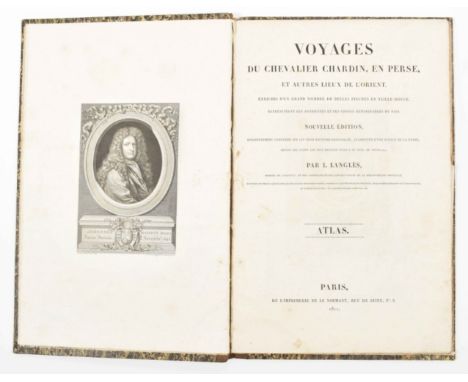
Lot 1058
(...) Nouvelle édition, soigneusement conférée sur les trois éditions originales, augmentée d'un notice de la Perse, depuis les temps le plus regulés jusqu'a ce jour (...). Paris, Le Normant, 1811. Folio. Contemp. hcalf, engr. frontisp. portrait of Chardin, fold. map, 1 other map, 80 ills. on 63 (fold.) platesAtlas only, lacking text vols., upper inner hinge weak, library ticket on top of spine, occas. sl. foxed. Good copy.

Lot 1156
Vulgo Over-IJssel. Amst., C.J. Visscher, 1652. Folio. Large floral cartouche w. title, coat of arms, legend, etc. Sm. margins, professionally restored.(2) Idem. Transisalania Provincia (...). Ibid., F. de Wit, ca. 1700. Folio. Sm. margins. (3) Regional map Twenthe. Gerardus Coeck. Ca. 1700. Folio. Fully col., area around Rijssen, Oldenzaal, Enschede and Bentheim. Rare. Added: 11 smaller maps and views of different sizes, incl. a.o. a town plan and views of Zwolle, ca. 17th cent. (total 14)

Lot 2345
Incl. 12 Map series cards, Puzzle no. 8 and 2 rare die-cut cards. (2) 16 Chromo and advertising cards Chocolade A. Driessen, Rott. (3) 42 Chromo and advertising cards by various Cacao companies a.o.: Grootes; Westzaan; Kraepelien & Holm; Zeist; H.M. Karis Rotterdam; and A. Francken & Co, Koog aan de Zaan.(total 94)
Lot 1144
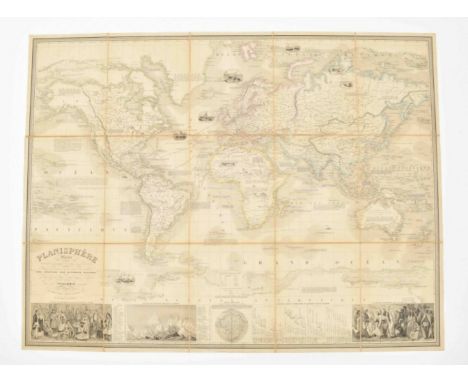
présentant la description géographique des parties connues de la Terre (...) les colonies des diverses nations (...) dressé par Vuillemin. Gravé par Langevin. Paris, Fatout, 1851. Total 83 x 109 cm. Mounted on linen in 15 segments.The world map in Mercator projection, partly col. 3 ills. and "tableau explicatif" at the bottom, a few sm. ills. in vignettes and explanatory texts on map image. Loose as issued in orig. folder (29 x 23 cm) w. dam. spine and titled "Planisphere".
Lot 1175
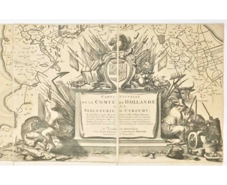
tabula. Carte nouvelle de la Comté de Hollande et de la Seigneurie d'Utrecht. Ou sont exactement marquée toutes les villes, villages, hamaux, les costes de la mer, les bancs, les isles, les lacs, les rivieres, caneaux et generalement tout ce qui s'y trouve, levée sur le lieu en grand point gravée en quarante planches; qu'on peut coller dans une carte de 11. pied de largeur et 6. pied de hauteur. Se vendant a Amsterdam chez Jean Covens et Corneille Mortier. [1726].40 copper engr. sheets (41 x 31 cm) on linen (162 x 299 cm), 2 smaller cartouches w. resp. Latin title and scales and a large cartouche w. the new French title, flags and rural scenery, on top the coat of arms of Holland, in a cardboard folder. This huge wall map was orig. publ. by J.A. Colom, reissued by Frederick de Wit and finally by Covens and Mortier (5th. ed.). Minor changes and a added title in French. A remarkably rare and well preserved wall map of Holland and Utrecht.
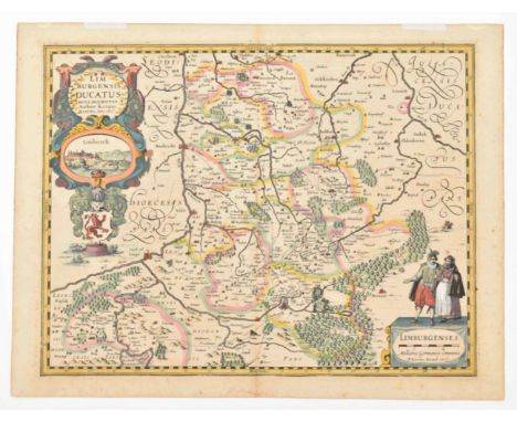
Lot 1140
Amst., Willem and Joan Blaeu, ca. 1650. 39 x 50.5 cm. Col., gilt floral cartouche w. putti and title from a Latin ed. Foxed and waterst., mostly not affecting map image. Worn copy.(2) Limburgi Ducarus et Comitatus Valckenburgi. N. Visscher. Ca. 1680. 47.5 x 57 cm. Col., 2 large allegorical cartouches w. title, coat of arms and scales, verso blank. Sl. browned. (3) Tabula Ducatus Limburch et Com. Valckenburch. Amst., F. de Wit, ca. 1700. 47 x 56 cm. 2 cartouches w. coat of arms and scales, col., verso blank. -and 12 other, smaller maps and plans relating to Limburg. Sold as a collection of maps, not subject to return. (total 15)
Lot 6077
Brussels and Hamburg, Lebeer Hossmann Éditeurs, 1975. Artists' book with numerous collages, assemblages, stamps and illustrations, loosely inserted in a printed portfolio. Signed, dated and numbered in the colophon 32/75, with another signature and unique handwritten comment on the title page reading 'admettre s'etre trompé sur l'art'. Contains 22 leaves and 3 double leaves, 31 x 22 cm, in graphically designed original cardboard box with handwritten title in chalk.This is a copy of the special edition of 75 copies containing the signed title page and four collages marked as originals by stamps (sample of cloth, shard of mirror, folded gauze bandage, section of map). The first edition of the work appeared in 1962/63 in a small print run. Near mint copy.
![17th to 19th cent. (1) Regional map of Amsterdam [Amstelredam] and surroundings. 17th cent. copy of a part of Joost Jansz Bee](https://cdn.globalauctionplatform.com/fefecb27-123d-44f0-a377-af4c009e107c/f2d4e1f5-8650-49bb-ae5a-af4c015439b2/468x382.jpg)
Lot 1128
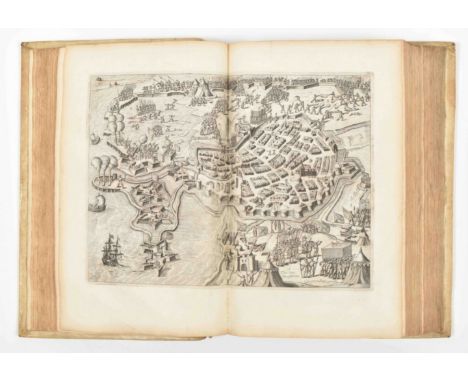
17th to 19th cent. (1) Regional map of Amsterdam [Amstelredam] and surroundings. 17th cent. copy of a part of Joost Jansz Beeldsnijders map: Caerte van Noorthollant (1575). 33.5 x 21.5 cm. Verso blank.(2) Nieuwe Kaart der Provincie van Holland (w. inset Kaartje van De Helder Texel Vlieland en Wierdingen). Amst., Isaak Tirion, ca. 1750. Col., w. folds as issued. Browned on fold. (3-6) Noordhollands Noordelykste gedeelte. Amst., Isaak Tirion, ca. 1750. 33.5 x 36.5 cm. -and 3 sm. 19th cent. maps. Sold as a collection of maps, not subject to return. (total 9)
Lot 1162
Amst., Guiljelmum Blaeuw. ca. 1640. 39 x 50 cm. Col., 2 cartouches w. title, coat of arms and scales, verso Latin text Sl. browned, a brown spot not affecting map image, thin spot along center fold.(2) Tertia pars Brabantiae (...) March. Antverpia. Guiljelmus Blaeu. Ibid., ca. 1650. 42 x 53 cm. 2 cartouches w. title, coat of arms and scales, verso Latin text, signed in the plate, outline col. (total 2)

Lot 2578
Algemeene Landsdrukkerij, 1877. Waterstaat, Algemeene Dienst, the Hague, 1877. 43, 4 pp., 6 fold-out charts and a fold-out map. Spine rest. With (2) Verslag over den Stormvloeed van 14/15 October 1881. (3) [idem] 22/23 December 1894. (4) 12/13 Maart 1906. (5) 13/14 Januari 1916 (incl. X appendixes and the Watersnood en Stormrampen, 1916 Het Leven magazine issue. (6) Verslag van het Voorgevallene tijdens het Hooge opperwater op de Nederlandsche rivieren in den winter van 1925 op 1926. (7) Verslag van het voorgevallene op de Nederlandsche riverieren in den winter van 1916 op 1917.*Ex library 2e Kamer der Staten-Generaal.(total 7)
Lot 387
beginnende mette opdrachte der selver landen, gedaen by Keyser Karel de V aen zijnen zoon Koninck Philippus van Spangien, tot de droevige doot van zijn Excell. Willem Prince van Orangien. Leiden/Amst., Govert Basson/Michiel Colijn, 1621-(1630). 5 parts in 6 vols. Folio. 3 vols. with engr. title-p., title vol. 4 with large vignette, full-p. map, 150 half-p. engr., 22 portraits of which 2 are full-p., 2 woodcuts in the text, uniform blind-tooled vellum, ribbed spines with titles and vol. nos. in ink.Vol. 3, 4 and 5 with contemp. owner's mark in ink, stamps on front endpapers and a few half titles. Incomplete set, 14 fol. w. engr. and portraits cut out, a few w. inner margin cut through surrounding lvs., occas. incorrect pagination, a few engr. views pasted over the orig, full-p. portrait of the author has loose leaf w. text pasted on recto of leaf, some waterst., bindings sl. worn/discol. (total 6)

Lot 1108
Galliae Belgicae dictae continentis invictissimi Hispaniarum Regis ditiones ac provincias (...) descriptio elaborata per Mathiam Zinck Noricum. Antwerp, Gerard de Jode, 1578. Folio leaf from the Speculum Orbis Terrarum, Belgicae Tabula leaf XXXVII. Cartouche w. title, verso Latin text.Leaf not professionally restored, foxed, browned, middle fold w. repaired tear (10 cm), wrinkled, some other repaired tears, sm. loss on map image, thin spots. Overall a shabby copy of this rare map. Ref.: Koeman/VanderKrogt. Vol IIIA, p. 257-260

Lot 1170
van de Zeven Vereenigde Nederlandsche Provintien (...). Amst., 1773. 8vo. 156,(4) p. Hleather w. boards, spine w. title in red and gilt, endpapers, engr. title w. coat of arms, complete w. 53 engr. maps, plans, title, distance tables and map w. flags, maps col.Loosely inserted into vol.: ills. plan of Hoorn w. most important buildings. Boards worn.
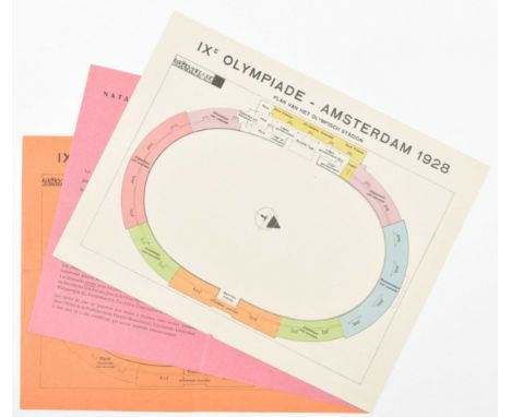
Lot 2431
(1) Fold-out informational leaflet on the Soccer and Hockey events and a view of the Olympic stadium. (2) Orange price leaflet on the events of athletics, cycling, gymnastics and horseback riding. On verso a map of the Olympic stadium and the prices on the opening day. (3) French info leaflet on the swimming and water polo events. (total 3)

Lot 956
Haarlem, A. Loosjes, 1805. VIII,(2),175 p. Modern hleather, contemp. handcol. engr. title-p., large fold. engr. map, contemp. handcol. fold. engr. view by F.A. Milatz showing the start of building activities for the inner sluice at Katwijk, 1 other col. plate, incl. map "Kaart van het Katwijksche kanaal", approx. 22 x 37 cm. Foxed (especially at the beginning and end), hinges splitting. A good, untrimmed copy. Landwehr, Dutch Books w. Col. Plates 354.

Lot 1076
du nouveau continent, fait en 1799, 1800, 1801, 1802, 1803 et 1804. Paris, Librairie greque-latine-allemande, 1816-1817. 4 vols. (of 13). Gilt leather w. marbled paper pastedowns and flylvs., w. 1 fold. engr. map. Incomplete set, lacking vols. 5-13 and atlas, sl. wear to bindings and sl. foxing, otherwise in excellent condition. (total 4)

Lot 1134
Provinciarum Typus. Arnhem, J. Janssonius, 1614. 25 x 32 cm. Verso German text. Map from Emanuel van Meteren's Eigentliche und volkomene Historische Beschreibung, and the same plate was used in Guicciardini's description of the Low Countries, starting in 1625.(2) Carte de Hollande. Paris, Christophe Tassin/Melchior Tavernier, 1637. 37.5 x 52.5 cm. Col. Rare. (3) 17 Neederlantse Proventie met de aengrensende landen (...). Amst., Marcus Doornick, 1675. 24 x 36 cm. (4) Belgii Foederati Provinciae VII. Nurnberg, Christoph Weigel. 28 x 35 cm. Col. (5) The Seven United Provinces. London, Robert Sayer, 1788. 48 x 58 cm. Col. -and 4 other 19th cent. maps of the Netherlands. Sold as a collection of maps w.a.f. (total 9)

Lot 1124
18th to 20th cent. (1-4) Maps by B. Schotanus a Sterringa. Leeuwarden, F. Halma, 1718. Incl. 2 copper engr. w. Lemsterland, Baarderadeel, Aengwerden, 1 col.(5-8) 4 large Eekhoff lithogr. maps. Ca. 1850. Incl.: Dantumadeel (58 x 65 cm); Baarderadeel (58 x 63 cm); Gaasterland (61 x 80 cm); Stellingwerf; and Oosteinde (66 x 93 cm). (9) Map Grieteny Leeuwarderadeel. Leeuwarden, L. Schierbeek, 1838. 34 x 45 cm. Lithogr. (10) Map Provincie Vriesland w. "Doorbraken en overstroomde gedeelten (...) 4 en 5 February 1825". W. folds. (11) Nieuwe kaart van de Provincie Friesland. Leeuwarden, Eekhoff, 1892. Col. w. folds. -and 12 other maps. Added: allegorical title leaf from the Halma atlas, 1718; and 3 lvs. w. coats of arms from the same. Sold as a collection of maps w.a.f. (total 26)
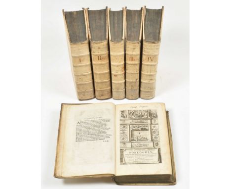
Lot 370
behelzende Saken van staet en oorlogh, voorgevallen in, en omtrent de Vereenigde Nederlanden en door geheel Europa, mitsgaders in meest alle de andere deelen des werelds. Beginnende met het jaar 1669 daar het de Heer Lieuwe van Aitzema heeft gelaten; en eyndigende na het jaar 1679, met het sluyten der Nimeegsche en algemeene vrede. Amst., J. ten Hoorn and J. Bouman, 1685, 2 parts in 1 vol. Paginated in 4 parts: (8),714,(8); (2),376; 216; 55,(9) p. Folio. W. 25 engr. plates: engr. frontisp.; 1 double-p. map of Holland, Utrecht and part of Gelderland; 2 double-p. plates of fortresses; 7 double-p. plates of sieges by C. Decker (siege of Maastricht w. movable part); 11 portraits (some equestrian); 1 double-p. sea battle; 1 double-p. plate of the burial procession of Michiel de Ruyter; and 1 double-p. plate of peace negotiations. Contemp. blindst. full vellum binding, ribbed spine. Occas. foxed, sl. browned, portrait of the "Keurvorst van Brandenburg" erroneously bound in "Tweede stuk, Derde deel" (opposite p. 296). Vellum torn along top of spine and ink indications on spine ("Vervolg") deliberately erased and written over ("vol. II"). Rare. Publ. as finely ill. continuation of Lieuwe van Aitzema. Saken van staet en oorlogh (...). Bound w.: Lieuwe van Aitzema. Saken van staet en oorlogh, in, ende omtrent de Vereenigde Nederlanden, beginnende met het Jaer 1621 (...) ende eyndigende met begin van 't Jaer 1669. The Hague, J. Vely, J. Tongerloo and J. Doll, 1669-1672, 6 parts in 6 volumes. Folio. Each part w. the same engr. frontisp. by H. Bary after V. Schuer, and engr. portrait in the first part. This set lacks vol. 2. Occas. sm. internal and external imperfections. Beautiful example of large 17th cent. bindings. (total 7 vols.)
Lot 6350
Numbered 23/150. Hardcover with 40 silkscreened pp. Artists' book featuring Leonardo da Vinci's name written by the people of his hometown Vinci, on one day in 1973. Moderate soiling on cover, else a fine copy. (2) Plan Cel X document 1001. Breda, self-published, 1967. Cardboard envelope with title label, containing a glossy white portfolio 16.5 x 16.5 cm with fold-out flaps. Inside are two separate sections, one features text and a map regarding 'document 1001', the other has 7 thick white leaves with text about the project Cell X. Intriguing artists' publication. Apart from a small blemish on the cover, a beautiful scarce item. (total 2)

Lot 358
Fils d'un bon laboureur, mis au jour par Mr. *, curé D*. London, n.publ., 1775. 293 p. W. unique large fold. engr. map of France, 4 large fold. tables (2 letterpress and 2 engr.), contemp. hcalf, gilt spine w. mor. letterpiece. Occas. waterst., 1 table loose, upper joint of binding splitting, top of spine and outer corners worn. 1st ed. of this unusual and anonymously published work on financial politics and taxation in 18th cent. France. It was censored in 1776, as it is a fierce diatribe by French farmers against sharecropping and the contemp. system of taxation. Probably published under the patronage of the Ministry (i.e. the Ministry of Turgot and Malesherbes).
-
109182 item(s)/page