We found 109198 price guide item(s) matching your search
There are 109198 lots that match your search criteria. Subscribe now to get instant access to the full price guide service.
Click here to subscribe- List
- Grid
-
109198 item(s)/page


Lot 24
WILLIAM KENTRIDGE (B. 1955)Office Love 2001 signed with the artist's signature woven into the reverse; signed, titled, dated 2003, numbered 3/3 and variously inscribed on a label affixed to the reversemohair, acrylic and polyester tapestry341 by 451.6 cm. 134 1/4 by 177 13/16 in. This work was executed in collaboration with Marguerite Stephens in 2003, and is number 3 from an edition of 3 and 2 APs.Footnotes:ProvenanceAnnandale Galleries, SydneyAcquired directly from the above by the present owner in 2004ExhibitedSydney, Annandale Galleries, William Kentridge: Learning The Flute / Automatic Writing, 2004, illustrated on the cover in colourSydney, S.H. Ervin Gallery, 2004: The Year in Art, 2004 Philadelphia, Philadelphia Museum of Art, William Kentridge Tapestries, 2007-2008, p. 65, no. 17, another example exhibited and illustrated in colourSydney, University of Technology Sydney, 2010-2015, work on loan to the University Another example of this edition is held in the permanent collection of the Philadelphia Museum of Art, Philadelphia.Incisively political and yet profoundly poetic, Office Love belongs to a series of tapestries which William Kentridge began in 2001. This present work is from an edition of three that were executed between 2001 and 2005; the first edition of which is held in the permanent collection of the prominent Philadelphia Museum of Art. The monumental scale and intricate execution of this present work, along with the foundations of cultural and historic sensibility, sets Kentridge apart as an artist who has achieved an extraordinary, compelling contribution to the disciplines of 21st century art. Office Love illustrates an intricate map of Johannesburg with almost life size silhouettes dramatically set against the cartographical formality of the chart. The duality of his composition is arresting; the darkness of his silhouettes, or protagonists, as they so boldly encompass the composition, rest atop the delicate pastel threads delicately woven to construct a map of the city, in an almost collaged fashion. The silhouettes depict a stocky businessman with a typewriter for a head, who purposefully approaches three pieces of what one might decipher as 'feminine' office furniture, the largest of which is a transcriber's table. Interestingly, typewriters started to become standardised in the 1890s, shortly after the years in which Johannesburg was founded and developed as a city. It might be considered that everyday objects such as typewriters recall an early 20th-century colonial world as perceived by the artist that would be apparent to a child growing up in the 50s and 60s. The title Office Love contributes to the assertion of male and female receptivity and possibly contains a more profound meaning; perhaps the depiction of the stocky male advancing is sexual tension or perhaps it is simply progress in today's age. Born in Johannesburg in 1955, William Kentridge has become one of the most highly regarded and sought after living contemporary artists. He has produced a searing interdisciplinary body of work ranging from drawing, film, animation, theatre, sculpture, tapestry and even opera, that explores themes of colonial oppression and social conflict, loss and reconciliation, alongside the transient nature of both personal and cultural memory. He seeks to transmute sobering political events into powerful poetic allegories that resonate profoundly, still to this present day. Setting his oeuvre in context, Kentridge was the son of prominent anti-apartheid lawyers; Sir Sydney Kentridge and Felicia Geffen. His father famously defended Nelson Mandela during the Treason Trials of 1956 – 1961, and his mother was a highly respected human rights advocate who set up an organisation to provide free legal support to marginalised members of South African society, that is still in service today. This political background and family lineage proved vital to shaping Kentridge's artistic career. Upon graduating from the prestigious University of Witwatersrand with a bachelor's degree in politics and African studies, Kentridge enrolled at the Johannesburg Art Foundation, where he studied Fine Arts. His interest in African history and politics remained with him and influenced his work. Due to his parents' involvement in South African politics, Kentridge grew up acutely aware of the injustices in the country, and art became a form of expression for him. Reputed perhaps more widely are his compelling animations that reveal the process of their own creation by showing how individual frames have been drawn, adapted, erased, and otherwise transformed from one image to the next; but William Kentridge introduced the medium of tapestry into his repertoire as another way to tell difficult and harrowing stories akin to his native homeland and the period in which he grew up in. Like his animations, Kentridge's tapestries are also developed from his drawings, the first media his artistic practise evolved from. These preparatory collaged drawings conjure shadowy figures from ripped construction paper which he then collaged onto the web-like background of nineteenth-century atlas maps of Europe and Johannesburg. He began making tapestries in collaboration with the Stephens Tapestry Studio, run by the mother and daughter team of Marguerite Stephens and Tina Weavind, whom he would collaborate with for 24 years. The tapestries are woven from mohair harvested from Angora goats farmed in the Eastern Cape, South Africa, and in Lesotho. The raw mohair was processed and dyed in northern Eswatini before being transferred to the looms at the studio in Diepsloot on the outskirts of Johannesburg. The mapping of geography across many South African cities to produce these tapestries, perhaps speaks to Kentridge's heritage and underlying political preoccupations that resonated in his art. Kentridge's tapestries, which included the first edition of Office Love, were the subject of an important exhibition dedicated solely to this medium organised by the Philadelphia Museum of Art in 2007. Exhibited were eleven works from a multiple of series that showcase similar silhouetted figures set against the backdrop of maps, carrying bundles and belongings as they move forward. The backgrounds of the beautifully woven and embroidered maps, along with the juxtaposition of hulking figures couldn't be more direct. The curator of the exhibition, Carlos Basualdo, explained, 'Kentridge initially thought of his tapestries as 'permanent projections. While they evoke the moving image, his tapestries also illuminate the centrality of drawing in his practice. He uses the language of one medium to talk about another medium, while at the same time dealing with societies that are themselves in a state of transition'. (Carlos Basualdo, William Kentridge Tapestries https://philamuseum.org/calendar/exhibition/notationswilliam-kentridge-tapestries, 19 September 2023). It is plausible to argue that no other South African artist has achieved greater status than William Kentridge. His career has brought him international recognition as one of today's major living artists. This reputation is confirmed by the stature of the global institutions and art museums that have exhibited his work.

Lot 696
THE WHOLE GENUINE WORKS OF VIRGIL, C.1790 leather bound, hardback, by William Henry Melmoth, printed for Alex Hogg, LondonBinding is sound albeit with heavy general wear; frontispiece is a period engraving; title page is period, pasted but with reverse visible, small later pencil annotation lower right; 30 plates present when including frontispiece as well as Map, the Map is a single leaf; advert and subscriber pages present; overall 26.5cm x 22cm

Lot 768
ABRAHAM ORTELIUS, REGNI HISPANIAE POST OMNIUM EDITIONES LOCUPLESSIMA 17TH CENTURY later hand coloured, mounted, framed and under glassIn overall good condition. Some fading to yellow border. Small hairline to section of map. Smallmark to section of water. Card mount with some flaking. Additional images now available.


Lot 68
Taylor and Skinner's Maps of the Roads of Ireland, Surveyed 1777 Taylor (George); Skinner (Andrew) Taylor (George); Skinner (Andrew). Taylor and Skinner's Maps of the Roads of Ireland, Surveyed 1777, Printed for the Authors as the Act directs 14th Nov 1778, 1st edition, London & DublinRebound, missing fold out map at front cover


Lot 170
De Dion Bouton. An album of circa 69 postcards depicting the 1907 Pekin to Paris, featuring De Dion Bouton cars, by J. Bbarreau, a set of 12. Also, another similar incomplete set. Other images include, colour publicity cards, map cards, a set of 12 factory scenes and other cards. Circa 69 cards. AF
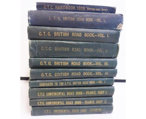
Lot 31
Cyclists' Touring Club Road Books. Nine octavo volumes in limp cloth bindings, all somewhat used, comprising: The British Road Book Volume I, Southern Counties, two copies, 2nd Edition, 1893 (lacking map from front pocket) and 4th Edition, 1897; Volume II, South Midland Counties, Wales & East Anglia, 2nd Edition, 1898 (soiled); Volume III, Northern Counties, 2nd Edition, 1897; Volume IV, Scotland, 1st Edition, 1897; Companion to the British Road Book Volume I, 1st Edition, 1898; Continental Road Books, France Part I, 3rd Edition, 1900 (front endpaper and title page loose, lacking map from front pocket); France Part II, 3rd Edition, 1899; and Germany, 2nd Edition, 1898. Also, The British & Irish Handbook and Guide, 1908. (10)


Lot 1021
VARIOUS BOOKS incl. The Life of William III... 2nd.ed. 1703, London, 8vo cont. fl. cf. fldng. Map (torn, but complete) & 8 engrvd. plts. plus BROWN, T. (MOORE, T.) Intercepted Letters.. 2nd. ed. 1813, London, 8vo orig. bds. fr. bd. det. signed as Thos. Brown, plus BEWICK, T. & J. Select Fables 1820, Newcastle, 8vo cont. hf. cf. fr. bd. det. plus 24 others (27)


Lot 187
NORTHCOTE (James) One Hundred Fables, London: Geo. Lawford 1828, 8vo, large paper copy, portrait frontispiece, vignette title and text engravings, modern full red morocco; ROSCOE (Thomas) Wanderings and Excursions in North Wales, no date circa 1850, 8vo, with 50 engravings, folding map, full red morocco gilt by Webb, Liverpool (2)
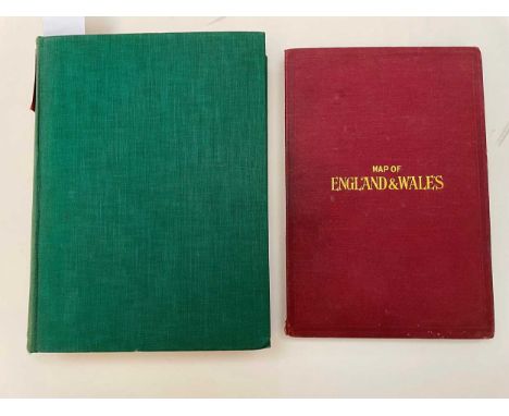
Lot 429
RYMILL (John) Southern Lights, The Official Account of the British Graham Land Expedition, 1934-1937, Chatto and Windus 1938, 1st edition, author's clipped signature to first paste down "With best wishes from John Rymill", plates and maps, very light foxing, original cloth; BACON (G W & Co) Map of England and Wales, 2 folding coloured sheets, 74 x 101cm, and 64 x 101cm, cloth covers

Lot 37
After James Duncan Map of the County of Cambridgeshire, Divided into Hundreds …effected by the Reform Bill, hand coloured engraving 1833, in gilt frame, (ex-Harrods, London); with - Mrs E. Horton B.W.S. (19th/20th Century) Trinity Great Court, Cambridge, signed, watercolour, in original frame

Lot 61
Maps and plans, various Map of East Sussex by B R Davies for J Baxter, 1834, hand coloured with coastal strip views below, 43 x 42cmPlan of Cripplegate Ward, hand coloured engraving, circa 1754, 24 x 38cmFrench route map from Paris to Bordeaux by Michel, hand coloured engraving, 1766, 52 x 24cmDutch map of Ireland by Isaak Tirion, loose uncoloured engraving, 37 x 30cm2 others of small size (6)
Lot 425
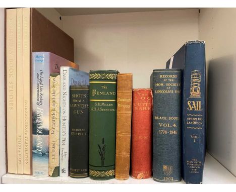
Cambridgeshire history MILLER (S) & S. SKERTCHLY. The Fenland Past and Present, Wisbech 1878, tall 8vo, spotting to title and coloured frontispiece, with folding Fenland map and table, plates, original bright pictorial green cloth gilt; Domesday Book Studies - Cambridgshire, Alecto Historical Editions, London, 1987-90, 3 vols, slip-cased; ATKINSON & CLARK. Cambridge Described and Illustrated, 1897, ex libris Sir James Jeans; EVERITT (N) Shots from a Lawyer's Gun, 5th edition 1910; Pevsner Guide, 1996; others by Enid Porter, L E Harris, John Humphreys, John Steegman, Peter Searby, etc.; a mounted view of Barnwell and Chesterton, coloured engraving circa 1790; with various others, mainly reference, including Records of the Hon. Society of Lincoln's Inn, The Black Books, 1897-1968, vols. 1,2,4,5, cloth; etc


Lot 121
WILLYAMS (Cooper) An Account of the Campaign in the West Indies, in the year 1794. London 1796, 4to, map of Martinique and plan of Fort Bourbon, lightly spotted, 2 aquatints in the text, uncut in original marbled boards, spine worn, front board near detachedbound with 62pp. Appendix and subscribers list but without the other plates. No tissue guards.

Lot 345
Railway and travel ephemera, G.W.R. & other Folio of assorted train and bus posters, railway maps etc. to include an original carriage map ‘Suburban Lines Route Diagram’ dated 1953, station/route plans on waxed linen of Chippenham Union, Uxbridge Union, Brentford Union, Trowbridge, Calne etc., locomotive colour prints after T. Cuneo and others, Main Line Steam Trust Loughborough to Rothley poster (1975), two easel posters displayed at Northolt and Park Royal tube stations one entitled ‘150 Years of London’s Buses’, together with prints of classic locomotives/cars after Giles


Lot 195
Farming and Land related HENRY (David) The Complete English Farmer. London F. Newbery 1771, 8vo, 2 plates, recent full calf; SKEAVINGTON (G) The Modern System of Farriery, no date, 4to, engraved frontis and title, plates, modern half morocco; [HORNE (T H)] The Complete Grazier, 5th edition 1830, 8vo, uncut, boards; SINCLAIR (Sir J) An Account of the Systems of Husbandry... of Scotland, 2 vols., 3rd edition 1814, 8vo, uncut, offsetting on to title, boards with amateur cloth reback; Times Atlas of the World, 11th edition 2005, half bound, slip case; Yale University Press: The Vinland Map and the Tartar Relation, 2 copies 1965 and 1995, dust jackets; 12 others mainly cartography (20)

Lot 101
MORTON (John) The Natural History of Northampton-Shire; with some Account of the Antiquities, 1st edition, London: for R. Knaplock... and R.Wilkin, 1712, folio, large folding engraved map (a little stained and worn), 14 engraved plates, small marginal mark/stain to title and 1st 3 or 4 leaves, pale damp stain tide-mark to top margin throughout, 20th century calf back boards

Lot 186
CARR (Sir John) A Tour Through Holland... in 1806. London 1807, small 4to, 20 tinted sepia aquatints with some offsetting on to text, title and dedication rather foxed and discoloured, map slightly foxed, rebacked speckled calf; SCOTT (John) A Visit to Paris in 1814, 4th edition 1816, 8vo, repaired half calf; ARIOSTO (Ludovico) Opere Varie, 3 vols. Paris 1776, 12mo, engraved titles, calf, joints rubbed (5)

Lot 278
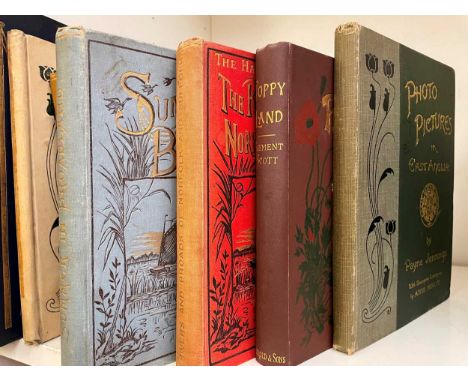
Norfolk Broads region Collection of works, 19th and 20th century, including: COLE (William) A Poetical Sketch of the Norwich and Lowestoft Navigation Works, 1833, 8vo, folding map, 30pp., rebound; JENNINGS (Payne) Sun Pictures of the Norfolk Broads, no date, fine copy in green cloth gilt; with another edition of the same work; Photo Pictures in East Anglia, both in original cloth; EMERSON (P H) Marsh Leaves, 1898, folding map; DOUGHTY (H M) Our Wherry in Wendish Lands, no date, large 8vo, maps and illustrations, original cloth; SCOTT (Clement) Poppy Land 7th edition 1897; DODD (A B) On the Broads, 1896, pictorial cloth; EMERSON (P H) Birds, Beasts and Fishes of the Norfolk Broadland, 1895, cloth; with others by G. Christopher Davies, Ward Lock Guides, sailing interest, wild life and sport (circa 100 vols.)

Lot 64
GREENWOOD (C & J) Map of the County of Lincoln, from an actual survey made in the years 1827 and 1828. London, 1830, hand-coloured engraved sectional map, linen backed, in three sheets, view of the Cathedral to lower left, edged in green silk, some slight typical offsetting, folding into a good morocco book-style slipcase, gilt-tooled and lettered, each section circa 155 x 70cm, overall size 155 x 207cm


Lot 79
B. Baker for George Nicol A Sketch of a Journey from Zhe-Hol in Tartary by land to Pekin and from thence by water to Hang-Tchoo-Foo in China, double page engraved map, 1796, pale water stains, bound with 8 plates only including 2 bird subjects from the folio atlas of Staunton's 'An Authentic Account of an Embassy from the King of Great Britain to the Emperor of China'
Lot 181
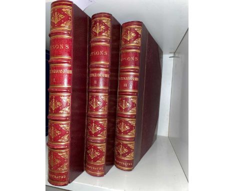
LYSONS (Rev Daniel and Samuel) Magna Britannia, Buckinghamshire, 3 vols., 1813, 4to, with added titles dated 1824, 13 plates including map as called for, and extra-illustrated with 106 portraits and 53 details of architecture etc, with some stubs evident from previously removed plates, some offsetting and light foxing, fine later 19th century dark red half morocco gilt spines, armorial bookplate of Frank Shuttleworth

![BIBLE, [London: Robert Barker 1613, folio] 72 lines, double column in blackletter, Kalendar in red and black, both titles an](https://cdn.globalauctionplatform.com/7b0936b9-2115-44c3-af8a-b08c00c385e1/a167decd-9f89-4f48-9718-b09900b0d8f0/468x382.jpg)
Lot 91
BIBLE, [London: Robert Barker 1613, folio] 72 lines, double column in blackletter, Kalendar in red and black, both titles and final 2 leaves of Revelation supplied in facsimile, without the Speed map, otherwise complete with few repairs and generally close cropped with worming to outer edges and some margins, in 20th century full gilt tooled binding with vellum lettering piece by Bell Golding, with their ticket

Lot 80
John Speed Map of Herefordshire, for Bassett & Chiswell circa 1676, double page engraving with later colour, 40 x 52cm (loose; trimmed close to plate mark); The Entrance to Trinity College, engraving by Joseph Skelton, after J Buckler, 35 x 49cm; 4 hand coloured caricatures after Gillray, Bunbury and Dighton, and other loose prints
Lot 56
A collection of folding touring maps, 20th century mainly Great Britain from circa 1920s, including Bartholomew, Burrow's RAC, Ordnance Survey, and others; also to include Philip's Large Scale Military Map of the Seat of War on the Natal Frontier, 66 x 52cm, and G W Bacon two-section linen backed folding map of England Wales, for The Chart Publishing Co, Oxford; and - Taschen (publisher) Cities Of The World, complete edition of the colour plates of George Braun & Franz Hogenburg, 2008, dust jacket, in card case

Lot 154
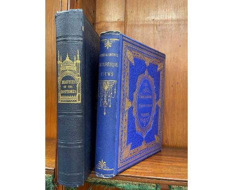
PARDOE (J) Beauties of the Bosphorus, illustrated by W H Bartlett, 1839, 4to, added engraved title, some light spotting, map and 79 plates, all edges gilt, original cloth gilt; TURNER (J M W ) & T GIRTIN. Picturesque Views of English, Scotch and Welsh Scenery, 1873, 4to, portrait frontis and 30 plates, bright cloth gilt (2)
Lot 257
Country pursuits and natural history ANDERSSON (Charles J) The Okavango River: a River of Travel, Exploration, and Adventure, 1861, 8vo, frontispiece and portrait to title, 15 plates, light spotting to first leaves, half calf, tears to spine; TREGELLAS W H) Tourists' Guide to Cornwall, 5th edition 1887, 12mo, folding coloured map by Stanford, cloth; BUCKLEY (A B) Life and Her Children, 1922; Winners in Life's Race 1923, both in cloth gilt; SWALES (F) Driving as I found it, 1891, 8vo; various others, mainly later 19th century

Lot 171
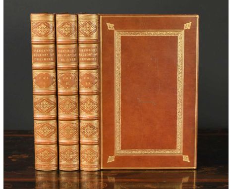
ORMEROD (George) The History of the County Palatine and City of Chester, 1st edition in 3 vols. 1819, folio, portrait frontis, hand-coloured engraved double-page map, 46 engraved plates and plans of which 3 hand-coloured, text illustrations including many hand-coloured shields and crests, some foxing and offsetting to plates, in fine brown morocco gilt by Charles Lewis with his binder's ticket to vol. I, spines gilt in compartments, all edges giltvol. 3 has a scratch to the cover, now polished but still visible. Otherwise a handsome set.

Lot 59
Huntingdonshire county maps John Speed, Huntington Both Shire and Shire Towne with the Ancient Citie Ely Described, sold by Henry Overton, hand coloured engraving circa 1713, 39 x 51cmC & J Greenwood, Map of the County of Huntingdon, 1830, double page engraving, hand coloured, 63 x 76cm (sheet)J. Cary, A Map of Huntingdonshire for the best Authorities, 1805, engraving, 52 x 40cm (3)

Lot 291
CHURCHILL (Winston S) Colour photograph reprint of Churchill seated in the No.10 Annexe Map Room 1945, clipped ink signature to a card mounted below, framed size 35 x 37cmWe believe this is genuine as it belonged to the collection of a Cambridge academic College fellow. I attach a photo of the reverse to show the uneven clipped paper for the signature slip.

Lot 71
Herman Moll A New Map of Great Britain, engraving with outline colour, 1717 or later, 102 x 62cm (visible)general age toning to paper as a whole; a couple of pale stain patches to right side of centre fold and upper left islands; no visible major faults or problems; presumable not stuck down as there is surface undulation and the fold creases show. Colouring has slightly faded. Modern gilt frame.


Lot 180
LYSONS (Rev Daniel and Samuel) Magna Britannia Vol.II Part I Cambridgeshire, 1808, 4to, 4 vols., with added titles dated 1824, 33 plates including map as called for, and extra-illustrated with 202 portraits and 54 details of architecture etc, with some stubs evident from previously removed plates, fine later 19th century dark red half morocco gilt spines, armorial bookplate of Frank Shuttleworth

Lot 41
A collection of framed prints various subjects, including map of North America by Thomas Conder, 'North America Agreeable to the Most Approved Maps and Charts', engraved for Millar's .. System of Geography, last quarter 18th century, hand-coloured engraving, framed, 34cm x 39cm; the other prints mainly 19th century small size views including Scotland (15)


Lot 3231
Benelux.: A new map of the United Netherlands, comprehending also the northern frontier of France and the country southward to Paris, on which are delineated the cities, towns, fortresses and principal villageswith their distance from each other as also from Paris, the post roads, course of the rivers, canals etc., drawn from the latest surveys. Grenzkolor. Stahlst.-Karte bei J. Cary, London 1828. In 40 Segmenten auf Lwd. aufkasch. u. mehrf. gefalt., ca. 110 x 110 cm. - Großformatige Karte der Vereinigten Niederlanden und Umgebung nach dem Wiener Kongreß. D

Lot 103
Full title: Lu Anshi (China, active 17/18th C.): A map of the unified China under the Qing, black and red ink on silk, dated 1722Description:Dim.: 200,5 x 104 cm (outer dimension)Dim.: 178,5 x 101 cm (inner dimension) Ref.: Library of Congress, no. G7820 1722, for a woodblock on paper version (direct link available on rm-auctions.com), also available online at the Digital Atlas project from the Academia Sinica in Taipei (direct link available on rm-auctions.com).Condition:The absence of a condition report does not imply that a lot is in perfect condition.Condition reports are provided on request. They will be made available, together with additional images, on our website at www.rm-auctions.com. Condition reports are given as a service, we can not be held liable for errors in such a report. The full list of condition reports for this sale is available on the following URL: https://www.rm-auctions.com/en/condition-report/75Further questions are always welcome at info@rm-auctions.com

Lot 1197
A late 20th/early 21stC Afghan rug, decorated with map of the country, armoured vehicles, guns, names, etc., in multiple colours on a cream ground with one wide and one narrow border, 94cm high, 78cm wide, and another similar example titled Made in Afghanistan MT, 58cm x 98cm. (2) Both of these rugs were made in Afghanistan during the occupation by the Soviet Union in the late 20th/early 21st century.
Lot 179
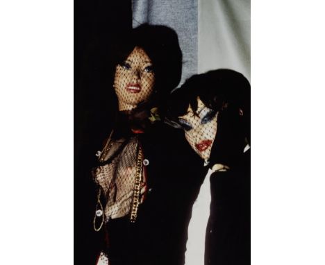
Pierre Molinier (1900-1976)Important ensemble de documentation sur Pierre Molinier. Photographies faites par Françoise Molinier dans l'atelier de la rue des Faussets à Bordeaux le lendemain du suicide de son père, dont 1 photomontage, essai au tir, carte de la Fédération Française de Tir, St Gervais 1940, sur la plage, escapade à Bourg-de-Gironde avec Claire et Alain Donzel, portraits avec la poupée en couleur, la porte de l'atelier portant la mention 'Décédé 19 ½. Pour les clefs s'adresser ...'.49 tirages d'époque.Important set of documentation on Pierre Molinier: photographs taken by Françoise Molinier in the workshop on the rue des Faussets in Bordeaux the day after her father's suicide, including 1 photomontage, shooting test, map of the French Shooting Federation, St Gervais 1940, on the beach, getaway to Bourg-de-Gironde with Claire and Alain Donzel, portraits with the doll in color, the door of the workshop marked 'Deceased 19 ½. For the keys, please contact ...'.49 vintage prints.Divers formats.Footnotes:ProvenanceCollection particulière, FranceThis lot is subject to the following lot symbols: ARAR Goods subject to Artists Resale Right Additional Premium.For further information on this lot please visit Bonhams.com
-
109198 item(s)/page