We found 109182 price guide item(s) matching your search

Refine your search

Year

Filter by Price Range
  • List
  • Grid
  • 109182 item(s)
    /page

Lot 691

Africae Pars Meridional . This handsome miniature map of southern Africa includes part of Madagascar. There is a significant amount of detail along the coasts and in the interior, representing the geographical knowledge of the early 17th century. A sailing ship and strapwork cartouche adorn the map. Latin text on verso. Attractive color with light toning. 5.3"" W x 3.8"" H . Hondius/Bertius, 1618

Lot 692

Pays, et Coste des Caffres: Empires du Monomotapa Monoemugi, &c. Tires de Sanut de Marmol &c. This charming map of the southern part of Africa is fully engraved with mountains, several large rivers, and lakes. The kingdom of Monomotapa covers most of the interior, and a city of the same name sits on the bank of the Spiritus River. Rivers flowing from the Mountains of the Moon (Montagnes de la Lune) feed an unnamed lake at top that appears to be the mythical Lake Zaire. The coast is dense with place names. . A nice impression remargined on all sides with heavy old paper, with the map separating from the old paper at right. There are small damp stains in the new margins at top left and top right. 11.3"" W x 8"" H . Sanson, Nicolas . 1656

Lot 693

A Mapp of the Cape of Goodhope with Its True Situation . A striking map of the Cape of Good Hope showing an inventive inset of Table Bay at the lower left. The interior of the map is filled with elephants, a rhinoceros, lion, ostriches, snakes, and several other species. A road stretches from Table Bay to the interior. A dotted line between Table Bay and False Bay represents a proposed canal that was not undertaken, and a notation of Very Good Grounds refers to the land granted to the first free burgher on the Cape. The sea is filled with ships, and a compass rose orients north to the right of the map. The title is on a hide held by a group of natives while a lion stalks the foreground. The scale of miles cartouche is attended by a Dutchman and a young African with surveying equipment. A crisp impression on watermarked paper with some chips and edge tears in the blank margins, well away from image. 13.8"" W x 11"" H . Nieuhoff, Johann . 1703

Lot 694

Utriusque Nili Albi et Atri Fons et Origo ex Veris Relationibus Geograhice Exhibetur . This decorative map of central and southern Africa and Madagascar is full of the spurious geography of the period with large lakes, rivers and mountains. The Nile is prominently featured with its twin tributaries coming out of Lake Zaire and Lake Zaflan to the east. The decorative title cartouche continues the theme with two river gods (represented by a Nigerian and an Egyptian) symbolizing the Niger and Nile Rivers, with crocodiles emerging from the waters. The map is further embellished with sailing ships and sea monsters. A sharp impression with attractive color. 13.6"" W x 9.1"" H . Scherer, Heinrich . 1710

Lot 695

[Lot of 2] Carte du Canal de Mosambique, Contenant l`Isle de Madagascar... [and] Cape Colony . A. Carte du Canal de Mosambique, Contenant l`Isle de Madagascar avec les Cotes d`Afrique, Depuis le Cap de Bonne Esperance, Jusqu`a Melinde, by Rigobert Bonne, circa 1760 (12.6 x 8.4""). This chart delineates the southern and southeastern portions of Africa, extending along the east coast nearly to the Equator. A large untitled inset details the region from S. Helens Baay to the Cape of Good Hope in the region of today`s Cape Town. There is good detail on Madagascar, which is shown in full, with numerous small islands to the north and east. Trade winds are shown east of Madagascar. Engraved by Andre. Ref: Norwich #173. Condition: A nice impression with attractive color and very light offsetting. (B+) B. Cape Colony, by John Tallis, circa 1850 (12.8 x 9.9""). This detailed map is surrounded in a decorative border including vignettes of the Entrance to the Knysna, Grahams Town, Cape Town, three natives in traditional dress, and a lion. The map is geographically correct for the period with numerous place names. Ref: Norwich #237. Condition: Original outline color with light toning and a few small stains, primarily confined to the bottom blank margin. (B) . See description . See description . . 1760-1850

Lot 696

South Africa . A very large and detailed map of southern Africa below the Tropic of Capricorn. It is filled with detail of the settlements in the region and the realms of the Zulus, Basuto and other native tribes. Notes throughout the map indicate the locations of ruins, pools, salt pans, etc. A lettered key at bottom identifies the ""country ceded to the Kaffirs in 1836,"" the colony of Natal (established in 1843), and lands taken from aboriginal tribes by emigrants. Wyld attributes the information in the map to Major Selwyn, Lieutenant Sherson, Alexander Backhouse, Centlivre Chase, Christopher Moffat, and the M.S. of the Missions Evangelique. This example appears to be the first state; Norwich notes an issue published in 1844 but without the date in the title and showing later colonial boundaries. A nice impression and original color on a sound sheet with light offsetting and scattered foxing. 32.4"" W x 20.1"" H . Wyld, James . 1844

Lot 697

Empire du Monomotapa et Etats Voisins Tire de M Delisle et Autres Auteurs . This map features the Kingdom of Monomotapa roughly in today`s Mozambique. Based on Delisle, it includes the Zambeze River and is bisected by the Tropic of Capricorn. It is filled with notations on gold mines and the supposed sources of rivers. A sharp impression on a watermarked sheet with very faint offsetting. 10.4"" W x 7.9"" H . Bellin, Jacques Nicolas . 1757

Lot 700

[Lot of 2] Carte de l`Oceanie Contenant l`Australie, la Polynesie et les Iles Asiatiques [and] Oceania and Pacific Ocean. From Admiralty Surveys . A. Carte de l`Oceanie Contenant l`Australie, la Polynesie et les Iles Asiatiques, by Alexander Emile & Pierre Lapie, from Atlas Universel, dated 1829, hand color (21.4 x 15.6""). This finely engraved chart covers the islands of the South Pacific from Southeast Asia through Hawaii, and from Australia through the Bass Islands. The map is intensely detailed, showing names of islands and island groups, harbors, channels, and straits. This interesting map was published by Colonel Pierre Lapie (1777-1850) and his son Alexandre Emile, who was the Royal Geographer to the King in Paris. The map was engraved by Lallemand. Lapie`s embossed stamp appears to the left of the title. Condition: A fine impression with original outline color. (A) B. Oceania and Pacific Ocean. From Admiralty Surveys, by Adam and Charles Black, circa 1867, printed color (21.7 x 16.5""). This elegant chart of the Pacific Ocean centers on Hawaii. Nearly all of North America is shown, including the Alaska Peninsula, as is the western part of South America, Australia, the islands of the South Pacific, and part of the Russian Empire. Even pin-sized islands are identified, and there is excellent coastal detail throughout. Drawn by John Bartholomew Jr. and the engraved by John Bartholomew. W.H. McFarlane is credited with the color printing. Ref: Tooley (Australia) p. 22. Condition: Light toning along the centerfold, faint offsetting, and a short centerfold separation at bottom that has been closed on verso with archival tape. There are a few miniscule worm holes that are only just visible when held up to light. (B+) . See description . See description . . 1829-67

Lot 707

Baye de Matavai a Otahiti [on sheet with] Havre d`Ohamaneno a Ulietea [on sheet with] Havre d`Owharre dans l`Isle d`Huaheine [on sheet with] Havre d`Oopoa a Ulietea . Four well engraved charts on one sheet show protected bays on the islands of Otahiti (Tahiti), Ulietea, and d`Huaheine, with numerous soundings, shoals, and anchorages noted. Each features a compass rose and fleur-de-lys. Issued folding on watermarked paper with some faint offsetting, minor toning along one fold, and a small abrasion on the right neatline of the Huahine map. 13.5"" W x 8.6"" H . Cook/Benard, 1780

Lot 710

[Lot of 3] Australia in 1839 [and] New South Wales... [and] Western Australia Containing the Settlements of Swan River and King George`s Sound...[on sheet with] Van-Diemen Island . A. Australia in 1839, dated 1840 (15.6 x 12.6""). Crisply engraved chart with terrific coastal detail with scores of place names and a virtually blank interior. Major discoveries of Cook, Tasman and Flinders are identified. Each colony is named and notes the date of establishment, but none have their boundaries delineated save the ""Colony of South Australia."" Locates the small towns of Sydney, Adelaide, Perth, and Hobart on Tasmania, here Van Diemen Land. The only settlement in the vicinity of today`s Melbourne is Cowie on the west side of Port Phillip near today`s Geelong. Notation at Port Stephens: ""Australian Agricultural Company, Chartered 1824."" The population of the whole region is noted as 141,000. A simple, but elegant map with a keyboard style border. B. New South Wales, dated 1833 (13.5 x 15.6""). An incredibly detailed map of the thriving colony compiled ""From the M.S. maps in the Colonial Office, the Surveys of the Australian Agricultural Company, and the Routes of Allan Cunningham."" The counties are colored in outline and the eastern part of the map is detailed with topographical features and interesting notations. Large inset plan of ""Sydney from the New South Wales Almanack"" marks important buildings including Bathing Houses, Botanic Garden and the Albion Brewery, established in 1827. C. Western Australia Containing the Settlements of Swan River and King George`s Sound... [on sheet with] Van-Diemen Island, dated 1833 (15.6 x 12.3""). Two maps on one sheet. The first covers from Perth and the settlements along the Swan River to St. George`s Sound. The other half covers all of Tasmania and the Bass Strait with interesting detail of the sparsely settled regions. Original outline color with faint toning and soiling along sheet edges. See description . SDUK Society for the Diffusion of Useful Knowledge, 1833-40

Lot 711

Colony of New South Wales . This detailed map of New South Wales is divided into counties and shows good topographical detail and interesting notations including ""impassable range of Rocky Ms."" and ""inundated country covered with reeds."" Features insets of Swan River Settlement and the continent of Australia, noting the ""new settlement of South Australia."" Surrounded by a keyboard style border. Henry Teesdale was a prominent London publisher and founding fellow of the Royal Geographical Society. He produced large-scale maps and charts and a number of fine atlases in the early part of the nineteenth century. He employed the most skilled draftsmen and engravers and his maps are renowned for precise detail and fine coloring. His maps are increasingly scarce on the market. Original color on watermarked paper (J. Whatman 1837) with light toning along the centerfold. 16.2"" W x 13.4"" H . Teesdale, Henry . 1837

Lot 712

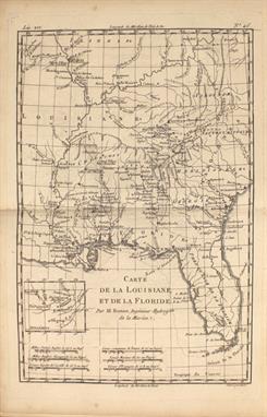
[Lot of 3] Johnson`s Australia and East Indies [and] Oceanica [on sheet with] Australia and New Zealand [and] West Australia [on sheet with] South Australia [and] New Zealand South Island . A. Johnson`s Australia and East Indies, by A.J. Johnson, from New Illustrated Family Atlas of the World, dated 1867, hand color (17.1 x 22.9""). Very striking and colorful map shows Australia divided into seven states/territories including a huge Queensland, New South Wales, Victoria, Van Diemens Land, and West, North, and South Australia. The southeast and southwest regions are more heavily settled than the rest of the continent, where only harbors are located around the coasts, and little or no settlement appears in interior regions. An inset in lower left depicts New Zealand with its three islands named New Ulster, New Munster, and New Leinster. Tables of the counties in Van Diemens Land, South Australia, West Australia, New South Wales, Queensland, and Victoria are also included, keyed to the map.To the north of Australia lie the East Indies drawn in fine detail from the Gulf of Siam, Cambodia, and Cochin China down to Sumatra, Java, Borneo, the Celebes Islands, and the Philippines. The map also shows the Ladrone or Mariana Islands with Guam at their southernmost tip. Also included are tables of counties in the Australian Commonwealth regions of New South Wales, Victoria, Queensland, and Western Australia. The map is surrounded by decorative borders. Ref: Tooley (Australia) p. 102 #754. Condition: Minor offsetting and short centerfold separations at left and right, away from image. There are some short edge tears and light toning, primarily in the blank margins. (B+)B. Oceanica [on sheet with] Australia and New Zealand, by Joseph Hutchins Colton, from Colton`s School Atlas, dated 1860, hand color (9.9 x 12.1""). Two maps on one sheet depicting Australia and New Zealand with an inset chart of the Sandwich Islands (Hawaii). Australia is divided into six provinces with minimal interior detail. The chart includes comparative profile views of the mountains in Australia, New Zealand, and Hawaii. The upper map, titled Oceanica, depicts the entire Pacific Ocean extending from China, Japan, and the United States in the north to Australia, New Zealand, and the southern tip of South America in the south. There is great detail of all the islands in the North and South Pacific. On the verso is a handsome map of Africa with an inset of Liberia. Ref: cf Tooley (Australia) p. 44, #313. Condition: Light foxing and soiling with two damp stains in blank margins, one of which enters map border at left. (B)C. West Australia [on sheet with] South Australia [and] New Zealand South Island, by George F. Cram & Company, from Cram`s Superior Atlas of the World Indexed, circa 1898, printed color (13.5 x 21.1""). This late 19th century sheet features three maps of the region that include major cities, mountains, rivers, lakes, and railways. The maps of West and South Australia are divided into counties, while the New Zealand map is divided into provinces. The New Zealand map includes two insets: Tasmania or Van Diemens Land at top left and Chatham Islands at bottom right. There is a map of northeast Africa on verso. Condition: There is faint scattered foxing and a few light extraneous creases, all on the map of New Zealand. (B+) . See description . See description . . 1860-98

Lot 714

The Islands of New Zealand . Fine 19th century map of the islands with primarily coastal detail. Features interesting notes such as High mountains said to be covered with perpetual snow, Supposed coal fields, and Lookers on appearance of a fine harbour. Engraved by J. and C. Walker. Original outline color with light toning and very minor soiling. 12.3"" W x 15.6"" H . SDUK Society for the Diffusion of Useful Knowledge, 1838

Lot 720

[Lot of 3] Casernes & Navires des Indiens a Moremoreno [and] Manieres Diverses des Indiens sur le Passage des Rivieres... [and] Taille & Habits des Frisons dans l`Amerique Septentrionale... This lot of fine copper engravings comes from La Galerie Agreable du Monde, the monumental Dutch work by one of the most prolific Dutch publishers. The work was issued in 66 parts containing over 3000 maps, town plans, and topographic prints. It was the largest picture and map book ever published. Many of the engravings were printed from multiple plates and enclosed in elaborate, picture-frame borders. The views from La Galerie Agreable du Monde are rarely seen on the market, as only 100 copies of the 66 volumes of this incredible atlas were produced. All edges gilt.A. Casernes & Navires des Indiens a Moremoreno, (12.6 x 8.4""). This vivid engraving shows Chilean natives gathering on a beach. In the water, natives cast out fishing nets from their canoes, while in the background European ships approach. On the beach, families rest in their dugout shelters. Surrounded by an elaborate frame border. Condition: A nice impression with wide margins and minor toning. (A)B. Manieres Diverses des Indiens sur le Passage des Rivieres [on sheet with] Manieres des Indiens sur la Saigne & Guerison des Fievres [and] Cruaute des Espagnols en Punissant leurs Esclaves [and] Peche des Perles a l`Isle S. Marguerite, (16.3 x 13.3""). This fascinating sheet contains four separate engravings, each within a decorative frame border, with an additional frame border surrounding all four engravings. The engravings depict various aspects of life for Native Americans, including their methods of crossing rivers, treatment for fever, cruelty received at the hand of the Spanish, and pearl fishing. Condition: A crisp impression on watermarked paper with minor toning and faint soiling. (B+)C. Taille & Habits des Frisons dans l`Amerique Septentrionale [on sheet with] Walrussen, (15.9 x 9.3""). This sheet features two striking engravings. At left is a scene illustrating Frisian settlers in North America as they use harpoons to hunt ducks. At right is a depiction of a couple of walruses, one an adult, the other a child, on a beach with ships in the background. Both engravings are encased in a large frame border. Condition: A nice impression on watermarked paper with faint toning along the centerfold. (A) . See description . See description . Van der Aa, Pieter . 1729

Lot 721

Les Indiens dans l`Hispagnole Honoroient Anciennement Leurs Idoles . This unusual copper engraving focuses on the rituals of the natives of Hispaniola. A drummer leads a line of people into a place of worship where gifts are offered to an idol with five different animal heads. The engraving is surrounded by an elaborate picture-frame border separate from the plate, as is typical for engravings from La Galerie Agreable du Monde, van der Aa`s magnum opus. The work was issued in 66 parts containing over 3000 maps, town plans, and topographic prints. It was the largest picture and map book ever published. Views from La Galerie Agreable du Monde are rarely seen on the market, as only 100 copies of the 66 volumes of this incredible atlas were produced. All edges gilt. A crisp impression with wide margins and minor toning. 12.6"" W x 8.4"" H . Van der Aa, Pieter . 1729

Lot 724

[Lot of 2] Lions Marins au Port Desiro [and] St. Jago, Ville dans l`Ile de Meme Nom, en Amerique . This lot of fine copper engravings comes from La Galerie Agreable du Monde, the monumental Dutch work by one of the most prolific Dutch publishers. The first engraving depicts a skirmish between European explorers and a few natives at Puerto Deseado in southern Argentina. While the fighting unfolds, several explorers club the sea lions lounging nearby. The second engraving shows ships in the choppy waters off the shore of Santiago de Cuba. Van der Aa`s massive work was issued in 66 parts containing over 3000 maps, town plans, and topographic prints. It was the largest picture and map book ever published. Many of the engravings were printed from multiple plates and enclosed in elaborate, picture-frame borders. The views from La Galerie Agreable du Monde are rarely seen on the market, as only 100 copies of the 66 volumes of this incredible atlas were produced. All edges gilt. Size varies slightly. Both are nice impressions with wide margins. The first sheet is watermarked and has some minor toning. The second has a bit of minor soiling and a centerfold separation at bottom, well away from image. 12.7"" W x 8.4"" H . Van der Aa, Pieter . 1729

Lot 745

[Lot of 2] Cosmographia [with] Charta Cosmographica, cum Ventorum Propria Natura & Operatione . Included with this Latin edition of Apianus` popular Cosmographia is a very interesting world map based on the now lost world map of Gemma Frisius, which is significant in the history of the mapping of America. The continents are broadly based on Mercator`s globe gores of 1541, but North America is shown as a long slender landmass labeled Baccalearium in reference to the cod fishing region off the coasts of New England and Canada. It employs a cordiform projection and depicts a distinct northern passage to Asia over the top of North America. There are few geographical features other than the prominent twin lake sources of the Nile in Africa. The heart-shaped border of the map contains signs of the zodiac within a cloud background filled with mythical figures and wind heads. One of the deities at top sports the design of the Holy Roman Emperor`s double eagle on his breastplate and the three cadaverous wind heads at bottom represent plague-carrying winds of the south. This is an example from the second of three woodblocks, issued with Latin and Dutch text. The world map is not attached to the book, and actually comes from a different example of the Cosmographia, as it is printed on a slightly larger sheet.The Cosmographia of Petrus Apianus was one of the most popular books on cosmography ever published. It covers a multitude of subjects including the climatic zones, the uses of parallels and meridians, the determination of latitude and longitude, map projections, etc. One of the reasons it was enormously popular is the inclusion of volvelles that enabled one to solve practical mathematical problems relating to time telling, the calendar, astronomy and astrology. There are four (of five) of these ingenious paper devices included, and numerous other interesting diagrams and illustrations. The movable parts of the volvelle Aux Solis are missing. In addition to the world map, there is also a small map of Greece, and one of the volvelles is constructed on a map of the northern hemisphere. This edition, corrected and augmented by geographer and mathematician Gemma Frisius, contains Gemma`s important treatise on triangulation, which first appeared in 1533. The treatise was the first instance of triangulation being proposed as a means of locating and mapping places. 8vo, in full vellum covers. The map is a nice impression on watermarked paper with original margins, a tiny centerfold separation in top blank margin, and a few faint spots of foxing. One of the nicer examples we`ve seen, with only a centerfold rather than the typical multi-folded examples found in most Cosmographia. The text is mildly toned, with folio text pages 46-48 missing. The four volvelles are in excellent working condition. The covers and spine are lightly toned and soiled. 6"" W x 8.9"" H . Apianus, Peter Bienewitz . 1564

Lot 746

Atlas de Toutes les Parties Connues du Globe Terrestre, Dresse Pour l`Historie Philosophique & PolitiqueÂ… . This is the atlas volume for Abbe Raynal`s ""L`Histoire Philosophique et Politique des Etablissemens et du Commerce des Europeens dans les Deux Indes"" and is filled with Bonne`s well-drawn maps and charts engraved by Andre. The title page, list of maps, and Analyse Succincet de Cet Atlas are not present but a manuscript title page and list of maps have been included (see images). Map collation appears complete. The map contents include two world maps, Europe, Asia, Africa, ten related to Europe, three related to Africa, two related to India, Arabia, the East Indies, the Moluccas, China, Persia, Philippines, Russia, six related to South America, several Caribbean charts, plus North America and those related: Mexico; le Nouveau Mexique; Terre-Neuve, Acadia...; Occidentale du Canada; Louisiana & Florida; Partie Nord des Etats Unis; and Partie Sud des Etats Unis. In the North America map, the entire western part of the continent is left mostly blank. Indian tribes occupy the edges of the defined territory -- Apaches, Sioux, Outagamis, and Assenipouels. The British Colonies and a few major cities are named along the eastern seaboard and in the Great Lakes region. Alaska is shown as a group of islands, the largest of which is labeled Alaschka. Quarter-calf over marbled boards with gilt tooling and title on spine. The atlas volume did not carry any publication information on the title pages, but was known to be published in 1780. The maps are generally very good to near fine except the following: the world map (B) is somewhat soiled with a small burn mark in the top left corner just touching the neatline; and the maps of the Southeast United States and West Indies at the back of the volume have some small brown stains in the image. The hinges are perished and have been replaced with archival tape, which also serves to hold the manuscript title page and list of maps in place. Covers are bumped and worn with just a few minor cracks along the joint. 8.3"" W x 10.3"" H . Bonne/Raynal, 1780

Lot 747

A New Universal Atlas of the World; Comprising in Twenty Maps, Carefully Prepared, from the Latest Information, and Neatly EngravedÂ… . This is the Morses` significant early American atlas, complete with a double-hemisphere map of the world, North America, the United States, Canada, West Indies, South America, Europe, its various nations, Asia, Africa, Hindoostan, and the Pacific Ocean. The double-page map of the United States, engraved by A. Doggett, is similar to the one engraved by N. & S.S. Jocelyn and published in Morse`s An Atlas of the United States [1823] and New Universal Atlas of the World [1825], which is cited by Wheat. This earlier map is not mentioned. The map features the Oregon country with the overly-long Multnomah (Willamette) River. There is no northern boundary shown, although the map of North America shows the correct boundary to the Pacific. In the west, which is mostly labeled Unexplored Country, a dotted line connects a lake in the vicinity of Salt Lake to the Pacific accompanied by a note, ""Supposed River between the Buenaventara and the Bay of Francisco which will probably be the communication between the Atlantic and the Pacific."" Title, table of contents, and 20 maps. Hardbound in original quarter leather and marbled paper boards. Condition code is for the maps which are generally very good or better with scattered foxing on the world map and a 1"" fold separation on the U.S. map. The rest of the maps have just a rare spot of foxing or toning. Title page and list of maps are foxed and the front endpapers have numerous pencil notations. The hinges are loose with heavy wear and staining to covers and spine. 9.3"" W x 11.3"" H . Morse, Jedidiah & Sydney, 1822

Lot 748

The Cerographic Bible Atlas . Morse & Breese`s North American Atlas and Cerographic Bible Atlas were landmarks in American cartography, being the first atlases to utilize the cerographic printing process (wax engraving), which would revolutionize the map trade later in the 19th century. The maps were first printed in a series of inserts which appeared in the New York Observer and then later as separate atlases. The list of five maps in the atlas include: A. General Map of the Countries Mentioned in the Bible B. Map of the Journeyings of the Israelites in the Desert. Chiefly from the Map of Robinson and Smith C. Map of Palestine from the Latest Authorities Chiefly from the Map of Robinson and Smith D. Plan of Jerusalem from the Map of Robinson and Smith [on sheet with] Environs of Jerusalem from the Map of Robinson and Smith E. Map of the Travels of the Apostles Chiefly from the Map of Dr. Augs. Neander . Maps are very good with a few minor spots and a few small chips and edge tears in the bottom blank margin. Front paper wrapper is partially detached at top. 14.3"" W x 17.5"" H . Morse & Breese, 1846

Lot 750

Colton`s Illustrated Cabinet Atlas and Descriptive Geography . This is a nice and complete example of this increasingly difficult to find atlas. It is filled with some of Colton`s most beautifully engraved maps. Each features the delicate floral-style border not seen in any other atlas produced by the Colton family. The frontispiece is a fine steel engraving showing a beautiful woman with a globe. The maps are by G. Woolworth Colton and the extensive text is by Richard Swainson Fisher. This edition includes 113 colored maps on 47 sheets. There are 18 sheets related to the United States and North America, with the map of the United States featuring early borders and oversized territories. The map Oregon, Washington, California, Utah & New Mexico is after the earlier map of the same area by Mitchell as published by Thomas & Cowperthwaite. To the south of New Mexico Territory is a small Arizona Territory, a precursor to the Confederate Territory of Arizona. Folio, original full leather with maroon embossed boards and gilt titling. Attractive A.E.G. 400 pages, frontispiece, 2 title pages, table of contents, list of maps and plans, text with wood-engraved vignettes, maps, and index. Several of these maps appear in no other publication. The maps are very good to near fine with occasional light scattered foxing. The map of India is moderately toned. The frontispiece is chipped along the top edge of the sheet with a small damp stain along the gutter. The hinges are starting and have been reinforced with hinge tape. Front cover has a small chip in ""Colton"", otherwise light wear with edges bumped. 12.5"" W x 15"" H . Colton, Joseph Hutchins . 1859

Lot 751

Mitchell`s New General Atlas, Containing Maps of the Various Countries of the World, Plans of Cities, etc. Embraced in Forty-Seven Quarto Maps, Forming a Series of Seventy-Six Maps and Plans, Together with Valuable Statistical Tables . This complete example of Mitchell`s world atlas was produced during the first year of the Civil War. It is complete with 77 maps and plans on 48 sheets (inclusive of an unnumbered Plan of New Orleans not in the table of contents), each surrounded by Mitchell`s signature floral border. There are 23 map sheets related to the United States including 31 individual states and territories, regions and city plans. There are two world maps - one hemispheric and the other drawn on Mercator`s Projection.The map of Texas shows county development to 100° longitude with the large regions of El Paso, Presidio and Bexar Territory further west. The Staked Plain is now called Young Territory. The map of the United States depicts the Confederate Territory of Arizona, Nebraska with a long panhandle, and Washington Territory in its inverted ""L"" shape. The Pony Express route is depicted as are numerous exploration routes, important trails including the Santa Fe, the Overland Mail Route to California, wagon roads and early railroads. This 1861 edition did not include a separate map of the southwest, however on the U.S. map the southern tip of Nevada is contained as part of New Mexico Territory, and Utah encroaches a full degree into Nevada. Includes full-page plans of the cities of Boston, New York, Philadelphia, Baltimore, New Orleans and Cincinnati. All maps carry the 1860 copyright date. Hardbound small folio, publisher`s quarter calf with tips over cloth covered boards, stamped title on front cover. Title page, list of maps, and maps and plans are followed by 26 pages of text: List of Post Offices in the United States, Table of Population, Governments. &C., Mountains of the World, and Rivers of the World. Condition code is for the maps which are generally clean and bright with some occasional light soiling or spot of foxing confined to the blank margins. There is a small damp stain in the lower right blank margin of the title page, list of maps, and hemispheric map. The text pages are lightly foxed. Signatures are partially loose, while the covers and spine are rubbed and stained. 13"" W x 16"" H . Mitchell, Samuel Augustus . 1861

Lot 752

Johnson`s New Illustrated (Steel Plate) Family Atlas, with Physical Geography, and with Descriptions Geographical, Statistical, and Historical... This complete atlas contains 66 beautifully rendered, steel engraved maps, including 34 double-page maps. There are several thematic maps and diagrams interspersed throughout the text that display the geology, weather, tides, agriculture, flags and animal kingdoms of the world. This 1864 edition is the last year with steel engraved plates, with many of the maps featuring vignettes, and some retaining the early strap-work style borders. It also has the desirable edition of the New Military Map of the United States which shows all state and territory boundaries rather than the limits of military divisions. And it features the double-page Civil War map Vicinity of Richmond.The Southwest map is the late 1863 - early 1864 edition in this series of maps. Arizona still claims the Southern tip of Nevada and has the county configurations of the old New Mexico Territory, with the addition of Castle Dome and Ewell counties in the south. The Utah/Nevada border is now at 115°. This is a completely new plate with extensive revisions in the watershed and mountain detail and several of the earlier notations removed. But it retains the note in the area of Quartzite, Arizona calling the area ""exceedingly fertile and abundantly timbered and well watered."" The map details the U.S. Mail routes, the Emigrant roads to California, the proposed railroad route through Utah, Nevada and California, and the Pony Express trail. The double-page map of Texas shows county development mostly in eastern Texas and only the three large counties of El Paso, Presidio and Bexar in the west. The panhandle, noted as the Staked Plains (Elevated Table Land, without Wood or Water), includes a large section that is unorganized. There is nice depiction of the wagon roads, many named, with several completed railroads. The inset maps include a `Plan of Sabine Lake,` `Plan of the Northern part of Texas,` and `Plan of Galveston Bay.` The map of the Northwest shows the newly created territory of Idaho. The map of Minnesota shows the newly created region of Dakota with an undefined western boundary.Folio. Hardbound in original quarter leather with tips and green cloth, embossed covers with gilt titles on cover and spine, marbled end papers. The maps are all very good with a few occasional spots of foxing and a damp stain in the bottom right corner that only enters the border of about a quarter of the maps. A few maps have tears or chips in the blank margins that do not enter the map image. The map of the West Indies has some stains in the image. The sheet of tissue that typically protects the frontispiece is missing. The front cover is nearly detached and the back hinge is starting. The covers and spine are stained and show moderate wear. 14.8"" W x 18.8"" H . Johnson & Ward, 1864

Lot 754

Gray`s Atlas of the United States, with General Maps of the World. Accompanied by Descriptions Geographical, Historical, Scientific, and Statistical . This complete atlas contains 52 single-page maps and 12 double-page maps including the uncolored climatological map by Blodget, and a very attractive Mountains & Rivers chart. Contains all states and city plans of Baltimore, Chicago, New York and Washington D.C. This western edition also contains a city plan for Sacramento and New RailRoad and County Map of the States of Oregon, California, Nevada which shows numerous railroads including the Texas and Pacific, Central Pacific, Oregon Central and Northern Pacific. Also includes a business directory for the cities of San Francisco and Chicago. Hardbound in brown cloth with quarter calf and tips, title page, contents, descriptions, maps and index. Condition code is for the map, which are mostly very good to near fine with light toning and a few edge chips confined to the blank margins. Binding is very loose. Spine has nearly perished and covers are stained and chipped. 15.3"" W x 17.8"" H . Gray, O. W. 1873

Lot 755

Mitchell`s New General Atlas, Containing Maps of the Various Countries of the World, Plans of Cities, etc. Embraced in Ninety-Three Quarto Maps... This is a very nice and complete example of this atlas which contains 147 maps and plans, most surrounded by a grapevine border and dated 1880. More than 50 maps are related to the United States with individual states, regions and city plans. There are several double-page maps with a few single-sheet maps printed on the verso. This example includes a charming Map of the Original Thirteen Colonies that has engraved examples of the ""first money coined by the United States."" Other maps of interest include County Map of Arizona and New Mexico, Map of Oregon, Washington, Idaho, and Part of Montana, and a fine maps of California and Texas. Also included is a spectacular double-page plan of Chicago and a foldout map of Africa by John Arrowsmith. Hardbound in original brown cloth with quarter calf spine and tips and gilt title on front. Small folio atlas published in Philadelphia by Bradley & Company. Maps are in very good to near fine condition with pleasant light toning. The map of Mexico has an edge tear at bottom that extends 1"" into the image, the folding map of Africa has two edge tears at left that extend 1"" and 2"" respectively into the image, and the plan of Chicago has centerfold separations at top and bottom that enter 2"" and 5"" into the image respectively. The hinges are starting, and covers and spine rubbed. 12.8"" W x 15.7"" H . Mitchell, Samuel Augustus . 1880

Lot 757

[Lot of 3] Cram`s Unrivaled Family Atlas of the World [and] The National Standard Family and Business Atlas of the World... [and] Cram`s Superior Reference Atlas of Ohio and the World . A. Cram`s Unrivaled Family Atlas of the World, published 1885 (11.8 x 14.0""). This atlas consists of 76 out of 79 wax engraved maps which are tipped-in with fancy borders. The missing maps are Illinois, Michigan and Wisconsin. Charts include Flags of the World, types of the Races of Men, as well as other thematic charts and pages of portraits. This edition was originally published in 1883 with a revised copyright date of September 1885. Title page, contents, list of the population of cities, index, 200 pp. Hardbound in original brown cloth with embossing and gilt titling on the cover. Condition: Covers have separated from text block and pages are loose. (B) B. The National Standard Family and Business Atlas of the World Specially Adapted for Commercial and Library Reference..., published 1899 (11.7 x 14.9""). This complete atlas contains 29 double-page, and 82 single-page cerographic maps of the world and continents. It is nicely illustrated with dozens of wood engraved vignettes, state seals, charts, diagrams and colorful examples of the Flags of the Various Nations and the Arms of Various Nations. The Map of the Polar Regions... shows the more recent expeditions to the North Pole by explorers like McClintock, Berry, Collinson and others stamped in red ink. An interesting double-page map of Newfoundland shows little interior detail, but does include the island`s telegraph lines and stations. The route of the Newfoundland Railroad, featured prominently on this map, runs from Port Aux Basques, eastward to St. Johns. In the back of the atlas is a 20-page chronology of ancient, medieval and modern history, and an exhaustive 105-page index. Published by the Fort Dearborn Publishing Co. Small folio with 420 pages. Hardbound in original green cloth with silver titling on front cover. Condition: Covers are nearly detached. (B+) C. Cram`s Superior Reference Atlas of Ohio and the World, published 1909 (12.0 x 15.0""). This uncommon atlas contains 44 double-page, 22 single-page, and 12 quarter-page cerographic maps of the world and continents. There are seven maps of Ohio depicting the geology, agriculture, mining and industry of the state. The atlas also features detailed plans of Cleveland, Cincinnati, Columbus and Toledo, and a 15-page index of Ohio. Extensively illustrated, this example includes a series of attractive black and white photographs showing scenes of faraway places like Greenland, the Philippines and Europe. The atlas is further illustrated with three pages of presidential portraits, the Flags of the Various Nations and the Arms of Various Nations. An interesting map of the North Polar RegionsÂ… shows the tracks of 20 explorers, including Cook, Peary, Baffin and Hudson. Small folio with 168 pages. Hardbound in original green cloth with decorative silver titling on front. Condition: The covers are stained and nearly detached. Pages 125-126 are missing while pages 129-132 are present but loose, and several pages of illustrations at the back are partially torn. (B) . The maps are in good to very good condition with occasional soiling, pencil marks and edge tears. See description for additional details. See description . Cram, George F. & Company . 1885-1909

Lot 759

[Lot of 3] School Atlas to Cumming`s Ancient and Modern Geography Improved [and] Atlas, Designed to Illustrate the Matle-Brun School Geography... (1833) [and] .... (1837) . A. School Atlas to Cumming`s Ancient and Modern Geography Improved, by George J. Ordway, published 1830 (9.4 x 11.9""). Seven engraved and well colored maps, both single and double page. Includes a double-page world map and singe-page North America. Missing the United States map. This uncommon atlas was published by Collins & Hannay, New York. Condition: The covers and the world map are water stained, the remaining maps have occasional foxing and pencil notations. (B) B. Atlas, Designed to Illustrate the Malte-Brun School Geography..., by Samuel Griswold Goodrich, published 1833 (8.8 x 11.3""). Complete with sixteen full and double-page maps plus five tables. The map of the Untied States has a huge Missouri Territory and an oversized Arkansas Territory with its western boundary extending to Mexico at the edge of the panhandle of Texas. Texas is named. Oregon Territory extends from Mexico northward well into Canada and from the Pacific to the Continental Divide at Missouri Territory. Condition: Minor soiling and occasional spots of foxing in the maps. Covers stained. (B+) C. Atlas, Designed to Illustrate the Malte-Brun School Geography..., by Samuel Griswold Goodrich, published 1837 (8.9 x 11.1""). Includes fifteen of sixteen double-page maps plus five tables (missing the United States map). This geography is identical to the above 1833 version in content and condition. (B+) . All three geographies are disbound and should be considered a collection of loose maps. See description for additional details. Condition codes are for the maps. See description . . 1830-37

Lot 760

[Lot of 2] Colton and Fitch`s Modern School Geography... [and] Mitchell`s School Atlas . A. Colton and Fitch`s Modern School Geography. Illustrated by Forty Maps, and Numerous Engravings, by George Woolworth Colton, published 1863 (8.2 x 9.8""). This Civil War period geography is ""Illustrated by Forty Maps, and Numerous Engravings"" including fine maps of Texas, United States, California, and the Southwest. Pictorial cover showing a teacher instructing her class in geography with a map and large globe. Condition: Text and maps are clean and bright with a little soiling on covers. (A) B. Mitchell`s School Atlas, by S.A. Mitchell, published 1867 (9.5 x 12""). This example of Mitchell`s famous school atlas includes 31 of 34 maps (most with blank versos) along with tables and statistics. Includes nice maps of the United States and California. The missing maps are Texas, Western States and Michigan/Wisconsin. Hardbound with pictorial paper over boards. Published by E.H. Butler & Co. Condition: Disbound and should be considered a collection of loose maps, which are generally very good, but a few with light scattered foxing. Previous owner`s name in pencil on inside blank end paper. (B+) . See description . See description . . 1863-67

Lot 761

Report of the Superintendent of the Coast Survey, Showing The Progress of the Survey During the Year 1853 . This annual report by the Coast Survey is complete and contains fifty-four folding charts and sketches. The surveys covered by this report include the Atlantic, Gulf and California coasts. Important charts include Seacoast of Virginia, Cape Fear River, Galveston Entrance, San Diego Entrance and San Francisco Bay and Vicinity (see images for a complete listing of maps). Complete, 186 pp. Robert Armstrong, Public Printer. Hardbound in original embossed black cloth boards with gilt titles. Maps are good to very good with some occasional toning. Map no. 1 (Nantucket region) has a 7.5"" binding tear and map no. 6 (Long Island region) has a 2.5"" binding tear. Text has light scattered foxing which is more prevalent in the first half of the book. Covers and spine are excellent with only minor wear. 9.5"" W x 11.7"" H . U.S. Coast Survey, 1854

Lot 762

Message from the President of the United States to the Two Houses of Congress ... Part IV... This is the complete volume of illustrations accompanying the reports submitted for the 1st session of the 34th Congress. The 35 illustrations are primarily from the General Land Office (16) and Bureau of Topographical Engineers (13), but also include a few from the Quartermaster General and Secretary of the Navy. Of particular interest in this volume are: Map of a Part of the Territory of Washington to Accompany Report of Surveyor General (19.3 x 14.3""). This uncommon map was executed by James Tilton, Surveyor General, from the Olympia office. This is the first GLO map of Washington Territory, issued just 28 months after its creation. The map shows limited survey progress with modest detail west of the Cascades. In the east, only major rivers are shown. Several forts (Steilacom, Nisqually, Walla Walla, & Townsend) are located and Seattle is labeled Statle. Legend at upper right identifies surveyed lines, surveys under progress, townships subdivided, and proposed surveying for the 1856 & 57 season. Map Showing the Different Routes Travelled over by the Detachments of the Overland Command in the Spring of 1855 from Salt Lake City, Utah to the Bay of San Francisco (18.5 x 22""). This uncommon map accompanied the ""Report of Capt. R. Ingalls on the march of L. Col. Steptoe from Ft. Leavenworth to California"" in 1854 and 1855. Wheat states ""it is a document of first quality.. showing three important routes."" Steptoe was looking for a new and shorter route from the Great Salt Lake to the Pacific Coast. In addition to the route chosen by Steptoe, the routes of two detachments are also traced - one under Capt. Ingalls, the other by Lt. Mowry. The map extends to include all of California and part of Oregon to above the Rogue River. It stretches eastward to name G.S. Lake City, the Mormon capital of Fillmore, Cedar City and Fort Yuma on the Colorado. References: Wheat (TMW) #868; Wagner & Camp #256. Map of Public Surveys in California... (36 x 30""). This large and remarkably detailed map delineates the progress of public surveys throughout the state on a scale of 18 miles per inch. About one-third of the state, in the north and east, remains unsurveyed. Lake Tahoe is shown fairly accurately, but is still called Bigler Lake. Printed on two sheets, joined as issued. Hardbound in original embossed cloth boards with gilt titles on front cover and spine. Overall the maps are in good to very good condition in a few cases with light toning and occasional damp staining mainly along the folds. The map of California has an 8"" binding tear and one tiny area of loss at a fold intersection. The map of Florida has a 12"" binding tear. Title page is toned and damp stained. Covers are stained and rubbed. 8.8"" W x 11.9"" H . U.S. Government, 1856

Lot 763

[Book 1, Volume XII] Reports of Explorations and Surveys, to Ascertain the Most Practicable and Economical Route for a Railroad from the Mississippi River to the Pacific OceanÂ… . This is the complete Book 1 of Volume XII from the 1860 House edition, which is a revised and enlarged version of Stevens` narrative first published in octavo format in 1855. This volume describes Stevens` explorations from St. Paul to Puget Sound and contains his general narrative and final report and a superb collection of lithographs by John Mix Stanley, the expedition artist. Among the important lithographs are those that depict St. Paul, Fort Union, Fort Benton, Blackfeet Indians, Fort Owen, Nez Perces, Mount Rainier, and Cantonment Stevens (Corvallis). Included are lithographs of Hellgate (Missoula before there was a settlement), of the Big Hole Valley in Montana, and of the Great Falls of the Missouri. Volume XII is one of the most richly illustrated volumes in the entire series containing seventy tinted lithographs (one of which is folding), and three folding charts including: Isothermal Chart of the Region...between the Atlantic & Pacific Oceans, the General Rail-road Profile, and the important map from Milk R. to the Crossing of the Columbia R. (60.5 x 23.2""). This remarkable map details the entire 1853-1855 surveys conducted to locate a northern route at the 47th and 49th Parallels. Most of the map covers Montana, with extraordinary detail and excellent relief by hachure, the naming of rivers, numerous routes with dates, and interesting topographical commentary. The map not only shows the main party`s route, but also numerous routes followed by the various parties attached to the command. Joined on two sheets as issued. Tall quarto, 358 pp. with appendix and index. Printed in Washington by Thomas H. Ford. Hardbound, quarter leather and tips over blue marbled boards. Text, plates and maps are very clean and bright - nearly flawless. The Milk River map has a short 1.5"" binding tear. The spine has some minor cracks and the covers show typical wear. 9.5"" W x 11.8"" H . U.S. Railroad Surveys, 1860

Lot 768

[Lot of 3] Maps and Map-Makers [and] Country Life Book of Antique Maps An Introduction to the History of Maps and How to Appreciate Them [and] Antique Maps of Europe, the Americas, West Indies, Australasia, Africa, the Orient . A. Maps and Map-Makers, by R.V. Tooley, published 1970 (7.6 x 10.1""). This is the fourth edition of this standard work for any collector`s library. It provides information on the principal map makers and publishers throughout the history of cartography. 140 pp. with 104 illustrations, many colored. Hardbound in orange cloth with dust jacket. Condition: Contents fine with some minor wear to the book`s edges. There are a some small chips and tears to the lightly soiled dust jacket.B. Country Life Book of Antique Maps An Introduction to the History of Maps and How to Appreciate Them, by Jonathan Potter, published 1989 (8.8 x 12.1""). This reference is a good introduction to collecting antique maps for the newer collector. It is beautifully illustrated, mostly in color. Covering all parts of the world from about 1500 to 1850. Hard bound in cloth with dust jacket. Gilt title at spine. 192pp, including index. Condition: Contents fine with a small amount of wear to cover and dust jacket. There is a stain on the dust jacket at top right on the front cover and some minor soiling. C. Antique Maps of Europe, the Americas, West Indies, Australasia, Africa, the Orient, by Douglas Gohm, published 1972 (9.6 x 12.9""). This fine overview of antique maps features brief biographies of major cartographers. It covers a very wide selections of maps from the 15th to the 19th centuries. 128 pp., nearly 170 illustrations, 65 in full color. First edition, London issue. Hard bound in rust cloth with gold title and decoration on cover, with dust jacket. Condition: Contents tight with a small abrasion on the inner back cover and minor toning and a few small tears to the dust jacket. See description . See description . . 1970-89

Lot 770

[Lot of 74] The Map Collector Magazine . The Map Collector magazine was founded by Ronald Vere Tooley in 1977. Over the next two decades it built a reputation as a highly respected resource on the history of cartography and collecting antique maps. Each issue contains a wealth of information written by the most respected researchers, collectors and dealers. This lot includes the entire series from issue 1 (December 1977) to the final issue 74 (Spring of 1996), plus three indexes covering issues 21-30, 31-40 and 41-50. Complete 74 issues and three indexes. The set weighs approximately 52 pounds - please contact us for a shipping quotation prior to placing your bid. Minor wear. 8.3"" W x 11.8"" H . Tooley, R. V. 1977-1996

Lot 772

The Mapping of the World Early Printed World Maps 1472-1700 . This standard reference work on world maps includes 18 color-plates and hundreds of black and white illustrations, each with a detailed description and carto-bibliography. The scholarship behind this work is unparalleled, providing comprehensive information about each map. 669 pages, extensive index and appendices. Hardbound in red cloth with gilt and black titling at spine and illustrated dust jacket. An absolutely essential reference work. Text is clean with light scattered foxing on opening pages and book edges. There is minor wear to the dust jacket. 9.6"" W x 13.6"" H . Shirley, Rodney W. 1983

Lot 777

[Lot of 11] Map Forum . MapForum magazine was founded by Ashley Baynton-Williams and published in eleven issues from 2003-2006. The magazine, with its roots in the website MapForum.com, celebrates antique maps and map collecting with articles, biographies, reviews, and information for novices and experts alike. This lot includes the entire eleven issue series. Minor wear. 8.3"" W x 11.7"" H . Baynton-Williams, Ashley . 2003-06

Lot 143

A Collection of First World War Photographs and Ephemera Relating to Lieutenant Cyril Ambrose Box of Ilkley, who served with 207 Squadron Peacekeeping Force, and including his commission to 2nd Lieutenant dated 20.12.17, an album and four loose sheets of snapshot photographs of his time at Hangelar, Merheim and Cologne, a photocopy of his log book and a very interesting transcript of his War Diary (the originals of both are in the Imperial War Museum), also a copy of A History of No.207 Squadron - The First 68 Years, a Daily Mail Air- View Map of the Western Front and a copy of Yorkshire Rugby Football Union In Memoriam 1914-19 in which he is mentioned (see page 472)

Lot 85

A 19thC map of Lincolnshire after by T Kitchen, 24cm x 20cm.

Lot 631

MACAULAY (Z) STATION MAP OF THE RAILWAYS IN GREAT BRITAIN engraving by James Welland, in fresh contemporary colour, linen backed, 132 x 90cm, embossed maroon cloth covered boards with gilt blocked title, 1851 ++++

Lot 633

BETTS (JOHN) BETTS`S NEW RAILWAY AND COMMERCIAL MAP OF ENGLAND & WALES ON WHICH THE VARIOUS LINES OF RAILROAD... ARE CAREFULLY LAID DOWN... engraving, the counties outlined in fresh contemporary colour, linen backed, 95 x 78cm, cloth case with gilt title [c1846] ++++

Lot 635

ALLEN (R) THE MIDLAND COUNTIES` RAILWAY COMPANION WITH TOPOGRAPHICAL DESCRIPTIONS OF THE COUNTRY THROUGH WHICH THE LINE PASSES AND TIME FARE AND DISTANCE TABLES CORRECTED TO 24TH AUGUST ALSO COMPLETE GUIDES TO THE LONDON AND BIRIMINGHAM AND BIRMINGHAM AND DERBY JUNCTION RAILWAYS second edition, engraved title, plates and numerous illustrations, 12p of adverts on yellow paper at end, pictorial green wrappers [Ottley 6936] Nottingham 1840 § R Tebbutt, A Guide to the North Midland, Midland Counties and London and Birmingham Railways with correct time and distance tables, improved edition, folding map, plates and illustrations, green wrappers rebacked [Ottley 6940] bookplate of P H Edwards, Leicester 1841 [1842] § - A Guide of Companion to the Midland Counties Railway the first edition of the preceding item, original wrappers, bookplate of P H Edwards, Leicester 1840 (3) ++++

Lot 636

ALLEN (R) THE MIDLAND COUNTIES` RAILWAY COMPANION WITH TOPOGRAPHICAL DESCRIPTIONS OF THE COUNTRY THROUGH WHICH THE LINE PASSES AND TIME FARE AND DISTANCE TABLES CORRECTED TO THE 24TH AUGUST ALSO COMPLETE GUIDES TO THE LONDON AND BIRMINGHAM AND BIRMINGHAM AND DERBY JUNCTION RAILWAYS engraved title, numerous illustrations and folding map (slightly torn), tables of times and fares, numerous adverts, many illustrated, index and at the end folding engraved trade card type advert of W Spencer printer Leicester, pictorial yellow boards rebacked [Ottley 6936] bookplate of Sir George Duncan Gibb, Nottingham 1840 § The North Midland Railway Guide, second edition, engraved plate, title, illustrations and folding map, pink wrappers, worn, Nottingham [c1841] § James Drury, The Traveller`s Hand-Book for the Lincoln and Nottingham Railway Describing in an Attractive and Pleasing Form the Towns Villages and Scenery etc During the Rapid Ride, engraved illustration and blue wrappers worn, spine covered with adhesive tape [Ottley 6942] Lincoln [1846] (3) ++++

Lot 638

LIZARS (W H) NEW ROAD MAP OF SCOTLAND WITH ALL THE LINES OF RAILWAY CANALS ETC engraving in full contemporary colour, linen backed, 85 x 58cm, embossed maroon morocco boards detached, Edinburgh 1842 § A & C Black, Black`s Road & Railway Travelling Map of Scotland, engraving by S Hall in full contemporary colour, rather stained and some separation, linen backed, recent cloth, label preserved [c1840] (2)

Lot 639

OSBORNE (E C AND W) OSBORNE`S LONDON & BIRMINGHAM RAILWAY GUIDE ILLUSTRATED WITH NUMEROUS ENGRAVINGS AND MAPS two editions, both illustrated, one profusely so with fine folding map and adverts, many engraved and several folding, embossed maroon cloth gilt or recent brown cloth [Ottley 6484] Birmingham 1840 (2) Ottley notes that the book "Contains much railway information."

Lot 640

HOBSON (WILLIAM COLLING) MAP OF THE COUNTY PALATINE OF DURHAM [SHOWING THE RAILWAYS] engraving by J & C Walker in full contemporary colour, linen backed, 82 x 102cm, contemporary calf gilt, 1840

Lot 642

THOMAS (JOSEPH) RAILWAY ROAD GUIDE FROM LONDON TO BIRMINGHAM CONTAINING PICTURESQUE HISTORICAL LEGENDARY SKETCHES OF ITS VICINITY third edition, lithograph map and plates, several folding, one coloured, adverts, pictorial maroon cloth gilt [Ottley 6480], bookplate of P H Edwards, 1839 § A H Baily & Co, Railroadiana a History of England, first series, second edition, folding map detached and plates, lightly browned, pictorial green cloth rebacked [Ottley 6459], 1838 § Arthur Freeling The London and Birmingham Railway Companion, map and folding table, adverts, pictorial green cloth gilt [Ottley 6454] 1838 § and two others, London and Birmingham Railway maps and handbook (5)

Lot 644

CRUTCHLEY (C F) CRUTCHLEY`S RAILWAY AND STATION MAP OF YORKSHIRE SHOWING ALL THE RAILWAYS & NAMES OF STATIONS ALSO THE TURNPIKE ROADS GENTLEMEN`S SEATS ETC lithograph in contemporary colour, linen backed, 51 x 59cm, green cloth with gilt title [c1850[ § five other maps by Bradshaw, W H Smith & Sons and two others and a handbook, London and Birmingham Railway, all mid 19th c, waf (7)

Lot 645

WYLD (JAMES) WYLD`S RAIL ROAD MAP OF ENGLAND & WALES two editions, engravings coloured in outline, linen backed, 44 x 36cm, dark green cloth with gilt title, 1837 and 1840 § Railway Map of Great Britain Compiled from the Plans Deposited According to the Standing Orders of Parliament by James Wyld, 1883 § The Crimea by James Wyld Geographer to the Queen and HRH Prince Albert, fourth edition, May 1855 in vivid contemporary colour, embossed green cloth (4)

Lot 646

TUCK (H) THE RAILWAYS THROUGHOUT ENGLAND & WALES TO THE CAPITAL OF SCOTLAND lithograph by J R Jobbins in contemporary colour, 55 x 46.5cm, some repairs, recent green cloth with gilt title, 1843 § John Dower & W R Botham, Map of London and the Suburbs Showeing the Existing and Proposed Railways 20 Miles Round, linen backed, dark green cloth impressed with the title, 1853 § and G & A Falkner [miniature map of] Manchester & Leeds Railways, lithograph, linen backed green cloth [c1840] (3) ++++

Lot 647

DRAKE (JAMES) DRAKE`S ROAD BOOK OF THE SHEFFIELD AND ROTHERHAM RAILWAY WITH A VISITORS` GUIDE TO THE TOWNS OF SHEFFIELD AND ROTHERHAM engraved frontispiece and map, adverts, embossed green cloth gilt [Ottley 6937] 1840 § A & C Black, Black`s Road & Railway Travelling Map of England (uniform with)... Scotland, engravings by S Hall in full contemporary colour both linen backed, 85 x 64cm, embossed green cloth gilt, [c1860] (3) ++++

Lot 648

AIREY (JOHN) AIREY`S RAILWAY MAP OF STAFFORDSHIRE DISTRICT [UNIFORM WITH] DERBYSHIRE & NOTTINGHAMSHIRE DISTRICTS lithographs in original colour, linen backed, 55 x 75cm and smaller, maroon morocco with gilt title, 1885 (2) ++++

Lot 650

CHEFFINS (C F) CHEFFINS`S MAPS AND SECTIONS OF THE GRAND RAILWAY COMMUNICATION FROM LONDON TO THE NORTH COMPRISING THE FOLLOWING LINES LONDON AND BIRMINGHAM AND AYLESBURY... LIVERPOOL AND MANCHESTER... BIRMINGHAM AND DERBY JUNCTION lithographs in full contemporary colour, 23 x 63cm & c, green cloth with title label, worn, some soiling and minor repairs § Cheffins`s Map of the North Midland Birmingham and Derby and Midland Counties Railways, similar to the preceding, John Phillimore Collection label § Cheffins`s map of the English & Scotch Railways, Fourth and 1847 editions, lithographs in contemporary colour, linen backed, all mid 19th c (4) ++++

Lot 651

STANFORD (EDWARD) STANFORD`S RAILWAY AND ROAD MAP OF ENGLAND AND WALES engraving in full contemporary colour, linen backed, 98 x 83.5cm, scarlet cloth covered slip case with gilt title, 1860 ++++

Lot 652

NEWBERY (HENRY) MAP OF THE MANCHESTER & BIRMINGHAM RAILWAY AND ADJACENT COUNTRY WITH THE PROPOSED EXTENSION TO RUGBY WITH SECTIONS engraving in full contemporary colour on two sheets, linen backed with taped edges, 178 x 130cm, dark green morocco case with gilt title and ornate borders, bookplate of P H Edwards [c1840] ++++

Lot 653

EFFINGHAM WILSON TUCK`S MAP OF THE RAILWAYS OF GREAT BRITAIN OPEN FOR TRAFFICK IN COURSE OF CONSTRUCTION AND PROJECTED engraving in contemporary colour with the Compendium including the principal lines projected for the Session of 1848, both linen backed, map lightly shaved along lower margin when issued, early ownership signature on Compendium of Edward Hall, map 86.5 x 59cm, brown cloth with gilt tile and price 5s rebacked, 1848 ++++

Lot 654

CHEFFINS (C R) MIDLAND AND GLASGOW & SOUTH WESTERN RAILWAYS AMALGAMATION BILL. MAP SHOWEING THE RAILWAY ROUTES BETWEEN ENGLAND AND SCOTLAND lithograph, the three routes in contemporary red, blue and green, linen backed, 112 x 74.5cm, original green cloth, 1872 ++++

Lot 655

DOWER (I) MAP OF LONDON & BIRMINGHAM RAILWAY PLAN OF THE LINE AND ADJACENT COUNTRY engraving, in full contemporary colour, linen backed, 77 x 156cm, maroon cloth covered slip case the spine gilt, 1835 ++++

Lot 656

RICHARDSON (GEORGE BOUCHIER) A GUIDE TO THE NEWCASTLE AND BERWICK RAILWAY folding map, hand coloured, illustrations in the text, original boards, rebacked [Ottley 7113] Newcastle [1847] § Edward Parsons, The Tourist`s Companion or The History of the Scenes and Places on the Route by the Rail-Road and Steam-Packet from Leeds and Selby to Hull, two advertisements, one for the Albatross Steam Schooner printed on green or blue tissue originally lightly affixed, now loosely inserted cloth [Ottley 7082] 1835 § H.U.S. Hand Book to the Newcastle and Carlisle Railway, folding map, illustrations, cloth [Ottley 7117] Newcastle 1851 § John Linton A Handbook of the Whitehaven and Furness Railway being a Guide to the Lake District of West Cumberland and Furness, folding map and engraved illustrations, maroon cloth gilt [Ottley 5715] 1852, two copies § and three others (8)

Lot 657

DRAKE (FRANCIS) DRAKE`S ROAD BOOK OF THE GRAND JUNCTION RAILWAY FROM BIRMINGHAM TO LIVERPOOL AND MANCHESTER... second edition, folding map, hand coloured, plates with tissue guards, folding regulations at end, dark green pictorial cloth gilt, aeg [Ottley 6453] [1838] § and five others comprising Osborne`s Guide to the Grand Junction or Birmingham Liverpool and Manchester Railway..., Birmingham 1838, The Railway Companion from Chester to Holyhead... by Edward Parry, second edition, Chester 1849, Cornish`s Grand Junction and the Liverpool and Manchester Railway Companion, second edition, Birmingham 1837, Drake`s Railroad Maps of the Entire Line of Route from London to Liverpool and Manchester, bookplate of P H Edwards and [map of the] Birkenhead, Lancashire and Cheshire Junction Railway Session 1846 (6)

Lot 658

WYLD (JAMES) THE GREAT WESTERN CHELTENHAM AND GREAT WESTERN BRISTOL AND EXETER RAILWAY GUIDES... four folding maps, three folding plates and illustrations in the text, original embossed dark green pictorial cloth gilt [Ottley 6027] 1839, maps dated 1840 § uniform with The London and Southampton Railway Guide, folding map [Ottley 6632] 1839 (2)

Lot 659

FREELING (ARTHUR) THE LONDON AND SOUTHAMPTON RAILWAY COMPANION... folding map printed in blue, partly torn, table, illustrations in the text and adverts, embossed dark green pictorial cloth gilt [Ottley 6631] 1839 § Whittaker & Co, Freeling`s Railway Companions [The Grand Junction..., Liverpool and Manchester..., Manchester and Bolton] three works in one, recent cloth [c1840] § The Official Tourists` Picturesque Guide to the London & North-Western Railway and other Railways with which it is immediately in Connection... edited by G Shaw, maps and wood engraved and other illustrations, adverts, blue cloth gilt worn, c1850 (3)

Loading...Loading...
  • 109182 item(s)
    /page

Recently Viewed Lots