We found 109198 price guide item(s) matching your search
There are 109198 lots that match your search criteria. Subscribe now to get instant access to the full price guide service.
Click here to subscribe- List
- Grid
-
109198 item(s)/page


Lot 411
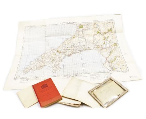
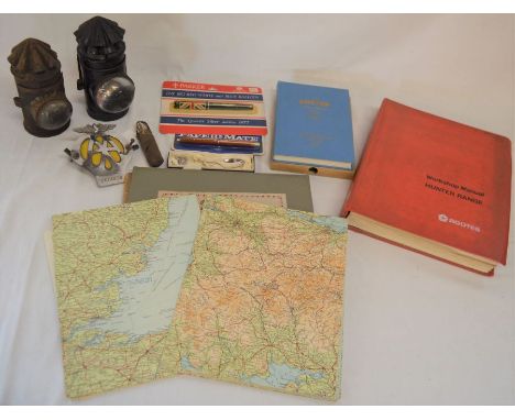
A Bradshaw's Railway Map of England, Wales and Southern Scotland, published by Henry Blacklock and Company Limited, London, Geographia Map of Norfolk, two Ordnance Survey War Revision Maps 1940 of Potmadoc and Criccieth, an Officers Training Corps 1932 Map of North West Hampshire, and a War Office Manual of Map Reading, Photo Reading and Field Sketching 1929.


Lot 425
After Emanuel Bowen. An accurate map of Nottinghamshire, describing it's Wapontakes and divisions, hand coloured engraving, To the Most Noble Thomas Duke of Newcastle, 72cm x 57cm, together with a copy of a map of the county of Nottingham, after a survey by C and J Greenwood, 39cm x 49cm. (2)


Lot 429
After John Ogilby. The Road from Grantham to Tuxford, verso to Doncaster, from Britannia Depicter, hand coloured engraving, published 1720, 18.5cm x 12.5cm, a map of Lincolnshire north from London, by WK Toms, published 1742, 15.5cm x 15.5cm, map of Lincolnshire divided into it's Wapontakes, after Emanuel Bowen, published 1761, 19cm x 17cm, and another map of Lincolnshire after Robert Morden, 22.5cm x 17cm. (4)


Lot 366
Books – approx. 120 antiquarian, modern first editions, academic imprints, local interest, and others, including Davies (The Rev. D.P.), A New Historical and Descriptive View of Derbyshire, Belper: S. Mason, 1811, lacking fold-out map, illustrated with plates, 20th century brown leather gilt over marbled boards, 8vo, (1); further Derbyshire interest; Lawrence Durrell’s Avignon Quintet, first editions, London: Faber 1974-1985, pictorial dustjackets over cloth, 8vo, (5); Irish Murdoch first editions; art history and architecture, including the Renaissance, orangeries, follies, others; The Gardens of Pompeii and Herculaneum; Lewis Napier on 18th century Georgian politics; Diaries of Robert Fulke Greville, 1930, 8vo, (1); Barbellion’s Journals, (3); poetry and literature; philosophy; travel, Bruce Chatwin; antiquarianism and history; bibliography; etc., maps; mostly hardbacks, various sizes; etc., [approx. 120]
Lot 373
Books – approx. 100 books, including Botany, Mrs Delany & Her Circle, Yale Center for British Art, 2010, dustjacket over cloth, 4to, (1); further academic presses, art history, architecture, history; Russia; Folio Society; P.G. Wodehouse, various; The Waverley Edition of the Works of Charles Dickens, (30); Thomas Carlyle’s Reminiscences, two-volume set, first edition, London: Longmans, et al., 1881, original green cloth, 8vo, (2); Children’s Books, four Beatrix Potter titles, F. Warne & Co Ltd, (4); map of Fakenham, Norfolk, (1); Evelyn Waugh, the Brideshead Generation and the Neo-Romantics; a few hardback first edition novels, but mostly non-fiction; diaries and diarists; cookery; etc., [approx. 90]
![Richard Blome (1635-1705), by and after, map, [...] Cumberland (Cumbria) [...], lower-right margin with the coats of arms of](https://cdn.globalauctionplatform.com/eba4e5be-92ca-461b-9027-aecc01017ddd/5d3cf1c7-4f56-4f37-83cc-af0400ffeaad/468x382.jpg)


![Aylett Sammes, Britannia Antiqua Illustrata: or, the Antiquities of Ancient Britain, Vol.1 [all published], Thomas Roycroft,](https://cdn.globalauctionplatform.com/40ceccd6-0887-4c35-8763-aef901063ead/688c7c61-aed6-46b6-abb5-aefd00e8b275/468x382.jpg)


Lot 483
Southampton 1995-96 squad signed shirt, the season they beat Manchester United 3-1 also escaping relegation this season on goal difference. Autographed by 19 as follows, Bruce Grobbelaar, Francis Benali, Gordon Watson, Richard Hall, Neil Maddison, Matt Le Tissier, Jim Magilton, Simon Charlton, Frank Bennett, David Hughes, Neil Shipperley, Neil Heaney, Tommy Widdrington, Kenneth Moncau, Jason Dodd, Dave Beasant, Dave Merrington (manger), Lew Chatterley (1st team coach) and Lawrie McMenemy (director of Football / ex manger), comes with shirt map


Lot 804
A RARE LATE 19TH CENTURY FRENCH BLACK AND ROUGE MARBLE 'WORLD TIME' MANTEL CLOCK the black marble case with rouge mouldings and pillars flanking a glazed pendulum aperture, the 4.5" enamel dial with Roman chapter ring surrounding a map of the world, the night and day rotating outer chapter ring showing the time of various cities and countries around the world fronting an eight-day spring driven movement with Ellicott type compensated pendulum striking the hours/half hours on a bell, the backplate with makers stamp for 'BREVETE, CH. DELAGRAVE'46cm highThe movement is running and striking but we would reccomend a service. The dial has no cracks but has restored chips to the winding holes. The outer dial rotates correctly. The movement strikes the correct hours. The case is dirty but in good condition with no cracks or damage, just some very minor chips to the edge of the base. The drum shaped top is detached from the base and missing two fixing screws that hold it in place. The white porcelain plaque behind the compensated mechanism on the pendulum bob is damaged.
Lot 956
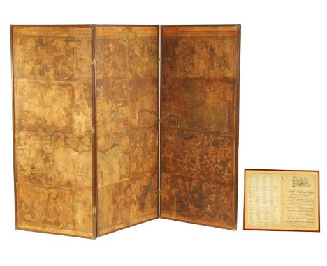
A RARE 18TH CENTURY MAHOGANY FRAMED LARGE TRIPLE FOLDING SCREEN DEPICTING A DETAILED MAP OF THE CITY OF LONDON from a bound volume of the Cities of London and Westminster and Southwark and ten-mile radius, By John Rocque, Land Surveyor and dated 1745 - with accompanying glazed framed fronting page and detailed inventory.195cm high 261cm wide


Lot 340
A BRONZE GUNDOG FIGURE AND A PLATED KANGAROO, comprising a bronze figure of a working pointer, standing on three legs on an unsigned rectangular base, height 8.5cm x length 17.5cm x depth 4cm, together with an early twentieth century silver plated figure of a kangaroo, standing on a base in the form of a map of Australia, by Stokes & Sons, Melbourne, Victoria, partial marks to base (2) (Condition report: bronze appears in good condition, kangaroo in good condition with some polish residue, tarnish, light scratches and slightly bent base)
Lot 567
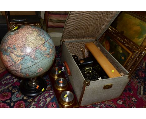
ONE BOX OF FRAMED PRINTS, GLOBE AND SINGER SEWING MACHINE comprising a hard cased early electric Singer sewing machine (not tested), three large gilt framed prints, a wall hanging barometer, clock and hydrometer (battery operated), a modern globe with a 1921 Webber Costello & Co map of the world, six silver metal photo frames and a group of small picture frames (1 box + loose)


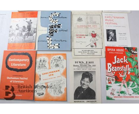
Lot 96
Over 80 Cheltenham and Gloucester theatre and music programmes plus local books and ephemera, including Cheltenham Opera House, Civil; Playhouse, Town Hall, Gaumont, Cheltenham Music Festival 1940/50s, Cheltenham Literature Festival, quantity of early Gloucester 1906-1920 music programmes eg. Gloucestershire Orchestral Society, programme of concert by thepupils of Miss T T Tomes 1906, The Magic Fan 1910 by pupils of Mrs T J Thompson, a WWI 1918 Grand Concert in aid of Cheltenham Racecourse Voluntary Aid Detachment VAD, a souvenir programme of the Gloucestershire Historical Pageant Cheltenham 1908 with super local adverts, Bacon's 1/2" Cycling and Motoring map on linen c1903, a signed Marty Wilde ticket for concert at the New Sarah Siddons, Pittville Street Cheltenham.


Lot 56
A FRENCH MAP OF SOUTHEAST ASIA (1780) Published in Paris, "La Presqu'isle de l'Inde au de la du Gange or L'Archipel des Indes , Partie Occidentale" a map designed by Rigobert Bonne (1727-1795) a French cartographer widely considered one of the most important of the late 18th Century. 46cm wide x 56cm high including frame Condition: Condition Report Good condition, fold as issued, minor damage to the wooded frame left top corner This is an auction of preowned and antique items. Many items are of an age or nature which precludes their being in perfect condition and you should expect general wear and tear commensurate with age and use. We strongly advise you to examine items before you bid. Condition reports are provided as a goodwill gesture and are our general assessment of damage and restoration. Whilst care is taken in their drafting, they are for guidance only. We will not be held responsible for oversights concerning damage or restoration.
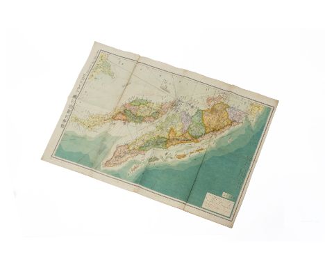
Lot 55
A JAPANESE MAP OF THE MALAY ARCHIPELAGO Dated 1943 Including Sumatra and Thailand, scale of 1:300,0000 76cm x 53cm Condition: For a condition report or further images please email hello@hotlotz.com at least 48 hours prior to the closing date of the auction. This is an auction of preowned and antique items. Many items are of an age or nature which precludes their being in perfect condition and you should expect general wear and tear commensurate with age and use. We strongly advise you to examine items before you bid. Condition reports are provided as a goodwill gesture and are our general assessment of damage and restoration. Whilst care is taken in their drafting, they are for guidance only. We will not be held responsible for oversights concerning damage or restoration.
Lot 53
A SINGAPORE JAPANESE CLUB MAP OF SINGAPORE AND MALAYSIA Double sided, and dated 1942, one side with the Malay archipelago and various keys, a vignette of Singapore Island The reverse with a detailed map of Singapore city with a large index of relevant businesses and places of interest, together with a guidebook dated 1939, with sleeve Map measures 73cm x 54cm Condition: For a condition report or further images please email hello@hotlotz.com at least 48 hours prior to the closing date of the auction. This is an auction of preowned and antique items. Many items are of an age or nature which precludes their being in perfect condition and you should expect general wear and tear commensurate with age and use. We strongly advise you to examine items before you bid. Condition reports are provided as a goodwill gesture and are our general assessment of damage and restoration. Whilst care is taken in their drafting, they are for guidance only. We will not be held responsible for oversights concerning damage or restoration.

Lot 58
A FRENCH MAP OF THE MALDIVES (1750) Published by Didot, Paris "Carte des Isles Maldives", a map from A.F.Prevost's " Histoire Generale des Voyages" (1750-1760) designed by Nicolas Bellin , Cartographer to the King Condition : good , restored in the right centre side , modern colouring 31.5cm wide x 38cm high including frame Condition: Condition Report Good condition, restored in the right centre side, modern colouring This is an auction of preowned and antique items. Many items are of an age or nature which precludes their being in perfect condition and you should expect general wear and tear commensurate with age and use. We strongly advise you to examine items before you bid. Condition reports are provided as a goodwill gesture and are our general assessment of damage and restoration. Whilst care is taken in their drafting, they are for guidance only. We will not be held responsible for oversights concerning damage or restoration.

-
109198 item(s)/page