We found 108737 price guide item(s) matching your search
There are 108737 lots that match your search criteria. Subscribe now to get instant access to the full price guide service.
Click here to subscribe- List
- Grid
-
108737 item(s)/page


Lot 1018
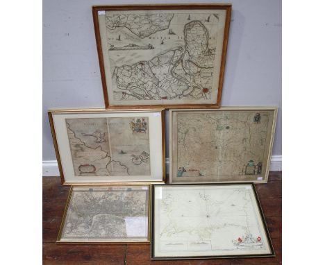
John Speed (British 1542-1629): 'The North and East Ridins of Yorkshire', pub. Thomas Bassett & Richard Chiswell, c.1676, hand coloured engraved map, inset town plans of Richmond and Hull, strapwork cartouche and mileage scale, glazed text verso, 41.5cm x 54cm Condition Report Click here for further images, condition, auction times & delivery costs

Lot 1017
Nathaniel Hill (British fl.1746-1748): 'A Plan of Scarborough....To put this Town in a Pofture of Defence againft the Rebels 1745', 18th century map pub. 1747 by William Vincent 53cm x 65cm and 'Scarborough in the Season 1869', autotype pub 1870 by O'Sarony 64cm x 95cm (2)Notes: The map demonstrates efforts to defend towns like Scarborough against the Jacobite Rebels of 1745, which was an attempt by Charles Edward Stuart to regain the British throne for his father, James Stuart. Condition Report Map not glazed - has been laid down


Lot 246
A miscellany of legal texts relating to the laws governing early roads, canals and railways, comprising: SCOTT (J), DIGEST OF THE GENERAL HIGHWAY AND TURNPIKE LAWS, later bound full leather, London, Edward and Charles Dilley 1778, BATEMAN (J), THE GENERAL HIGHWAY ACT 5 & 6 W. IV. c. 50, London, A Maxwell 1835, GLEN (A), THE LAW RELATING TO HIGHWAYS, London, Butterworths 1883, WEBSTER (R.G.), THE LAW RELATING TO CANALS, fold out map, London, Stevens And Sons 1885, BIGG (J), A COLLECTION OF THE PUBLIC GENERAL ACTS FOR THE REGULATION OF RAILWAYS, London, Waterlow & Sons 1875, and THE CABINET LAWYER: A POPULAR DIGEST OF THE LAWS OF ENGLAND, London, Henry Johnson 1840 (6)
Lot 252
NEWCOURT (R), REPERTORIUM ECCLESIASTICUM PAROCHIALE LONDINENSE: An Ecclesiastical Parochial History of the Diocese of London, 2 vols, first edition, full leather with gilt titles to spine, volume 1 with engraved portrait frontispiece, four plates (three double-page), volume 2 with fold out map, and index of persons and places, printed by Benj. Motte to be sold by Chr. Bateman, Benj. Tooke, Ric. Parker, Jon. Bowyer and Hen. Clements, London 1708-1710 (2)
Lot 698
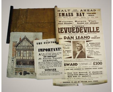
A collection of documents and other ephemera, 19th century and later, to include a rolled canvas map titled 'A Coppy of a Record in the Court Rolls of the Manor of Hawarden in Flintshire' (at fault), a poster advertising a performance by Dan Leano at Gemaes Bay Village Hall in 1938, two political posters relating to the candidacy of Mr Emerson Tennent in the 1834 election in Belfast, Bacon's New Survey Map Of North Wales, two 1947 planning-related maps of Chester etc (Qty)
Lot 699
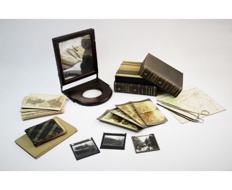
A mixed collection of stereoscopic viewing cards, to include 'Palestine Through The Stereoscope', French architectural landmarks, two photograph tongs, a folding mahogany framed mirrored magnifier, an ordnance survey map of North Wales, two other maps, early 20th century autograph album etc (Qty)


Lot 245
TAYLOR & SKINNER'S SURVEY OF THE ROADS OF SCOTLAND, later bound full leather, gilt title to spine, engraved illustrated title page, lacks prefix map of Scotland, Edinburgh, Thomas Brown, with BARCLAY (H), LAW OF HIGHWAYS IN SCOTLAND, later bound 3/4 leather with marbled boards, gilt title and decoration to spine, Edinburgh, T. & T. Clark 1863, and ARMSTRONG (M.J.), AN ACTUAL SURVEY OF THE GREAT POST-ROADS BETWEEN LONDON AND EDINBURGH, facsimile limited edition, numbered 456 of 500, 1/2 green cloth with marbled boards and green cloth slip case (3)


Lot 8
Mario Andretti signed drivers notes on printed map of the Circuit Park Zandvoort motor racing circuit, includes Very Quick and bumpy, at Scheivlak. Good Condition. All autographs are genuine hand signed and come with a Certificate of Authenticity. We combine postage on multiple winning lots and can ship worldwide. UK postage from £4.99, EU from £6.99, Rest of World from £8.99.
Lot 647
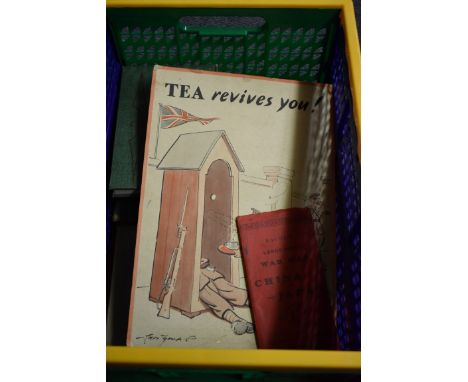
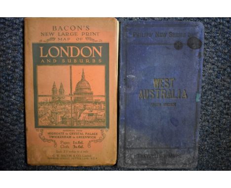
FOLDING MAP: 'Bacon's Large-Print Wall Map of China and Japan'.., London, G W Bacon, circa 1900: colour printed map on paper, folding into original red cloth covers printed in black: TOGETHER WITH a small carton of misc. books, unrelated and printed cartoon 'Tea Revives You!', issued by the Empire Tea Market Expansion Bureau, World War II period. (A box)

Lot 702
(HP) FOLDING MAPS: 'Stanford's War Maps No.1...Central and Eastern Europe..', London, Edward Stanford, circa 1870: folding engraved map hand coloured in outline, printed on paper and laid onto linen, publishers plum cloth boards with printed onlay, VG: TOGETHER WITH a small carton of misc. other folding maps, guides, pamphlets and plays. (Small carton)


Lot 110
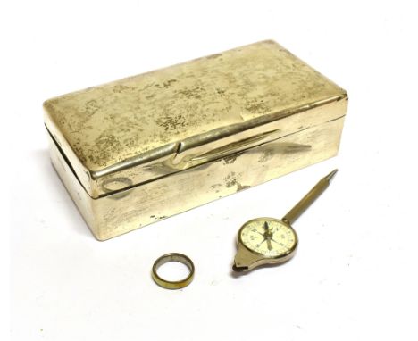
A SILVER MOUNTED RECTANGULAR CIGARETTE BOX AND OTHER ITEMS comprising; a cigarette box with rounded corners and a wood lining, maker's mark not found, London 1919, 5cm high, 18cm wide, 9cm deep (2 x 7 x 3 ½ in); a plated combined map reading propelling pencil, compass and distance calculator, 11.75cm long overall (4 ½ in); and a yellow enamelled base-metal ring, size R+

Lot 295
MILITARIA - A SECOND WORLD WAR SILK ESCAPE MAP comprising, to one side, Sheet E (Germany Protectorate; Slovakia; Poland; Hungary) and, to the other, Sheet F (Croatia (west & central); Montenegro (west); Hungary (west); Slovakia (south); Germany (south); Italy (north & central); Switzerland (east)), 77cm x 87cm; and a smaller silk map, printed to one side only, possibly for the same purpose, 49cm x 52cm, (2).
![[TRAVEL]. EGYPT & OTHER Cromer, Earl of. Modern Egypt, reprint, two volumes, Macmillan, London, 1908, dark green cloth,](https://cdn.globalauctionplatform.com/b0150321-5146-4a27-b181-ab4200d9f24d/c31432ef-88f7-4aa4-878c-ab5300df77ca/468x382.jpg)
Lot 401
[TRAVEL]. EGYPT & OTHER Cromer, Earl of. Modern Egypt, reprint, two volumes, Macmillan, London, 1908, dark green cloth, portrait frontispiece, folding map, octavo; Smith, George. Assyrian Discoveries: An account of explorations and discoveries on the site of Nineveh, during 1873 and 1874, Sampson Low et al., London, 1875, decorative bevelled brown cloth gilt, folding map frontispiece, plate and text illustrations, octavo; and eight other works in nine volumes, (11).


Lot 263
A selection of maps and guides, to include May 1922 Map of the London General Bus Routes; C.C. Trams Map and Guide; The Greater Fort Worth, Texas, Courtesy of Fort Worth Chamber of Commerce; Dallas Ft.Worth; Berlin 14. Auflage; Lucknow the City of Nawabs; Chicago and Suburbs Downtown O'Hare international airport; together with a number of bank notes, to include a Spanish 100 peseta note, 1931; 100 peseta note, 1953; 50 peseta note, 1928; three US one dollar notes; an Estonian 5 Krooni note; a 1 Krooni note; an 100 Kenyan shilling note, 1992; 50 Kenyan shilling note 1996; 20 Danish Kroner note, 1972; and a Bank of England 1 pound note; together with some stamps
Lot 263A
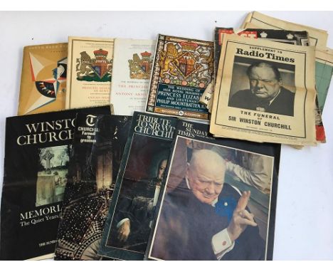
A mixed lot of British Royal Family and Winston Churchill related ephemera, to include the souvenir programme of 'The Wedding of Her Royal Highness Princess Elizabeth and Lieutenant Philip Mountbatten, R.N, Westminster Abbey, 20th November 1947'; Approved Souvenir Programme of the wedding of Her Royal Highness Princess Margaret and Mr Antony Armstrong-Jones, in Westminster Abbey, 6 May 1960; The approved souvenir programme of the wedding of Her Royal Highness Princess Alexandra of kent and the Honourable Angus Ogilvy, in Westminster Abbey 24 April 1963; guide book of South Bank Exhibition London 'Festival of Britain', 1951; Philip's War Map of the World; Picture Post 'Wedding Record', Vol 37. No. 9, November 29 1947; The Sunday Times Colour Section on Winston Churchill, 1962; The Sunday Times Magazine Winston Churchill Memorial Issue, February 7, 1965; The Telegraph Churchill: Farewell to greatness; Sunday Times Magazine 'Who's For the Moon'; The Young-Man: A Monthly Journal and Review, July 1896 etc


Lot 476
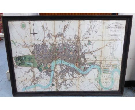
'A plan of London and its Environs', monochrome engraved map by J & C Walker, drawn for Lewis' Topographical Dictionary, drawn by R. Creighton, 40 x 47cm, together with four assorted hand-coloured maps including 'Insvla Sacra Vulgo Holy Island et Farne' and depicting the Isle of Man and surrounding islands etc.


-
108737 item(s)/page