We found 109182 price guide item(s) matching your search
There are 109182 lots that match your search criteria. Subscribe now to get instant access to the full price guide service.
Click here to subscribe- List
- Grid
-
109182 item(s)/page

Lot 3033
Willis, Nathaniel Parker and W.H. Bartlett. American Scenery, 2 volumes, engraved portrait frontispiece, 2 engraved additional titles, 117 engraved plates, map, London: George Virtue, 1840; Canadian Scenery Illustrated, 2 volumes, 2 engraved additional titles, 117 engraved plates, map, lacks engraved portrait, London: George Virtue, 1842; bound together in 3 volumes, some spotting, library blindstamps, contemporary half calf, rubbed, bookplate of Bath Library, 4to
Lot 2919
Atkinson, George Francklin. Pictures from the North, in Pen and Pencil, first edition, tinted frontispiece, library blindstamps, original cloth gilt, bookplate of Bath Library, 8vo, London: John Ollivier, 1848; Vertot, Rene Aubert de. The History of the Revolution in Sweden, sixth edition, modern cloth, bookplate of Bath Library, 8vo, London: John and James Knapton, 1729; Troil, Uno von. Letters on Iceland, second edition, engraved frontispiece, folding engraved map, laid-down, modern cloth, bookplate of Bath Library, 8vo, London: J. Robson, 1780; and 8 others, similar, 8vo (11)


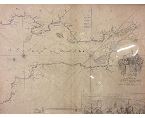
Lot 20
Bristol - ‘The Severn or Channell of Bristoll’ Capt. Greenvile Collins, 1693 this map shows the Bristol Channel, which divides Wales and the western portion of England with the city of Bristol located at the right of the image. The map is filled with rhumb lines, numerous soundings, and a key at centre to important locations. At the lower right is a view depicting the arrival of King William III on 6 September 1690, upon returning from Ireland following the Battle of Boyne and his defeat of James II. Sir Robert Southwell, who accompanied King William III, was the Secretary of the State for Ireland at the time. The map is dedicated to Sir Southwell and is decorated with his coat of arms. In 1681 Capt. Greenville Collins (fl.1669-1694) an officer in the Royal Navy was appointed by the Admiralty to make a complete survey of the coasts of Great Britain. Prior to this date the charts used by English mariners were copies of Dutch charts that had many inaccuracies. The task of surveying the entire coasts was formidable and took about 7 years, at the end of which only 46 surveys were finally used in an atlas titled Great Britain's Coasting-Pilot Being a New and Exact Survey of the Sea-Coast of England, which was first published in 1693, framed and glazed, 56cm x 44cm.


Lot 13
Bristol - ‘Entrance to Bristol From the London Road’ Circa 1830 coloured engraving, drawn by W. Bartlett, engraved by C. Mottram, published by Jones & Co. Temple of the Muses, Finsbury Square, London, Sept 11th 1830 , mounted, framed and glazed, 16cm x 12cm; Bristol - ‘St. Peters Hospital Formerly the Mint’ Circa 1820 from the Memoirs of Bristol coloured engraving, drawn and engraved by F. Blare, printed by McQueen and published by J. M. Gutch, Bristol, August 1st1824, mounted, framed and glazed, 23cm x 20cm, ‘arrival of Rodney in the Bristol Channel’ hand coloured plate, mounted, framed and glazed, 15cm x 9cm; ‘Gloucestershire’ hand coloured map, framed and glazed, 20cm x 27cm, (4).


![John Speede (1552-1629) British. "Shropshyre" [sic], Coloured Map, Unframed, 15.25" x 20".](https://cdn.globalauctionplatform.com/0ee7e3a5-7808-485e-8ac6-a6fe00e187f8/7f9409df-6e47-4e5c-a034-cab8a93c754e/468x382.jpg)


Lot 336
Oxford and Cambridge "FiftyYears of Sport" 1st ed 1913 - in full leather and gilt decorative boards and spine - arranged by Lord Desborough c/w 22 full page portraits to incl Athletics, Cricket and Rowing plus biographies of "Blues" - plus "A Map to Accompany The Record of The University Boat Race" - some slight scuffing to edges but generally overall (G)


Lot 658
Macdonald, Charles Blair -"Scotland's Gift Golf - Reminiscences 1872-1927" 1st ed 1928 published Charles Scribner's Sons, NY in the original red and gilt cloth boards and spine (very faded, stained in places and worn) c/w the original frontis tissue guards together with various other colour plates and photo lithographs and fold out map of the National Golf Links of America to the rear. Owners name hand written to front end plate and some scoring to the lower left hand corner) internally generally clean (A/F)

Lot 15
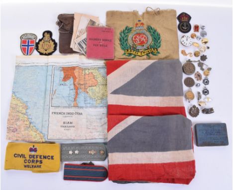
Motor Cycle Racing Isle of Man Tourist Trophy Championship Programmes 1968 onwards includes 68, 69, 70, 74, 75, 76, 79, Map of The Course, 1974 and 1975 Public Road Closure Leaflets, TT Racing by Ray Knight, and a small selection of Motor Cycle TT Review Magazines 1967 (3) overall condition mixed A/G (15)

Lot 660
Masters Golf Annual and other Masters books to incl 1980 Masters Annual held at Augusta National and won by Severiano Ballesteros in original green leather and gilt boards - small tear to the spine and slight wear to the top and tail otherwise (G) and 2x Bisher, Furman - "The Masters, Augusta Revisited - An Intimate View" 1st edition 1976 c/w the original dust jackets, Course map on endpapers complete with all the results from 1934 to 1976 - overall (G) (3)

![English School (early 19th century), map, Derbyshire, Published by Pigot & Co., London [c.1830], steel engraving, contemporar](https://cdn.globalauctionplatform.com/a1c38138-41f6-483e-af04-a70500f2913e/b8c69ca8-b419-42b0-92ad-6af0391292b8/468x382.jpg)

Lot 189
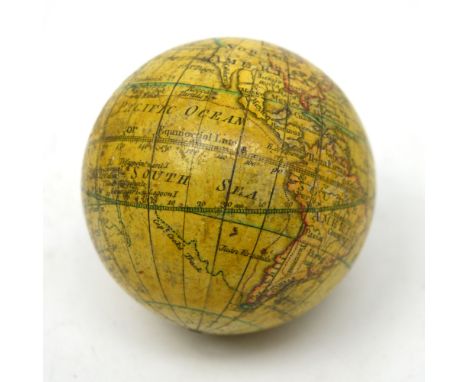
A George III pocket terrestrial globe inscribed 'A New Globe of the Earth by N. Lane', dated 1776, housed within shagreen outer case, the interior of the case with celestial map and signs of the zodiac decoration, approx 7.7cm, the case is af. CONDITION REPORT A small section of the case is missing, it is broken in half and any previous gilt metal or brass fittings from the globe are not present.


Lot 154
English, Thomas H. 'An Introduction to The Collecting and History of Whitby Prints', 1931, Horne and Son, Whitby, two volumes, each hard bound in white cloth with Arms of Whitby in gilt to front boards. Limited edition of 210 copies signed by author of which this is number 151. Volume one contains fold out linen map of Whitby and has two loose letters from the author. (from the collection of the late Richard Moore)


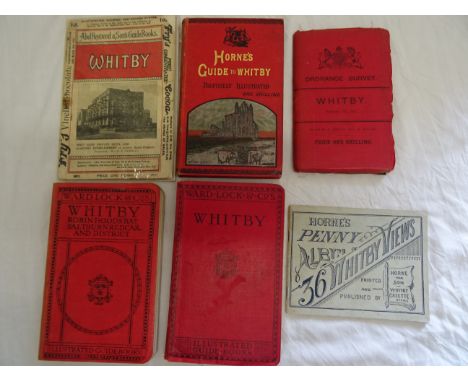

Lot 155
Charlton, Lionel 'The History of Whitby and of Whitby Abbey', 1789, printed by A. Ward, York. Rebound in half leather with gilt to spine. Contains fold out linen map and three engraved plates. Two prints of Whitby c. 1900 have been pasted onto blank pages towards the end of the book. (from the collection of the late Richard Moore)


Lot 139
Four titles illustrated by Gustave Doré, 'Atala' by Chateaubriand, c. 1880, Cassell, London, previous owner's inscription to the half-title page, hard bound in red cloth with gilt to spine. 'The Adventures of Baron Munchausen' c.1880, Cassell Petter and Galpin, London, quarter bound with red leather. Lafon, Mary 'Fierabras', 1857, Librairie Nouvelle, Paris, hard bound in cloth with gilt to spine. 'Le Nouveau Paris Histoire de Ses 20 Arrondissements', c.1860, quarter bound with marbled endpapers and fold out map. (from the collection of the late Richard Moore)


Lot 493
A large quantity of Churchill books to include Secret Session Speeches, Painting as a Pastime and My Early Life, 20 various volumes in total Condition Report: NB. Books are not collated unless specified, and are sold 'as seen'River War - title pages of both volumes state that they are the 2nd impression, printed 1900. Black endpapers intact but one is split at binding. Both volumes bear bookplates for Rose Haig Thomas. Slight spotting, browning and creasing throughout. Volume 1 has occasional pencil or ink lines in the margin, where the reader wished to draw attention to a particular paragraph. The edges of the pages are very rough. We do not guarantee the completeness of these volumes, however all illustrations and maps appear to be there, the photogravures still have their tissue, there is just one map in volume 1 (page 462) where the folded section has been ripped off and is missing.World Crisis - Edges of pages all spotted, slight internal spotting.My Early Life - some pages uncut, others poorly cut with rough edges. Borders foxed. Some spotting in places. Names in ink to flyleaf G Schuter.Painting as a Pastime - dust jacket intact. 3rd impression. No spotting.

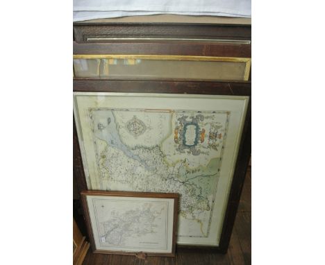
Lot 606
A 19th century black and white print after Holman Hunt - The Light Of The World, 68 x 40cm, a 19th century coloured print showing the First Easter Dawn after F K Thomson both in oak frames with gilt slips, a 19th century coloured map of Gloucestershire from Lewis' topographical dictionary, 27 x 29cm and a reproduction coloured map of Gloucestershire after Saxton

Lot 634
An early 19th century needlework panel of oval form by Anna Hopkins showing a map of England and Wales with parts of Scotland, Ireland and France, the counties delineated and within a floral border, in black and gilt glass mount with floral detailed corners and in gilt frame 51 x 46cm overall frame size


-
109182 item(s)/page