We found 109198 price guide item(s) matching your search

Refine your search

Year

Filter by Price Range
  • List
  • Grid
  • 109198 item(s)
    /page

Lot 103

A framed map of Jersey,Guernsey and other Islands, drawn from a survey of Philip Dumaresq.

Lot 184

An 18th century sea chart of the English Channel, by Robert Seale, 'A correct chart of the English Channel', engraved map, hand coloured in outline with ornamental title cartouche.

Lot 271

A Cold War era scroll map of Germany and Poland

Lot 554

An early 20th century scroll map of England by Scarborough, together with a vintage Phillips Globe

Lot 60

After Robert Gordon, Map of the Highlands, titled Scotiae Provincia ex Timothei Pont, coloured engraving, later impression, 42 x 56cm

Lot 124

A BOX CONTAINING VARIOUS MILITARY WEBBING AND BELTS, to include brown leather early Bandollier RAOC (Royal Army Ordenance Corps), canvas belt and buckle, with cream coloured canvas ammo pouch, a United States (N.G.P.) National Guard, Pennsylvania leather ammo pouch, on a canvas belt with a black leather flap pistol holster, with rivet design on flap, a mint new un-wrapped brown leather belt, 5 x leather rifle slings (old), an open top brown leather rifle case, marked 'D.S.', a green coloured canvas, rifle sling ? with fittings, brown leather oblong ammo pouch, embossed J. Fischer egg, possibly WWI/II era, WWII era folding canvas and wood board map case, complete with maps, pencil holder etc

Lot 113

A folding map of Buckinghamshire by Emanuel Bowen, mounted on cloth

Lot 201

A coloured map of Gloucestershire by Robert Morden; and a framed map of Suffolk

Lot 404

A framed map of Suffolk and an ornate gilt framed mirror

Lot 1633

A framed Inclosure map of Stapleford Abbots, Lambourne and Dagenham in Essex circa 1863.

Lot 1527

Original vintage advertising map: The Mothers' Union World Map. Mothers’ Union is an international Christian charity that seeks to support families worldwide. Its members are not all mothers or even all women, as there are many parents, men, widows, singles and grandparents involved in its work. Its main aim is to support monogamous marriage and family life, especially through times of adversity. Fair condition, tears and creases on margins, tape marks on margins. Country: UK. Year: 1950s. Designer: Unknown. Size: 68.5 x 101.5 cm.
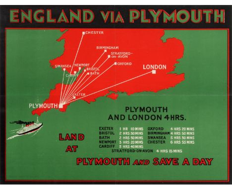
Lot 2308

Original vintage travel advertising poster promoting service routes from Plymouth: England via Plymouth - Plymouth and London 4hrs - Land at Plymouth and Save a Day. Great design featuring a map in red of the southern half of the UK with a steamship approaching the historical harbour port city of Plymouth in Devon marked in white with the routes and journey times listed from Plymouth to several inland cities in England and Wales - Exeter, Bristol, Bath, Cardiff, Oxford, Stratford-upon-Avon, Birmingham, Chester, Newport, Swansea and London - against a green background with the text in stylised green, white, black and red letters. Horizontal. Very good condition, folded as issued. Country: UK, year: 1930s, designer: Unknown, size(cm): 22x29.5 .
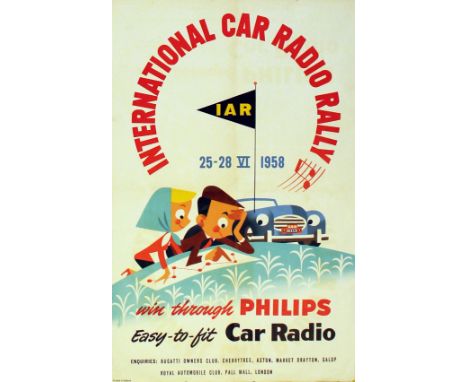
Lot 3503

Original vintage sports poster for the International Car Radio Rally, 25-28 June 1958. Win through Philips, easy-to-fit car radio, enquiries: Bugatti Owners Club, Cherry Tree, Aston, Market Drayton, Salop, Royal Automobile Club, Pall Mall, London. Fun mid-century modern design featuring a couple studying a route map with the IAR flag hoisted on their car. Art by Pot., printed in Holland. Good condition, folded, minor creases, repaired tears.Country: Netherlands, year: 1958, designer: Unknown, size(cm): 54.5x34.5.
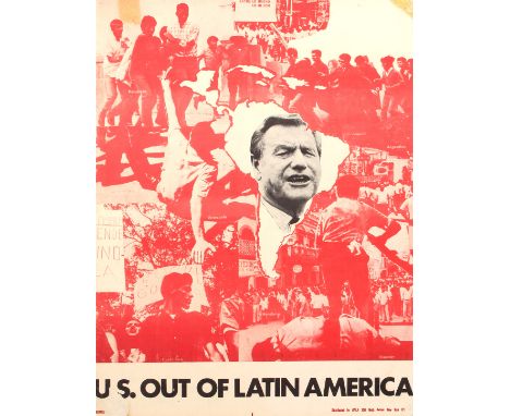
Lot 4701

Original vintage propaganda poster distributed by AVILA: U.S. out of Latin America. This poster features a monochrome photomontage combining images from revolutions and protests across Latin America, including Honduras, Argentina, Venezuela, Costa Rica and Ecuador, while a map of Latin America is displayed in the centre, emblazoned with the portrait of a political figure. The text is printed at the bottom of the poster in black lettering. Fair condition, tape marks and pinholes in corners, folds, cracks and folds. Country: USA, year: 1970s, designer: Unknown, size(cm): 55.5x42.5.
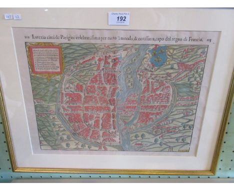
Lot 16

A Manchester Guardian handkerchief 'Map of Europe' and one other. (2)

Lot 306

An antique map of Southern India

Lot 320

'The Sherifdome of Fyfe', a framed map, 58 x 50cm

Lot 191

A map of India from the Descriptio Orbis Antiqui, published in Nurenberg in 1720 by Christopher Weigel. This is a rare item. The map is 31cm x 49cm and in good condition. The frame is glazed at the back so the Latin text associated with the map can be read.

Lot 183

Map of France from the 17th century. The map is 6.5cm x 12cm, carefully hand-coloured and in good complete condition. It has an appropriate modern frame.

Lot 181

Map of England, Scotland and Ireland from 1688 by Robert Morden. The map is 12cm x 13.5cm, carefully hand coloured and in good complete condition. It has been elegantly framed.

Lot 179A

Map of Rutland from 1642 by John Speed, the 17th century cartographer. The map is 42cm x 53cm, the paper containing the contemporary watermark, the map carefully hand-coloured and in good complete condition.

Lot 192

A map of Paris produced in Germany and is probably by Sebastian Munster. Taken from a book as the page numbers 102/103 would indicate. This is a rare item from the 16th century. The map is 29cm x 37cm, carefully hand-coloured and in good complete condition. It has an appropriate modern frame.

Lot 178

A rare map of Roman Britain by Abraham Ortelius, produced in 1595. It is 36cm x 52cm, carefully hand-coloured and in good complete condition. It will have explanatory Latin text verso but this is obscured by an appropriate modern frame.

Lot 186

Map of Hertfordshire from circa 1840 by Thomas Moule. The map is 20.5cm x 26.5cm, carefully hand-coloured and in good complete condition. It has an appropriate modern frame.

Lot 182

Map of Buckinghamshire from circa 1850. The map is 13.5cm x 9cm, carefully hand-coloured and in good complete condition. It has an appropriate modern frame.

Lot 190

A map of Hertfordshire based on the surveys of Christopher Saxton and John Norden, which appeared in Camden's Britannia. The map, which is early 17th century, is 30cm x 36cm, carefully hand-coloured and in good complete condition. It has an attractive modern frame.

Lot 174

A map of London produced in Germany in the late 18th century. The map is 50cm x 59cm, carefully hand-coloured and in good complete condition. On the edges of the map are some attractive pictures of royal residence in or around the capital. The map has an appropriate modern frame.

Lot 189

Map of Buckinghamshire from circa 1820 by Thomas Moule. The map is 27cm x 20cm, carefully hand-coloured and in good complete condition. It has an appropriate modern frame.

Lot 175

A map of Buckinghamshire by the cartographer John Speed, dated 1610. The map is 39cm x 51cm, beautifully hand-coloured and embellished with two town plans and various coats of arms. It is in good complete condition with purportedly Latin inscription verso and in an appropriate modern frame.

Lot 187

Map of Oxfordshire from circa 1800 by Hohn Cary. The map is 21cm x 26cm, carefully hand-coloured and in good complete condition. It has an appropriate modern frame.

Lot 179

A rare map of Brightstowe which we know as Bristol. It comes from Civitates Orbis Terrarum, which was produced in 1572 in Cologne by George Braun and Frans Hogenberg. The map is 33cm x 49cm, carefully hand-coloured and in good complete condition. It will have explanatory Latin text verso but this is obscured by an appropriate modern frame. Condition Report: Good quality colouring, not known when coloured.
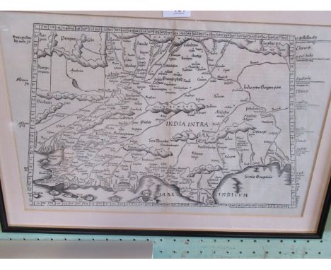
Lot 185

A map of European Settlements in the East Indies by Thomas Kitchin, which was probably included in Abbe Raynal's 1784 publication 'A Philosophical and Political History of the Settlements and Trade of the Europeans in the East and West Indies'. The map focuses on India, 34cm x 35cm, carefully hand-coloured and in good complete condition, though there is some gentle foxing.; It has an appropriate modern frame.

Lot 180

Map of Gloucestershire from 1758 by Emanuel Bowen. The map is 18cm x 20cm, carefully hand-coloured and in good complete condition. It has an appropriate modern frame.

Lot 506

A VINTAGE WWI MILITARY ORDINANCE MAP OF A PART OF FRANCE WITH ATTACK PLAN FOR THE GUARDS DIVISION, SEP 27, 1918. 54 x 61cms.

Lot 532

AN ANTIQUE HAND COLOURED MAP OF WARWICKSHIRE BY ROBERT MORDEN. 37 x 43cms.

Lot 668

A 19th Century county map of Nottinghamshire and an 18th Century map, The Road From London to Barwick featuring The County of Nottinghamshire

Lot 281

A sewing box, card table, wicker basket and a map holder

Lot 1092

A cased set of stirrup cups with cork insets (case marked J C Vickery, Regent St.) and a WW2 silk escape map of Europe (double sided)

Lot 1380M

A physical map of the world on Mercator's projection constructed by W & A.K. Johnston Ltd. A/F

Lot 1663

3 framed and glazed maps including 'The Countie of Lycolne', 'Campagne Francaise de L'Afrique Occidentale Establishments en Afrique' and a reproduction of a 1610 map of the Kingdom of Great Britain

Lot 320

Two engraved and hand coloured strip maps after John Ogilby (1600-1676) consisting of a 17th Century map of ''The road from Welshpool to Caernarfon' 35 x 41cm and a later map of 'The road from Ipswich to Norwich and thence to Cromer', both framed and glazed

Lot 344

A Robert Morden hand coloured map of Norfolk, circa 1700, in a Hogarth frame and glazed, 37 x 58cm

Lot 609

A map divided into eight parts on material "An Actual Survey of the County of Suffolk - to which is added Great Part of Y County of Norfolk", listed with all towns, 50x69cm

Lot 259

FRAMED CALLIGRAPHIC WORK DEPICTING ROBERT THE BRUCE along with a copy map of Aberdeen 1661 by James Gordon

Lot 1104

Saxton and Hole engraved map of the North Riding of Yorkshire with early hand colouring, for Camden's Britannia, together with a collection of miscellaneous photographs and watercolours by J Freeman including ''Sandsend'', J F Rennie, depicting Sandsend etc (qty)

Lot 1033

John Ogilby 'The Road from London' framed, together with a map of West Riding of Yorkshire by Emanuel Bowen (2)

Lot 196

A modern sea chart of the Bristol Channel & an antiquarian map of Poland entitled 'La Pologne' together with a framed print of wild mushroom species

Lot 321

Isle of Wight map from The Illustrated London News, together with three others

Lot 54

An Early 19th Century Map of England and Wales, showing the principal roads, railways, rivers and canals, drawn by R. Creighton and engraved by J. Dower and dated 1839, published by S. Lewis and Co., 205 x 170 cms together with an engraved decorated brass Ankara foot warming stool with circular top above three turned supports, 32 cms diameter

Lot 70

A Coloured Map of Norfolk by S. Hall, together with another map of Kent

Lot 82

An 18th Century Coloured Map of Gloucestershire by Robert Morden, 35 x 42 cms

Lot 83

An 18th Century Coloured Map of Nottinghamshire by Richard Blome, 33 x 26 cms

Lot 695

A silk Bacon's cycling map of England and Wales, 62 x 77cm

Lot 696

A GWR railway line map, 50 x 63cm

Lot 736

An antique map of Germany by Gerardum Mercatorem - 38 x 50cm

Lot 737

A plan map of Birmingham city centre 1731 - 42 x 52cm

Loading...Loading...
  • 109198 item(s)
    /page

Recently Viewed Lots