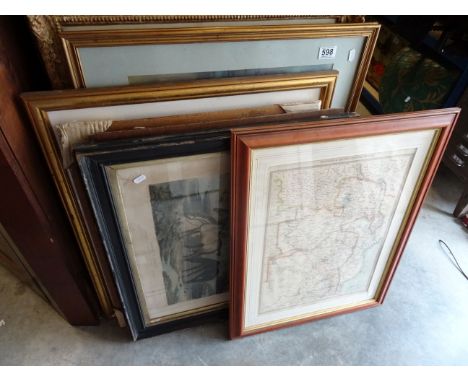
After J. M. W. Turner RA (1775-1851): Stamford, a hand coloured, copper plate engraving, engraved by William Millar, London, published May 1st 1830, for the proprietor by Robert Jennings and William Chaplin, 62 Cheapside, printed by McQueen, the engraving is from the series 'Picturesque Views in England and Wales' of which ninety six scenes were published, together with a hand coloured map of the County of Lyncolne by Richard Blome, 1671, and an engraving of Oriel College, by J. Le Keux, dated 1834. (3)
We found 109198 price guide item(s) matching your search
There are 109198 lots that match your search criteria. Subscribe now to get instant access to the full price guide service.
Click here to subscribe- List
- Grid
-
109198 item(s)/page
A group of ephemera relating to Stamford, comprising two books, W. Harrod; The Antiquities of Stamford and St. Martin's, 2 vols, 8vo, printed by and sold for W. Lowndes, London, 1785, a 1963-4 Dolbys' Directory of Stamford, a Stamford 1953 EIIR Coronation booklet, 1950's folding map of Stamford, a Victorian 'Princess' Album of Stamford', Rock & Co, a photocard of 'Stamford from Meadows', and a 1977 calendar 'Wilfrid Wood's Stamford'. (8)
John Speed, original 17th-century map of the Holy Roman Empire (Central Europe). Hand-coloured copper engraving on laid/chain-lined paper. Sold by Bassett & Chiswell. The map depicts animals, ships, sea monsters, figures in costume; inset views. Framed & glazed with protective/anti-reflective glass. Text to verso just visible but unexamined out of frame.Condition Report: Good, clean and bright for age, some very light foxing.
John Speed, original 17th-century map of Asia. Hand-coloured copper engraving on laid/chain-lined paper. Sold by Bassett & Chiswell. The map depicts animals, ships, sea monsters, figures in costume; inset views. Framed & glazed with protective/anti-reflective glass. Text to verso just visible but unexamined out of frame.Condition Report: Very good, clean and bright for age.
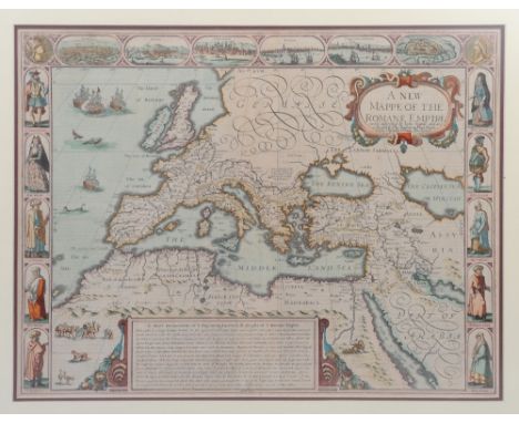
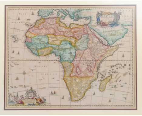
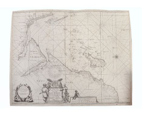
A very rare 17th-century map: 'A Chart of the Western Part of the East Indies'. Featuring dedication to the East India Company. Copper engraving on laid/chain-lined paper, decorative cartouches with figures, uncoloured, unmounted/unframed. Produced by Seller, Colson, Fisher, Atkinson and Thornton. Together with Joan Blaeu 17th-century map of Ethiopia, showing East and Central Africa. Copper engraving on laid paper bearing manufacturer's watermark. Depicts animals/figures, unmounted/unframed, text to verso, backed with a light protective paper. Also, a 'Plan of the Islands of Querimbo, Oybo and Metemo, on the Eastern Coast of Africa', followed by 'Plan of Patta Island with its Harbour on the Eastern Coast of Africa', published in London by Robert Sayer, 'Map & Chart Seller', 20th April 1787. Copper engraving on heavy laid paper, uncoloured/unmounted/unframed. (3)Condition Report: East Indies clean and bright for age, some faint wear / light repairs upper-left; Blaeu has several areas of wear/repairs, cleaned with few areas of colour remaining; Querimbo clean and bright for age.
Derbyshire & Norfolk interest: A unique 18th-century manuscript estate plan relating to the Coke family of Longford Hall and Holkham Hall. 'A Map of the Manor of Longford in the County of Derby, the Estate of Wenman Coke, Esq. Survey'd in April 1763. By Beighton.' Manuscript map, entirely hand-drawn in black ink on laid/chain-lined paper, backed with linen. Large: approx. 132 x 134cm.Note: This Lot is subject to The Manorial Documents Rules 1959, 1963 & 1967 requiring the successful bidder to notify The Secretary of The Commission at National Archives providing details of where it will be kept. In no circumstances can it be removed from England and Wales without prior consent of The Master of the Rolls.Condition Report: Some wear, a little loss, overall a very handsome Georgian map.
Derbyshire & Norfolk interest: A unique 19th-century manuscript estate plan relating to the Coke family of Longford Hall and Holkham Hall. 'Map of Estates situate in the townships of Longford Hollington Shirley and Rodsley in the County of Derby, the Property of the Honorable Edward Coke 1846.' Manuscript map, entirely hand-drawn in black ink with watercolour, produced by John Bromley, Surveyor, Derby 1846. Label for Edward Stanford, Cartographers, London. Backed with linen. Large: approx. 119 x 95cm.Condition Report: Good considering age, a little wear/loss at lower-left. A very attractive antique map.
A rare 17th-century map of Wales by John Speed. Copper engraving on laid/chain-lined paper with early hand-colouring. The map includes vignettes of cities and towns, and depicts ships and sea monsters. Framed & glazed with 'Alfred Pope, London' label to verso. Together with a 17th-century map of Africa by Philip Chetwind, 1666, hand-coloured engraving on laid paper. The map shows various animals, ships and sea monsters. Framed & glazed. (2)Condition Report: Good, very clean and bright for age. Unexamined out of frames. Africa map mounted within engraved borders.
WILLIAM TUNNICLIFF; an 18th century engraved 'New Map Of Cheshire By William Tunnicliff Land Surveyor 1786', 28.5 x 36.5cm, a hand coloured example by John Cary and five further smaller maps, some later, all of Cheshire (7). CONDITION REPORT: Areas of staining, discolouration, fold, creases and printing process errors to first example, others in generally acceptable condition with minor creases, discolouration, etc.
A John Speed coloured map 'The Kingdome of Great Britaine and Ireland Graven by I.Hondius and are to be folde by I.Sudbury and George Humble in Popes head Alley in London.Cum privilegio Regis 1610', mounted and framed, glazed front and rear, map size 37.5 x 50.5cm, frame size 58 x 70.5cm. Condition report: Rear glazing cracked.
FIVE FRAMED AND GLAZED PICTURES, INCLUDING FOUR PRESENTED TO MAJOR HOLMES the first depicting a line infantryman (Clairon); the second a footsoldier (Clairon); the third the camp of the 4th division, dated July 15th 1855; the fourth a poster for the Hampshire Regiment dance; the fifth a map of Operation Joint Guardian, signed by General Sir Mike Jackson KCB CBE various sizes (5)
![Loading...](/content/bs/images/ajax-loader.gif)
-
109198 item(s)/page