
Hall (Captain Basil). Extracts from a Journal, Written on the Coasts of Chili, Peru, and Mexico, in the Years 1820, 1821, 1822, 2 vols. in one, 2nd ed., Edinburgh, 1824, folding engraved map (repaired to verso), some offsetting and light spotting, modern calf-backed boards, 8vo, together with Kidder (Daniel P.), Sketches of Residence and Travels in Brazil, Embracing Historical and Geographical Notices of the Empire and its Several Provinces, 2 vols., 1st US ed., Philadelphia, 1845, plates and illustrations, vol. II frontispiece detached, some spotting, previous owner inscriptions, original green cloth gilt, a little rubbed, 8vo, plus Stephens (John Lloyd), Incidents of Travel in Central America, Chiapas, and Yucatan, Revised from the Latest American Edition with Additions, by Frederick Catherwood, 1854, map, wood-engraved illustrations, some offsetting and light toning, presentation inscription, armorial bookplate of Lord Avebury, original blue cloth gilt, rebacked, a little rubbed, 8vo, with other South America travel including Captain F.B. Head's Rough Notes Taken During some Rapid Journeys across the Pampas and among the Andes, 2nd ed., Charles A. Washburn's The History of Paraguay, Boston, 1871, Thomas Sutcliffe's Sixteen Year in Chili and Peru from 1822 to 1839, 1841 (lacking frontispiece), Colonel J.P. Hamilton's Travels through the Interior Provinces of Columbia, 2 vols. in one, 1826 (lacking one plate), and W. Parker Snow's A Two Years' Cruise off Tierra del Fuego, the Falkland Islands, Patagonia, and in the River Plate, 2 vols., 1857 (lacking one plate), and South American Handbook. The South American Handbook, 1924-1960, a run, commencing with the forerunner Anglo-South American Handbook for 1921, ed., W.H. Koebel, duplicates of 1928 and 1936, and another three volumes (for 1965, 1971 & 1984, plus two others related), colour maps and advertisements, occasional light spotting, toning and waterstains, one or two ex-libris with ownership inscriptions, original cloth, occasional fading and one or two tears, some in 2/6 or 3/6 d.j.s (some tears and losses), 8vo The series commenced with the Anglo-South American Handbook for 1921 (another was published for 1921-22), no volume published in 1923 owing to the death of editor W.H. Koebel, before recommencing as The South American Handbook in 1924, and still published today. (93)
We found 109198 price guide item(s) matching your search
There are 109198 lots that match your search criteria. Subscribe now to get instant access to the full price guide service.
Click here to subscribe- List
- Grid
-
109198 item(s)/page
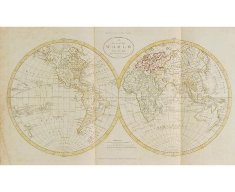
Guthrie (William). Untitled atlas volume, published C.Dilly & G.Robinson, 1785, folding hemispheral map of the world and a folding Mercator's projection map of the world and twenty-two double page engraved maps (including three folding) all with contemporary outline colouring, near contemporary manuscript titles to verso of maps, slight spotting largely confined to endpapers and pastedowns, pencil drawing of Stonehenge to verso of rear endpaper, hinges and joints weak, contemporary half calf, rubbed, worn and frayed, slim folio Sold as a collection of maps, not subject to return. (1)
Cesnola (Alexander Palma di). Salaminia (Cyprus), The History, Treasures, & Antiquities of Salamis in the Island of Cyprus, 2nd ed., 1884, wood-engraved half-title, colour lithograph frontispiece, single-page map, numerous black and white illustrations, single advertisement leaf to rear, ex library copy with usual stamps, including perforated stamp to half-title, occasional offsetting, contemporary half calf, slightly rubbed, large 8vo, together with Cesnola (General Louis Palma di). Cyprus: Its Ancient Cities, Tombs, and Temples. A Narrative of Researches and Excavations During Ten Years' Residence in that Island, 1st US edition, New York, 1878, portrait frontispiece, map and illustrations, contemporary previous owner signature, rear hinge breaking, front hinge reinforced, t.e.g., contemporary green half morocco, rebacked with original spine relaid, 8vo Blackmer 1237 (for the first English edition of 1877), for the second work. (2)
Harrison (Alfred H.). In Search Of A Polar Continent, 1905-1907, 1st edition, 1908, 52 black and white illustrations including frontispiece, colour folding map to the rear, ex-libris bookplate and stuck down newspaper clipping to the front pastedown, some minor spotting, original gilt-decorated red cloth, spine slightly faded, 8vo, together with Yeo (John), Steam And The Marine Steam-Engine, 1st edition, 1894, numerous black and white illustrations including frontispiece with tissue guard, bookplate to front pastedown, stamp to the verso of title-page, some minor spotting, contemporary half morocco, boards and spine slightly rubbed with slight loss to head and foot, 8vo, and Bain (J. Arthur), Life and Explorations of Fridtjof Nansen, new edition, 1898, 15 black and white illustrations including a map, some minor spotting, original gilt-decorated blue cloth, spine slightly rubbed to head and foot, 8vo, plus other 19th and 20th-century travel reference and related, G/VG, 8vo/folio (2 cartons)

Waller (John Augustine). A Voyage in the West Indies: Containing Various Observations made during a Residence in Barbadoes, and Several of the Leeward Islands; with some Notices and Illustrations Relative to the City of Paramarabo, in Surinam, 1st ed., 1820, engraved map, six aquatint plates, some light offsetting, waterstains, modern olive panelled calf, 8vo Sabin 101114. (1)

South America. Bru‚ (Adrien Hubert), Nouvell Carte de L'Amerique Meridionale et des Iles qui en D‚pendent..., published Paris, 1834, large engraved map with contemporary outline colouring, sectionalised and laid on linen, on two sections, seven inset maps of islands, table of explanation, 1800 x 1230 mm, publisher's label to each section, marbled chemise (1)
Roberts (Lord of Kandahar). Forty-one Years in India, volumes 1 & 2 (complete), 28th edition, 1898, 40 black and white illustrations with tissue guards, including frontispiece and 1 map, some light spotting, original gilt-decorated blue cloth, spines slightly rubbed to head, 8vo, together with Oldenberg (Hermann), Buddha: His Life, His Doctrine, His Order, 1882, some light spotting, original gilt-decorated cloth, boards and spine slightly rubbed to head and foot, 8vo, and Copleston (Reginald Stephen), Buddhism, primitive and present in Magadha and in Ceylon, 1892, some slight spotting, original blue cloth, spine slightly faded and rubbed with minor loss, 8vo, plus other late 19th and 20th-century India & Buddhism historical reference and related, all hardback publications, some original cloth in dust jackets, G/VG, 8vo (3 shelves)
Wooster (David). Alpine Plants: figures and descriptions of some of the most striking and beautiful of the Alpine flowers, 2 volumes in 1, 1872-74, 108 hand-coloured illustrations with tissue guards, some minor spotting, rebound in modern green cloth, spine slightly rubbed to head and foot, 4to, together with Turrill (W.B.), The Plant-Life of The Balkan Peninsula, A Phytogeographical Study, Oxford, 1929, signed by the author to title-page, 10 black and white illustrations including frontispiece, 11 black and white maps including folding map to rear, original blue cloth in price-clipped dust jacket, covers slightly toned, 4to, plus Pratt (Anne), The Ferns of Great Britain, and their allies the club-mosses, pepperworts, and horsetails, circa 1870, 41 coloured illustrations, bookplate to front pastedown, inscription to front endpaper, original gilt-decorated green cloth, boards and spine slightly rubbed, plus other 19th and 20th-century UK, Alpine and European botanical reference and related, mostly hardback publications, some original cloth in dust jackets, G/VG, 8vo/4to (3 shelves)
Wales. Speed (John), Montgomery Shire, 1st edition, published John Sudbury & George Humble, [1611], uncoloured engraved map, inset town plan of Montgomery, slight worming to image, repaired on verso, central fold strengthened on verso, vertical margins trimmed with slight loss, 385 x 510 mm, English text on verso, together with, Denbighshire, published Thomas Bassett & Richard Chiswell, cira 1676, uncoloured engraved map, inset town plan of Denbigh, slight creasing, central fold partially split, strengthened on verso, some staining, 385 x 510 mm, English text on verso, with, Caermarden Both Shyre and Towne described, published Thomas Bassett & Richard Chiswell, circa 1676, uncoloured engraved map, inset town plan of Carmarden, some staining, 385 x 510 mm, English text on verso (3)
Smith (Thornley). South Africa Delineated; or, Sketches, Historical and Descriptive, of its Tribes and Missions, and of the British Colonies of the Cape and Port-Natal, 1st edition, 1850, six engraved plates (including frontispiece), publisher's advertisements at rear, occasional spotting, original cloth gilt, spine torn, 8vo, together with Ellis (William), Three Visits to Madagascar during the Years 1853 - 1854 - 1856, Including a Journey to the Capital. With Notices of the Natural History of the Country and of the Present Civilisation of the People, 1858, wood engraved folding frontispiece, plates and illustrations, single-page engraved map, signature to upper margin of title, occasional spotting, contemporary half calf, rubbed, 8vo, plus 4 others, Chips from Tunis: A Glimpse of Arab Life, by Madame Barbe Patteson, [1885], The New Playground or Wanderings in Algeria, by Alexander A. Knox, 1881, The Martyr Church: A Narrative of the Introduction, Progress, and Triumph of Christianity in Madagascar, by William Ellis, 1870, and The Drama of Madagascar, by Sonia E. Howe, 1938, all original cloth, 8vo (6)

Poland. Schenk (Pieter), Friderico Augusto vere Augusto Polan. Lithuan. Boris. Pomer Regi Duci Principi..., 1705, engraved map with contemporary outline colouring, inset map of Saxony, large ornate cartouche, slight oxidisation to old watercolour causing slight cracking, 490 x 580 mm, together with, Homann (Johann Baptist, heirs), Comitatus Glaciensis Tabula Geogr..., 1747, engraved map with contemporary hand colouring, some spotting and staining, one smal repaired marginal closed tear, 480 x 550 mm (2)

Pembrokeshire. Speed (John), Penbrokshyre described and the Sittuations both of Penbroke and St. Davids shewed in due form as they were taken..., published Roger Rea, [1662], uncoloured engraved map, inset town plans of Pembroke and St. Davids, small library blind stamp to margin, one 'printer's crease' affecting image, occasional marginal closed tears, 385 x 515 mm, English text on verso (1)
Rogers (Samuel). Italy, A Poem, printed for T. Cadell, Strand, 1830, black and white illustrations, some light spotting, a.e.g., contemporary gilt-decorated green morocco, boards and spine slightly rubbed with minor loss to head and foot, 8vo, together with Bartlett (W.H., [illustrator]), The Scenery and Antiquities of Ireland, volumes 1 & 2 bound in 1, circa 1840, numerous black and white illustrations with tissue guards, some light spotting, contemporary gilt-decorated blue half morocco, hinges and spine slightly rubbed with minor loss to head, large 4to, and Williams (S. Wells), The Middle Kingdom; a survey of the geography, government, education, social life, arts, religion, &c., of The Chinese Empire and its inhabitants, volumes 1 & 2, 1848, numerous black and white illustrations, black and white folding map to front of volume 1, some light spotting, original green quarter morocco on yellow illustrated boards, boards and spine slightly marked and rubbed, 8vo, plus 3 Anglo-Indian gouache on mica miniature paintings of domestic scenes, some paint loss, mica cracked with some loss, and other 18th and 19th-century antiquarian literature and historical reference including Lives of the Queens of England... by Agnes Strickland, volumes 1-8 (complete), 1861, contemporary uniform gilt-decorated calf, condition is generally good/very good, 8vo/4to (3 shelves)
Crane (Florence Hedleston). Flowers And Folk-lore From Far Korea, 1st edition, Japan, 1931, 45 tipped-in colour plates with tissue guards, illustrated endpapers, inscription to front endpaper, some light spotting, original gilt-decorated black cloth, spine slightly rubbed to head and foot, large 4to, together with Shaw (Norman), Chinese Forest Trees and Timber Supply, 1st edition, 1914, 33 black and white illustrations including frontispiece with tissue guard plus folding map, some slight spotting, original red cloth, spine slightly faded, 8vo, and Beddome (R.H.), Handbook to the Ferns Of British India, Ceylon and the Malay Peninsula, 1883, 300 black and white illustrations, inscriptions to half-title, ex-library stamp to title, some light spotting, original decorative brown cloth, boards and spine slightly rubbed, 8vo, plus other 19th and 20th-century India, China, Indonesia & Australian botanical and historical reference and related, including publications by Hakluyt Society, Antique Collectors' Club, some odd volumes, many original cloth in dust jackets, G/VG, 8vo/4to (3 shelves)

Egypt and Middle East. Michalet (Estienne), Les Deserts D'Egypte de Thebaide D'Arabie De Sirie &c: ou sout exactement Marques les Lieux Habitez par les Saincts Peres des Deserts, published Paris, 1693, engraved map with sparse contemporary outline colouring, some oxidisation to old watercolour causing some splitting, central fold partially split and strengthened on verso, one small hole to image, slight creasing, 565 x 775 mm (1)

Trollope (Anthony). South Africa, 2 vols., 1st ed., 1878, half titles, folding map to vol. I (with tear and repair to verso), scattered spotting, small inkstamps, previous owner signature to half titles, top edge gilt, contemporary burgundy half morocco by Sotheran, a little rubbed, 8vo, together with North America, 2 vols., 3rd ed., 1862, folding map to vol. I (with closed tears), one or two light spots, top edge gilt, later red half morocco by Sangorski & Sutcliffe, 8vo, plus The West Indies and the Spanish Main, 3rd ed., 1860, similarly bound (5)


An 18th century coloured map of the Alpine region including Switzerland, Northern Italy, etc and inscribed - Rhaetia Foederata and further inscribed Gabrielen Walserum Homannianis Heredibus, Nuremburg 1768, 51 x 61 cm approx in black and gilt Hogarth type frame together with an early 20th century coloured print on silk of an Alpine chalet, indistinctly signed bottom right Hans Pris (?), 23 x 31 cm approx in silver coloured frame
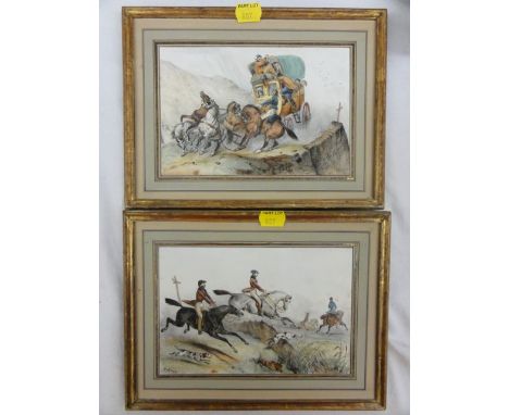
A pair of 19th century coloured lithographs showing a dramatic coaching scene and a hunting scene, one signed bottom left F Adam, 13 x 20 cm approx in gilt frames together with three early 19th century unframed coloured etchings including Jacko Macauco or The Game Monkey after Henry Alken, a coursing scene after Henry Alken, etc together with a late 18th century engraved map of the country around Seringapatam with the field of battle and situation of Tippoo's Army 1791, an early 19th century engraved view of King William Street from Grace Church Street to Lombard Street showing the elevations of the properties, published by John Tallis, etc

A collection of 18th century travel books, The Antiquities of Ireland by Francis Crole, 2 volumes 1791 with steel and other engravings, Topographical Remarks of Hampshire, 2 volumes by the Rev Richard Warner 1793, A Journey from Aleppo to Damascus with a description of those two capital cities and the neighbouring part of Syria including a map, 1736, A Voyage to Arabia translated from the French, published 1732 and Remarks on Forest Scenery and other woodland views, third edition in two volumes by William Gilpin, published 1808 (with illustrations)
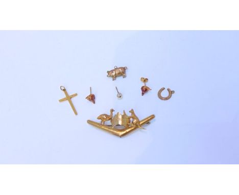
A pair of 9ct gold stud earrings, each with fox head motif, ruby-set eyes, 1.8g in total; a 9ct gold horseshoe charm, 0.8g; a 9ct gold crucifix pendant, 1.2g; a 9ct gold Australia brooch, composed of a boomerang mounted with a kangaroo, emu and map of Australia, 2.2g; a 9ct gold pig charm, 0.9g; and a 9ct gold stud earring, 0.4g (7)


J G HARROD AND CO'S POSTAL AND COMMERCIAL DIRECTORY OF NORFOLK AND NORWICH INCLUDING LOWESTOFT IN THE COUNTY OF SUFFOLK …, L and Norwich 1868, 2nd edn, rebnd qtr cf worn, new EPs + KELLY'S DIRECTORY OF NORFOLK AND SUFFOLK 1908, the defective lacks ttl pge and map, several leaves at front loose, orig cl v worn and soiled, bkstrip detchd (A/F) (2)


PIERRE VERHAEGEN: LA DENTELLE ET LA BRODERIE SUR TULLE, Brussels, Office de Publicite and Societe Belge de Librarie 1902, 2 vols, vols 4 and 5 in the series, "Les Industries a Domicile en Belgique", vol 1 col'd frontis + 132 black and white plts, vol 2 53 black and white plts including some full page and fdg, lace fdg map, each complete, orig cl gt (2)


![GULIELMUS [WILLIAM] CULLEN: SYNOPSIS NOSOLOGIAE METHODICAE, EXHIBENS CLARISS VIRORUM …, Edinburgi, Gulielmum Creech, 1785, 2](https://cdn.globalauctionplatform.com/9d55733c-0c9d-4ccc-923e-a58300e60806/b47658fe-e036-40b4-df9d-fb1039c39b61/468x382.jpg)
GULIELMUS [WILLIAM] CULLEN: SYNOPSIS NOSOLOGIAE METHODICAE, EXHIBENS CLARISS VIRORUM …, Edinburgi, Gulielmum Creech, 1785, 2 vols, orig qtr cf worn, vol 1 top bd near detchd + RICHARD KEARTON: WILDLIFE AT HOME, 1898, 1st edn, association copy, sigd and inscr by author Richard Kearton to J Whitaker Esq and dtd December 22nd 98, and sigd by the ill Cherry Kearton beneath + Richard Kearton ALs to J Whitaker attached to hf ttl, orig pict cl gt + WILLIAM SWAINSON: THE CABINET CYCLOPAEDIA, L, 1840, added engrd ttl, old hf cf, spine gt in compartments + H G O BLAKE (ED): SUMMER FROM THE JOURNAL OF HENRY D THOREAU, Boston and NY 1884, fdg map frontis, orig cl gt + THE ROYAL HORTICULTURAL SOCIETY (PUB): THE LINDLEY LIBRARY CATALOGUE OF BOOKS PAMPHLETS MANUSCRIPTS AND DRAWINGS, 1927, orig cl gt + OLIVER G PIKE: NATURE PHOTOGRAPHY, L, 1931, orig cl, d/w + two others similar (9)

GUILLAUME DE L'ISLE: ATLAS NOUVEAU CONTENANT TOUTES LES PARTES DU MONDE…, Amsterdam, Jean Covens and Corneille Mortier, circa 1742, added engrd ttl, additional ttl for Nicolas Sanson's "Introduction A La Geographie", map list undated, 106 dbl pge hand col'd engrd maps, 2 dbl pge un-coloured engrd plans, lge fo, 20th Century qtr cf, lib shelf no at foot of spine, no other lib markings


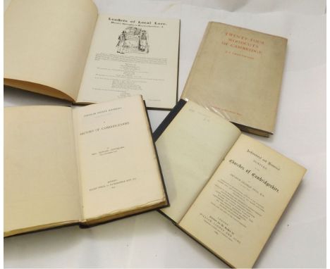
ARTHUR GEORGE HILL: ARCHITECTURAL AND HISTORICAL NOTICES OF THE CHURCHES OF CAMBRIDGESHIRE, L, 1880, 1st edn, old cl gt worn + REV EDWARD CONYBEARE: A HISTORY OF CAMBRIDGESHIRE, L, 1897 1st edn, fdg map, orig qtr cf gt worn, teg + J F GREENWOOD: TWENTY-FOUR WOODCUTS OF CAMBRIDGE, L, John Lane, The Bodley Head Limited, 1926, limited edn (850) numbered, 24 woodcuts compl, orig cl bkd bds, ptd paper label to top bd and to spine, d/w + "URBS CAMBORITUM" PSEUDONYM WILLIAM ROBERT BROWN: LEAFLETS OF LOCAL LORE, circa 1895, [32pp] of "Cambridgeshire Cameos", rebnd cl (not recent) by Wilson & Son Binders, Cambridge (4)


A hand tinted map of the Isle of Man dedicated to Sir John Lowther, circa 1774 The map with the Isle of Man, Anglesey and the Cumberland coastline, 44x56cm, framed and glazed, map of Cumberland by John Speed, 39x51cm, framed and glazed, hand tinted map of the county of Westmorland dedicated by Richard Blome, 32x25cm, framed and glazed, four further 19th Century coloured maps of Lancashire all framed and glazed, and a copy of Maps and Map Makers by R. V. Tooley published by B. T. Batsford Ltd 1961. (9)

-
109198 item(s)/page