We found 109198 price guide item(s) matching your search
There are 109198 lots that match your search criteria. Subscribe now to get instant access to the full price guide service.
Click here to subscribe- List
- Grid
-
109198 item(s)/page


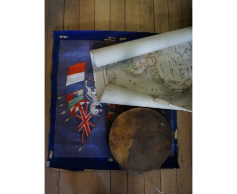
Lot 264
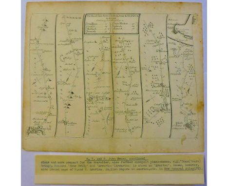
JURASSIC PARK (1993) - Jurassic Park Brochure A visitor’s brochure from Steven Spielberg’s Oscar®-winning action-adventure Jurassic Park. The park’s brochures were used throughout the film at various locations, including the Visitor’s Centre and in the Ford Explorer tour vehicles. This double-sided paper brochure features a printed map of Jurassic Park on the front, pinpointing different sites on the island including the Visitor’s Centre, helipad, electric fencing and dinosaur enclosures. The reverse shows a printed drawing of the park gates with general information including Japanese section of text, a Kodak film advertisement and a mountain terrain photograph that makes up the front cover of the brochure when folded. Displaying evidence of use, including mud staining and tears along the brochure folds, the piece remains in a fair condition. Dimensions (folded):21 cm x 9.5 cm (8 ¼" x 4 ¾") VAT Status - Margin TRIANGLE
Lot 91
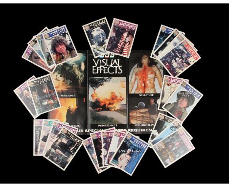
DOCTOR WHO (TV 1963-1989) - Autographed Collectors Card Set A set of autographed collectors cards from the BBC sci-fi television series Doctor Who. The set consists of 26 cards autographed by various VFX crew members who worked on the series. Each card displays an image from the show on the front, with a description of the episode it is featured in on the reverse. Accompanying the cards is a double-sided BBC Visual Effects leaflet, a department which closed after almost 50 years of production in 2003. It features a printed map and contact details, with a brief biography and examples of work. These pieces show minimal wear from age. Dimensions (leaflet unfolded): 29.5 cm x 21 cm (11 ¾" x 8 ¼"); (cards): 9 cm x 6.5 cm x 1.5 cm (3 ½" x 2 ½" x ½") VAT Status - Margin


Lot 295
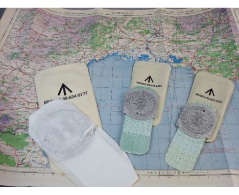
A 1940'S AIR MAP FOR MARSEILLE and three aviation hand held computers, manufactured by the London Nameplate Company Ltd, two computer dead reckoning Mark 5A in sleeve cases with broad arrow marking no. 6B/6605-99-634 and a computer dead reckoning Mark 4B, the sleeve case marked with broad arrow no. 6B/6605-99-634-9777


Lot 109
ROBERTS, Captain George:The four years voyages of Captain George Roberts,Being a series of uncommon events, which befell him in a voyage to the islands of the Canaries, Cape de Verde, and Barbadoes, from whence he was bound to the coast of Guiney. Printed for A Bettesworth, 1726, 1st edn. 8vo., ppvi, 458, folding map and 4 engraved plates. Contemporary full leather; rubbed, spine cracked and chipped at top with small loss; interesting inscription to front blank endpaper; stamp to bottom of title page; corners of a large number of pages chewed away (well away from text)

Lot 4
BAIN, J (editor):The Authentic Map Directory of London and Suburbs,Geographia, (1936), fourth edn. the last pre-war edition, complete with key map, large-scale street plan of London and suburbs in 173 sections, a plan of the City in 3 sections, additional maps of parliamentary, administrative, police, the underground, home counties, postal districts, etc., with index to over 43,000 names, 191 colour-printed map sheets. 4to.; original cloth; spine detached; o/w G+
Lot 111
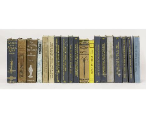
EXPLORATION AND TRAVEL:1. Lamont, J: Yachting in the Arctic Seas. Chatto and Windus, 1876, 1st edn. maps and plates; ppviii, 378, 12 (publishers catalogue dated November 1875). Original cloth, gilt decorative spine; head and foot of spine chipped; occasional foxing;2. Markham, C R: The Threshold of the Unknown Region. S Low, 1873, 2nd edn. maps and charts. Original pictorial cloth; worn and torn; frontis map frayed at edges; foxing;3. Chatwin, Bruce: In Patagonia. J Cape, 1977, 1st edn. dw. Fine copy;4. Elgood, P G: The Transit Of Egypt. E Arnold, 1928, 1st edn. dw; browning and foxing; o/w VG;5. Trungpa, C: Born in Tibet. 1966, 1st dw; fine;6. Nansen, F: First crossing of Greenland. Volume 2 only of two. 1890, 1st; covers worn;7. Hydrographic Department, Admiralty (Publishers): Pilot. 1930’s to 1950’s; including: West coast of Spain and Portugal; Baltic (2 volumes); Mediterranean (3 volumes); Bay of Biscay; North Sea; West Indies; Norway; etc. all in original

Lot 159
GENEVA BREECHES NEW TESTAMENT:Christopher Barker, 1581 (dated title page), ppTP, (vi), 441-554 leaves, collated complete. Possibly taken out of a complete bible with the Old Testament, etc. Hence the pagination. The volume starts with: The Genealogies Recorded in the Sacred Scripture (not complete); ppTP, to reader, 1-8, 13-18, 23-24, (iv) double-page map and description of Canaan; followed by: The Bible, Robert Barker, 1614; pp(iv)TP etc., 1-358 leaves (complete); followed by: the New Testament (mentioned above); followed by: Two Right Profitable. C Barker, nd; etc. The whole bound in 18th century full leather, worn and covers detached; a couple of pages in the 1614 Bible are torn with small loss; many pages and gatherings are loose, including the New Testament, which is in one block. Sold A/F and not subject to return
Lot 125
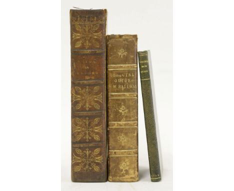
BRITISH TOPOGRAPHY:1. Wade, W M: Walks in Oxford. Two volumes in one. W Baxter, for R Pearson, 1817, folding map, frontis, plus 12 plates; pp536(continuous pagination). Contemporary full calf; rubbed and rebacked with the original spine; offsetting; o/w G+;2. The New Bath Guide. Bath, Cruttwell, 1796; folding plan, 2 plates, and 3 portraits; pp80. Full leather; VG;3. Measom, G: The Official Illustrated Guide to the North-Western Railway (including the Chester and Holyhead line), and all their branches: including descriptions of the most important manufactories in the large towns on the lines. WH Smith and Son, nd with 360 illustrations; pp574. Contemporary half leather; G+ (3)

Lot 117
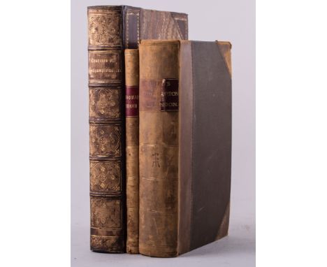
1. China: Pictorial, Descriptive, and Historical. With some account of Ava and the Burmese, Siam, and Anam. H G Bohn, 1853, 1st thus. With frontis map and nearly 100 illustrations. School prize full calf binding with gilt emblem to covers, gilt decorations and aeg. Covers little rubbed; o/w VG;2. Defoe, D: Robinson Crusoe. H G Bohn, 1859, with twelve steel engraved plates after Stothard, and 70 wood engravings. School prize full calf binding with gilt emblem to covers, gilt decorations and aeg. Covers little rubbed; o/w VG (2)

Lot 177
ALMANACS:1. London Almanack for the Year of Christ: 1757-1766. 4pp each, laid down and mounted onto paper; each with a view, including: The British Museum, London Hospital, London Bridge, Black Fryars Bridge, etc. The whole bound in plain wrappers with blank papers at the end for notes(some filled-in with receipts, remedies, etc.); those for 1764-1766 loose;2. Almanach Historique, Geographique, Genealogique, de Voyage, des Arts & des Sciences Pour L’annee 1760. Amsterdam, chez Etienne Esveldt, nd(1760). With two folding hand-coloured maps; pp200. Contemporary full mottled calf with gilt floral decoration and sail boat to covers; edges of one map little frayed; worm holes to bottom margin of last few pages (away from text); lacking front blank endpaper (2)

Lot 7
ATLASES:1. Lewis, Samuel: Topographical Dictionary of England (Atlas volume only). With Map of England, plan of London. Plus: 43 county maps, all hand-coloured in outline and some folding. 4to., original cloth; VG;2. Johnston, A K: The Royal Atlas of Modern Geography. William Blackwood, 1874, new edn. 48 fine double-page maps coloured in outline (including 8 of The Americas.) Folio, half leather; binding loose;3. Butler, S: An Atlas of Modern Geography. Longman, Rees, nd, c.1850’s. With 23 double-page maps, hand-coloured in outline. Half leather; front cover detached; a number of maps with tears to folds (and repairs) (3)

Lot 58
PROOF COPIES:1. Hemingway, E: Islands in the Stream. Collins, 1970, 1st edn. original plain wrappers and with dw (£2.) 40s. net, proof copy (Precedes US edn.); map front endpapers; dw worn and torn; o/w G+;2. Zusak, M: The Book Thief. Free uncorrected proof copy (stated on front cover); Doubleday & Bodley Head, 2007, 1st issue with full set of numbers: 1-10. pp584; G+;3. King, S: The Darker Tower: The Gun Slinger. Sphere books, 1988, 1st thus, uncorrected proof copy, not for sale; Fine (3)


Lot 127
GROSE, Francis:1. The Antiquities of Scotland: in two volumes. Hooper, 1789-1791, 1st edns. 4to. Engraved pictorial titles, plates and folding engraved map. Half leather over marbled boards; some offsetting and occasional foxing; o/w G+;2. The Antiquities of England and Wales, two volumes. Hooper, 1773-1774, 1st edns. Large 4to. Engraved pictorial titles, plates and folding engraved map. Contemporary full leather; little rubbed; occasional foxing; o/w G+ (4)


Lot 105
ESSEX:1. Transactions of the Essex Archaeological Society,Fourteen volumes: vol. 3 to vol. 16 (new series); 1889-1923. With maps, plates and illustrations. Half leather. Covers little scuffed; o/w VG; and2. Wright, Thomas: History and Topography of The County Of Essex, In two volumes. L, Virtue, 1831. Complete with a hand coloured map and all the plates on India paper. Contemporary full leather, rebacked with the original spines; extra notes and newspaper cuttings bound in. Occasional foxing and the odd small stain; o/w VG set (16)

Lot 128
BRITISH TOPOGRAPHY/PLATE BOOKS:1. Virtue’s Picturesque Beauties of Great Britain. In a series of views: 2 volumes bound in 1: Kent & Essex. Virtue, 1828; pp130; and 96; with a folding map and plates to each work. Contemporary half leather; rubbed; occasional browning and foxing; o/w G+;2. Cary’s New Itinerary: or, an accurate delineation of the Great Roads. 1806, 3rd edn. Pp918(including adverts); plus a large folding map; torn (without loss); original boards; G+;3. Walker, G G: Historical Notes on the Parish of Partney, Lincolnshire. Spilsby, 1898, 1st illustration. Original cloth gilt; G+;4. Rawsley, H D: Sonnets round the Coast. 1887; pp244, white paper covered boards; G (4)


Lot 166
RUSSEL, W A:A New and Authentic History of England, from the most remote period of genuine historical evidence, to the present important crisis,Printed for J Cooke at Shakespeare's-Head, 1777. Illustrated with 3 maps and 98 plates. Folio, pp(iv)title-page and preface, 872, (iv) subscribers’ list, etc. Contemporary full reverse calf; covers detached; one map a little frayed at edges; the odd small stain; o/w G+


Lot 118
FOUR WORKS FROM HIS MAJESTY’S YACHT ALEXANDRA:Handbook of Travellers in South Wales, 1890,Revised edn. with a map in pocket; handbook of the Isle of Wight, 1898, 5th edn. with a map in pocket; handbook of Warwickshire, 1899, with 8 plans and 2 maps (in pocket), complete; handbook of Berkshire, 1902, with 2 plans and 3 maps (in pocket), complete. All four works are bound in matching full leather with ‘His Majesty’s Yacht Alexandra’ to front covers; all with a certain amount of damp damage (4)

Lot 108
LYON, Captain G F:The Private Journal of Captain G F Lyon, of HMS Hecla, During the Recent Voyage of Discovery Under Captain Parry,John Murray, 1824, 1st edn. with large folding map and 7 plates (complete). Half leather; rubbed, head of spine chipped, with small loss; some browning and offsetting; o/w G. Plus another copy, lacking the map, but all plates present (2)

Lot 106
LYON, Captain G F:A Narrative of Travels in Northern Africa, in the Years 1818, 1819 and 1820,John Murray, 1821, 1st edn. with large folding map with routes coloured and 16 of 17 hand-coloured lithographed plates after drawings by Lyon (all loose); 4to. ppxii, 283. cloth backed boards. Spine torn and covers detached; small tear to map (without loss), brown stain to paper edges of a number of pages; one plate torn and repaired; most plates are clean

Lot 129
LONDON: (with two title-pages): SMITH, J T:Antiquities of London and its Environs,Sewell et al; 1791; Pennant, Thomas: Some Account of London. Faulder, 1805, 4th edn. With folding map and 15 plates on 14 sheets (as called for); plus an extra 96 plates, dated 1791-1800 (3 coloured); in all, folding map and 111 plates (2 folding). Pp2title pages, 415, (vi)index, and plates. Contemporary full leather; covers detached; some offsetting and browning; damp stain to margin of the last 3 plates(well away from the images); o/w G+


Lot 332
John Britton, A Topographical and Historical Description of the County of Northampton, London 1809, with folding map, half calf, 8to; Architectural Notices of the Churches of Arch Deaconary of Northampton (Deaneries of Higham Ferrers and Haddon), London and Oxford 1849, half tooled morocco; and Rev Robert Isham, The Journal of Thomas Isham of Lamport in the County of Northampton, Norwich 1875, half calf, (3).


Lot 698
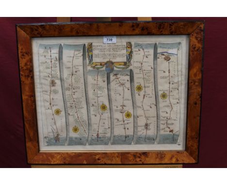
Maps: John Chapman & Peter Andre; A Map of the County of Essex from an actual survey taken in MDCCLXXII: LXXIII and MDCCLXXIV, published August 1833 by Chalk, Meggy & Chalk, Chelmsford, folio size, with twenty-six double page sheets including engraved frontispiece, key map and list of subscribers, in red leather binding with tooled gilt title to the spine CONDITION REPORT Original cloth binding is deteriorated, corners scuffed and bent, tears in binding on spine. Contents have been rebound within new end papers, a degree of foxing and time-staining throughout. Pages and images largely intact with a few slight tears to edges


Lot 3808
COMMEMORATIVE MEDALS, ART MEDALS, French Africa, Bronze Medals (2), by Emile Monier, Senegal, facing bust of Senegalese woman, rev map of Senegal, two children and a carved wooden crocodile, 58mm; and Mauritanie, bust of North African man left, rev map and costal fortress, 58mm. Both extremely fine. (2)
-
109198 item(s)/page