We found 109182 price guide item(s) matching your search
There are 109182 lots that match your search criteria. Subscribe now to get instant access to the full price guide service.
Click here to subscribe- List
- Grid
-
109182 item(s)/page


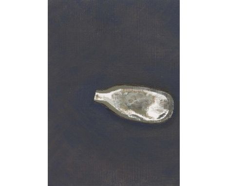
Lot 118
Andrew Torr NOX (LAT 51.4304 LON-0.1359), 2020 Oil on card Signed verso 15 x 10cm (5¾ x 3¾ in.) Andrew Torr lives and works in London. The recent subject and focus of his work are the city's open spaces at night. He is currently represented by the Northcote Gallery. These little, life-size, paintings began as a response to the vast amount of nitrous oxide bottles we see littering the streets and parks recently. The bottles are painted with as few marks as possible. The white areas are usually bare, primed canvas. This seems fitting - nitrous induces a very quick high and the bottles are discarded without a thought - it makes sense that these paintings are executed quickly. The titles come from the latitude and longitude that the bottle was found. These numbers can be entered into smart phone mapping and they will reveal where the bottle was discarded. It would be possible to map the positions of all these paintings which will trace Torr's own journey over the last few months. As with Torr's discarded beer can paintings, these studies are concerned with furtive activity and unknowable stories in the city. Coincidentally, they also share the same problems of rendering shiny, reflective surfaces - a great exercise for a painter.
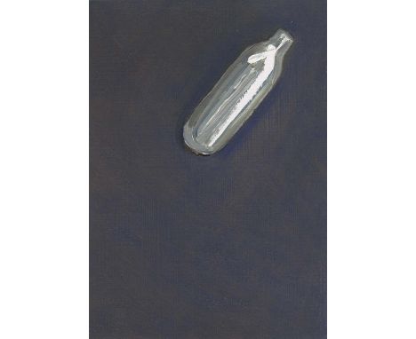
Lot 119
Andrew Torr NOX (LAT 51.4304 LON-0.1370), 2020 Oil on Card Signed verso 15 x 10cm (5¾ x 3¾ in.) Andrew Torr lives and works in London. The recent subject and focus of his work are the city's open spaces at night. He is currently represented by the Northcote Gallery. These little, life-size, paintings began as a response to the vast amount of nitrous oxide bottles we see littering the streets and parks recently. The bottles are painted with as few marks as possible. The white areas are usually bare, primed canvas. This seems fitting - nitrous induces a very quick high and the bottles are discarded without a thought - it makes sense that these paintings are executed quickly. The titles come from the latitude and longitude that the bottle was found. These numbers can be entered into smart phone mapping and they will reveal where the bottle was discarded. It would be possible to map the positions of all these paintings which will trace Torr's own journey over the last few months. As with Torr's discarded beer can paintings, these studies are concerned with furtive activity and unknowable stories in the city. Coincidentally, they also share the same problems of rendering shiny, reflective surfaces - a great exercise for a painter.
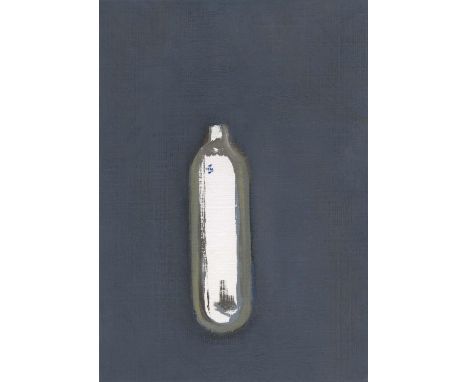
Lot 120
Andrew Torr NOX (LAT 51.4342 LON-0.1394), 2020 Oil on Card Signed verso 15 x 10cm (5¾ x 3¾ in.) Andrew Torr lives and works in London. The recent subject and focus of his work are the city's open spaces at night. He is currently represented by the Northcote Gallery. These little, life-size, paintings began as a response to the vast amount of nitrous oxide bottles we see littering the streets and parks recently. The bottles are painted with as few marks as possible. The white areas are usually bare, primed canvas. This seems fitting - nitrous induces a very quick high and the bottles are discarded without a thought - it makes sense that these paintings are executed quickly. The titles come from the latitude and longitude that the bottle was found. These numbers can be entered into smart phone mapping and they will reveal where the bottle was discarded. It would be possible to map the positions of all these paintings which will trace Torr's own journey over the last few months. As with Torr's discarded beer can paintings, these studies are concerned with furtive activity and unknowable stories in the city. Coincidentally, they also share the same problems of rendering shiny, reflective surfaces - a great exercise for a painter.
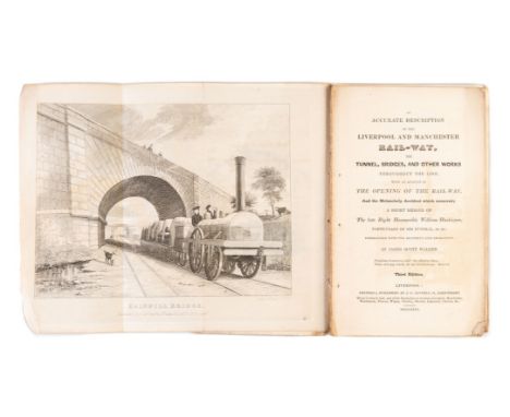
Lot 100
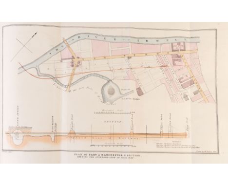
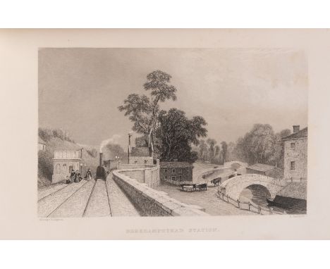
Walker (James Scott) An Accurate Description of the Liverpool and Manchester Rail-way..., third edition, 2 folding engraved plates by I.Shaw of Rainhill Bridge and Olive Mount, 16pp.advertisements at end, stitched in original printed wrappers, a little soiled and frayed at edges, wrappers detached with frontispiece, Liverpool, 1831 § Booth (Henry) An Account of the Liverpool and Manchester Railway, first issue, lithographed frontispiece, folding cross-section of the line (annotated) and a plate showing 'Rocket' and 'Novelty', presentation copy from the author inscribed to Mr Dixon on front free endpaper, ink stain to fore-edge of last few leaves, modern half red morocco, Liverpool, [1830]; another edition, second, larger format issue with folding map, lithographed frontispiece, plate and folding cross-section, contemporary ink signature of John Temperley to head of title, bookplate of Arthur Elton, modern half calf, Liverpool, [after 1833]; and a modern facsimile of Shaw's Views...of the Liverpool and Manchester Railway, 8vo & 4to (4)⁂ The first is generally regarded as the first railway guidebook. The first edition of 1830 had a map, the second a map and a plate, the third edition was considerably expanded, but the map dropped. The frontispiece shows a Stephenson engine of the Planet type. The Liverpool Manchester railway was the first to offer both passenger (No Smoking only) and freight.Henry Booth was Treasurer of the Liverpool and Manchester Railway. The larger format second issue of his work includes a map showing branch lines including the St. Helens Widnes line which was not built until 1833, the larger format was needed to avoid an horizontal fold on the map. This copy was owed by the railway engineer John Timperley, the first recipient of the Telford medal.
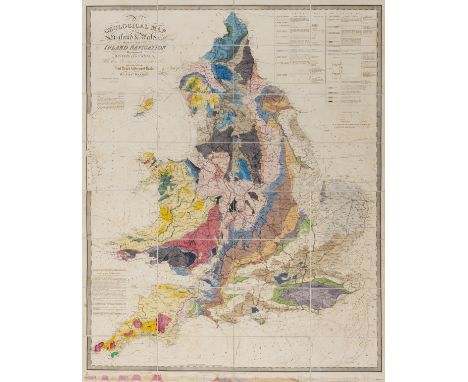
Lot 101
Walker (J. & C.) A Geological Map of England and Wales, showing also the Inland Navigation by means of Rivers & Canals, with their Elevation in feet above the Sea, later issue, large folding hand-coloured engraved map, c.1280 x 1040 mm., dissected and mounted on linen with green endpapers, some light offsetting, folding into original dark green cloth slip-case with pull-off top, red morocco label, rubbed, spine a little faded, 8vo, [c.1862].⁂ A handsome map in good condition, originally issued in 1835. The colourist depicting the rail routes seems to have taken a few liberties and omitted some of Cumbrian network. The line to Truro is shown complete therefore dating the colourist's efforts to the beginning of the 1860s.

Lot 103
Weinthal (Leo) The Story of the Cape to Cairo Railway and River Route, from 1887 to 1822, 3 volumes plus map and index volume, together 4 volumes (without the rare separately-published vol.5 supplement), maps, plates and illustrations, some mounted photographs, 12 folding maps in pocket in index volume, original half morocco, spines gilt, [Mendelssohn IV, pp.743-744], 4to, 1923-1925.
Lot 107
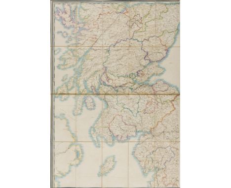
Wyld (James) Railway Map of England, Wales and Scotland...shewing the Lines of Railways with their Stations...the Inland Navigation, Great and Cross Roads, Cities, Market Towns & Villages, ?first issue, large folding hand-coloured engraved map in 4 parts, overall c.2060 x 1240 mm., dissected and mounted on linen with marbled endpapers, some light offsetting, folding into original cloth slip-case, printed label to upper cover (chipped), rubbed and faded, splits to joints, 8vo, Wyld, [pre-1847]].⁂ With the Central Scottish Railway to Perth marked as a prospect, and no marking for the Alloa branch. The Lancaster Carlisle line completed in 1847 is also shown as incomplete.
Lot 108
Wyld (James) Railway Map of England, Wales and Scotland..., ?second issue, large folding hand-coloured engraved map in 2 parts, overall c.2060 x 1240 mm., dissected and mounted on linen with cloth endpapers, some light offsetting, folding into original cloth slip-case, printed label to upper cover, rubbed and a little stained, splits to joints, 8vo, Wyld, [c.1855].⁂ This edition in rather stronger colour than the previous lot, and including the Central Scottish Railway to Perth with a branch to Alloa.

Lot 11
Bradshaw (George) Bradshaw's Railway Companion, folding map with route in red, 13 double-page maps/plans, some partly hand-coloured, original brownish cloth, glazed green label to upper cover, 1843; another edition, 2 folding maps, 14 double-page maps/plans, some partly hand-coloured, folding cross-section, original brownish cloth, glazed green label to upper cover, 1845; Lengths and Levels to Bradshaw's Maps of the Canals, Navigable Rivers, and Railways, in the Principal part of England, first edition, 1833; Lengths and Levels...from Actual Survey, 2 engraved maps on folding sheet, 1832 bound with Extracts from the Minutes of Evidence given before the House of Lords on the London and Birmingham Railway Bill, half-title, folding engraved map of Stephenson's survey, 1832, together 3 works in 1 vol., contemporary cloth, spine faded; Bradshaw's Shareholder's Guide, Railway Manual and Directory, for 1856, 2 large folding maps with plates of patented inventions on verso, one torn, contemporary maroon morocco with brass clasp, title and "G.Gamble Esq." in gilt to upper cover, spine gilt, remains of old label to head, rubbed, London & Manchester, 1856; Bradshaw's British Railway Guide..., No.182, folding map, illustrated advertisements, original printed wrappers, spotted, upper cover frayed and detached, 3rd Mo (March) 1849; and 13 others, Bradshaw, v.s. (18)⁂ The Lengths and Levels are often found bound together with the Extracts of Minutes. The London to Birmingham Company had their original Bill refused after several nimby peers objected. However, in 1833 the Bill was passed and work started later that year, by 1838 it was complete. The journey took five and a half hours.

Lot 112
America.- The American Revolution.- Howell (Reading) A Map of the State of Pennsylvania by Reading Howell, MDCCXCII To Thomas Mifflin Governor ... This Map is respectfully Inscribed by the Author, showing exact boundaries, including the western limits, from information Howell gathered from surveys made after the Revolutionary War, with numerous topographical details, towns, and roads, engraving, a good impression, 960 x 1630 mm (37 3/4 x 64 in), dissected and mounted on linen, some splitting to linen, a few edges curling, some spotting, browning and surface dirt, folding without slip-case, 4to, published 1 August 1792, for the Author, & Sold by James Phillips, George Yard, Lombard Street, London, 1792.⁂ "The best map of Pennsylvania to appear in the 18th century, and the first detailed map of the State to show its exact boundaries"(Wheat and Brun)
Lot 128
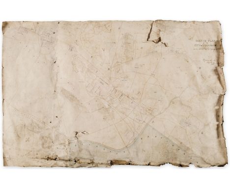
India.- Royal Bengal Engineers.- Sketch Plan of the City of Lucknow, large manuscript map of the capital of the state of Uttar Pradesh, pen and inks, watercolour wash, traces of pencil, on wove paper, sheet approx. 660 x 1000 mm (26 x 39 1/2 in), with owner's ink inscription of William Crommelin in the upper right corner, mounted on linen, several large tears within the map with some losses, numerous nicks and tears to extremities, surface dirt, damp-stains, unframed, [circa 1860]; together with a lithographed map by H.M Smith, No. 2 Plan of the Operations Against Lucknow during the month of March 1858, mounted on various [?]Indian handmade papers, old folds, some surface abrasion and adhesive issues, damp-stains and the lower right affixed with old paper obscuring the map, in general poor condition with numerous issues, unframed, published by Surveyor Generals Office Calcutta, 1858 (2)⁂ The manuscript map bears the collectors' signature of Major William Arden Crommelin, of the Bengal Engineers, later Chief Engineer of Oudh.
Lot 129
India.- Topographical Department (War Office) Plan of Lucknow, plotted from a survey made in 1856, by Lieut. Moorsom, 52nd. Lt. Infantry, lithograph with hand-colouring, 980 x 690 mm (38 3/4 x 27 1/4 in), dissected and mounted on linen, minor offsetting and browning, folding into red straight-grain morocco by 'Wickwar Binder London', gilt, upper cover decorated with Royal coat of arms and lettered 'Plan of Lucknow, some rubbing and minor scuffs, 8vo, 1856 ⁂ Fine copy of this scarce map produced a year or so before the start of the Great Mutiny of 1857.

Lot 130
Italy.- Swinburne (Henry) Travels in the Two Sicilies, 2 vol., first edition, half-title in vol.2 only, folding engraved map, 2 plans, 20 plates (2 folding) and one folding letterpress genealogical table, some foxing, short tear to map, bookplate of James Frampton, contemporary tree calf, gilt, a little rubbed and scratched but overall a very handsome copy, 4to, 1783-85.
Lot 136
NO RESERVE Mediterranean.- Willyams (Cooper) A Voyage up the Mediterranean in His Majesty's Ship the Swiftsure, first edition, large paper copy, engraved dedication, sepia aquatint map of the Mediterranean, plan of the Battle of the Nile and 40 plates, ex-library copy with ink numbers to verso of title and dedication and blind-stamps (inoffensive), mostly marginal but within image of around 18 plates, else generally clean with some occasional spotting or light staining, small repair to inner margin of title, modern half calf, gilt, spine in compartments and with earlier morocco label, [Abbey, Travel, 196; Blackmer 1813], folio (475 x 323mm.), Printed by T. Bensley for J. White, 1802.⁂ In 1798 Willyams served as chaplain of the Swiftsure, a ship in the squadron under the command of Nelson. He was present at the Battle of the Nile and according to DNB his is 'the first, the most particular, and the most authentic account of the battle'. Includes views of Sicily, Egypt and Gibraltar. Provenance: Col. Samuel Barrett Miles, presented by his wife to Bath Public Library, 1920 (bookplate). Miles was a British Army officer, diplomat, and author of The Countries and Tribes of the Persian Gulf, and several papers published by the RGS.

Lot 151
Russia.- Lyall (Robert) The Character of the Russians, and a detailed History of Moscow, first edition, half-title, hand-coloured aquatint frontispiece and 22 plates, of which 12 are hand-coloured aquatints and 4 are folding, folding engraved map, some foxing and offsetting, ink library stamp to plate versos and a few text margins, modern diced half calf, spine gilt, [Abbey, Travel 227], 4to, 1823.⁂ An important work, which includes a fine folding panoramic view of the Kremlin from the river Moskva, a catalogue of local plants, an essay on Russian architecture and an account of Napoleon's burning of Moscow in 1814.

Lot 155
Switzerland.- George (H.B.) The Oberland and its Glaciers, first edition, 28 mounted photographs by Ernest Edwards, double-page lithographed map, half-title, front endpapers and all to p. 22 corners water-stained, foxing and creasing, contemporary gilt pictorial morocco de-luxe binding, slightly rubbed, marked and dulled, gilt panelled spine, g.e., [Neate G13; Perret 1884], 4to, 1866.
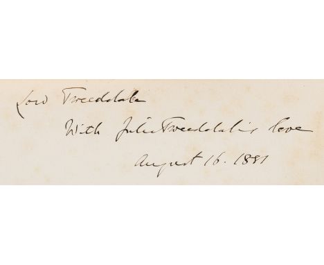
Lot 164
Birds.- Hay (Arthur, 9th Marquis of Tweeddale) The Ornithological Works ... reprinted from the Originals by the Desire of his Widow, first edition, presentation inscription by Julia Tweeddale to half-title, portrait frontispiece, hand-coloured map and 11 hand-coloured plates, occasional faint spotting, bookplate, contemporary half-morocco, a little rubbed, 4to, [Zimmer p.293; Anker 513; Wood p.605], 1881.⁂ Provenance: Ink inscription signed Julia Tweeddale, and dated 1881, to half-title. Bookplate of William Montagu Hay, the 10th Marquess. This copy contains the full complement of plates called for in the 'Philippine Archipelago'. Copies are also recorded with no colour plates (Wood) or 22 (Anker and Nissen).

Lot 172
Hunting.- Chapman (Abel) On Safari: Big-Game Hunting in British East Africa, frontispiece, original pictorial cloth, a little rubbed, [Hosken p.45], 1908; Savage Sudan, frontispiece map, original pictorial cloth, rubbed, [Czech p.35], 1921; Wild Norway, frontispiece, previous owner's signatures, publisher's advertisements at end, original cloth, 1897, first editions, plates and illustrations, occasional spotting, slight bumping to corners and extremities; and 11 others by the same, most first editions, 8vo (14)

Lot 175
Tweedie (Major-General W.) The Arabian Horse, His Country and People, first edition, presentation copy signed by the author on front free endpaper, plates, some colour, illustrations, folding map in pocket at end, pp.257/258 and 263/264 misbound, handsomely bound in green morocco, gilt, by the Chelsea Bindery, with horse's head vignette to upper cover and palm trees to spine, g.e., 4to, Edinburgh & London, 1894.⁂ Inscribed by the author to Sir Alfred Lyall in the year of publication; also with Lyall's ownership inscription and tipped-in printed leaf of verse by him entitled 'A Hard Bargain' about the sale of an Arab horse.
Lot 177
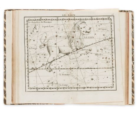
Flamsteed (John) Atlas Celeste de Flamsteed, approuve par l'Academie Royale des Sciences, second edition, edited by J. Fortin, 30 double-page engraved celestial maps, 40pp. star catalogue at end, additional double-page manuscript celestial map bound in, minor spotting and soiling, ink name of George Sloggett on title, modern morocco-backed boards, 4to, Paris, F.G. Deschamps, chez l'Auteur, 1776.

Lot 21
Chalmers (James) The Channel Railway, connecting England & France, first edition, lithographed title, folding map and large folding plate, modern half dark maroon morocco, g.e., 1861; another edition, second edition, large folding plate (torn but no loss), newspaper cuttings on channel tunnel schemes loosely inserted, original cloth, slightly rubbed and faded, 1867.⁂ Serious proposals for a fixed cross-Channel communication were first broached at the end of the 18th century but were deferred because of the Napoleonic wars. Several different proposals were made throughout the remainder of the 19th century. This crackpot scheme proposed submerging a tube and anchoring it with baskets of rocks etc. Chalmers claimed the project would cost £12,000,000 but would return £1,215,000 per annum thereafter. An enormous mid-channel lighthouse/ventilation shaft was central to the proposition. In the second edition, reissued seven years after the first, Chalmers tries to bolster his credentials with other successful but unrewarded engineering exploits, and the encouragement from R. Cobden. This time he proposes a twin-tubed tunnel.
Lot 233
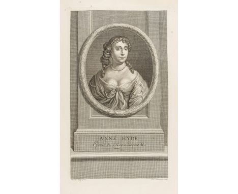
Jacobitism.- The Tryals of William Ireland, Thomas Pickering, and John Grove, for Conspiring to Murder the King, imprimatur leaf corner torn with slight loss, last f. torn and repaired, browned, disbound, Alistair Cooke's copy with his bookplate on pastedown of modern portfolio, [Wing T2268], Robert Pawlet, 1678 § Henderson (Andrew) The History of the Rebellion, MDCCXLV and MDCCXLVI, The Fifth Edition, browned, ink signature of J. Hyde at head of title, new endpapers, contemporary calf, slightly rubbed, corners worn, rebacked retaining the original label, for A. Millar, W. Owen, W. Reeve, and J. Swan, 1753 § Johnstone (James, Chevalier De) Memoirs of the Rebellion in 1745 and 1746, first edition, 3 engraved portraits and a map, title slightly offset, some foxing, modern bookplate, contemporary calf, gilt borders, slightly rubbed, rebacked in modern calf, 1820; and 18 others, Jacobitism, including an engraved portrait of Anne Hyde, v.s., v.d. (22).
Lot 254
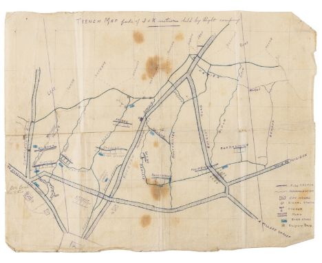
First World War.- Money (M.B., Private, later Corporal, Ox & Bucks Light Infantry, British Expeditionary Force, fl. 1915-18) Collection of material relating to the First World War, including: 3 maps of Hebuterne (1 a Trench map), notebook (disposition of grenades, "Mechanism of the Lewis Gun" etc.) and others, maps, foxed and browned, folds, notebook c. 65pp. (many pp. in shorthand), in pen and pencil, some ff. loose, others working loose, original leather, v.s., v.d., 1915-18 (8 pieces).⁂ Scene of the Battle of Hébuterne, which took place from 7 to 13 June 1915 on the Western Front in Picardy.

Lot 26
Cumming (T.G.) Illustrations of the Origin and Progress of Rail and Tram Roads, and Steam Carriages, 64pp., engraved frontispiece and plate, Denbigh, for the Author, 1824 bound with Specification of John Birkinshaw's Patent, for an Improvement in the Construction of Malleable Iron Rails..., 22pp., large folding engraved plate, Newcastle, 1824 and Rennie (George) the Preliminary Report on the Bridlington and York Railway, 16pp., folding lithographed map, York, 1834 and Chapman (William) Observations on the most advisable measures to be adopted...for the Transit of Merchandise...to or from Newcastle and Carlisle..., 10pp., Newcastle, 1824 and Medhurst (George) A New System of Inland Conveyance, for Goods and Passengers..., 38pp., half-title, 5 lithographed plates, appendix of catalogue of Medhurst's Patent Scales with folding engraved plate, advertisement leaf, 1827 and Thoughts on Railways, and Projected Railways, By Observer, 15pp., Liverpool, 1833, together 6 works in 1 vol., first editions, George Rennie's copies with his signature/inscription to title of the first and last and half-title of the fifth, trimmed, bound in modern half dark maroon morocco, g.e., spine a little faded, 8vo ⁂ Sammelband of early railway pamphlets belonging to one of the principal figures. George Rennie (1791-1866), civil engineer, brother to and partner of Sir John Rennie. They collaborated with Stephenson on the Liverpool Manchester railway and built engines for the London to Croydon line in 1838-9.
Lot 31
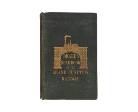
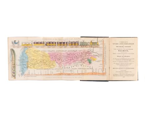
Drake (James) Drake's Road Book of the Grand Junction Railway, second edition, with folding hand-coloured engraved map but without the optional plates, folding table of distances, [1838]; Drake's Road Book of the London and Birmingham Railway, folding hand-coloured engraved map, folding table of distances, 3 engraved advertisements, [1839] § Roscoe (Thomas) The Book of the Grand Junction Railway, additional engraved vignette title, folding hand-coloured engraved map, engraved plates, [1839], all original cloth, gilt, the first two pictorial, a little rubbed; and 2 others by Roscoe, 8vo (5)
Lot 314
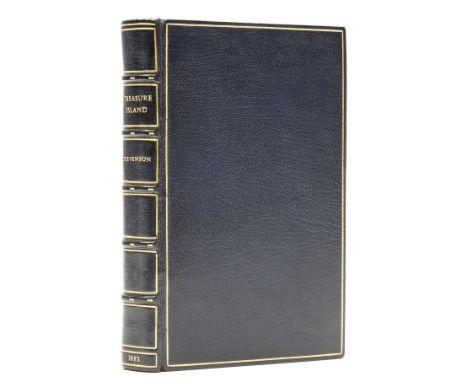
Stevenson (Robert Louis) Treasure Island, first edition, half-title, map frontispiece, 8pp. advertisements dated 12.83, modern blue morocco, gilt, by Henry Sotheran, g.e., cloth slip-case, 8vo, 1883.⁂ Handsome copy with the following early issue points (though with later advertisements): "dead man's chest" on p.2 and p.7 not capitalised; "rain" for "vain" in last line p.40; "a" not present in line 6, p.63; "7" is missing from pagination on p.127; full-sop is missing after "opportunity" in line 20, p.178; "worse" for "worst" in line 3, p.197.
Lot 32
Dredge (James) The Pennsylvania Railroad: Its Organization, Construction and Management...chiefly reproduced from "Engineering", folding colour map, 82 plates, many double-page, bookplate of J.J.Haut, contemporary half morocco, rubbed, 1879 § Dare (Charles P.) Philadelphia, Wilmington and Baltimore Railroad Guide, first edition, wood-engraved frontispiece, 4 folding maps, illustrations, advertisements at end, light foxing, modern half dark maroon morocco, Philadelphia, 1856; and another American guide, 4to & 8vo (3)
Lot 329
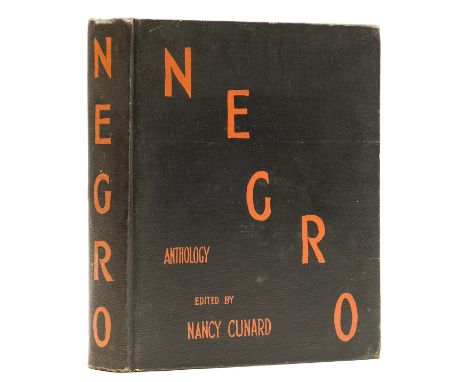
Cunard (Nancy) Negro: Anthology...1931-1933, first edition, signed by Cunard and dated May 1942 on pastedown, folding colour map, numerous photographic illustrations, flier loosely inserted, endpapers a little spotted, original second issue cloth blocked in red with map of the Black Belt of America on lower cover, corners a little bumped, extremities a little rubbed, otherwise excellent, 4to, 1934⁂ Cunard's landmark work on African-American history and culture, rare signed. Includes Cunard's flier stating her intentions to publish a "new book on colour [that] comprises what is Negro and descended from Negro" which gives a putative publication date of 1932 or 1933. Printed in an edition of 1000 copies but apparently a large number of unsold copies were destroyed in the Blitz. Contributors include Ezra Pound, Samuel Beckett, Norman Douglas, Langston Hughes, W. C. Williams and Theodore Dreiser.
![Early Railways.- [Beginning of the World's Railways (The): Pictorial Engravings], an album of over 200 prints etc. relating t](https://cdn.globalauctionplatform.com/9a20ae7e-ffba-4e42-a051-ac5d00aaac37/2152a12f-23b7-4bb3-bbc9-ac60010fcd7f/468x382.jpg)
Lot 33
Early Railways.- [Beginning of the World's Railways (The): Pictorial Engravings], an album of over 200 prints etc. relating to railways on c.100 sheets including 3 original watercolours, engravings, a few with aquatint, lithographs, some tinted or chromolithographed, woodcuts, wood-engravings, a music sheet and 2 French games, some hand-coloured, one or two double-page, most trimmed close to plate-mark and mounted or tipped into blank leaves, occasional spotting or soiling, mostly marginal, modern half dark maroon morocco, t.e.g., large folio, v.d.⁂ Including:1. Locomotive Engine & Train...Birmingham & Liverpool Rail Road, hand-coloured aquatint after Bourne, c.200 x 600mm., 18252. View of the Railway from Hetton Colliery, hand-coloured lithograph after Bouvier, c.440 x 740mm., n.d.3. View of a Train of Carriages drawn by a Locomotive Steam Engine..., hand-coloured lithograph after Vignoles, c.220 x 550mm., n.d.4. Viaduct over the Sankey Canal and Valley, lithograph by Wm.Smoult, c.500 x 730mm., n.d.5. View of the Manchester & Liverpool Railway taken at Newton, hand-coloured aquatint by R.Havell after Calvert, c.300 x 380mm., [c.1825]6. Travelling on the Liverpool and Manchester Railway, a pair of double views, hand-coloured aquatints by S.G.Hughes after I.Shaw, c.250 x 660mm., tears to lower edge slightly extending into images, Ackermann, 18337. View of Newark, N.J., tinted lithograph by E.Whitefield after F.Michelin with 4 smaller views below, c.500 x 940mm., some tears, New York, 18478. Osborne's Map of the Grand Junction Railway, engraving by D.Smith, c.330 x 600mm., Birmingham, n.d.9. Fore's Contrasts, 6 hand-coloured aquatints on 3 sheets by J.Harris after Alken, c.410 x 600mm., 185210. Eröffnung der Münchner-Augsburger Eisenbahn, hand-coloured lithograph, c.250 x 380, n.d.11. Stummer (Josef) Bildliche Darstellung der Geschichte der ausschl: privil: Kaiser Ferdinand's Nordbahn..., title in black & gold surrounded by 8 chromolithographed views, letterpress list of plates in German, French & English, 9 plates of graphs, all but one chromolithographed and heightened with gold incorporating trains at the top, Vienna, 1855.12. Steeple Chasse Autour et a Travers le Monde, hand-coloured lithographed pictorial title heightened with gum arabic, hand-coloured double-page lithographed game incorporating map of the world and rules in French & English at centre and vignettes in corners, Paris, Jannin, n.d.
Lot 39
Gauge Controversy.- Cundall (Joseph, editor) Pamphlets in support of National Uniformity of Gauge and the Report of Her Majesty's Gauge Commissioners collected, bound and sold by Joseph Cundall, a bound volume of 13 pamphlets by William Harding and others, title in red & black, some maps, contemporary russia, spine worn and defective, Cundall, [1846] § Sidney (Samuel) Gauge Evidence. The History and Prospects of the Railway System, first edition, folding colour map, original pictorial cloth, gilt, with elaborate border in blind, a little rubbed, spine slightly faded, 1846, 8vo (2)⁂ The Gauge wars lasted throughout the years following the 1846 Railways Act which recommended the adoption of the narrow gauge. The GWR marshalled a powerful lobby defending Brunel's broad gauge. The last train to leave Paddington on the original track left in 1892. The author of the second item, Samuel Sidney, was a leading opponent of the broad gauge. The folding map shows the ten points where the GWR broad gauge met the standard narrower gauge.
Lot 434
Vue d'optiques.- Wilkinson (Robert, map and printseller, fl. 1758-1825) and others. Album of 91 original hand-coloured views of European cities and gardens, including over 25 views of London, including Vauxhall Gardens, Richmond, Twickenham, and Chiswick; two views of Windsor Castle; one of Oxford; eight views of the Earl of Temple Gardens, Buckinghamshire; one view of Stonehenge; two views of the harbour of Dublin; eight Scottish views by John Slezer; and views of Venice, Florence, Athens, Naples, Paris, including the gardens Versailles and Fontainebleau, one of Honduras, and many others, etchings and engravings, all with contemporary hand-colouring in watercolour and gouache, on various wove and laid papers, some bearing Whatman watermarks with date '1794', each sheet approx. 300 x 470 mm (11 3/4 x 18 1/2 in), numerous nicks and tears throughout, some into images, many marginal losses, surface dirt and browning throughout, lacking boards, spine remains but very worn with heavy losses, with gilt number '106' and title '[C]olour'd/ [V]ie[ws], many leaves almost loose, folio, [probably circa 1780-1800]⁂ A comprehensive collection of views, all with contemporary hand-colouring. Full list available upon request.
Lot 46
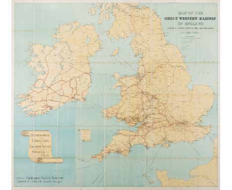
Great Western Railway. Map of the Great Western Railway of England and its connections to the British Isles, large folding colour lithographed map, c.1500 x 1800mm., dissected and mounted on linen, original cloth slip-case, a little rubbed, [c.1905]; and 6 others, GWR, including a very large folding original manuscript land plan of the Bristol Lines, v.s. (7)
Lot 48
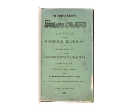
Guide (A) to the Norfolk Railway from Yarmouth to Ely..., first edition, folding lithographed map, modern half dark maroon morocco, with original printed green upper wrapper bound in (light soiled, slightly chipped at fore-edge), Norwich, Stevenson & Matchett, 1845 § Linton (John) A Handbook of the Whitehaven and Furness Railway, first edition, engraved plates, folding map at end (tear to inner edge repaired), original cloth, gilt, spine rubbed and faded, small stain to lower cover, London & Whitehaven, 1852 § Vale of Neath Railway. Rules and Regulations, third edition, original cloth, rubbed, spine faded, Neath, 1866, 8vo (3)⁂ The Norfolk line opened in 1845, this is therefore a very rare survivor from Norfolk's first railway connection to Ely, Cambridge and London. WorldCat lists just two copies, one in America and a sole defective example in the UK.Those who worked on the Vale of Neath Railway were obliged to sign a declaration printed at the end of the Additional Instructions, which is dated 1865. The first edition of the rules was printed when the line opened 1851 and changed again in 1855. It was a Brunel-designed broad gauge line later becoming mixed gauge when a third rail was added.
Lot 49
Herapath (John) & Effingham Wilson. The Railway Magazine, First Series, 10 issues in 1 vol., 16 engraved or lithographed maps, some hand-coloured in outline and most folding (some large), and 11 engraved or lithographed plates, 6 folding, some soiling, a few tears and repairs, p.335-336 lacking and supplied in typescript, bookplate of Arthur Elton, contemporary half calf, spine worn and defective, upper cover detached, Effingham Wilson, May 1835-February 1836 § Herapath (John) The Railway Magazine, and Annals of Science, New [Second] Series, 5 vol. in 6 (Nos.I-XXXVI), 23 folding lithographed maps and plates bound in one volume, some with hand-colouring in outline, some spotting or soiling, one or two tears, Arthur Elton's set with his bookplate, contemporary half blue calf, rubbed, Wyld and Son, 1836-39; The Railway Magazine, and Steam Navigation Journal, vol.6 (Nos.XXXV-XLII), without map and illustrations as advertised on title but possibly not issued, first and last few leaves stained at inner margin and becoming loose (frayed at fore-edge), contemporary red morocco, gilt, G.A.Sekon's copy with his name in gilt to upper cover, g.e., spine slightly rubbed and faded, 1839, 8vo (8)⁂ The railway periodical takes its first confident steps, at first under the joint editorship of the physicist Herapath and Wilson. The lot includes a complete run of the periodical in its second guise, running from March 1836 to February 1839 when it became the Railway Magazine and Steam Navigation Journal, with Herapath taking overall editorship. All are a mine of information during this period of intense railway mania, including many important railway maps of the various intended and completed lines throughout the UK and interesting articles with extensive working diagrams for the Pinkus pneumatic system, and a proposal with a folding map for an Indian railway between Calcutta and Saugur on the coast. Despite the relatively austere tone of this scientific journal a few flights of fancy sometimes intrude: "...Let the reader fancy himself flying over the country at the rate of 120 or 140 miles an hour, or starting from Edinburgh at five in the morning and being comfortably seated at breakfast in London at half past eight...".
Lot 51
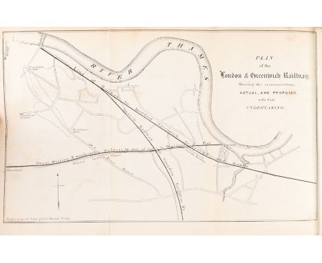
Hill (David Octavius) Views of the Opening of the Glasgow and Garnkirk Railway, also, An Account of that and other Railways in Lanarkshire. Drawn up by George Buchanan, Esq., Civil Engineer, first edition, engraving of locomotive on verso of title, 4 superb lithographed plates by Hill, lithographed map at end, Lanarkshire Railways section with 7 lithographed illustrations on india paper mounted in text, erratum slip tipped in at p.9, plates very slightly creased and frayed at edges, text and map with very light foxing, short insect track to lower margin of plates repaired, later half red morocco, spine gilt, original grey printed wrappers bound in, boards slightly rubbed and stained, rubbed at edges, [Abbey, Life 403, coloured copy], large oblong folio, Edinburgh, Alexander Hill, 1832.⁂ Scarce work rarely found complete and with the original wrappers, with superb lithographed plates by the Scottish landscape painter and early photographer. It depicts an early railway mainly for the transport of coal, at first using horse power but quickly adapting to steam using an early Stephenson Planet type engine. On the opening day "the one engine, the St Rollox, conveyed the directors and a number of ladies and gentlemen, to the amount in all of nearly 200; the other, the George Stephenson, drew a train of thirty-two waggons loaded with coal...". (p.8) "The book was issued plain and coloured, and can be claimed as one of the rarest and most attractive of railway items". (Abbey)
Lot 53
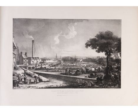
House of Commons. Proceedings...on the Liverpool and Manchester Railroad Bill. Sessions 1825, 11 hand-coloured lithograph plans only (of 12, lacking a map of Manchester), most folding, folding engraved view of Black Brook House (a villa endangered by the railway), 2 folding warehouse plans, errata slip, modern half dark maroon morocco, t.e.g., others uncut, spine a little faded, folio, 1825.⁂ The Liverpool & Manchester railway was the first intended for passenger as well as goods traffic. The establishment forces of peers and vested turnpike interests combined to defeat this bill, and in so doing George Stephenson was to some extent damaged by the severe grilling he received under cross examination. Issues of access, denied to him by dissenting landowners, led to the submission of inaccurate surveys; these and other matters led to the bill's downfall. The Company reassigned the survey to George Rennie and his brother, and the bill, with a few changes mollifying the noble landlords, achieved Royal Assent in 1826. The company then took no time, to Rennie's chagrin, in reappointing Stephenson as the engineer to build the line.
Lot 62
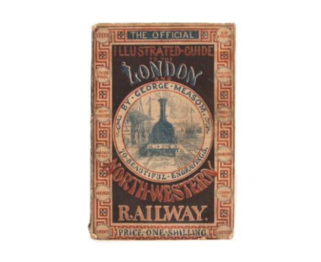
Measom (George) The Official Illustrated Guide to the London and North-Western Railway, first edition, wood-engraved frontispiece and illustrations,numerous advertisements, original pictorial wrappers, a little rubbed and soiled, corners slightly frayed but a good copy, preserved in modern half dark maroon morocco, spine faded, 1856; The Official Illustrated Guide to the Brighton and South Coast Railways and their Branches, wood-engraved frontispiece and illustrations, contemporary half morocco, rubbed, [c.1851-2]; and a map of the London Brighton and South Coast Railway of c.1884, 8vo (3)⁂ The first is the one shilling (?now preferable) printed wrapper version, for 2s. it came in cloth with gilt edges. A rare survivor, by 1864 it had grown to 723 pages, and it stayed in print for over fifty years. There were various editions of the second work dated 1852, '53 & '54. This undated edition does not have the folding plate or map seen in others.
Lot 63
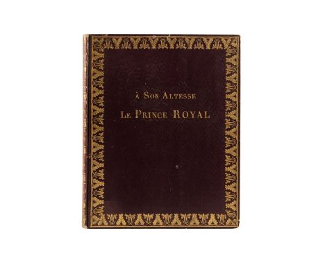
Moreau (P.) Description Raisonnée et Vues Pittoresques du Chemin de Fer de Liverpool a Manchester, edited by Auguste Notré, first edition, half-title, folding engraved map, 2 folding engraved plates of rails and locomotives and 9 engraved views by Ollivier on india paper and mounted, light foxing, bookplate of J.J.Haut, handsome contemporary dark maroon boards with elaborate foliate border in gilt and "A Son Altesse Le Prince Royal" to upper cover, spine gilt, uncut, a little rubbed, spine faded, 4to, Paris, 1831. ⁂ A lovely copy of this attractive book, which demonstrates how quickly British advances in railway science were appreciated on the continent. This copy with a bold inscription to the popular Prince Royal, the young and dashing Ferdinand-Philippe d'Orléans.
Lot 66
Parry (Edward) Railway Companion from Chester to Shrewsbury, first edition, large folding engraved map (torn), 10pp. advertisements, Chester, 1849; Parry's Railway Companion from Chester to Holyhead, first edition, folding map, 26pp. advertisements, 1848 § Cornish (J. & S.) Cornish's Guide and Companion to the Grand Junction and the Liverpool and Manchester Railways, third edition, folding hand-coloured map, folding table, 40pp. advertisements, 1838 § Sidney (Samuel) Rides on Railways leading to the Lake & Mountain Districts of Cumberland, North Wales..., first edition, folding map, 24 plates, 6pp. advertisements, [1851], all original cloth, a little rubbed and faded, 8vo et infra (4)

Lot 68
Philp (R.Kemp) London Chatham & Dover Railway Panoramic Guide; South Eastern...; London Brighton and South Coast...; London and South Western...; Midland..., together 5 works in 1 vol., each with folding map, illustrations, contemporary cloth, a little rubbed, with all printed yellow wrappers and advertisements bound in, folio, [1874-76].⁂ These guides, which are in excellent condition, follow the usual form with sights to be seen along the way, but the author maintains a jocund tone eg. " the public gardens wherein presumably Cupid is the principal archer...".

Lot 71
Photographs.- Lord-Castle (Arthur) Photograph Album of Palestine during and after the First World War, c.100 postcard size photographs mounted on 25 leaves, a few captioned in ink on the photograph, with original manuscript map of Palestine 1916-22 drawn in ink and colours on graph paper and loosely inserted, a few photographs loose, contemporary cloth-backed boards, rubbed, small 4to, [1916-22].⁂ The collection was formed at the time by an enthusiast or professional, at one time stationed at Kantara. There are many scenes of damaged rail stock, bridges, accidents. etc. and two possibly suggesting that the collector was one of the military district engineers. After the Armistice there are several pictures of Palestine and Jerusalem in particular.
Lot 8
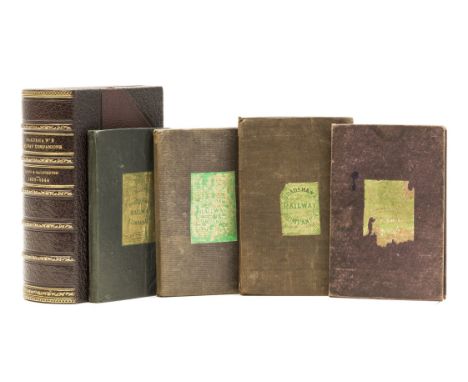
Bradshaw (George) Bradshaw's Railway Time Tables..., No.3, folding map with routes supplied in red & yellow (slightly frayed at edges), 8 double-page maps/plans, original purple cloth, 11th Mo. 18th [i.e. 18th November] 1839; Bradshaw's Railway Companion..., folding glazed map with route in red, 8 double-page maps/plans, some partly hand-coloured, folding cross-section, original greyish-purple cloth, Manchester, 7th Mo. 1st [1st July] 1840; Bradshaw's Railway Companion, 2 folding maps with routes in red and/or yellow, one glazed, 8 double-page maps/plans, some partly hand-coloured, folding cross-section, original green cloth, Manchester, 1840; Bradshaw's Railway Companion, 2 folding and 13 double-page maps/plans, some partly hand-coloured, a little stained, original greyish-purple cloth, 1844, all with green and gold glazed label to upper cover, the last a different format, the first worn and chipped, all rubbed, a few small stains, preserved together in modern half dark maroon morocco drop-front box with lid and catch, spine gilt, 24mo⁂ A good group of early Bradshaws. The first is the third issue, after those on 19th and 24th October which covered the northern and southern railways respectively. This is the first to contain both north and south.
Lot 85
Roscoe (Thomas) The London and Birmingham Railway, first edition, engraved additional vignette title and plates, folding engraved map at end dated 1838, illustrations, tissue guards, a good clean copy, contemporary half calf, rubbed, Tilt, [1838] § Hand-book (A) for Travellers along the London and Birmingham Railway, folding hand-coloured map, wood-engraved plates, advertisement leaf at end, [1839] § Midland Counties' Railway Companion (The), first edition, engraved decorative half-title folding map and 4 plates including one of Derby Station not called for, illustrations, Nottingham & Leicester, 1840, the last two modern half dark maroon morocco, g.e., spines a little faded, 8vo et infra (3)⁂ Rugby, Leicester, Nottingham and Derby became connected by the Midlands Counties' Railway, which opened for public use in the summer of 1839. Its independence was short lived, as crippled by the competitive rates of its rivals in the transportation of coal, it was more or less forced into a partnership by 1844.
Lot 9
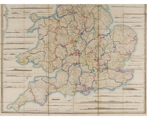
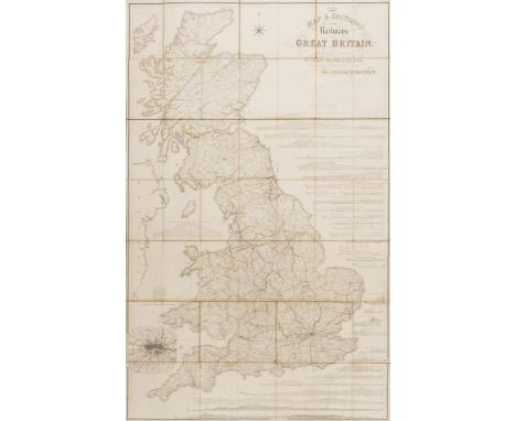
Bradshaw (George) Map & Sections of the Railways of Great Britain..., folding hand-coloured engraved map, c.1650 x1400mm, dissected and mounted on linen, some light offsetting, folding into contemporary straight-grain morocco with accompanying 31pp. 'Tables of the Gradients...' bound in at beginning, rubbed, rebacked in cloth preserving old spine (faded), new front endpaper, tall 8vo, Manchester, 1839.
Lot 94
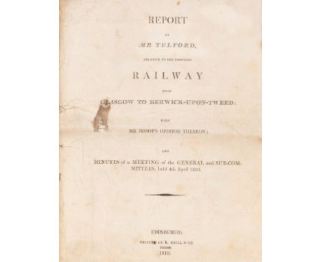
Telford (Thomas) Report...relative to the proposed Railway from Glasgow to Berwick-upon-Tweed; with Mr Jessop's Opinion thereon..., first edition, title soiled and stained with small hole not affecting text, trimmed, modern calf-backed marbled boards, Edinburgh, A.Neill & Co., 1810 § Edinburgh & Glasgow Railway. Rules and Regulations..., second issue with 'New Rule' dated October 1842 bound in, original canvas wallet with flap with blank leaves at end (some torn out) and ruled slate mounted on rear pastedown (broken), lacking pencil, preserved in modern half dark maroon morocco slip-case with pull-off top, Edinburgh, 1842 § Guide to the Glasgow & Ayrshire Railway, folding map, lithographed plates, 2 folding, original pictorial cloth, gilt, rubbed, Ayr, 1841; and 2 others, a copy of Hill's Views of the Opening of the Glasgow and Garnkirk Railway lacking the 4 lithographed plates, and a bound volume of 24 reports of meetings of shareholders/directors of the Glasgow, Paisley, Kilmarnock, & Ayr Railway 1836-47 belonging to James McCall of Daldowie, Chairman of the Board of Directors, 4to & 8vo (5)⁂ Optimism abounds in the committee's deliberations in the first item, but the scheme was stillborn. Nevertheless this is an interesting report summing up not only the costs, (£2926 per mile), but the potential benefits (£55,000 p/a), returning a nett benefit of 12%. In summing up Telford suggests that the project "is one of the most important that has ever come under my consideration". A rare work, with only 5 copies recorded worldwide, two in America, the remaining three in Scotland.The Edinburgh & Glasgow Railway opened at a cost of over a million pounds on the 21st February 1842. It was an enormous success with three times the estimated passenger traffic. By 1850 the line required 58 engines and 216 carriages. A rare survivor from the earliest days of intercity railway travel in Scotland.


Lot 1503B
Map, handcolouredEmanuel BOWEN (1694-1767) An accurate map of Lincolnshire. Divided into its Wapontakes51.8 x 70.6cm Condition report: This map is in very good condition. It is clean and bright, with crisp engravings. It seems to be on good paper with no tears or damage. This map has not however, been examed out of its frame.


Lot 1562
Thomas MARTYN (1695 - 1751) A New and Accurate Map of the County of Cornwall from an actual SurveyPublished by William FADEN 1784. Jonathan Rashleigh of Menabilly54.5 x 72.5cmNOTE: Thomas Martyn was a Cornish surveyor. He produced his very large map in 1748 and this is a smaller version of the same, published after Martyn's death. There was a later edition which did not have the dedication to Rashleigh and did included images of standing stones to the right.

-
109182 item(s)/page