We found 109198 price guide item(s) matching your search
There are 109198 lots that match your search criteria. Subscribe now to get instant access to the full price guide service.
Click here to subscribe- List
- Grid
-
109198 item(s)/page


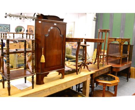
Lot 1013
A 1970's oil on canvas, depicting figures in a landscape; a framed map of the Thames and Medway; oil on panel, Winter landscape; watercolour, a street scene, Norah Simpson; watercolour of a temple; woolwork picture; watercolour still life; Continental seascape, oil; and black and white engraving


Lot 190
A map of Caernarvonshire by Christopher Saxton, late 17th early 18th CenturyBlack and white map showing various towns, 29x31cm, framed and glazed, further 19th Century map of Caernarvonshire drawn and engraved by J Archer London, two coloured engraving of Criccieth Castle and Harlech Castle, map of Cheshire drawn and engraved by J Archer and a map of Cumberland after Robert Morden. (6)

Lot 183
A new map of the counties ten miles around the cities of London and Westminster and Borough of Southwark late 18th CenturyDrawn by B Cole, 28x30cm, to engraving of London Buildings to include St Pauls and bridges, further engraving of museums etc and some coloured prints of Kensington Palace etc.

Lot 178
A collection of maps for WalesTo include map of the south west circuit of the principality of Wales comprising the counties of Cardigan, Pembroke and Caermarthen, by C & J Greenwood, London 1832-1833, 61x77cm, map of North Wales by Robert Moreden dated 1722, further map of North Wales by Cary circa 1793, Anglesey circa 1800, property map Criccieath dated 1831 and a print of Beeston Castle.


Lot 1459
C & J Greenwood - Map of the County of Suffolk from an actual survey made in the years 1823 & 1824, with vignette of the West Front of the Abbeygate Bury St Edmunds lower left, hand-coloured engraving, published by the proprietors Greenwood & Co, Regent Street, Pall Mall, London, 60 x 70cm, in modern glazed frame


Lot 331
Published late 19th century AD. In four volumes, published by William Mackenzie, 69 Ludgate Hill, London; including all the works of Robert Burns (1759-1796), with a biography and edited by Rev. George Gilfillan, titled The National Burns including the Airs of all the Songs, hardback in dark green gilt cloth with portrait to front covers, edges gilt [(i): fp.; title; 7 pl. and map; life cxxxvi pp.; works 1-88pp.; (ii): fp.; title; 7 pl.; 89-232pp.; songs 1-80pp. (iii): fp.; title; 7 pl.; text 1-200pp. (iv): fp.; title; 6 pl.; text 201-408pp.; index 1-8pp; all with woodcuts]. 4.42 kg total, 21 x 26cm (8 1/4 - 10 1/4). Property of a Kent collector; by inheritance 1970; formerly property of Jack Smith, antiquarian and collector of Hebden Bridge, Yorkshire, UK, acquired 1920s-1960s. [4, No Reserve]. Good condition; some wear to bindings, one backstrip torn. Scarce set.

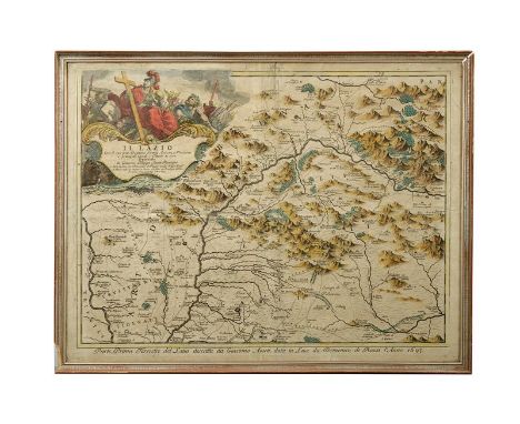
Lot 194
dating: late 17th Century provenance: Italy, A colored print depicting the map of the Lazio region; at the top, on the right side, a painting of gods and trophies, marked 'Il Lazio con le sue più Cospicue Strade Antiche e Moderne e principali Casali, e Tenute di esso Descritto da Giacomo Filippo Ameti Romano'. Marked 'Parte Prima Terrestre del Latio descritta da Giacomo Ameti data in luce da Domenico Rossi l'Anno 1693' at the bottom. Under glass, with frame. dimensions 63 x 48 cm.


Lot 78
JOHN PINE ENGRAVED MAP/CHART DEPICTING THE PROGRESS OF THE SPANISH ARMADA, this consists of two engraved plates within a decorative border published in 1739. It is part of a set of engraved reproductions of tapestries that hung in the House of Lords. Unfortunately the tapestries were destroyed by fire in 1834 so it was fortunate that John Pine along with Hubert-François Gravelot had produced this fine set of engravings. The one plate features the Isle of Wight. Hand coloured, framed and glazed.


Lot 164
Three unframed prints of classical sculptures, an aquatint, 'View of Grosvenor square', unframed, 43.5cm x 55cm, 'Eastern Hemisphere' map, another, 'The Indian and Afghan Frontiers', a map of Hong Kong, unframed (af), after John Leech, four hand coloured engravings, unframed and two black and white images of temples, unframed, 26cm x 36cm


Lot 439
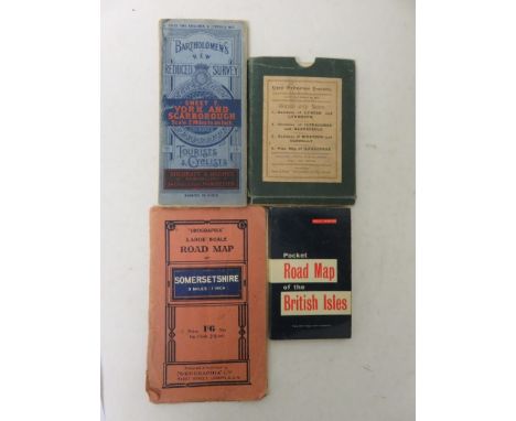
Cased set of four New Ordnance Survey maps made by Twiss and Sons showing the Environs of Lynton and Lynmouth, 24cm x 42.5cm; Environs of Ilfracome and Barnstaple, 40cm x 32.5cm; Environs of Bideford and Clovelly, 22xm x 54.5cm; and a Plan Map of Ilfracombe, 37cm x 48cm - contained in one case, tog. w. a 'Geographia' Road Map of Somersetshire, a Bartholomew's Tourist and Cyclists, Sheet 7 York and Scarborough Map, and a Pocket Road Map of the British Isles (7)


-
109198 item(s)/page