We found 109198 price guide item(s) matching your search
There are 109198 lots that match your search criteria. Subscribe now to get instant access to the full price guide service.
Click here to subscribe- List
- Grid
-
109198 item(s)/page


Lot 1053
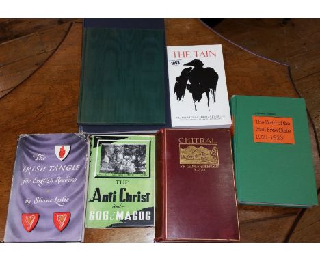
The Irish Tangle for English Readers by Shane Leslie 1946; Tha Tain; Chitrál - The Story of a Minor Siege by Sir George S. Robertson (lacking map) Meuthen 1899; The Anti Christ and Gog and Magog by Maulana Muhammad Ali. Published by Dar-ul-Kutub Islamia Limited, LAHORE, 1948; The Importance of being Earnest' Oscar Wilde Folio Society Edition 1960; STANDING ORDERS AND REGULATIONS FOR THE ARMY IN IRELAND Published by Frederick Muller Ltd.. 1st thus. 1969, Edition originally published in Dublin, 1794. Large format. Black cloth boards, gilt title to spine. 150 pages plus index; The Birth of the Irish Free State 1921-1923 by Joseph Curran (7).


Lot 100
Original 1930s POSTER 'Travel the King's Highway' by London Coastal Coaches from Victoria Coach Station. One of a set in this sale, this one is for services operated by North Western, Standerwick's, Bracewells, John Bull & Majestic Express, each of which has a coach depicted in their livery alongside a map of the routes. A vividly colourful poster by an unknown artist. Undated but clearly early mid-1930s. Size 20" x 30" (50cm x 76cm) and in very good condition. [1]

Lot 101
Original 1930s POSTER 'Travel the King's Highway' by London Coastal Coaches from Victoria Coach Station. One of a set in this sale, this one is for services operated by Midland Red, United Counties & Crosville Motor Services, each of which has a coach depicted in their livery alongside a map of the routes. A vividly colourful poster by an unknown artist. Undated but clearly early mid-1930s. Size 20" x 30" (50cm x 76cm) and in very good condition. [1]

Lot 102
Original 1930s POSTER 'Travel the King's Highway' by London Coastal Coaches from Victoria Coach Station. One of a set in this sale, this one is for services operated by Maidstone & District, Southdown & East Kent, each of which has a coach depicted in their livery alongside a map of the routes. A vividly colourful poster by an unknown artist. Undated but clearly early mid-1930s. Size 20" x 30" (50cm x 76cm), minor edge scuffs in places but overall in very good condition. [1]


Lot 124
1909 London Underground POCKET MAP -'What to see & how to see it - The Excursionist's Guide with Map'. This was the first issue to dispense with the streets background, resulting in a much clearer image, and also one of the first to use the famous UndergrounD logo. It was aimed at the leisure market with numbers referring to listed places of interest. Ex-guidebook copy in good condition with adhesive trace at one edge and alternative folding. [1]

Lot 13
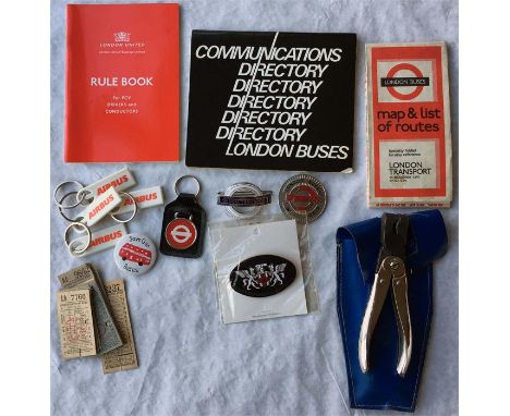
Collection of London Transport/London Buses items comprising a driver's/conductor's 1960s/70s CAP BADGE, a 1980s OFFICIAL'S PLATE Inspector 0819 (damaged enamel), a London United Busways CAP BADGE, a 1986 TICKET CLIPPER (marked 'London Buses' and punches '559') with belt holster, 1985 London Buses COMMUNICATIONS DIRECTORY, 1991 London United RULE BOOK, sundry KEY FOBS etc, 1970 BUS MAP (worn), 1940s PUNCH TICKETS. [Quantity]

Lot 138
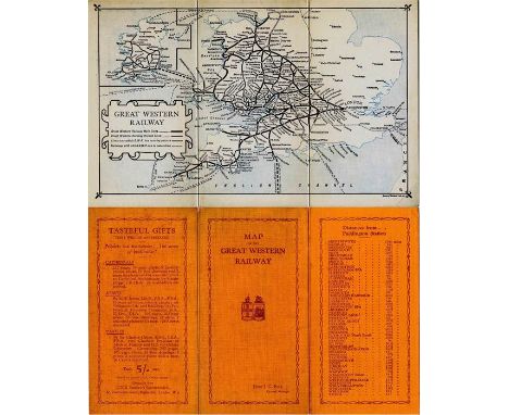
1920s Great Western Railway (GWR) linen-card POCKET MAP. A fold-out map of the company's network including services in Ireland and showing shipping connections. Undated but Felix J C Pole was General Manager in the 1920s and the item appears to be post-1924 Grouping. A little age-staining to covers but generally in very good condition. [1]
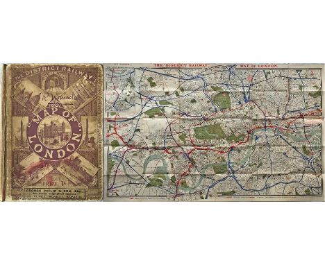
Lot 144
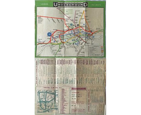
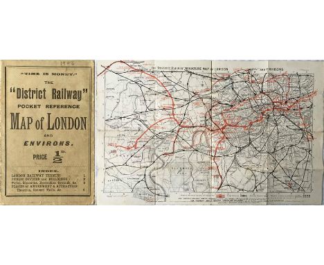
The District Railway POCKET REFERENCE MAP OF LONDON. Undated but c1906. Opens out to the District Railway Miniature Map of London and Environs, 7th edition 17.5" x 11" (45cm x 28cm). The reverse has places of amusement, train times etc. Most examples of these maps are found as guidebook copies and it is most unusual to come across a surviving pocket version (price 1/2d). Includes the early tube lines. Lightly used with some wear but still very presentable. [1]

Lot 161
The "District Railway" MAP of London, 6th edition, undated but c1903. A large-scale, full-colour map (42" x 26", 107cm x 66cm), linen-backed and folded into hard covers. This is the 3rd of three known issues of this edition and shows the first tube lines in blue as well as the District's extension now open to Upminster, Southend etc. In used condition, name and small stain on cover, but very reasonable overall. [1]
Lot 169
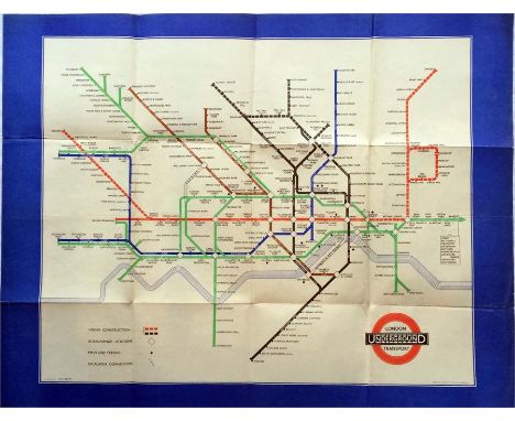
1940 London Transport Underground POSTER MAP designed by H C Beck and featuring a wide blue border. A war-time issue which shows the planned extensions of the Central Line to Denham and Ongar and of the Northern Line to Bushey Heath and Alexandra Palace. Features the thickened lines to include the line names. Measuring 33" x 26" (84cm x 66cm) and folded, the poster is in good condition with just a little wear on some of the folds and some light creasing elsewhere. [1]
Lot 175
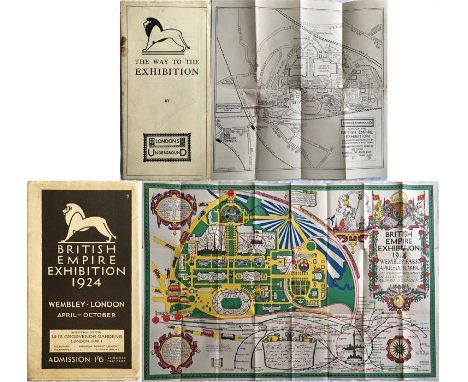
1924 British Empire Exhibition at Wembley items comprising the official fold-out PLAN & MAP designed by Kennedy North in a style similar to MacDonald Gill with an Underground map with calligraphed station names and elaborate, colourful illustrations plus the Underground Group fold-out LEAFLET 'The Way to the Exhibition' including a plan with rail and bus stations shown. Both in used condition with some wear but still reasonable. [1]

Lot 177
Reading Corporation Transport official TIMETABLE BOOKLET of Tramcar & Omnibus Services dated May-September 1934, includes fold-out map, covers detached, plus same operator's TIMETABLE BOOKLET of Trams, Buses and Trolley Buses dated Novemver 1937, lightly-used, includes fold-out map, plus Ribble Motor Services WW2 National Emergency TIMETABLE BOOKLET of stage carriage services, East Lancs Area, dated May 1944 (lightly used). [3]

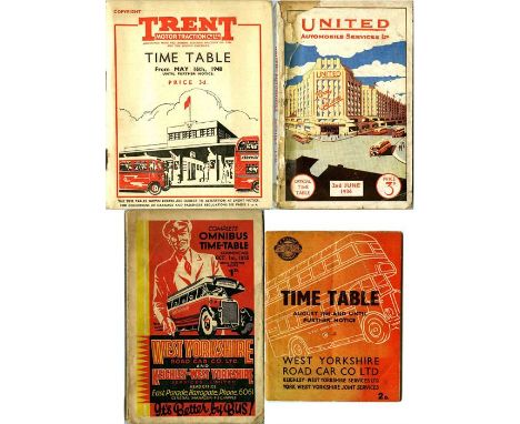
Lot 179
Trent Motor Traction Co TIMETABLE BOOKLET dated May 1948, with fold-out map, United Automobile Services TIMETABLE BOOKLET dated June 1936, with fold-out map, repaired cover, West Yorkshire Road Car Co & Keighley-West Yorkshire Services TIMETABLE BOOKLET dated October 1935 (includes loose fold-out map) and West Yorkshire Road Car Co WW2 TIMETABLE BOOKLET dated August 1944 (includes fold-out map). Used condition, corroded staples. [4]
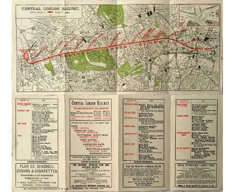
Lot 18
c1902 Central London Railway fold-out POCKET MAP produced to promote its service from Bank to Shepherds Bush. The line is superimposed in red on a street-map background and shows the generating station and depôt at the western end with an inset plan of the subways at Bank on the top right. The reverse has travel and ticket information etc. A lightly-used but very reasonable copy. [1]

Lot 181
c1910 LCC TRAMWAY MAP of London and Suburbs 'showing the LCC Tramways and their connections with other tramways and tube railways'. A fold-out paper map inside card covers produced by G W Bacon & Co Ltd 'under the direction of the London County Council', the map pre-dates the LCC's own issues. Shows the whole County of London area. Worn, fragile covers, map has some repairs on reverse but is very reasonable still. A very scarce issue. [1]
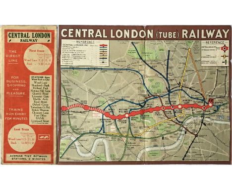
Lot 186
1912 Central London Railway POCKET MAP titled 'Central London (Tube) Railway' with a brown border and in a very similar style to maps produced by the Underground Group (who took over the CLR the following year) but with considerable prominence given to its own line. The Ealing Broadway extension, not yet open, is shown in hatched form and that to Liverpool Street shown as operational. In lightly-used condition with a little wear but very presentable. [1]


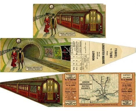
Lot 231
London Underground Electric Railways 1907 advertising CARD with MAP, one of a series featuring different stations, in this case Leicester Square with an illustration of a Charing Cross, Euston & Hampstead Rly train. Opens into 3 parts by lifting the train to reveal more of the station, including posters, and fares, journey times, season-ticket rates & a small map of the Underground. Minor surface losses to the reverse with traces of clear adhesive, otherwise very good. [1]

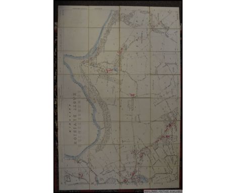
![The "District" [Railway] MAP of Greater London & Environs, 2nd edition, undated but c1908 (shows Franco-British Exhibition).](https://cdn.globalauctionplatform.com/75f7ffae-70c6-4046-b59e-a5de0151b9e2/c3ae3eb8-c6e4-406d-9cb4-a61a0122aeb5/468x382.jpg)
Lot 245
The "District" [Railway] MAP of Greater London & Environs, 2nd edition, undated but c1908 (shows Franco-British Exhibition). A large-scale, full-colour map (42" x 26", 107cm x 66cm), linen-backed and folded into hard covers. Bakerloo, Hampstead & Piccadilly tubes shown in bold, non-Group tubes, eg Central and C&SLR, not highlighted! Well used, with worn covers, but intact and still very reasonable. [1]

Lot 25
c1914 Bacon's 'portable' Railway, Tramway & Underground RAILWAY MAP OF LONDON with 'Descriptive Guide'. Folds out in 21 panels to 30" x 20" (76cm x 51cm). A very detailed, attractive & informative map with information on the reverse. Undated but shows Central London Railway's Ealing extension as under construction. Well used with fragile covers and some repairs at folds. [1]

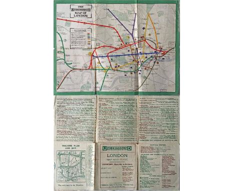
Lot 256
1919 London Underground MAP OF THE ELECTRIC RAILWAYS OF LONDON 'What to See & How to See it' with print-code 395-500M-2-10-19. Has the red, open, bullseye circle on the cover and opens out in 8 panels to 13.7" x 10.9" (34 x 28cm). Some wear at the folds and fold-corners but overall a good copy. [1]


Lot 273
Selection of London Transport mainly paper EPHEMERA comprising Tramlink presentation FOLDER with leaflets, pamphlets, postcards plus Sept 1959 London Transport MAGAZINE plus 1993 Diamond Jubilee MAGAZINE plus 2 x Jubilee PRESENTATION PACKS with MEDALLIONS plus 1995 large-print TUBE MAP plus envelope of 10 whole-plate PHOTOGRAPHS of London & other trams, ancient and modern. In good condition. [Quantity]

Lot 276
Railway Clearing House OFFICIAL RAILWAY MAP of London & its Environs dated 1921. Linen-backed, inside hard covers with gilt lettering, opens out to 51" x 41" (130cm x 104cm). The RCH produced the most definitive UK railway maps from 1871 onwards and this London issue in full colour shows all the main-line and Underground railways. In very good condition. [1]
Lot 278
1911 London Underground POCKET MAP. Printed by Johnson, Riddle & Co Ltd, interesting features are the 3 stations at Hammersmith and the inclusion of the LBSCR lines to Crystal Palace. Places of interest and theatre map on the reverse. In well-used condition with wear at some folds, small corner-partings and pencilled annotations on reverse but still very reasonable. Ex-guidebook copy, has been re-folded. [1]

Lot 285
Set of London Underground ENGINEER'S TRAIN ROUTE MAPS on fold-out laminated cards showing the routes, in text and highlighted on the Underground map, from Ruislip and Lillie Bridge depôts to the various lines and sections of line. Issues numbered 1-30 minus 11 and dated 2005. In excellent condition. [29]


Lot 288
1908 Central London Railway MAP 'To the Franco-British Exhibition'. Although issued independently by the CLR with all their own information on the reverse, the map is the standard, green-bordered London Electric Railways issue of the time. In very good condition with no material blemishes. [1]

Lot 291
1924 British Empire Exhibition at Wembley official, fold-out PLAN & MAP designed by Kennedy North in a style similar to MacDonald Gill with an Underground map with calligraphed station names and elaborate, colourful illustrations. In lightly- used condition with some age-spots on the cover but overall a very good copy. [1]
-
109198 item(s)/page